Archiv - Nach Datum
Archiv - Nach Aktivität
-
Andere Tour (2)
- Kayaking (2)
-
Fahrradtour (98)
- Fahrradtour Straße (75)
- Fahrradtour gemischt (23)
-
Fahrzeugtour (6)
- Autotour (6)
-
Fußtour (1482)
- Bergtour (903)
- Jogging (1)
- Spaziergang (40)
- Wanderung (538)
-
Skitour (98)
- Langlauf (39)
- Tourenskilauf (59)
Gesammelte Listen
-
Utvalgte topper og turmål i Bergen
(301/306)
 98%
98% -
Øytopper Hordaland
(26/27)
96%
-
Alle topper i Bergen
(335/350)
95%
-
Vaksdal ≥ 100m pf.
(59/63)
93%
-
Søyler (fastmerker) i Bergen
(91/100)
91%
-
Nordhordland PF >= 100m
(198/221)
89%
-
Fitjar ≥ 100m pf.
(6/7)
85%
-
Opptur Hordaland
(133/159)
83%
-
Modalen ≥ 100m pf.
(23/30)
76%
-
Hordaland ≥ 500m pf.
(23/30)
76%
-
Masfjorden ≥ 100m pf.
(42/55)
76%
-
Kvam ≥ 100m pf.
(32/44)
72%
-
Stasjoner på Bergensbanen
(26/36)
72%
-
Voss ≥ 100m pf.
(67/97)
69%
-
Hordaland ≥ 100m pf.
(501/862)
58%
-
Dagsturhyttene i Vestland
(31/60)
51%
-
Sunnhordland PF >= 100m
(82/186)
44%
-
DNT-hytter i Hordaland
(18/45)
40%
-
Kvinnherad ≥ 100m pf.
(26/79)
32%
-
Hordaland: Hardanger PF>=100m
(116/357)
32%

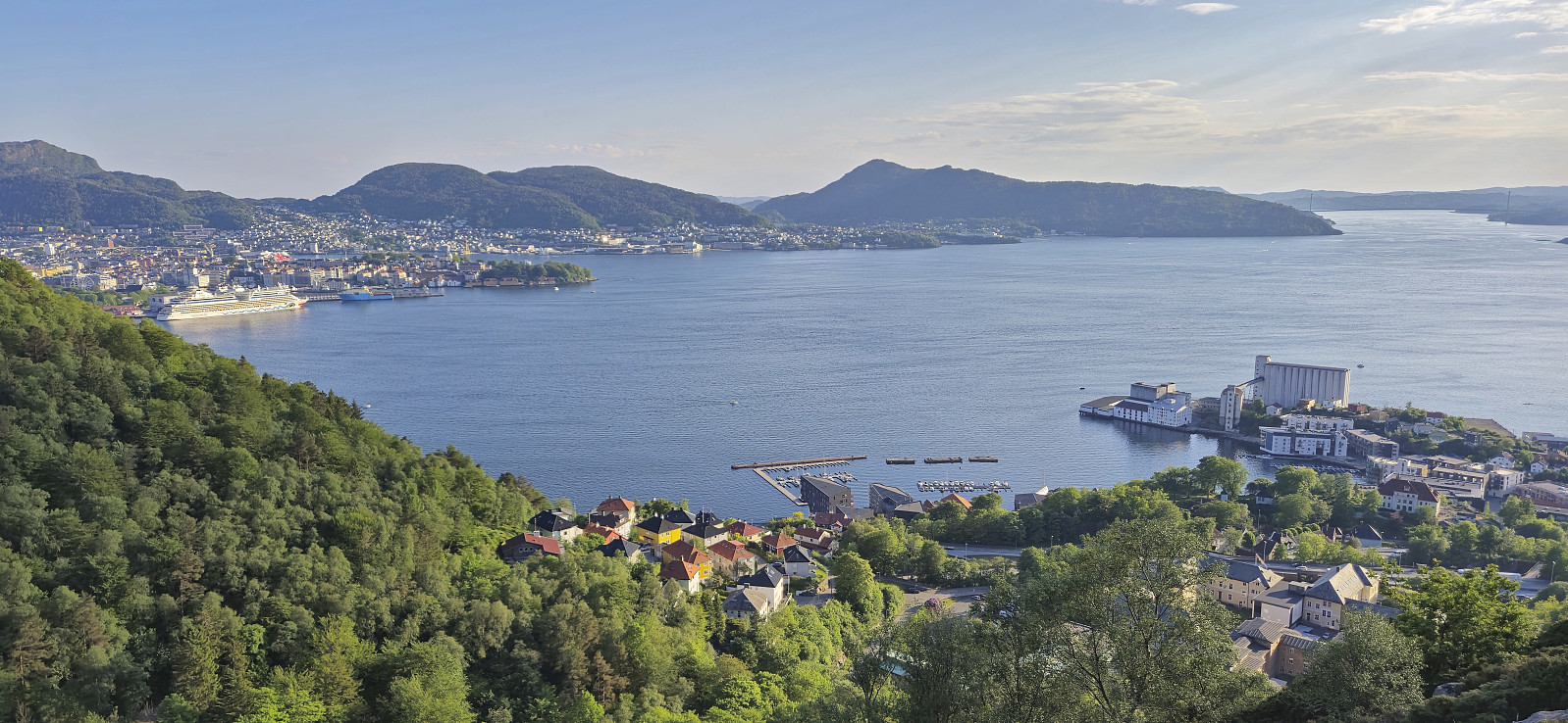
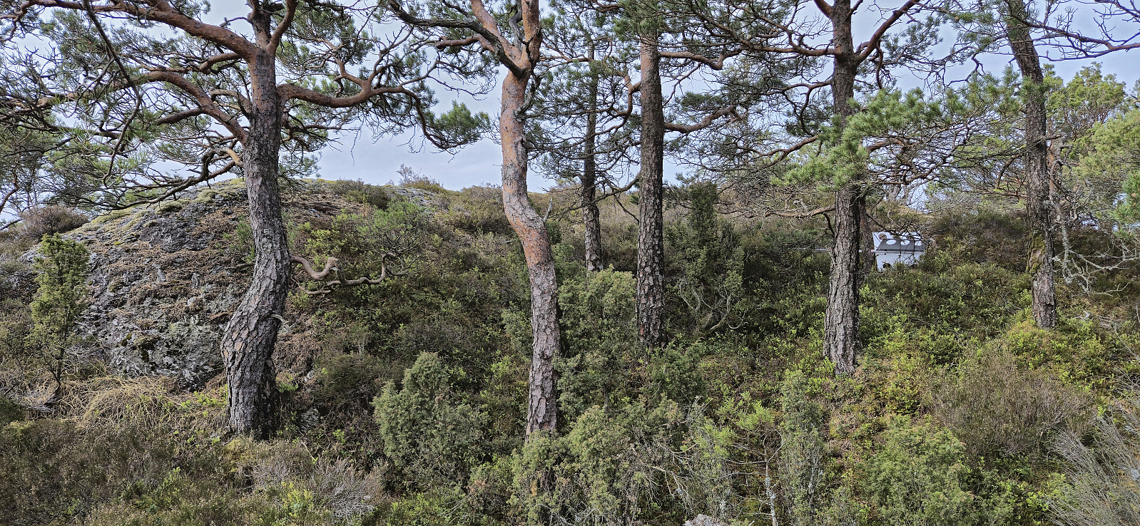
Sandviksbatteriet, Sandvikspilen and Sandviksfjellet
- Datum:
- 02.06.2024
- Tourcharakter:
- Bergtour
- Tourlänge:
- 2:17h
- Entfernung:
- 10,0km
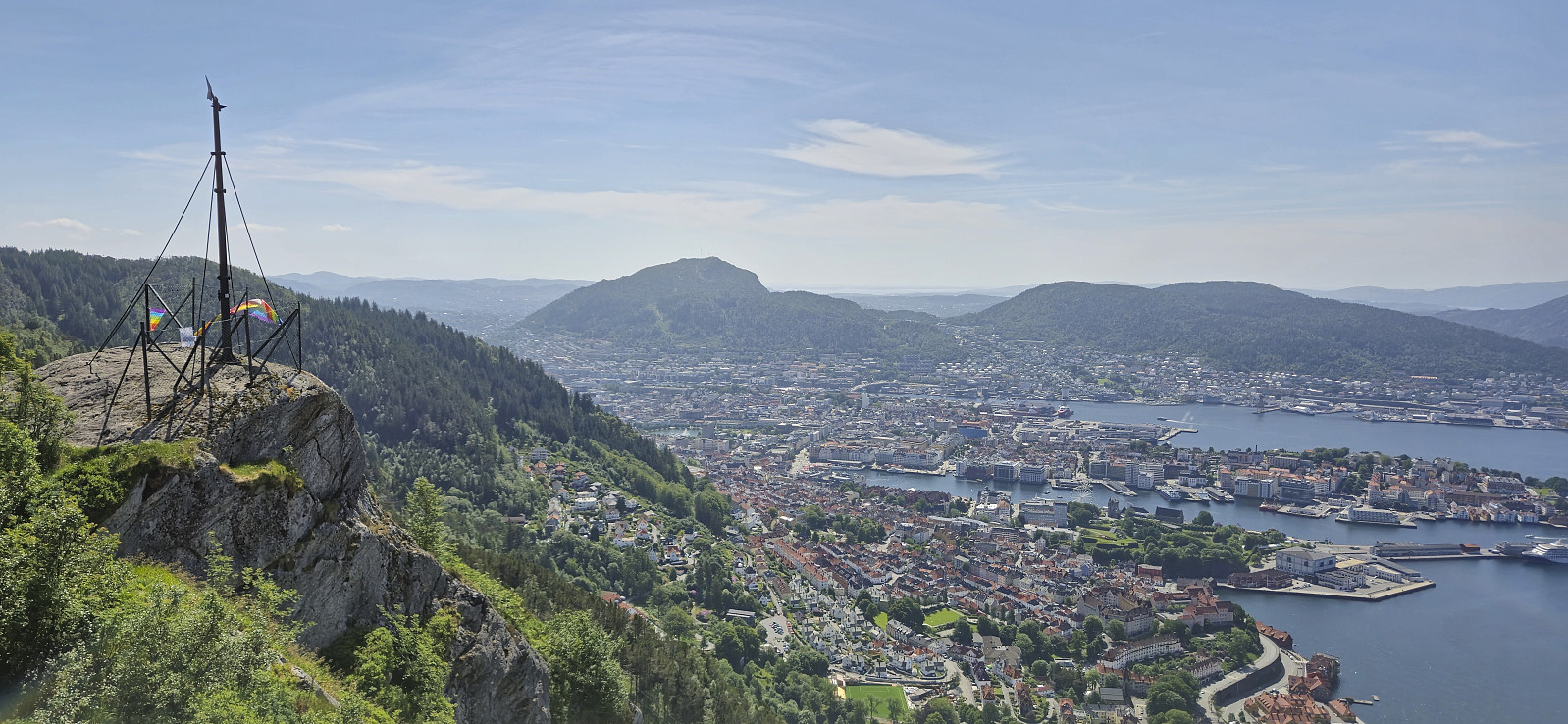 Local Sunday hike in Sandviken.
Mysterfjell and Åsen
- Datum:
- 01.06.2024
- Tourcharakter:
- Bergtour
- Tourlänge:
- 4:57h
- Entfernung:
- 12,5km
 I started by taking the train to Dale and from there the bus to Eidslandet where I got off at Olavika at the start of Mystervegen. After passing the last house in Mystervegen I passed through a gate, and later on a second gate, and continued on a tractor road that soon turned into a marked trail that lead me up to Leiro . Here I had hoped to locate a trail towards Storfjellet but only found weak animal tracks and before long I was simply aiming for Storfjellet and heading off-trail in that direction. Thankfully the terrain was easy to navigate and I arrived at the summit without any issues. Excellent views back down towards Myster and Eidslandet from just west of the highest point.
Due to lots of flies I however did not stay long before turning my attention to the real goal of the day: Mysterfjell . Not sure where the name >>>
I started by taking the train to Dale and from there the bus to Eidslandet where I got off at Olavika at the start of Mystervegen. After passing the last house in Mystervegen I passed through a gate, and later on a second gate, and continued on a tractor road that soon turned into a marked trail that lead me up to Leiro . Here I had hoped to locate a trail towards Storfjellet but only found weak animal tracks and before long I was simply aiming for Storfjellet and heading off-trail in that direction. Thankfully the terrain was easy to navigate and I arrived at the summit without any issues. Excellent views back down towards Myster and Eidslandet from just west of the highest point.
Due to lots of flies I however did not stay long before turning my attention to the real goal of the day: Mysterfjell . Not sure where the name >>>
Ørneberget and Furukammen
- Datum:
- 31.05.2024
- Tourcharakter:
- Bergtour
- Tourlänge:
- 0:54h
- Entfernung:
- 4,0km
 Short local evening hike.
Skaugumsåsen and Djupdalsåsen
- Datum:
- 22.05.2024
- Tourcharakter:
- Bergtour
- Tourlänge:
- 3:58h
- Entfernung:
- 11,1km
 When attending a two-day conference at Holmen Fjordhotell outside Oslo we had to arrive the day before (to catch the morning session on the first day). Upon arriving we quickly decided to take advantage of the excellent weather for some afternoon hiking. After buying some food nearby we took a bus to Solgården, followed the road up to Semsvannet utfartsparkering and from there continued on the marked trail to Skaugumsåsen .
The steep ascent from the south bordered on scrambling, and the dry sand did not make it any easier, but by being extra careful it did not take long before the terrain flattened out and we could start enjoying the excellent views. There were several vantage points to choose from and we stopped for a very late lunch break at one of them.
As returning our ascent route was not very tempting, and I had not yet visited the highest point, >>>
When attending a two-day conference at Holmen Fjordhotell outside Oslo we had to arrive the day before (to catch the morning session on the first day). Upon arriving we quickly decided to take advantage of the excellent weather for some afternoon hiking. After buying some food nearby we took a bus to Solgården, followed the road up to Semsvannet utfartsparkering and from there continued on the marked trail to Skaugumsåsen .
The steep ascent from the south bordered on scrambling, and the dry sand did not make it any easier, but by being extra careful it did not take long before the terrain flattened out and we could start enjoying the excellent views. There were several vantage points to choose from and we stopped for a very late lunch break at one of them.
As returning our ascent route was not very tempting, and I had not yet visited the highest point, >>>
Ørneberget, Rognåsen and Håmanen
- Datum:
- 21.05.2024
- Tourcharakter:
- Bergtour
- Tourlänge:
- 1:59h
- Entfernung:
- 7,0km
 Local evening hike after work.
Påskåsen
- Datum:
- 20.05.2024
- Tourcharakter:
- Bergtour
- Tourlänge:
- 2:01h
- Entfernung:
- 5,0km
 The last day of a long weekend was spent visiting Påskåsen . I started by taking the boat from Strandkaiterminalen in Bergen to Leirvik. Here there was another boat waiting for the final leg to Fjelbergøy. I was the only passenger disembarking, roughly two hours after leaving Bergen. By following the road north I soon arrived at a tractor road that took me up to the unmarked trailhead. (PB indicates a parking lot at the end of this road, but there is only room for one car and I do not think the area is really meant for parking.)
Thanks to previous trip reports I here left the tractor road and continued on an unmarked trail heading south/southwest. The trail later turned towards the summit and could be easily followed all the way to the highest point. Limited views from the top, except for an opening >>>
The last day of a long weekend was spent visiting Påskåsen . I started by taking the boat from Strandkaiterminalen in Bergen to Leirvik. Here there was another boat waiting for the final leg to Fjelbergøy. I was the only passenger disembarking, roughly two hours after leaving Bergen. By following the road north I soon arrived at a tractor road that took me up to the unmarked trailhead. (PB indicates a parking lot at the end of this road, but there is only room for one car and I do not think the area is really meant for parking.)
Thanks to previous trip reports I here left the tractor road and continued on an unmarked trail heading south/southwest. The trail later turned towards the summit and could be easily followed all the way to the highest point. Limited views from the top, except for an opening >>>
Gaukavarden and Hinderåsen
- Datum:
- 09.05.2024
- Tourcharakter:
- Bergtour
- Tourlänge:
- 1:23h
- Entfernung:
- 4,8km
 A short hike in Arna to visit Gaukavarden and Hinderåsen (the latter added as its own PB-element). I got off at "Haukeland sør" and followed Brattlandsvegen until just west of the summit. From there I headed off-trail to the summit which was easily reached. The views were limited by the low-hanging clouds but I could at least see Haukelandsvatnet.
I descended north along a weak trail that turned into a tractor road before connecting with the gravel road north of Gaukavarden. Next, I made a quick visit of Hinderåsen , which despite its name (directly translates into "obstacle hill"), could be ascended without any issues. It even provided ok views to the north with Loneheia visible in the distance.
While there was a weak trail continuing north from the highest point, after passing through a gate, I decided to not >>>
A short hike in Arna to visit Gaukavarden and Hinderåsen (the latter added as its own PB-element). I got off at "Haukeland sør" and followed Brattlandsvegen until just west of the summit. From there I headed off-trail to the summit which was easily reached. The views were limited by the low-hanging clouds but I could at least see Haukelandsvatnet.
I descended north along a weak trail that turned into a tractor road before connecting with the gravel road north of Gaukavarden. Next, I made a quick visit of Hinderåsen , which despite its name (directly translates into "obstacle hill"), could be ascended without any issues. It even provided ok views to the north with Loneheia visible in the distance.
While there was a weak trail continuing north from the highest point, after passing through a gate, I decided to not >>>
Tverrfjellet
- Datum:
- 01.05.2024
- Tourcharakter:
- Bergtour
- Tourlänge:
- 2:28h
- Entfernung:
- 7,7km
 After our visit of Skorpo , we wanted to have a go at one more peak before heading back to Bergen and decided on Tverrfjellet in Omvikdalen. (To be more precise, we decided on the lower peak with that name on the eastern side of Omvikdalen, as there is also a higher peak with the same name on the other side. Not a lot of points for creativity when naming mountains in this area in other words...)
We parked at a small parking lot at the trailhead and from there followed a gravel road up to Aterstadvatnet. Here we had to cross the river to continue on the marked trail to the summit. There were several steppingstones that made the crossing straightforward, however avoiding wet shoes was not really an option.
Kjell here decided to turn back and returned to his car, while Petter and I started on the initially relatively steep ascent >>>
After our visit of Skorpo , we wanted to have a go at one more peak before heading back to Bergen and decided on Tverrfjellet in Omvikdalen. (To be more precise, we decided on the lower peak with that name on the eastern side of Omvikdalen, as there is also a higher peak with the same name on the other side. Not a lot of points for creativity when naming mountains in this area in other words...)
We parked at a small parking lot at the trailhead and from there followed a gravel road up to Aterstadvatnet. Here we had to cross the river to continue on the marked trail to the summit. There were several steppingstones that made the crossing straightforward, however avoiding wet shoes was not really an option.
Kjell here decided to turn back and returned to his car, while Petter and I started on the initially relatively steep ascent >>>
Skorpo
- Datum:
- 01.05.2024
- Tourcharakter:
- Bergtour
- Tourlänge:
- 1:59h
- Entfernung:
- 5,2km
 Shortly after our successful ascent of Storhaugen på Seløy , Kjell managed to secure yet another boat ride, this time to from Stølavika to the island of Skorpo . Once more both Petter and Endre were eager to join, but in the end Endre decided to instead use the one to retrieve his car in Ortnevik (left there after his impressive skiing trip to Voss ).
Petter picked me up at 07:00 for the drive to Gjermundshamn and the ferry to Årsnes. We met up with Kjell on the ferry and drove together from Årsnes to the agreed upon pickup point in Stølavika, where only minutes later the boat showed up and transported us to Søre Skorpevågen at Skorpo. A short trip taking less than ten minutes.
From Søre Skorpevågen we did as recommend by the boat owner and followed a gravel road west until reaching a tractor road, and later trail, marked with red T's, which we then proceeded to follow up to the cairn at the hill east >>>
Shortly after our successful ascent of Storhaugen på Seløy , Kjell managed to secure yet another boat ride, this time to from Stølavika to the island of Skorpo . Once more both Petter and Endre were eager to join, but in the end Endre decided to instead use the one to retrieve his car in Ortnevik (left there after his impressive skiing trip to Voss ).
Petter picked me up at 07:00 for the drive to Gjermundshamn and the ferry to Årsnes. We met up with Kjell on the ferry and drove together from Årsnes to the agreed upon pickup point in Stølavika, where only minutes later the boat showed up and transported us to Søre Skorpevågen at Skorpo. A short trip taking less than ten minutes.
From Søre Skorpevågen we did as recommend by the boat owner and followed a gravel road west until reaching a tractor road, and later trail, marked with red T's, which we then proceeded to follow up to the cairn at the hill east >>>
Steinen and Øyjordsåsen
- Datum:
- 23.04.2024
- Tourcharakter:
- Bergtour
- Tourlänge:
- 2:21h
- Entfernung:
- 6,9km
 When a two-day meeting at Solstrand came to an end, I made the rather unusual choice of skipping the concluding lunch at the hotel and instead changed into my hiking gear and hopped on a bus to Sævareid with the goal of visiting the final two peaks I had left in Bjørnafjorden. After switching buses at Kilen I got off at "Sævareid sør". This put me right at the start of Markhusvegen and I now had just under 2.5 hours to complete my hike and return to the bus stop before the last bus of the day would take me back to Bergen.
I started by following Markhusvegen up towards Markhus but left the gravel road just as it flattened out and instead headed off-trail towards the summit of Steinen , leaving my heavy backpack behind at the first opportunity. The ascent started quite steep and even required some >>>
When a two-day meeting at Solstrand came to an end, I made the rather unusual choice of skipping the concluding lunch at the hotel and instead changed into my hiking gear and hopped on a bus to Sævareid with the goal of visiting the final two peaks I had left in Bjørnafjorden. After switching buses at Kilen I got off at "Sævareid sør". This put me right at the start of Markhusvegen and I now had just under 2.5 hours to complete my hike and return to the bus stop before the last bus of the day would take me back to Bergen.
I started by following Markhusvegen up towards Markhus but left the gravel road just as it flattened out and instead headed off-trail towards the summit of Steinen , leaving my heavy backpack behind at the first opportunity. The ascent started quite steep and even required some >>>
