Archiv - Nach Datum
Archiv - Nach Aktivität
-
Andere Tour (1)
- Expedition (1)
-
Andere Wintertour (10)
- Schneeschuhtour (10)
- Fahrradtour (2)
- Fußtour (228)
-
Klettern (8)
- Alpinklettern (7)
- Mixed-Klettern (1)
-
Skitour (49)
- Randonnée/Telemark (49)


Gesammelte Listen
-
Romsdal ≥ 100m pf.
(134/301)
 44%
44% -
Sunnmøre ≥ 100m pf.
(78/531)
14%
-
Norges 1000 største fjell målt i primærfaktor
(52/1000)
5%

With my daughter Sol to the summit of Mount Storhornet
- Datum:
- 26.03.2016
- Tourcharakter:
- Wanderung
- Tourlänge:
- 2:44h
- Entfernung:
- 6,8km
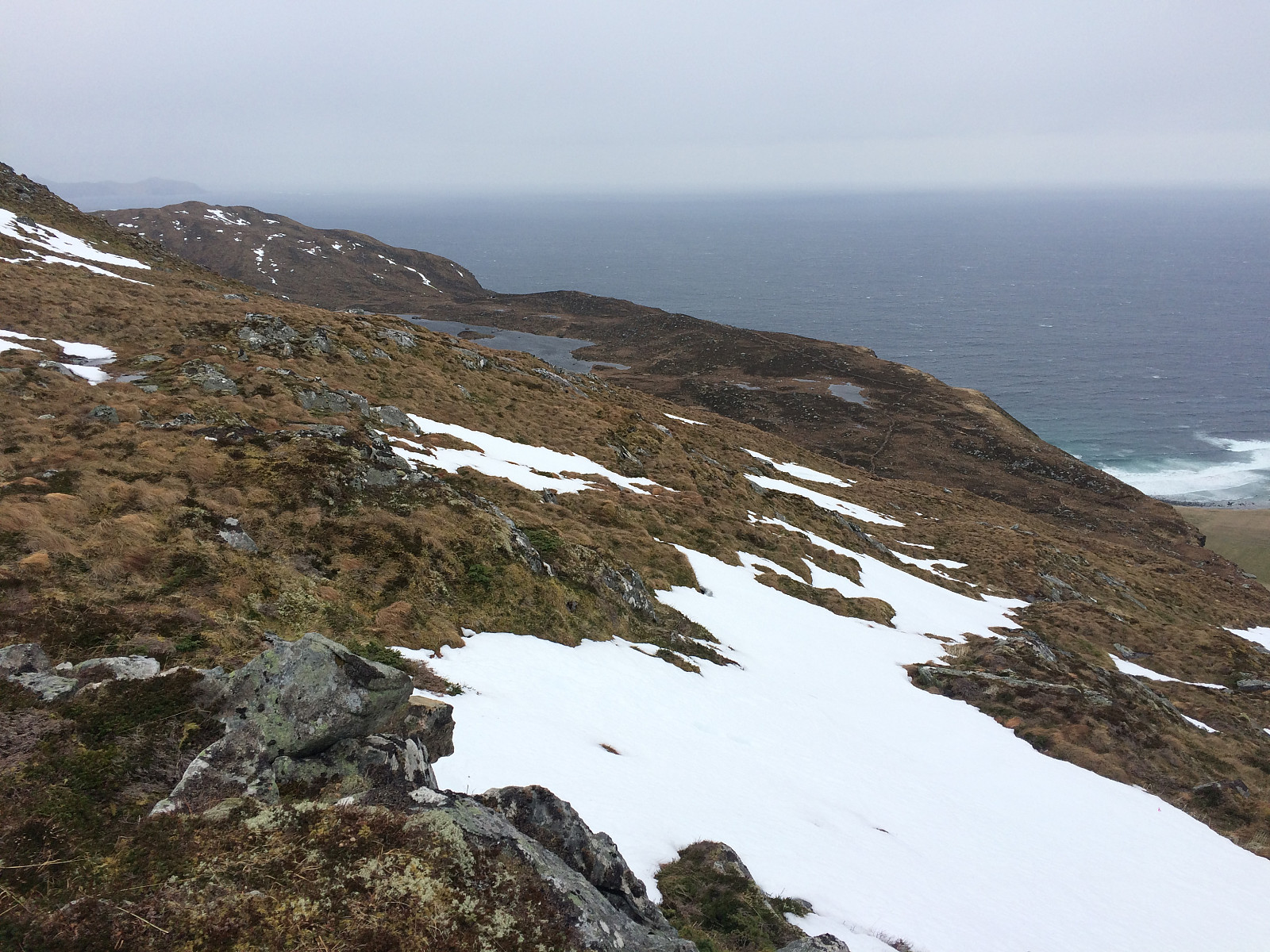 As on multiple other occasions, I ascended the summit of Storhornet, the highest peak on the mountain of the island Godøy, in Giske Municipality, in Møre & Romsdal County on the west coast of Norway. I have frequently climbed this mountain alone, but on several occasions I've also climbed the mountain along with one of my children; and on this day it was my oldest daughter Sol who joined me for the hike. We parked our car on the parking lot in Hestvika [i.e. The Horse's Bay], and started out from there. This parking place is spacious, and it's free of charge, so I recommend it to anyone who's planning to do this hike. The trail up the north face of the mountain starts about 100 meters from the parking lot. There is a combined pedestrian and bicycle lane on the other side of the road, >>>
Another Winter Hike to Mount Storehornet on Godøy Island
- Datum:
- 05.03.2016
- Tourcharakter:
- Wanderung
- Tourlänge:
- 2:45h
- Entfernung:
- 7,0km
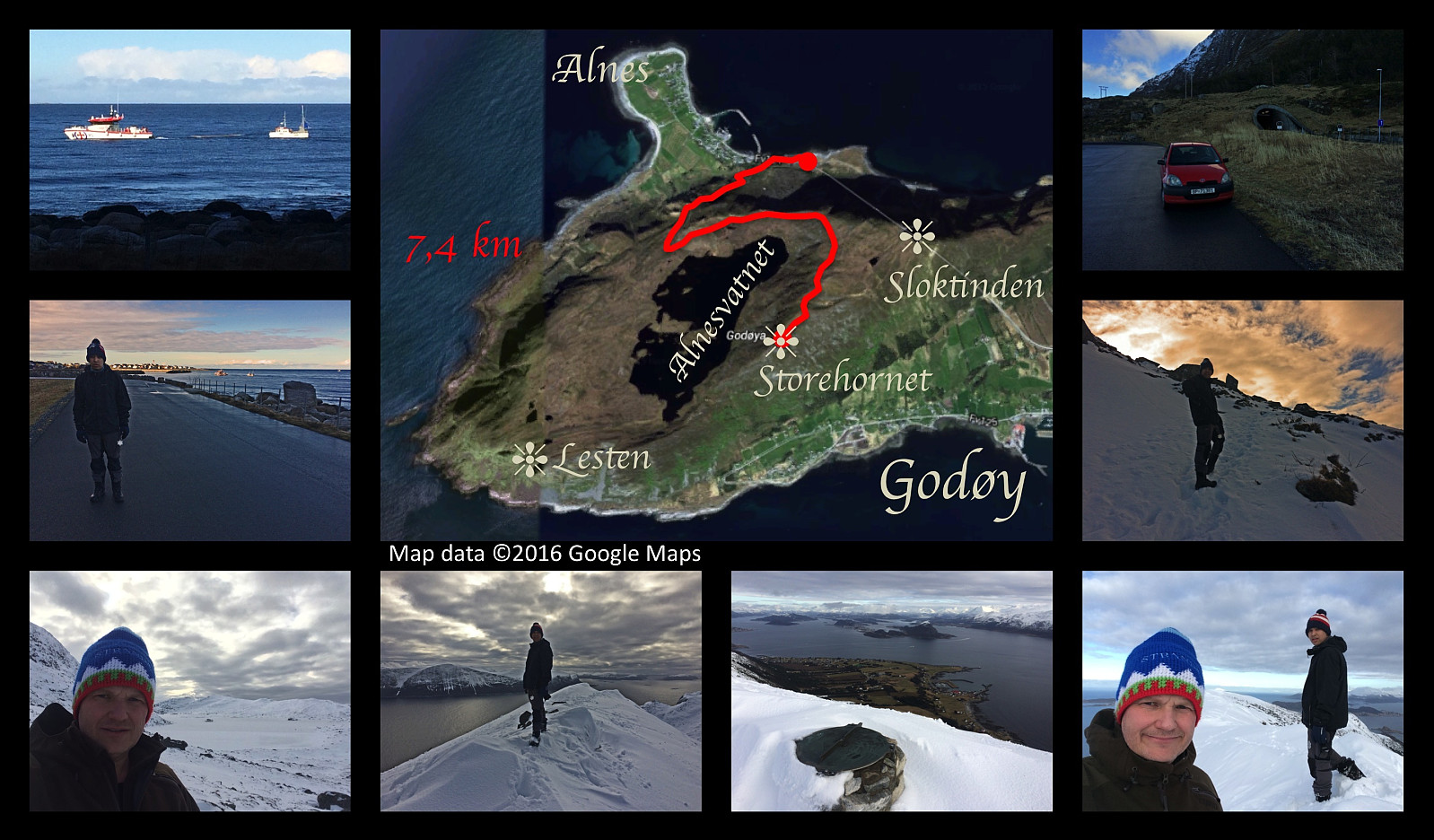 On this day a made a hike to the summit Storhornet on Godøy Island off the coast of Møre & Romsdal County on the west coast of Norway, along with my son Dag. We parked at the new parking lot in Hestvika [i.e. The Horse's Bay], where there's plenty of space even during the tourist season, and set out from there. We followed the regular route up to the plateau where Lake Alnesvatnet (250 m.a.m.s.l.) is located, then continued along the lake till we reached the northeast end of it, from where we followed the usual path along the mountain ridge to the summit of the mountain. There was snow all the way up on this particular day (snow often comes and goes during the winter, as the island is located within the Gulf Stream of the Atlantic Ocean). Back down we used the same route as we had used >>>
Winter Hike to the "Big Horn" on Godøy Island
- Datum:
- 06.02.2016
- Tourcharakter:
- Wanderung
- Tourlänge:
- 4:05h
- Entfernung:
- 10,4km
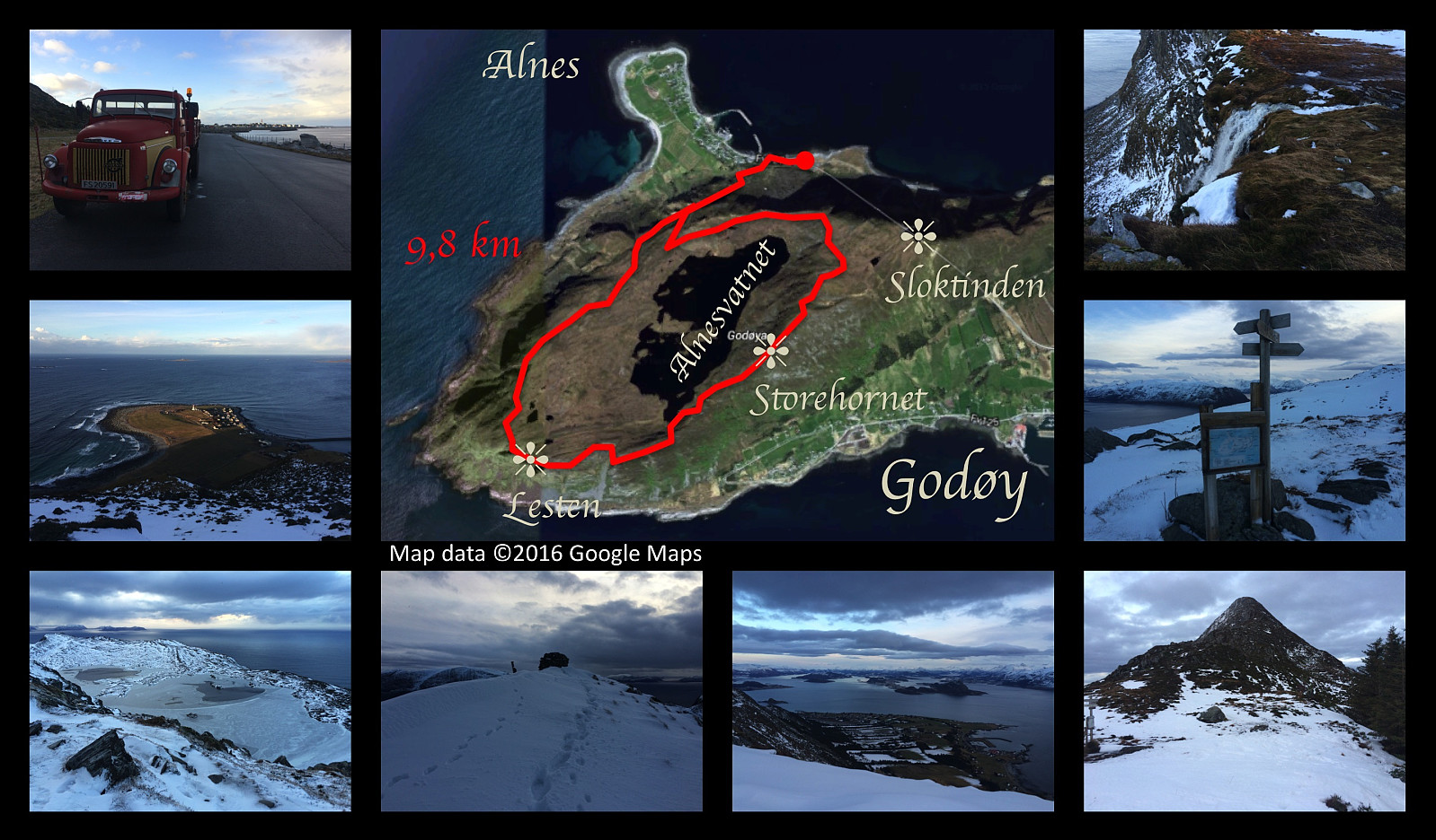 I've been hiking to the summits Storhornet and Lesten on the mountain of the island Godøy multiple times. This afternoon I did this trek again. I set out from the relatively new parking lot in the bay called Hestvika [i.e. The Horse's bay]; which is rather spacious, making it possible even to park there with a lorry. I frequently borrow either my wife's car or my son's car when I go trekking, but on this day they were both at work; hence I had to use my truck/lorry, as that's the only vehicle owned by me. I climbed up to the plateau on which lake Alnesvatnet is located, and continued up the ridge just north east of the lake, towards Storhornet. The trail curves southwards, and then southwest as you approach the summit of Storhornet (495 m.a.m.s.l.). From Storhornet it is possible to just continue >>>
Ettermiddags- og kveldstur til Frostatinden
- Datum:
- 16.01.2016
- Tourcharakter:
- Wanderung
- Tourlänge:
- 3:30h
- Entfernung:
- 11,2km
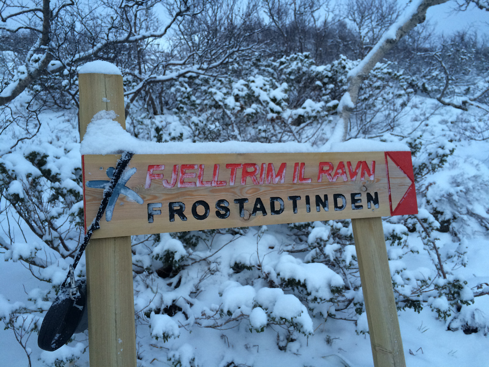 Frostadtinden er et fjell mange av de jeg kjenner har vært på, så jeg fant ut at jeg også ville ta meg en tur dit. "Kjør Nakkedalen til endes," sa min sønn til meg, "og så parkerer du på parkeringsplassen du kommer til rett før veien begynner å gå nedover igjen mot Fiksdalen. Jeg gjorde som han foreslo, og la i vei på tur derfra. Jeg hadde stått opp litt sent denne lørdagen, og klokka var snart tre allerede, men jeg hadde hodelykt med meg, og dessuten litt nistemat.
Fra Reset parkeringsplas går det to forskjellige stier/traséer opp til Frostadtinden, og skal man tro skiltene som står der, er begge veier omtrent like langt å gå. Den ene går omtrent rett sørover fra parkeringsplassen, og så rett opp på fjellryggen som strekker seg fra Vatneeidet til Frostatinden, >>>
Frostadtinden er et fjell mange av de jeg kjenner har vært på, så jeg fant ut at jeg også ville ta meg en tur dit. "Kjør Nakkedalen til endes," sa min sønn til meg, "og så parkerer du på parkeringsplassen du kommer til rett før veien begynner å gå nedover igjen mot Fiksdalen. Jeg gjorde som han foreslo, og la i vei på tur derfra. Jeg hadde stått opp litt sent denne lørdagen, og klokka var snart tre allerede, men jeg hadde hodelykt med meg, og dessuten litt nistemat.
Fra Reset parkeringsplas går det to forskjellige stier/traséer opp til Frostadtinden, og skal man tro skiltene som står der, er begge veier omtrent like langt å gå. Den ene går omtrent rett sørover fra parkeringsplassen, og så rett opp på fjellryggen som strekker seg fra Vatneeidet til Frostatinden, >>>
A 2nd Trip Across Mount Ulriken, Rundemanen and Blåbanen
- Datum:
- 06.01.2016
- Tourcharakter:
- Wanderung
- Tourlänge:
- 6:43h
- Entfernung:
- 20,0km
 Whenever I'm going to be on call during the weekend at my work as a medical doctor and a cardiac surgeon at our hospital in Bergen, I have the advantage of having a day off on Wednesday prior to that weekend. This was such a Wednesday, and I had decided to make the most of it; and so I set out for a long trek. Having a hike like this is actually a very nice way to seek recreation prior to three days of being continuously on call.
Nature is actually quite beautiful upon the Bergen mountains. It was, however, a rather frozen landscape that met me in the mountains on this particular day. It was still beautiful, but it was beautiful inn a different way. I climbed Mount Ulriken as I've done on multiple occasions, and then from the west peak of Ulriken, I went south east, to a cabin called Turnerhytten
Whenever I'm going to be on call during the weekend at my work as a medical doctor and a cardiac surgeon at our hospital in Bergen, I have the advantage of having a day off on Wednesday prior to that weekend. This was such a Wednesday, and I had decided to make the most of it; and so I set out for a long trek. Having a hike like this is actually a very nice way to seek recreation prior to three days of being continuously on call.
Nature is actually quite beautiful upon the Bergen mountains. It was, however, a rather frozen landscape that met me in the mountains on this particular day. It was still beautiful, but it was beautiful inn a different way. I climbed Mount Ulriken as I've done on multiple occasions, and then from the west peak of Ulriken, I went south east, to a cabin called Turnerhytten
Across Mount Ulriken, Mount Rundemanen and Mount Blåmanen
- Datum:
- 08.11.2015
- Tourcharakter:
- Wanderung
- Tourlänge:
- 6:43h
- Entfernung:
- 23,1km
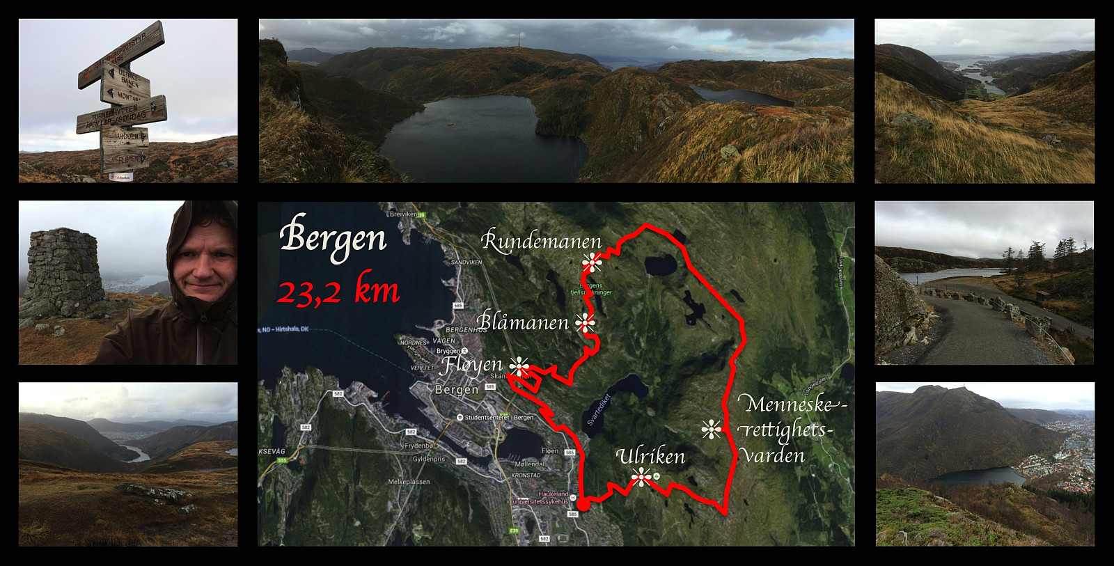 I've been working in the city of Bergen since September 2013, but I have not yet moved to Bergen. I usually go home (by plane) for the weekends unless I'm on call at the hospital where I'm working. During this particular week, however, my wife had come to Bergen to visit me instead, and we were therefore both in Bergen throughout the weekend. On Sunday I went for this 23 km long workout, where I climbed Mount Ulriken, and then followed a trail around the huge plateau that Ulriken is a part of, circumventing the valleys Isdalen, Hardbakkedalen and Våkendalen [The Norwegian word "dal" means valley]. The trail follows a mountain ridge that people in Bergen call Vidden . Finally, the trail takes you down into the pass that connects the valley of Våkendalen with the valley of Jordalen
Another Hike to Mount Ulriken
- Datum:
- 07.11.2015
- Tourcharakter:
- Wanderung
- Tourlänge:
- 1:55h
- Entfernung:
- 4,5km
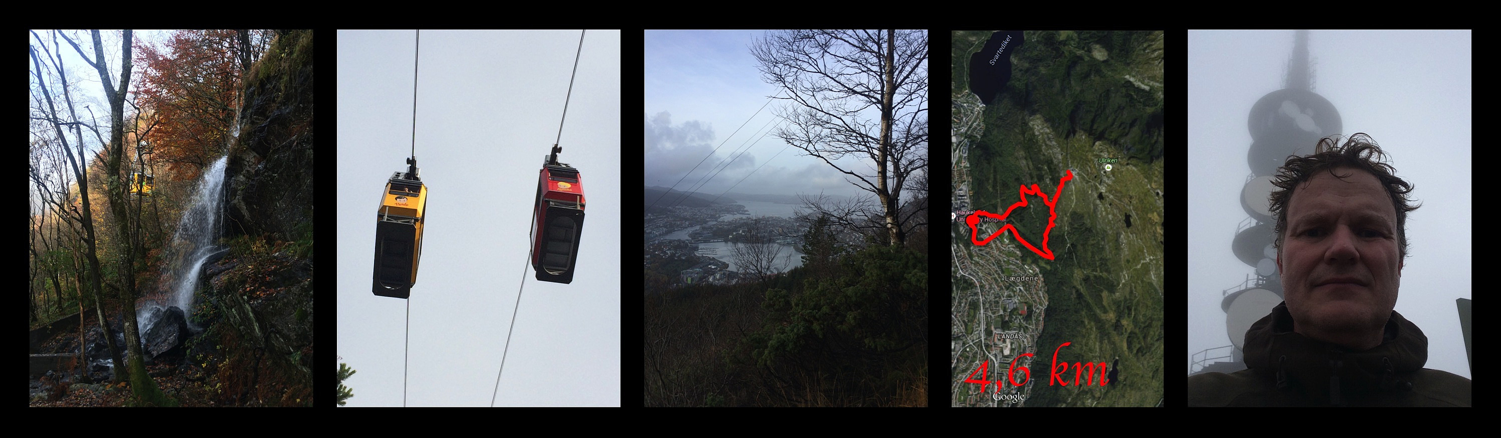 I've been working in the city of Bergen since 2013. I usually go home for the weekends, unless I'm on call. On this particular weekend I remained in Bergen, however, and so I decided to climb Mount Ulriken again to get some recreation after a busy week at work. There is a rather steep path through the forest beneath the cable car, which I followed up the mountain side. From about 400 m.a.m.s.l. there's suddenly no more forest, but the path continues up the mountain side, and then follows a little mountain ridge till you're almost on top of the mountain. The last 50 elevation meters before you reach the end station of the cable car is again a bit steep, but not in a manner that will cause any trouble for you if you're just a little bit experienced with mountain trekking. For the descent I followed >>>
Til Remmemstind opp midtryggen
- Datum:
- 17.10.2015
- Tourcharakter:
- Wanderung
- Tourlänge:
- 5:49h
- Entfernung:
- 13,2km
 Fra Remmemsdalen er det tre forskjellige fjellrygger som fører opp til toppen av Remmemstinden. Det er nordøstryggen, midtryggen og Brastadryggen. Mellom nordøstryggen og midtryggen ligger Remmemsvatnet (724 m.o.h.), og mellom midtryggen og Brastadryggen ligger Brastadvatnet (627 m.o.h.). Denne dagen hadde jeg og eldste sønnen bestemt oss for å prøve oss på å nå toppen via midtryggen. Vi hadde en gang tidligere forsøkt oss sånn halvhjertet på nordøstryggen, og funnet ut at den var i bratteste laget; men midtryggen mente vi burde være grei.
Vi la turen via Bjørnetua og Vardfjellet denne dagen, da vi tidligere hadde erfart at stien opp Heia kunne være litt vanskelig å finne helt nede ved Hellandsetra. Fra Vardfjellet fortsetter man bare videre oppover den fjellryggen man faktisk >>>
Fra Remmemsdalen er det tre forskjellige fjellrygger som fører opp til toppen av Remmemstinden. Det er nordøstryggen, midtryggen og Brastadryggen. Mellom nordøstryggen og midtryggen ligger Remmemsvatnet (724 m.o.h.), og mellom midtryggen og Brastadryggen ligger Brastadvatnet (627 m.o.h.). Denne dagen hadde jeg og eldste sønnen bestemt oss for å prøve oss på å nå toppen via midtryggen. Vi hadde en gang tidligere forsøkt oss sånn halvhjertet på nordøstryggen, og funnet ut at den var i bratteste laget; men midtryggen mente vi burde være grei.
Vi la turen via Bjørnetua og Vardfjellet denne dagen, da vi tidligere hadde erfart at stien opp Heia kunne være litt vanskelig å finne helt nede ved Hellandsetra. Fra Vardfjellet fortsetter man bare videre oppover den fjellryggen man faktisk >>>
Bjørnetua og Vardjellet
- Datum:
- 10.10.2015
- Tourcharakter:
- Wanderung
- Tourlänge:
- 4:23h
- Entfernung:
- 8,8km
 Dette var en tur søstra mi ønsket seg til fødselsdagen sin, og da var fjellene ovenfor Remmemsbukta noe vi hadde en akkurat passe nostaligsk tilknytning til. Vi vokste opp med farmor og farfar bosatt i Remmemsbukta, og pleide som barn ofte å besøke dem når vi hadde ferie. Den gangen var det langt mindre fokus på trening og almennhelse enn hva vi har i dag, og på fjelltur var det sjelden vi gikk lengre enn til den røde postkassa på trestammen ved Remmemsetra. Som barn hadde derfor ingen av oss vært hverken på Bjørnetua eller Vardfjellet, men jeg hadde vært på begge toppene noen uker før vi nå tok turen opp denne vakre høstdagen.
Vi betalte de 30 kronene i bompenger, og kjørte Hellandseterveien opp til parkeringsplassen i Remmemsdalen. Derfra la vi så ut til fots, og gikk først >>>
Dette var en tur søstra mi ønsket seg til fødselsdagen sin, og da var fjellene ovenfor Remmemsbukta noe vi hadde en akkurat passe nostaligsk tilknytning til. Vi vokste opp med farmor og farfar bosatt i Remmemsbukta, og pleide som barn ofte å besøke dem når vi hadde ferie. Den gangen var det langt mindre fokus på trening og almennhelse enn hva vi har i dag, og på fjelltur var det sjelden vi gikk lengre enn til den røde postkassa på trestammen ved Remmemsetra. Som barn hadde derfor ingen av oss vært hverken på Bjørnetua eller Vardfjellet, men jeg hadde vært på begge toppene noen uker før vi nå tok turen opp denne vakre høstdagen.
Vi betalte de 30 kronene i bompenger, og kjørte Hellandseterveien opp til parkeringsplassen i Remmemsdalen. Derfra la vi så ut til fots, og gikk først >>>
Climbing Mount Ulriken on a Beautiful Afternoon
- Datum:
- 05.10.2015
- Tourcharakter:
- Wanderung
- Tourlänge:
- 1:58h
- Entfernung:
- 5,2km
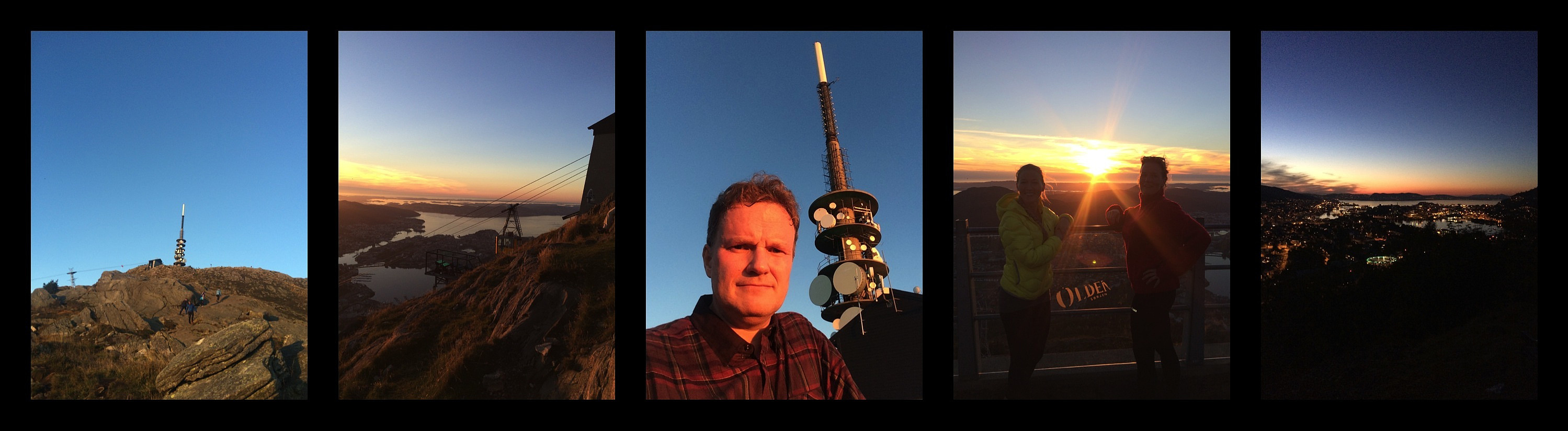 It feels quite liberating to climb mount Ulriken on monday afternoon/evening, when you've been on call and therefore confined to the hospital and your nearby apartment for the entire weekend. Bergen is a fantastic beautiful city at sunset and at twilight, by the way. And surprise, surprise, at the top of the mountain I encountered two of my colleagues (c'est une hôpital tres sportive..!).
