Archiv - Nach Datum
Archiv - Nach Aktivität
-
Andere Tour (1)
- Expedition (1)
-
Andere Wintertour (10)
- Schneeschuhtour (10)
- Fahrradtour (2)
- Fußtour (232)
-
Klettern (8)
- Alpinklettern (7)
- Mixed-Klettern (1)
-
Skitour (49)
- Randonnée/Telemark (49)


Gesammelte Listen
-
Romsdal ≥ 100m pf.
(135/301)
 44%
44% -
Sunnmøre ≥ 100m pf.
(79/531)
14%
-
Norges 1000 største fjell målt i primærfaktor
(53/1000)
5%

To Mount Slogen with my Two Daughters
- Datum:
- 30.07.2016
- Tourcharakter:
- Hochtour
- Tourlänge:
- 8:03h
- Entfernung:
- 8,8km
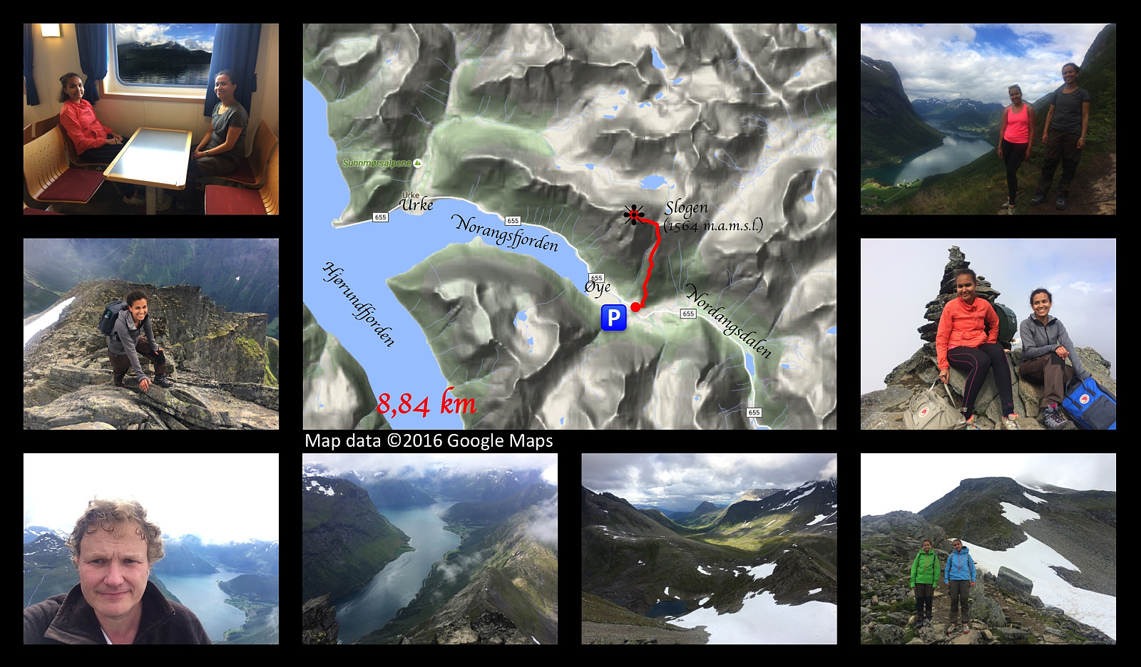 In order to get to Mount Slogen from where we live, you have to cross the fjord called Storfjorden [i.e. “The Large Fjord”], and so on this occasion I went by car with my two daughters to a place called Magerholm; from where we crossed the fjord by ferry, arriving at a headland called Ørsneset, not far from the village of Sykkylven. From Sykkylven we continued our drive to the village of Stranda, then on to the village of Hellesylt; and finally a few kilometres after we had passed Hellesylt, we took the road to the right, which took us down to a fjord called Nordangsfjorden, a side arm of the beautiful fjord of Hjørundfjorden.
We parked at a parking lot at a place called Øye, and immediately embarked upon our climb. The climb up Mount Slogen is quite steep all the way from the beginning >>>
In order to get to Mount Slogen from where we live, you have to cross the fjord called Storfjorden [i.e. “The Large Fjord”], and so on this occasion I went by car with my two daughters to a place called Magerholm; from where we crossed the fjord by ferry, arriving at a headland called Ørsneset, not far from the village of Sykkylven. From Sykkylven we continued our drive to the village of Stranda, then on to the village of Hellesylt; and finally a few kilometres after we had passed Hellesylt, we took the road to the right, which took us down to a fjord called Nordangsfjorden, a side arm of the beautiful fjord of Hjørundfjorden.
We parked at a parking lot at a place called Øye, and immediately embarked upon our climb. The climb up Mount Slogen is quite steep all the way from the beginning >>>
To Mount Urfjellet with my Son Dag
- Datum:
- 16.07.2016
- Tourcharakter:
- Wanderung
- Tourlänge:
- 3:25h
- Entfernung:
- 10,7km
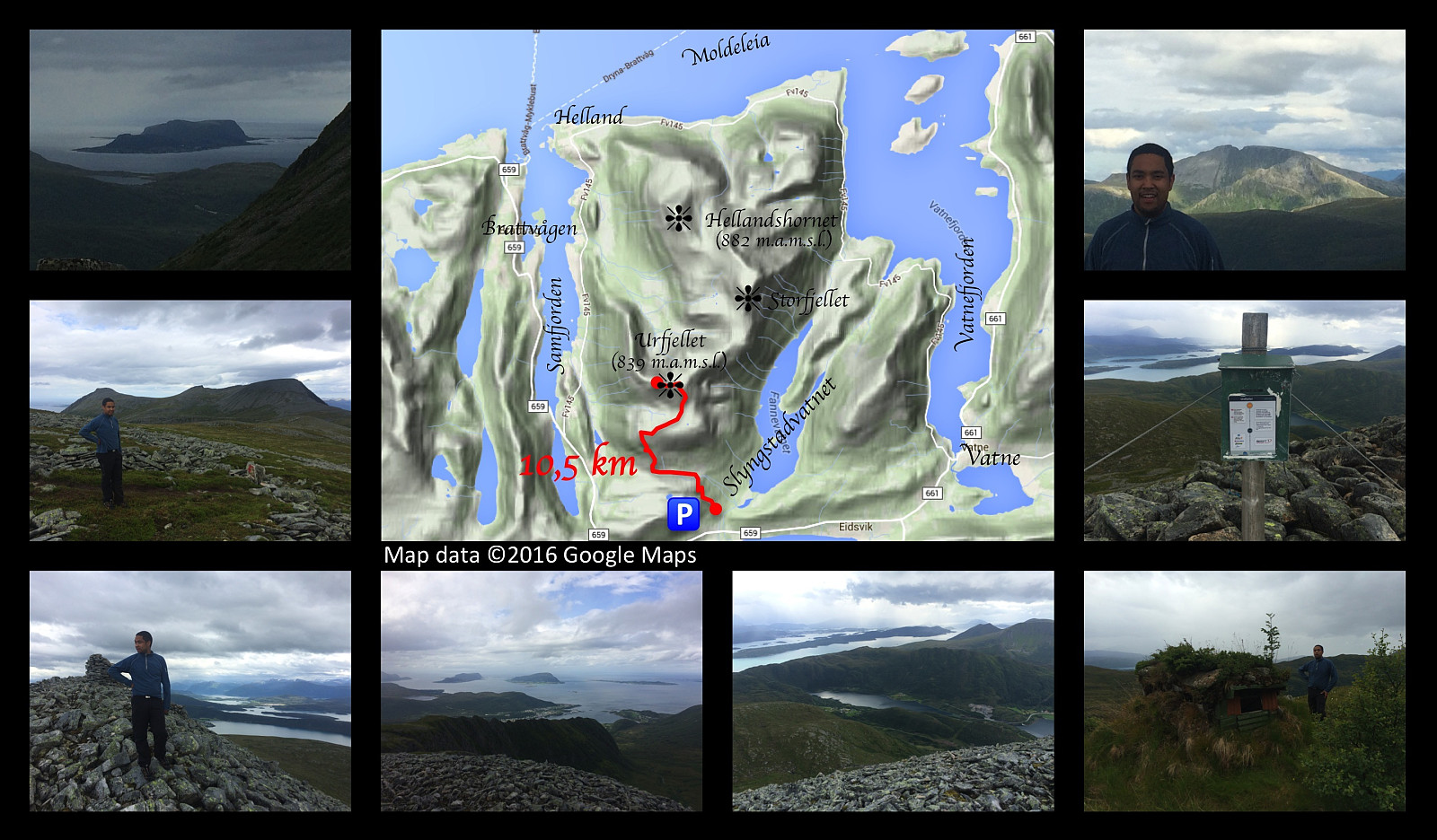 Just outside the little village of Slyngstad, you'll find an old road over Mount Remefjellet, and then down to the fjord called Samfjorden on the other side of the mountain (see map). This old road was once upon a time the main road to the village of Brattvåg. Later on, however, a new road was built, with a tunnel through the mountain; and the old road is now no longer being maintained, and it is now mainly used by tour walkers and mountain trekkers. Tour walkers are actually still using the entire length of the road to get from one side of the mountain to the other; whereas for the mountain trekkers about half of it has become the first leg of the trail up to Mount Urfjellet [839 m.a.m.s.l.] and Mount Storfjellet [950 m.a.m.s.l.].
My son and I parked our car at a little parking lot at Slyngstad, >>>
Just outside the little village of Slyngstad, you'll find an old road over Mount Remefjellet, and then down to the fjord called Samfjorden on the other side of the mountain (see map). This old road was once upon a time the main road to the village of Brattvåg. Later on, however, a new road was built, with a tunnel through the mountain; and the old road is now no longer being maintained, and it is now mainly used by tour walkers and mountain trekkers. Tour walkers are actually still using the entire length of the road to get from one side of the mountain to the other; whereas for the mountain trekkers about half of it has become the first leg of the trail up to Mount Urfjellet [839 m.a.m.s.l.] and Mount Storfjellet [950 m.a.m.s.l.].
My son and I parked our car at a little parking lot at Slyngstad, >>>
Visiting Mount Lauparen and Mount Grytavasstinden
- Datum:
- 10.07.2016
- Tourcharakter:
- Hochtour
- Tourlänge:
- 9:00h
- Entfernung:
- 19,5km
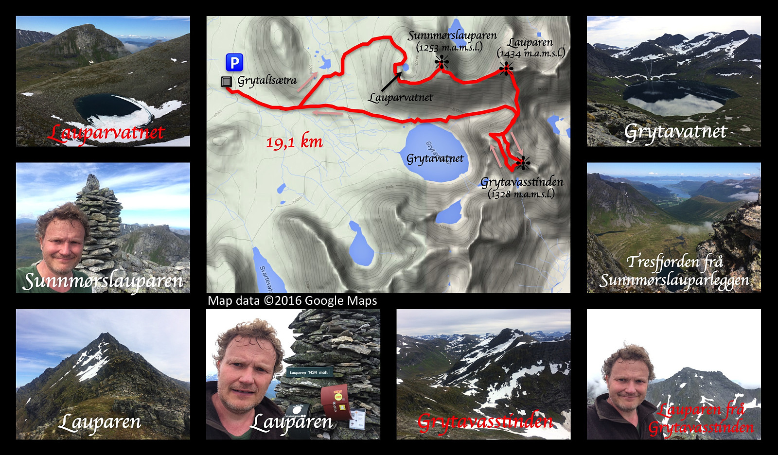 On this day I climbed up to the summits of Mount Lauparen and Mount Grytavasstinden. I started out from the parking lot at Grytalisetra (see map), and followed the regular trail for climbing these mountains for about 1,5 km, and then I took left towards the foot of Mount Sunnmørslauparen, which isn't actually a real mountain by itself, but rather a huge westward going ridge on Mount Lauparen. I climbed up the mountain side and at about 950 m.a.m.s.l., I reached a plateau on which a lake called Lake Lauparvatnet is located. From the Lake I continued up a huge mountain ridge to a new plateau, where you actually find the spot that is called Sunnmørslauparen [1254 m.a.m.s.l.] here on Peakbook. From there i continued up another mountain ridge towards the summit of Lauparen. This ridge got steeper >>>
Hiking to Mount Blåskjerdingen with my Sister
- Datum:
- 02.07.2016
- Tourcharakter:
- Wanderung
- Tourlänge:
- 5:04h
- Entfernung:
- 9,8km
 My sister is living in another part of our beautiful country, but whenever she's visiting our part of the country, she frequently asks me to take her on some mountain trip. Now, I don't dare to take her on the steepest and most challenging climbs, so when she asks me for that, I say to her, just as when we were kids: "No, you're too young...!" Nevertheless, I considered that she would do quite well with Mount Blåskjærdingen, so on this day we agreed to go there. Now, Mount Blåskjerdingen has two summits, with a characteristic V-shaped cleft in between them; and this actually makes it quite easy to spot the mountain even from afar.
We parked our car at a parking lot in Vatnedalen Valley (see map). Her on Peakbook this parking lot has actually been named after the mountain, i.e. you'll >>>
My sister is living in another part of our beautiful country, but whenever she's visiting our part of the country, she frequently asks me to take her on some mountain trip. Now, I don't dare to take her on the steepest and most challenging climbs, so when she asks me for that, I say to her, just as when we were kids: "No, you're too young...!" Nevertheless, I considered that she would do quite well with Mount Blåskjærdingen, so on this day we agreed to go there. Now, Mount Blåskjerdingen has two summits, with a characteristic V-shaped cleft in between them; and this actually makes it quite easy to spot the mountain even from afar.
We parked our car at a parking lot in Vatnedalen Valley (see map). Her on Peakbook this parking lot has actually been named after the mountain, i.e. you'll >>>
