Archiv - Nach Datum
Archiv - Nach Aktivität
-
Andere Tour (1)
- Kayaking (1)
-
Andere Wintertour (4)
- Schneeschuhtour (4)
-
Fahrradtour (137)
- Fahrradtour Straße (9)
- Fahrradtour gemischt (51)
-
Fußtour (740)
- Bergtour (363)
- Jogging (18)
- Spaziergang (89)
- Wanderung (270)
-
Skitour (4)
- Tourenskilauf (4)
Archiv - Nach Geografie
Peakbookfreunde


Gesammelte Listen
-
Bergen ≥ 50m pf. og ≥ 100 m.o.h.
(87/89)
 97%
97% -
Most dominating tops of the Bergen peninsula
(68/75)
90%
-
Utvalgte topper og turmål i Bergen
(316/350)
90%
-
Alle topper i Bergen
(357/398)
89%
-
Opptur Bergen
(100/113)
88%
-
De syv fjell rundt Bergen
(6/7)
85%
-
Sund ≥ 50m pf.
(14/18)
77%
-
Os ≥ 50m pf.
(25/34)
73%
-
Søyler (fastmerker) i Bergen
(68/100)
68%
-
Fjell ≥ 50m pf.
(21/32)
65%

Møsnuken
- Datum:
- 17.04.2016
- Tourcharakter:
- Bergtour
- Tourlänge:
- 5:00h
- Entfernung:
- 11,8km
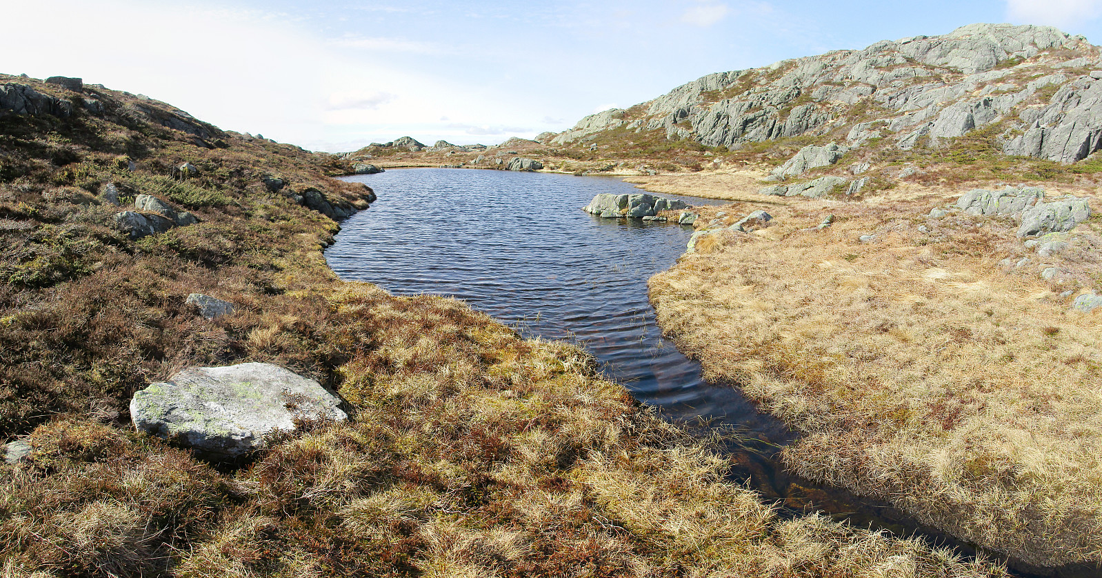 We took road E39 southwards from Bergen, passing by Kalandsvatnet and driving all the way to Ulven (near Os), where we turned left (right next to a gas station), finding the small road connecting to Tyssdal. On the other side of Oselva, near the point, where Tyssdalselva is coming down from Møsnuken, we found a parking place and started to hike from there. Since we wished to start with Borgafjellet, this time, we first tried to connect to the gravel road that connects Tyssdal with Os (right next to Oselva, on its eastern side). We could have done this "the easy way" :-) -- instead, we walked up to the houses on the hillside south of Tyssdal. Up there, we understood that we were too high and descended the few meters down to the gravel road through the forest. Following the gravel >>>
Tveitafjellet
- Datum:
- 16.04.2016
- Tourcharakter:
- Bergtour
- Tourlänge:
- 2:00h
- Entfernung:
- 6,3km
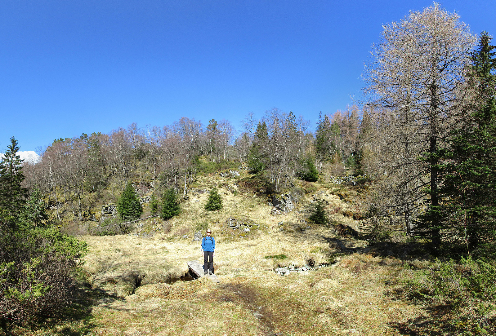 We were driving to Osterøy near Bergen and on Osterøy further, first to Lonevåg and then to Hosanger. There, we turned right (into the direction of Kossdalen, actually!), but continued a small road upwards on the Eastern side of the valley until we came to the junction, where one road continues to the left (up to Åsheim) and the other goes to the right (up to Tveiten). From there, we started hiking, first following the road up to Åsheim. The path up to Åsheimveten leaves from the road to the right (near the houses of Åsheim)---it's good to not follow the temptation of hiking along the path to Tveitafjellet, which is well marked a little underneath the houses. Once on the right path, it's quick and straight-forward to hike up Åsheimveten, which offers fantastic views of Osterfjorden >>>
Indrafjellet from Liaskjæret
- Datum:
- 09.04.2016
- Tourcharakter:
- Bergtour
- Tourlänge:
- 3:30h
- Entfernung:
- 8,2km
 We drove from Bergen to Sotra, turning left before entering the tunnel and driving south to Liaskjæret on the eastside of the island. We parked near Liaskjervegen 182, i.e., very close to the point at the street, where the bus turns around. We followed the street southwards, basically to its end---very near to a small harbor for private boats. We went around the last houses and came soon to a small bay (called Nordra Skagavika). From there, we followed a very simple path that leads up to a small lake (Røssevikvatnet). We continued on the western side of this small lake, approaching Hansafjellet. It's straight-forward to hike there, even though we could not see any paths (occasionally, it's wet, yes). It was good to change over to Hansafjellet on its northern end---ascending to this >>>
Knappen
- Datum:
- 20.03.2016
- Tourcharakter:
- Bergtour
- Tourlänge:
- 1:30h
- Entfernung:
- 5,2km
 We started from Varden, Einerhaugen, crossed Bjørgeveien and ascended along Vassteigen towards Knappen. This time, however, we walked around Knappetjørna, first, before ascending to the "top" of Knappen. Afterwards, we basically took the same path back.
See also the related FB-page Hiking around Bergen, Norway .
Petter Bjørstad has a useful page about Knappen .
We started from Varden, Einerhaugen, crossed Bjørgeveien and ascended along Vassteigen towards Knappen. This time, however, we walked around Knappetjørna, first, before ascending to the "top" of Knappen. Afterwards, we basically took the same path back.
See also the related FB-page Hiking around Bergen, Norway .
Petter Bjørstad has a useful page about Knappen .
Langrinden (Ulriken)
- Datum:
- 17.03.2016
- Tourcharakter:
- Bergtour
- Tourlänge:
- 1:00h
- Entfernung:
- 2,6km
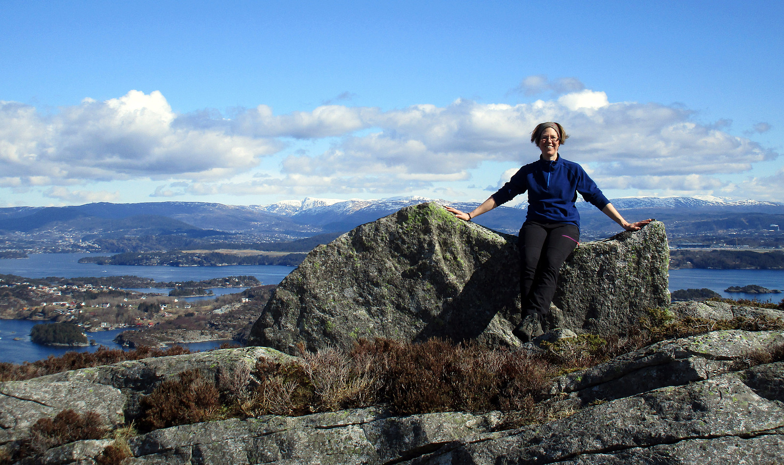
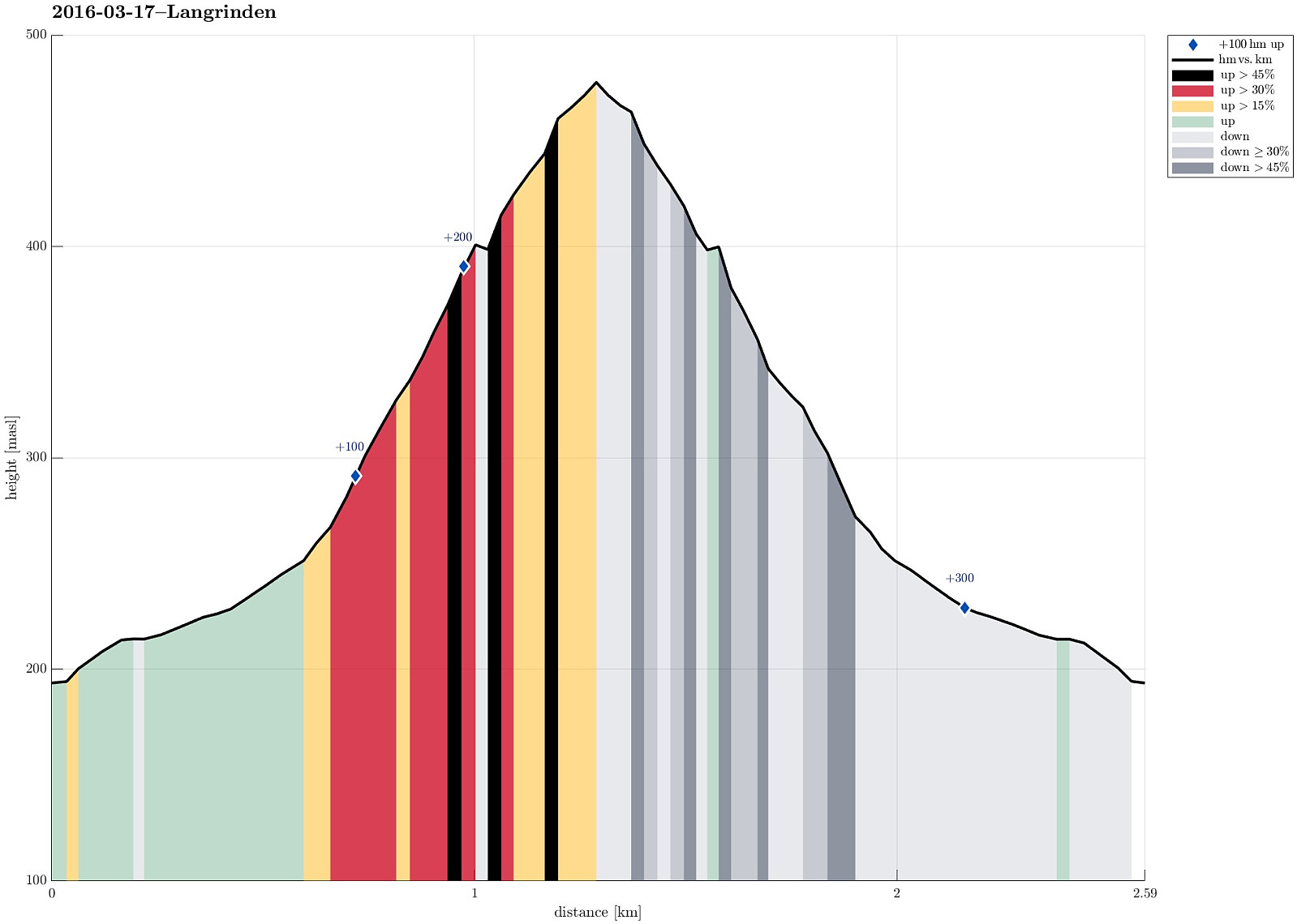 We started from Haggardshaugen (right above Montana Vandrehjem), followed Skiveien / Johan Blytts vei up to the point, where a little bridge crosses over a small stream. Instead of crossing the bridge, we turned left and followed the ridge up (first towards the power line mast, then along the ridge further up). This is a very nice way up to Ulriken. Since time was late, already, and it started to get dark (also, we reached the clouds at a point which is marked with Langrinden), we decided to not ascend all the way up to Ulriken, but turn around and go back, instead. All in all, a short and nice evening hike, right after work! :-)
Selected photos are available as Google photo album .
See also the related FB-page Hiking around Bergen, Norway .
Web page WestCoastPeaks.com provides useful information about Haugavarden, Ulriken, Storfjellet, and Landåsfjellet
and also Petter Bjørstad has a useful page about Ulriken .
Web page UT.no from the Norwegian Trekking Association recommends the same hike up Ulriken .
On Bergentopp 200 there is a page (in Norwegian) >>>
We started from Haggardshaugen (right above Montana Vandrehjem), followed Skiveien / Johan Blytts vei up to the point, where a little bridge crosses over a small stream. Instead of crossing the bridge, we turned left and followed the ridge up (first towards the power line mast, then along the ridge further up). This is a very nice way up to Ulriken. Since time was late, already, and it started to get dark (also, we reached the clouds at a point which is marked with Langrinden), we decided to not ascend all the way up to Ulriken, but turn around and go back, instead. All in all, a short and nice evening hike, right after work! :-)
Selected photos are available as Google photo album .
See also the related FB-page Hiking around Bergen, Norway .
Web page WestCoastPeaks.com provides useful information about Haugavarden, Ulriken, Storfjellet, and Landåsfjellet
and also Petter Bjørstad has a useful page about Ulriken .
Web page UT.no from the Norwegian Trekking Association recommends the same hike up Ulriken .
On Bergentopp 200 there is a page (in Norwegian) >>>
Alteret
- Datum:
- 13.03.2016
- Tourcharakter:
- Bergtour
- Tourlänge:
- 1:45h
- Entfernung:
- 3,5km
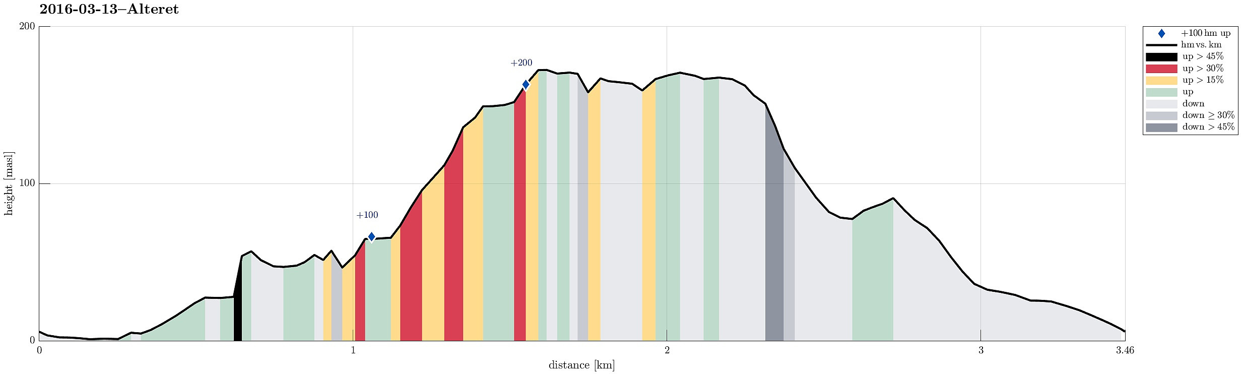 We parked in Haganes, almost at sea level, and near this little park, which they have set up close to the sea. Actually, before starting our hike, we first inspected this little park, which is there in Haganes kind of unexpected! :-) We then walked along the sea for a few meters (on the eastern side of the bay, vis-a-vis Notaneset), before we connected to another small road, serving a number of new houses there. Behind the houses on the eastern side of this road, we eventually found a narrow path, leading in southeastern direction (as we had planned). We managed to get around and up the first cliff, following this simple path, and crossed over, then, along a comparably wet path, to the next cliff. Climbing a few steps up and around, we ended up at the other side to this small cliff and >>>
Damsgårdsfjellet from Laksevåg
- Datum:
- 05.03.2016
- Tourcharakter:
- Bergtour
- Tourlänge:
- 2:00h
- Entfernung:
- 6,8km
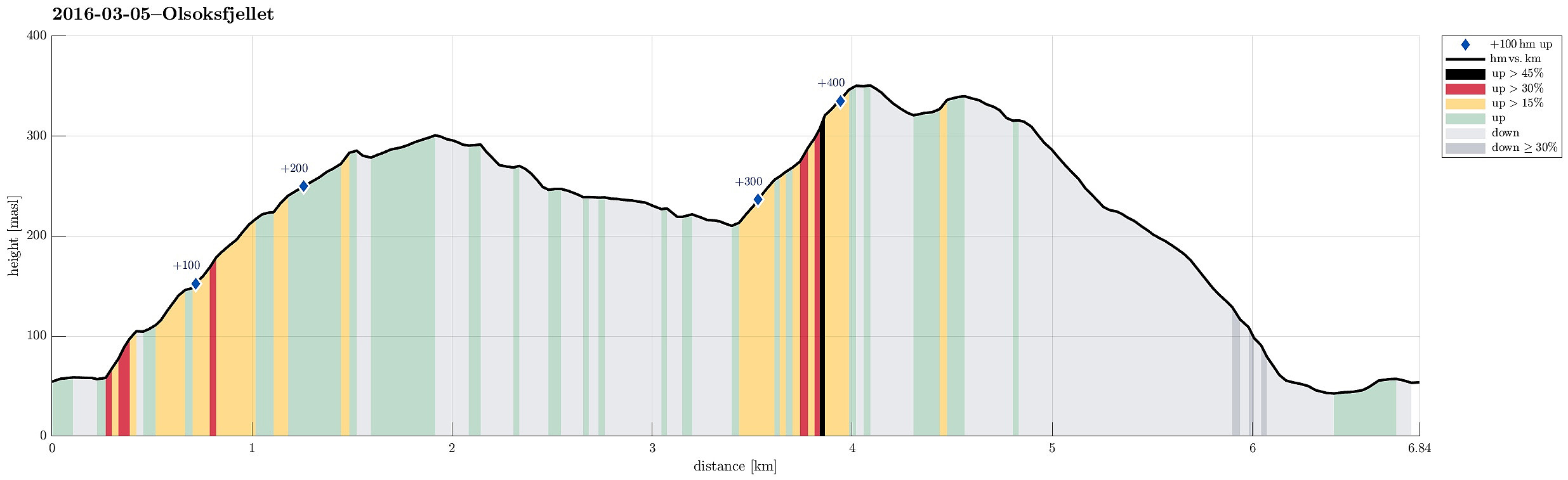 We parked near Holen school, at the northern part of Laksevåg. Following Øvre Holen, first, for a few meters (towards northwest), we found the trail head, from where we ascende do Rundetoppen and Holefjellet first (along a nice ridge with views over Laksvåg and towards Lyderhorn). We then descended into the valley (to the southwest from Holefjellet), in which we met another path up from Laksevåg (from Nygårdslien). From there, we continued towards Espedalen, right underneath Olsokfjellet. At the upper end of Nordnæsdalen, where the is a little hut and a simple soccer field, we crossed over to the side of Olsokfjellet and ascended to the top via its southern ridge. From Olsokfjellet, we continued to Damsgårdsfjellet and descended from there via its northern ridge towards Laksevåg. >>>
Skiing Livarden
- Datum:
- 28.02.2016
- Tourcharakter:
- Tourenskilauf
- Tourlänge:
- 3:15h
- Entfernung:
- 10,8km
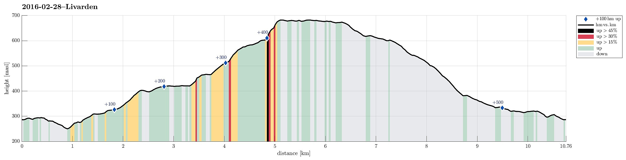 We parked near Fanahytten, went a few steps, passing Fanahytten, before we crossed over to the other side (Totlandsfjellet), walking down the road for a few meters. Parallel to Totlandsvegen as well as Totlandsfjellet, we ascended in the direction of Livarden, following a track that others had used before us (not too many, but some). Instead of skiing on the top of Totlandsfjellet, we proceeded below it, somehow on middle-height between the valley and the mountain ridge. At the point, where we switched over from Totlandsfjellet to Livarden, basically, we ascended through a narrow, little valley, called Gråsmoget. From there, we followed the track, ascending step by step to the height of Livarden. Particularly this stretch, from Gråsmoget up to the top of Livarden, was especially nice---winter >>>
Around Jordalen
- Datum:
- 13.02.2016
- Tourcharakter:
- Bergtour
- Tourlänge:
- 6:45h
- Entfernung:
- 19,4km
 Having delivered our son in Tertnes, we parked very near at Storbotn (where Den Trondhjemske Postvegen comes by). We walked first along Den Trondhjemske Postvegen towards northeast, before we departed to the left and up Eikhøyen (and from there to the top of Rollandsoksen---not really a big hill, but with a nice view over Tertnes!). From there, we hiked down to Kolåsen, from where we took Rollandsvegen up to where a path leaves, leading to the southeast. We ascended to the saddle (near Steindalen), right below Litlanipa, from there. Instead of following the main route (via Stornipa and Nukane to Storsåta), we crossed the saddle to the other side, descending into Traudalen. Near two masts of the power line which runs through this valley, we crossed Nedgardselva and continued (along the >>>
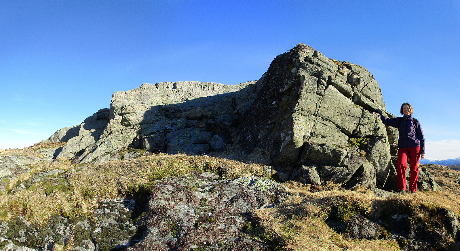
Around Toppe via Toppenipa and Geitanuken
- Datum:
- 06.02.2016
- Tourcharakter:
- Bergtour
- Tourlänge:
- 2:15h
- Entfernung:
- 6,7km
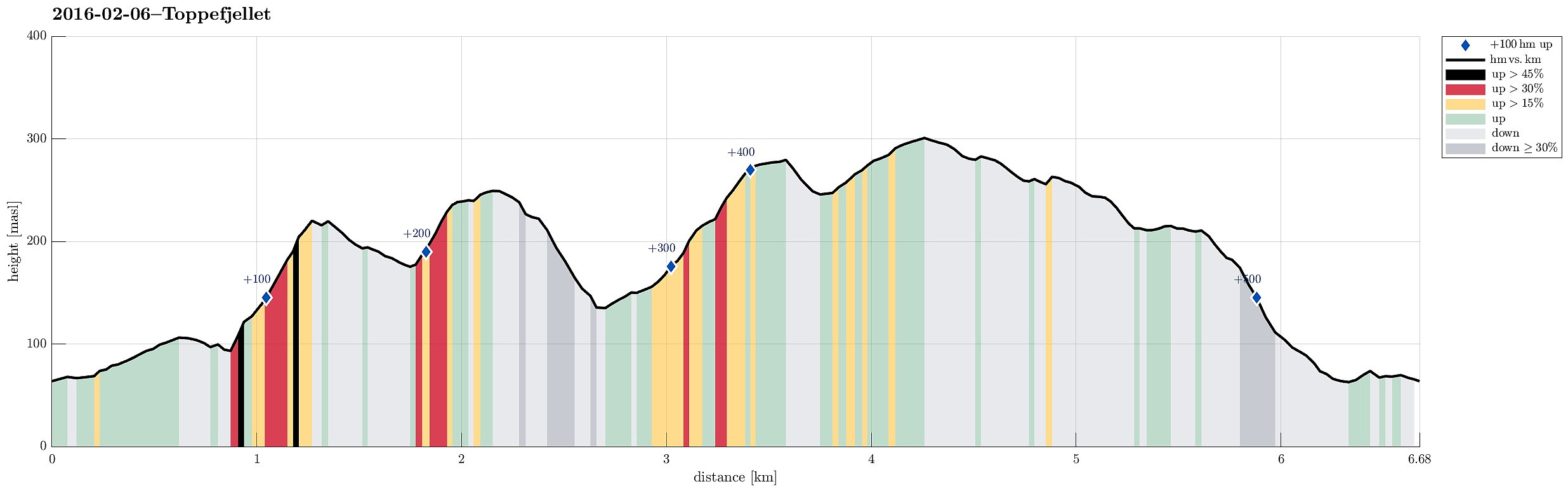 We took the road that leads from Åsane to Salhus and turned left towards Toppe shortly before coming near to Salhus (near Hitland) and passed through a short tunnel right afterwards. Next, we turned left and parked near a commercial area in the middle of Nordre Toppe. From there, we first walked along Toppevegen in northeastern direction until we ended up right above the tunnel that we had taken before (we could have taken a small side-road already earlier, leading directly to the trail head above, but we thought that it only connected to a private house there). Instead we ascended over some green from right above the tunnel and found the trail head also this way, easily. Then we continued upwards towards the top of Toppenipa, following a very nice path that leads upwards steeply. On >>>
