Archiv - Nach Datum
Archiv - Nach Aktivität
-
Andere Tour (1)
- Kayaking (1)
-
Andere Wintertour (4)
- Schneeschuhtour (4)
-
Fahrradtour (137)
- Fahrradtour Straße (9)
- Fahrradtour gemischt (51)
-
Fußtour (740)
- Bergtour (363)
- Jogging (18)
- Spaziergang (89)
- Wanderung (270)
-
Skitour (4)
- Tourenskilauf (4)
Archiv - Nach Geografie
Peakbookfreunde


Gesammelte Listen
-
Bergen ≥ 50m pf. og ≥ 100 m.o.h.
(87/89)
 97%
97% -
Most dominating tops of the Bergen peninsula
(68/75)
90%
-
Utvalgte topper og turmål i Bergen
(316/350)
90%
-
Alle topper i Bergen
(357/398)
89%
-
Opptur Bergen
(100/113)
88%
-
De syv fjell rundt Bergen
(6/7)
85%
-
Sund ≥ 50m pf.
(14/18)
77%
-
Os ≥ 50m pf.
(25/34)
73%
-
Søyler (fastmerker) i Bergen
(68/100)
68%
-
Fjell ≥ 50m pf.
(21/32)
65%

Rindafjellet from Gåssand (wow!)
- Datum:
- 21.05.2023
- Tourcharakter:
- Wanderung
- Tourlänge:
- 8:00h
- Entfernung:
- 17,0km
 We expected a nice Sunday and headed out for a special "project": Rindafjellet from Gåssand! This clearly became a bit of an adventure and (quite) a bit of a challenge, also. It may be good to read the following before possibly retracing our hiking track (the hike was very nice, yes, but also a bit long and very steep up to Rindafjellet!).
We drove south from Bergen (along E39 into the direction of Os) and took the small road that leads to Gåssand, after all. Before actually coming to the south end of Ytsta Raudlivatnet, however, we parked at the relatively large parking spot near Hatlelia. From there, we then first walked further along Gåssandvegen, crossing Nordelva north of Gåssand. At the other side of the bridge, we turned left and followed a track across Nauslia that >>>
We expected a nice Sunday and headed out for a special "project": Rindafjellet from Gåssand! This clearly became a bit of an adventure and (quite) a bit of a challenge, also. It may be good to read the following before possibly retracing our hiking track (the hike was very nice, yes, but also a bit long and very steep up to Rindafjellet!).
We drove south from Bergen (along E39 into the direction of Os) and took the small road that leads to Gåssand, after all. Before actually coming to the south end of Ytsta Raudlivatnet, however, we parked at the relatively large parking spot near Hatlelia. From there, we then first walked further along Gåssandvegen, crossing Nordelva north of Gåssand. At the other side of the bridge, we turned left and followed a track across Nauslia that >>>
Ankerhytten from Sandviken
- Datum:
- 18.05.2023
- Tourcharakter:
- Wanderung
- Tourlänge:
- 4:00h
- Entfernung:
- 11,1km
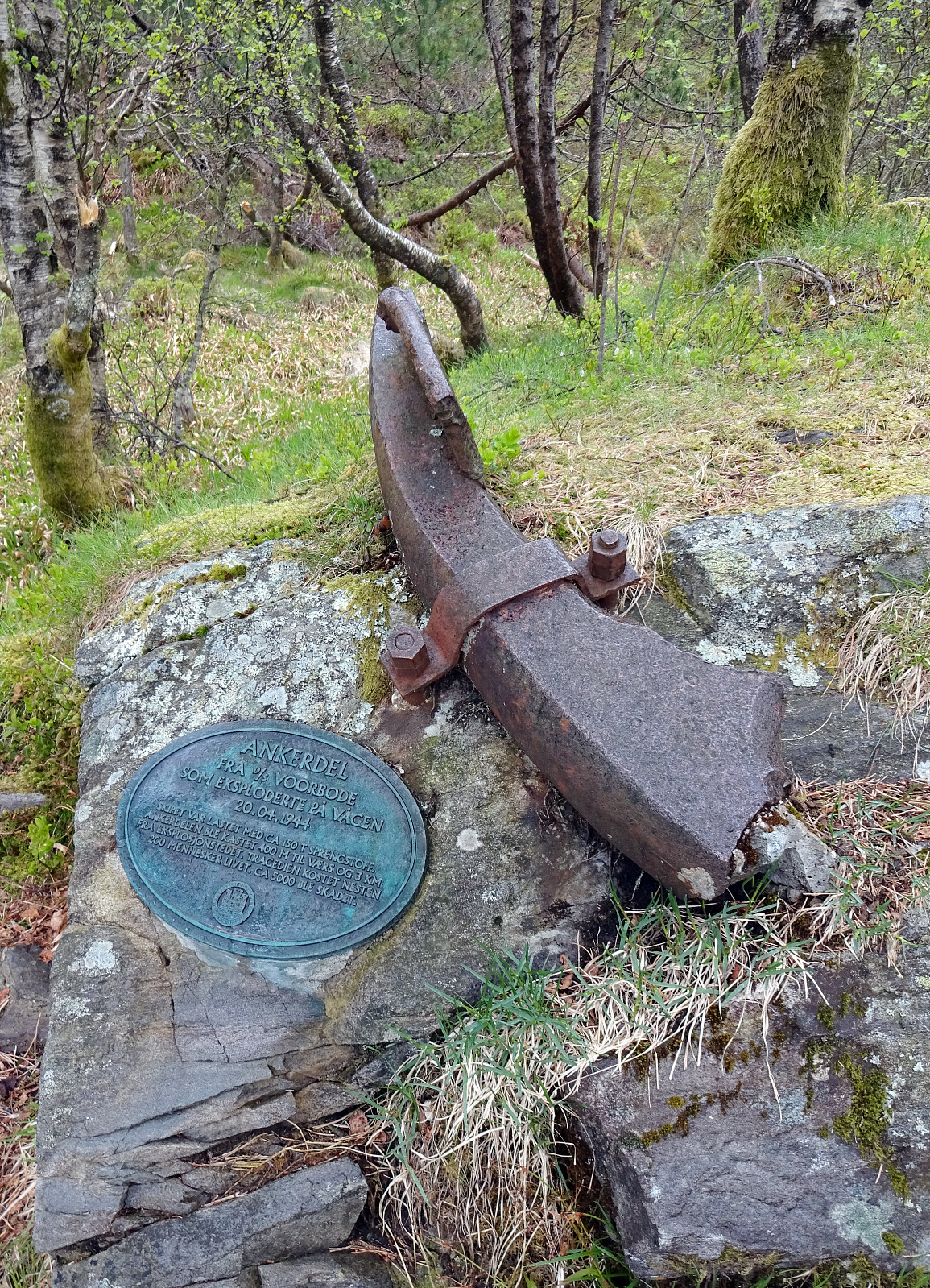 We somehow decided to go a round near Bergen and thus took the bus to Sandviken. After first walking up to Fjellveien, we continued along it to get to Permisjonsstien. This brought us up to Sandviksbatteriet, where we enjoyed the views over Byfjorden. Next on the agenda was to get over to Munkebotn, cross over the stream that runs out of Munkebotsvatnet towards the north, and take the trail up to cabin Ravneberg. This trail is actually quite steep (but nice and straight-forward to hike up), offering some nice views along it. Continuing along the trail, we then passed by (closed) Sandvikshytten, before heading further upwards into the direction of Kvitebjørnen. Instead of hiking all the way to the top of Kvitebjørnen, however, we then followed a lower trail that was supposed to bring >>>
Erdalsvarden from Bratland (or so)
- Datum:
- 13.05.2023
- Tourcharakter:
- Wanderung
- Tourlänge:
- 4:30h
- Entfernung:
- 12,2km
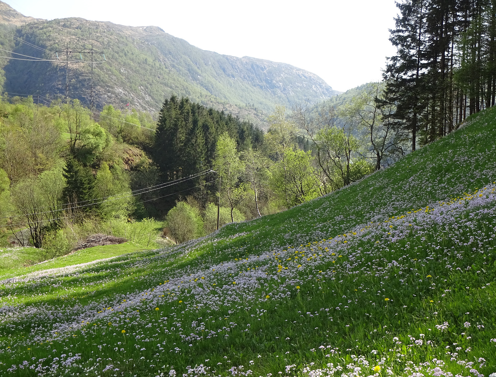 We picked up an older plan to visit Erdalsvarden from Bratland and drove past Grimevatnet to the south of Søylevatnet (along the main road to Arna). We parked where on also can take a trail (in southern direction) to get up to Furedalen. Instead, however, we headed (at large) in northward direction, passing Søylevatnet in its east. We then continued along the ridge that extends from Borgnyhaugen (in the southwest) to Krunhaugen (in the northeast). From there, we followed (for a short stretch) the road up to Øvre Bratland, before turning left at house 146 and then walking along the old postal route between Bergen and Christiania (nowadays Oslo). This brought us to the saddle where one could then continue downwards again (towards Erdalen in southwestern direction). There, we turned right >>>
Brøknipa from Båtaleitet, back via Borgasærtra
- Datum:
- 12.05.2023
- Tourcharakter:
- Wanderung
- Tourlänge:
- 6:00h
- Entfernung:
- 8,9km
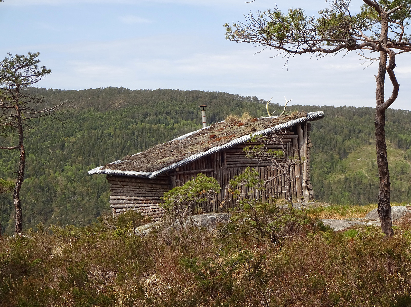
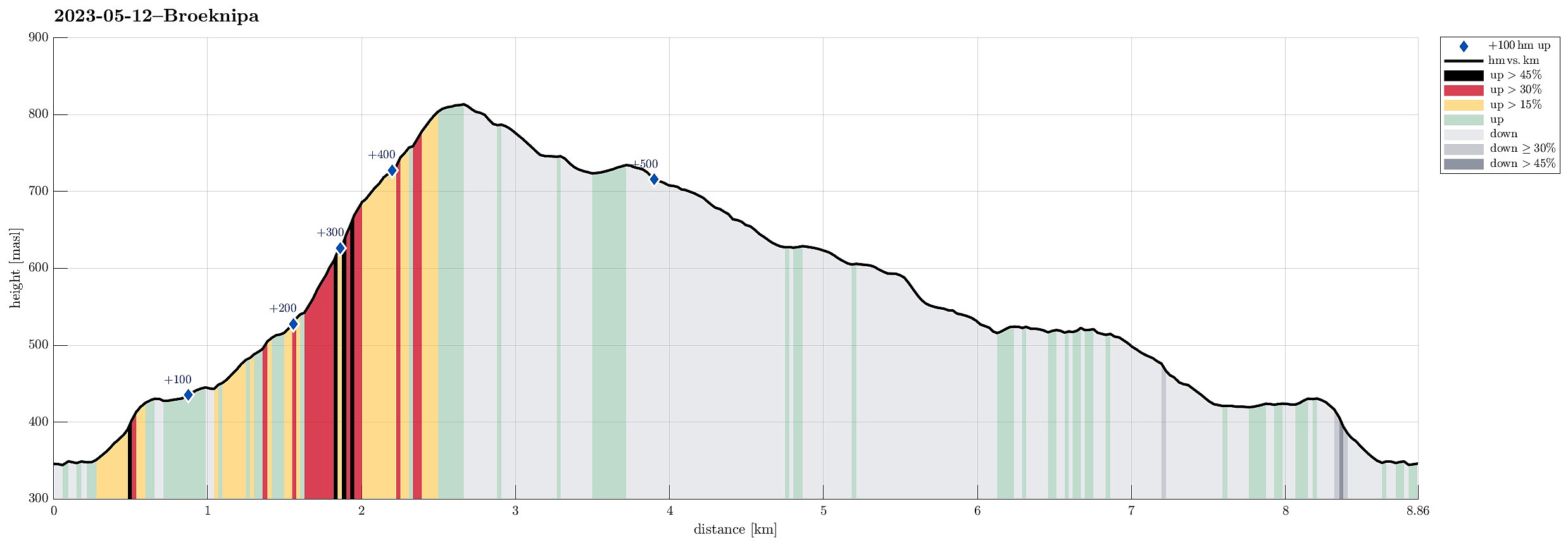 We had the afternoon of this Friday at our disposal and the weather was looking OK. :-) To combine some mountain impressions with such of the fjords, we headed for Brøknipa on Osterøy, starting from Båtaleitet parking at about 350mosl. After driving to Osterøy via the bridge and then continuing further (along Sørfjorden) towards Bruvik, we headed up to the saddle and parked at Båtaleitet parking. Looking up to Brøknipa from there, we recognized that there was still quite a bit of snow left on the northern flank. We agreed to giving it a try, while being ready to turn around whenever anyone of us would feel like it. We followed the main trail that passes by Varmavatnet at about 425mosl. Also the following 100 height meters (in southern direction) were still easy and without much >>>
Høgstefjellet, Tellevikafjellet, and Nordgardsfjellet
- Datum:
- 01.05.2023
- Tourcharakter:
- Wanderung
- Tourlänge:
- 2:30h
- Entfernung:
- 6,8km
 We were up to a medium-long hike and decided to do the round around Baugtveitstemma, including Høgstefjellet, Tellevikafjellet, and Nordgardsfjellet. After driving to Åsane, first, we then continued into the direction of Salhus, turning right at Hitland and entering the narrow road up to Baugtveit. Before actually getting all the way up to Baugtveit, we found a parking place at the parking slot for hikers (Håkonsplass). To get up to Høgstefjellet, we headed into southeastern direction, first. Instead of following the trail in the southwest of Furbudalen, we aimed at the ridge in the northeast of this trail, leading up to Baugtveitgotene. Even though we could not find any trail up this ridge, ascending it was still well doable (there are a few slightly steeper sections -- nothing that >>>
Bjørnaneset in Arboretet
- Datum:
- 29.04.2023
- Tourcharakter:
- Spaziergang
- Tourlänge:
- 2:00h
- Entfernung:
- 4,1km
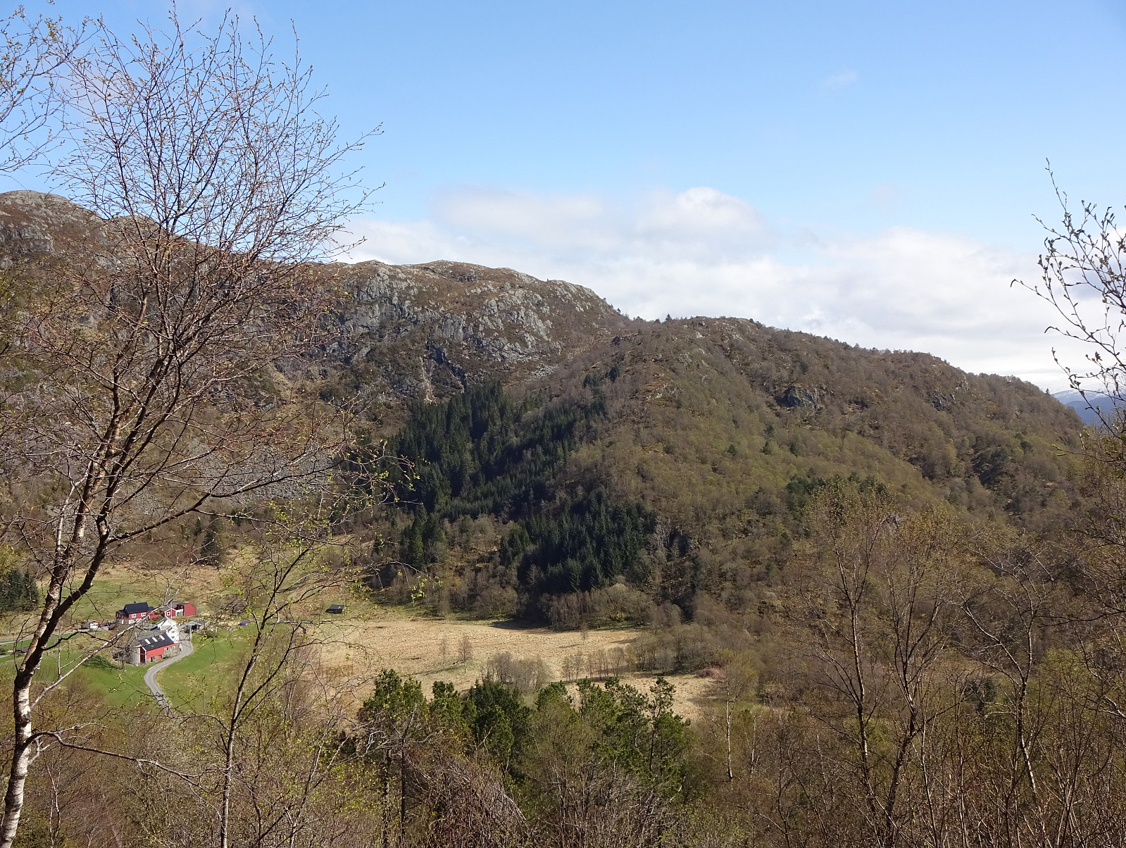
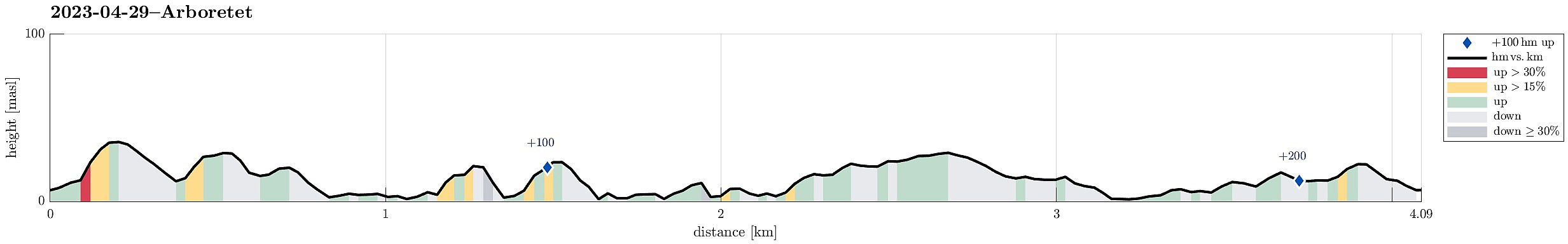 With some mixed weather prediction and a few other duties to do on this Saturday, we decided to "just" explore Arboretet in Milde a little further. We parked at the parking lot in the northwest of Arboretet and started our walk along the main gravel road. Only a few meters into it, however, we decided that we rather were up for some exploration and deviated to the south, up Gravåsen. From there, we then connected to Søre Vasshaugen, before then heading in a more northern direction. Near Mørkevatnet, we crossed the gravel road and continued on the western side of this small lake. In the north of it, we then found a convenient way to get over to the other, northeastern side. Already near Vestrepollen there, we continued into the direction of Bjørnaneset, following the shoreline >>>
Slettegga, Austefjellet, and Hausdalshorgi
- Datum:
- 22.04.2023
- Tourcharakter:
- Wanderung
- Tourlänge:
- 4:30h
- Entfernung:
- 11,1km
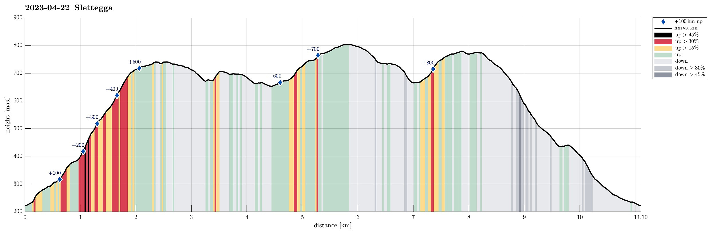 It looked like a wonderful spring day and we had a couple of hours. Since we had talked about Slettegga, already, we decided to try a new ascent to Slettegga -- via its southern ridge (up from Bjørnastølen). We drove into the valley of Bontveit (up from Kalandsvatnet) and over the saddle at the high end of the valley and further onto Øvstebøvegen. Near the low point of this road, before crossing over the stream that comes down from the north, we parked and started our hike. Near the bridge over the stream, we left the road to the left and ascended (quite steeply) up Lurabakken. After stepping through a few trees at about 260masl, we continued along a simple trail that leads northwards on the western side of the stream (in parallel to the stream). At about 315masl, we then crossed >>>
Stongfjellet and Skolmen
- Datum:
- 15.04.2023
- Tourcharakter:
- Wanderung
- Tourlänge:
- 4:30h
- Entfernung:
- 10,0km
 We first had considered Høgafjellet on Osterøy, but since we expected -- probably for good reasons -- quite a bit of snow on Høgafjellet, we eventually decided against Høgafjellet. Since we already thought about Osterøy, we chose Stongfjellet, instead. To get there, we drove to Osterøy (via the bridge to Osterøy), continuing through the tunnel on Osterøyvegen. At Gongerinden, we left Osterøyvegen, heading towards Gjerstad on Gjerstadvegen. Once through Gjerstad (and crossing over the stream), we continued via Solbjørg and Solbjørgsdalen. We then took Hovdavegen, passing by Låstadvatnet in its south and continuing further upwards in southeastern direction. Very close to the saddle, before reaching Hovdo at the end of the road, we parked right next to the trail-head. From Hovdavegen, >>>
Nordra Såta, Tyssdalsfjellet, and Borgafjellet
- Datum:
- 26.03.2023
- Tourcharakter:
- Wanderung
- Tourlänge:
- 4:00h
- Entfernung:
- 11,4km
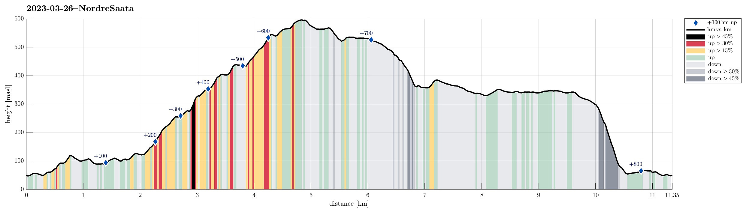 For a longer time, we had considered to visit Nordra Såta in the west of Tyssdalsfjellet (and Møsnuken). To do that, we drove to the parking spot at the lower end of Tyssdalen east of Tyssdalsvatnet (northeast of Ulven). Instead of following the main trail (up through Tyssdalen), we headed north (or even northwest) after crossing Tyssdalselva. We first followed the road (Tøsdalsvegen) for a short stretch until we crossed another minor stream there. There, in the south of Lyhaugen, we left the road and ascended first to a small hill south of Lyhaugen (with a post of a power line up there). It was a bit steep to get up there and one may wonder what it's worth this effort (or any, actually). :-) We then continued to Lyhaugen (also a bit steep, but also without actual problems). From >>>
Førdesveten from Vorland
- Datum:
- 18.03.2023
- Tourcharakter:
- Wanderung
- Tourlänge:
- 4:00h
- Entfernung:
- 11,0km
 We decided to hike Førdesveten in the south of Sotra and planned for an approach from the northwest (from Vorland). After driving south from Fjell, we parked along Sundvegen, where one also finds the head of a trail that leads through Grøndalen into the direction of Vorlandsvatnet. Using this trail, we approached Vorlandsvatnet at Vassvika from the northwest, following a trail that passes by Vorlandsvatnet in its northeast. This is a nice and convenient trail that leads all the way to the southern-most point of Vorlandsvatnet. There, one could "back out", again, following a gravel road towards the west. Instead, we entered the little valley that comes down there from the south (mostly). After only about 100m into this valley, we ascended (kind of steeply) to the southeast, >>>
