Archiv - Nach Datum
Archiv - Nach Aktivität
-
Andere Tour (1)
- Kayaking (1)
-
Andere Wintertour (4)
- Schneeschuhtour (4)
-
Fahrradtour (137)
- Fahrradtour Straße (9)
- Fahrradtour gemischt (51)
-
Fußtour (740)
- Bergtour (363)
- Jogging (18)
- Spaziergang (89)
- Wanderung (270)
-
Skitour (4)
- Tourenskilauf (4)
Archiv - Nach Geografie
Peakbookfreunde


Gesammelte Listen
-
Bergen ≥ 50m pf. og ≥ 100 m.o.h.
(87/89)
 97%
97% -
Most dominating tops of the Bergen peninsula
(68/75)
90%
-
Utvalgte topper og turmål i Bergen
(316/350)
90%
-
Alle topper i Bergen
(357/398)
89%
-
Opptur Bergen
(100/113)
88%
-
De syv fjell rundt Bergen
(6/7)
85%
-
Sund ≥ 50m pf.
(14/18)
77%
-
Os ≥ 50m pf.
(25/34)
73%
-
Søyler (fastmerker) i Bergen
(68/100)
68%
-
Fjell ≥ 50m pf.
(21/32)
65%

From Lyngholm to Ryvarden
- Datum:
- 16.11.2024
- Tourcharakter:
- Bergtour
- Tourlänge:
- 3:00h
- Entfernung:
- 6,7km
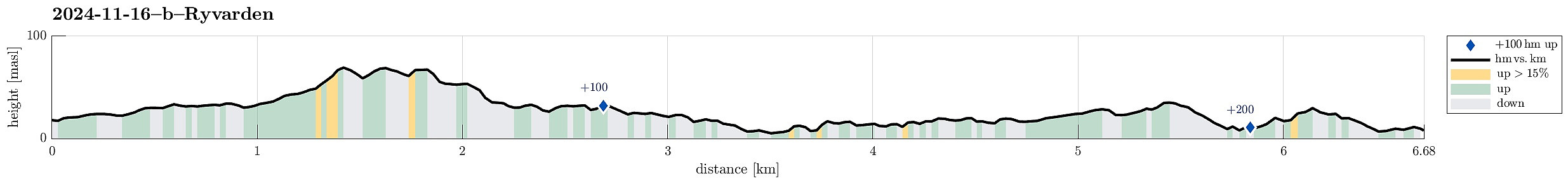 We left one car at the parking lot for Ryvarden in Mølstrevåg, while driving with the other one to Lyngholm a bit further north. There, we found a place, where we could leave the car for 20 NOK. There, we started our hike, following the well-marked North Sea Trail (Nordsjøløypa). Right in the beginning, the weather was a bit rough (strong wind, a bit of rain) -- a bit later, though, it improved and approaching Landsåt, we even got to imagine the sun for some moments! :-) The rather wild weather, however, made walking this trail an interesting experience. Especially the hail showers, which hit us with quite some force due to the strong wind, made sure that we experienced a special kind of presence. :-) Even though the first roughly three kilometers not really are right at the sea, >>>
Morning round on Ryvardsneset
- Datum:
- 16.11.2024
- Tourcharakter:
- Bergtour
- Tourlänge:
- 1:30h
- Entfernung:
- 3,9km
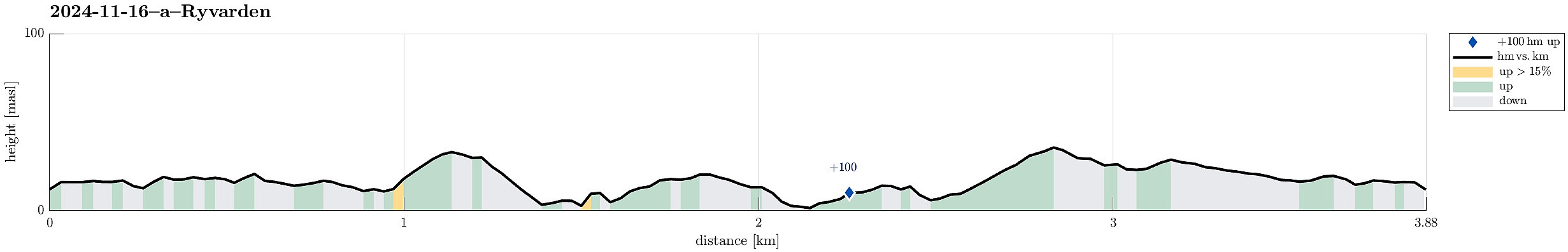 We were staying in one of Flokehyttene on Ryvardsneset and given the rather strong winds the circumstances for easily sleeping into the Saturday were not ideal anyway -- instead, it was much better to get out into the wind and make an attempt to use a rain-free period for a stroll around Ryvardsneset. First, we took the few steps out to the light house at Ryvarden. With all the rather strong winds, it was clearly an impressive experience (and walking down to Huldrahola was by no means a viable option). Next, we visited the commemoration monument for the Sleipner tragedy a bit north of Ryvarden in 1999. Even though breakfast was tempting a real lot, already, there still seemed to be a good opportunity for including a short trail along the southern coast of Ryvardsneset. This trail, when >>>
Valesåta, Trollevassnibba, Monsvarden, Målefjellet
- Datum:
- 15.11.2024
- Tourcharakter:
- Wanderung
- Tourlänge:
- 4:00h
- Entfernung:
- 8,9km
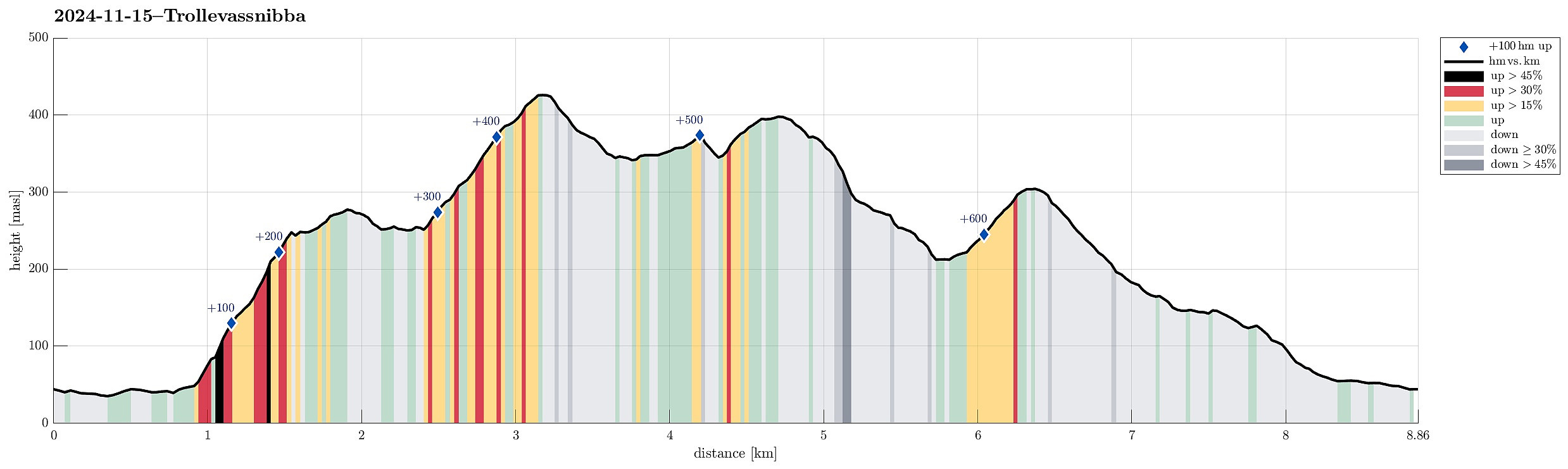 We had left Bergen early on this Friday to still use some daylight time for a hike on Sveio. Right after using the under sea tunnel from Stord, we turned onto Tittelsnesvegen (in a way to head "back" north, but now above the tunnel). Near Valevåg Camping (on the left side of the street) we found a spot to park (on the right side of the street) and started our hike from there. We first continued along Tittelsnesvegen northwards, passing by Valevåg Camping on the left, until we came to the place, where Tittelsnesvegen forks off to the right. Following now this part of Tittelsnesvegen for about two thirds of a kilometer, we got to the trail head on the right of the road. From there, we used a well-marked trail relatively steeply upwards to get up to a ridge in the south of Valesåta. >>>
