Archiv - Nach Datum
Archiv - Nach Aktivität
-
Andere Tour (1)
- Kayaking (1)
-
Andere Wintertour (4)
- Schneeschuhtour (4)
-
Fahrradtour (137)
- Fahrradtour Straße (9)
- Fahrradtour gemischt (51)
-
Fußtour (740)
- Bergtour (363)
- Jogging (18)
- Spaziergang (89)
- Wanderung (270)
-
Skitour (4)
- Tourenskilauf (4)
Archiv - Nach Geografie
Peakbookfreunde


Gesammelte Listen
-
Bergen ≥ 50m pf. og ≥ 100 m.o.h.
(87/89)
 97%
97% -
Most dominating tops of the Bergen peninsula
(68/75)
90%
-
Utvalgte topper og turmål i Bergen
(316/350)
90%
-
Alle topper i Bergen
(357/398)
89%
-
Opptur Bergen
(100/113)
88%
-
De syv fjell rundt Bergen
(6/7)
85%
-
Sund ≥ 50m pf.
(14/18)
77%
-
Os ≥ 50m pf.
(25/34)
73%
-
Søyler (fastmerker) i Bergen
(68/100)
68%
-
Fjell ≥ 50m pf.
(21/32)
65%

Biking Askøy with Dyrdalsfjellet
- Datum:
- 15.05.2026
- Tourcharakter:
- Fahrradtour gemischt
- Tourlänge:
- 4:00h
- Entfernung:
- 38,2km
 After work, we still wished to get out and thus decided to make a bike-trip to Askøy. After following the main bike-route to Askøy, which follows first Kjøkkelvikveien, north of Loddefjord, before then continuing along Sundby Hvorups vei to connect to the large bridge, we then cycled up Stongafjellsvegen to get up to the south of Dyrdalsfjellet. In fact, it was possible to bike almost all the way up and we "only" had a few height meters left to walk, after leaving our bikes behind on the saddle in the south of Dyrdalsfjellet. After first enjoying the views from Dyrdalsfjellet, we then included also Varden at Øvre Kleppe for some more nice views. Once back to the bikes, we decided that we could make a round via Erdalen before heading back. We therefore continued to bike in >>>
Nice round on Herdla
- Datum:
- 16.02.2025
- Tourcharakter:
- Wanderung
- Tourlänge:
- 2:30h
- Entfernung:
- 7,7km
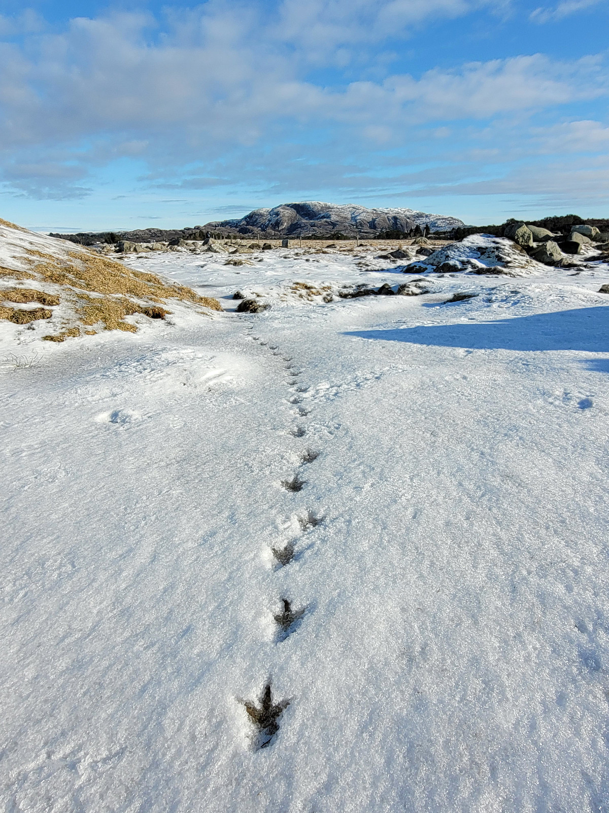 With yet another sunny day on the horizon, we thought that visiting Herdla (after a long time again) would be nice. We thus drove across Askøy and parked near the church of Herdla. We then walked along Herdlevegen to get first to Valen. After following the "inner" shoreline (to Herdlevågen), we followed a historic access road up Småkalvsøyna, exploring some of the still present WWII positions there. From the southeastern "top" of Småkalvsøyna, we then aimed directly at Storakalvsøyna, right in the east of Småkalvsøyna. This brought us to the southeastern end of Paddehola, offering some nice views from there. We also crossed over the south end of this isthmus, enjoying some additional nice views also from there. From there, we then found a reasonable way up >>>
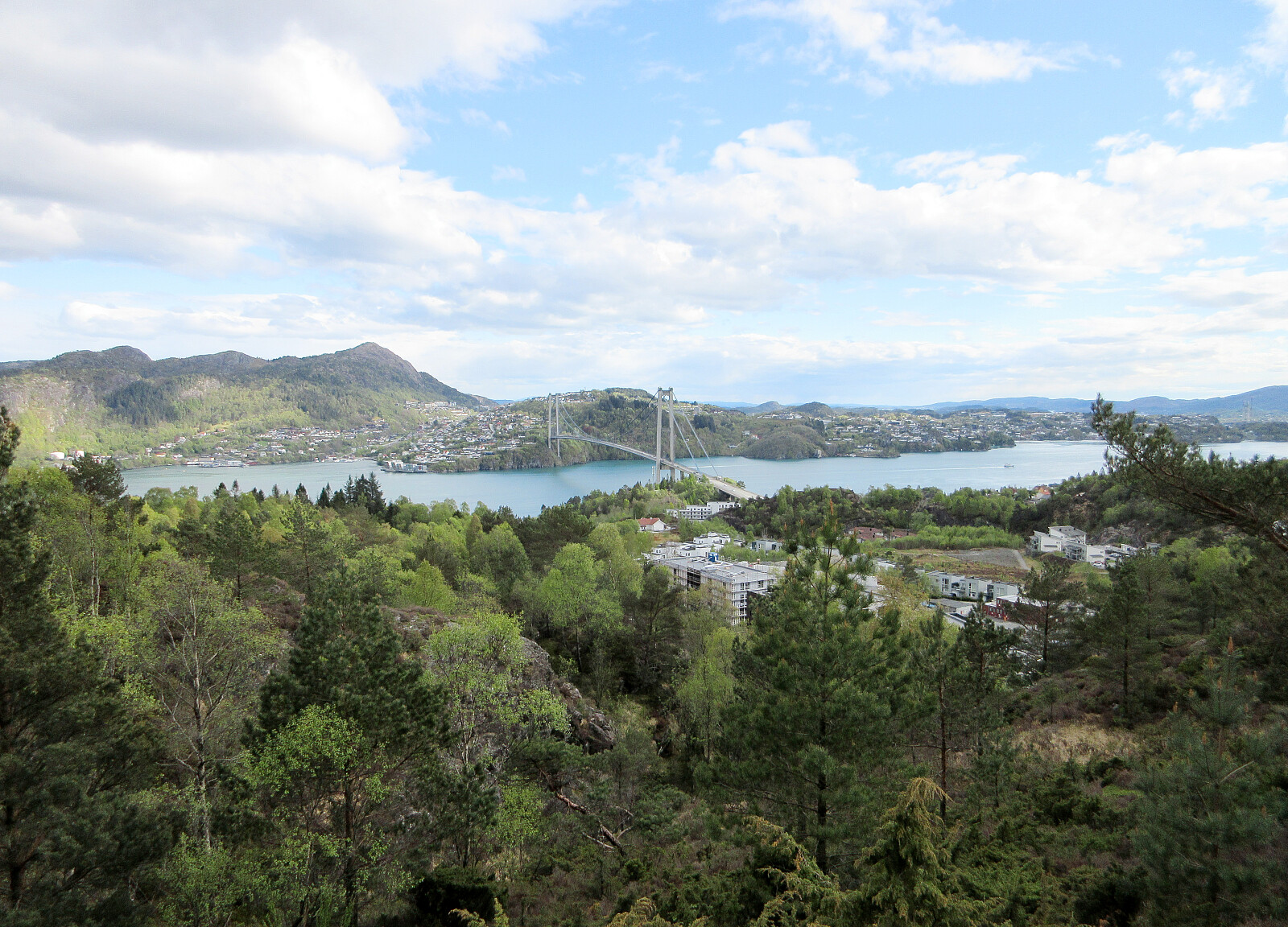
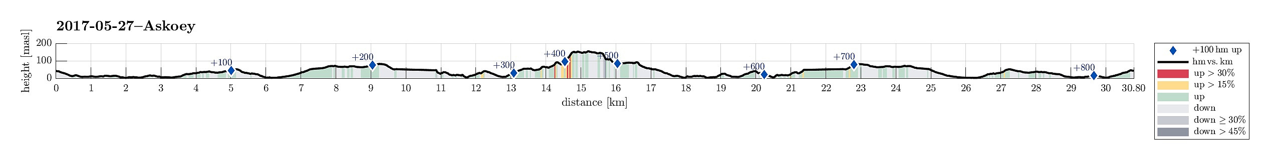
Cycling to Askøy with Folleseåsen
- Datum:
- 27.05.2017
- Tourcharakter:
- Fahrradtour gemischt
- Tourlänge:
- 3:00h
- Entfernung:
- 30,8km
 We started our little cycling trip in the south of Fyllingsdalen and took Bjørgeveien towards Loddefjord. From there, we connected to Kjøkkelvikveien and at Nybø, we connected to Sundby Hvorups vei, which brings cyclists (and pedestrians) to the southern end of the large bridge to Askøy (drivers take a tunnel). We crossed over the Askøy-bridge and followed the sidewalk to the place, where a bigger bus-stop is. There, right behind the bus-stop, a steep path is leading downwards to Skarholmvegen. Turning sharply right, once down there, we took Skarholmvegen towards the west on the southern edge of Askøy. We followed this road until we came to Strusshamn, where we continued northover (and upwards), until we got to Follesevegen. There, we continued again westwards (a little), until >>>
Dronninga on Askøy
- Datum:
- 20.05.2017
- Tourcharakter:
- Bergtour
- Tourlänge:
- 2:00h
- Entfernung:
- 7,6km
 We took the car from Bergen to Askøy and continued northwards on road #562 in the direction of Ravnanger. At Haugland, right after crossing over Loneelvi and then passing under a small bridge, we left the main road to Hauglandsmyra, where we parked at once.
In order to get to Dronninga, we walked first along Hauglandsmyra (the one part of it, which first leads northwards, between houses on the left and some meadow on the right). This brought us to Rispeleitet, which eventually leads in eastern direction (then really towards Dronninga). At the very end of Rispeleitet (at Kolbeinsmyra) the paved road becomes a stone road (maybe not for regular cars), which we followed all to the end (repeatedly one also finds signs, leading the way towards Dronninga). Very close to the "top" of >>>
We took the car from Bergen to Askøy and continued northwards on road #562 in the direction of Ravnanger. At Haugland, right after crossing over Loneelvi and then passing under a small bridge, we left the main road to Hauglandsmyra, where we parked at once.
In order to get to Dronninga, we walked first along Hauglandsmyra (the one part of it, which first leads northwards, between houses on the left and some meadow on the right). This brought us to Rispeleitet, which eventually leads in eastern direction (then really towards Dronninga). At the very end of Rispeleitet (at Kolbeinsmyra) the paved road becomes a stone road (maybe not for regular cars), which we followed all to the end (repeatedly one also finds signs, leading the way towards Dronninga). Very close to the "top" of >>>
Askøy-cycling with Åsebøåsen
- Datum:
- 14.05.2017
- Tourcharakter:
- Fahrradtour gemischt
- Tourlänge:
- 3:30h
- Entfernung:
- 53,4km
 I took my bicycle from Varden in the southwest of Fyllingsdalen and followed first Bjørgeveien towards Loddefjord. Shortly before getting there, I first thought to take the pedestrians' bridge over Lyderhornveien in order to get to Bjørndalsbakken. I was mislead, there, however, since the according signs were crossed out. Thus, I thought that I had no other choice than to use Lyderhornveien in order to get to Loddefjord (not the nicest street to cycle). From Loddefjord, I continued along Lyderhornveien in northern direction (here it's fully OK to cycle), until I got to Kjøkkelvikveien, which I followed further northwards. Via Krabbedalsflaten, I got further to Sundby Hvorups vei, which I cycled upwards and over a minor top in order to connect to the big Askøy-bridge (only possible >>>
Storevarden and Kolbeinsvarden
- Datum:
- 13.12.2015
- Tourcharakter:
- Bergtour
- Tourlänge:
- 1:15h
- Entfernung:
- 4,9km
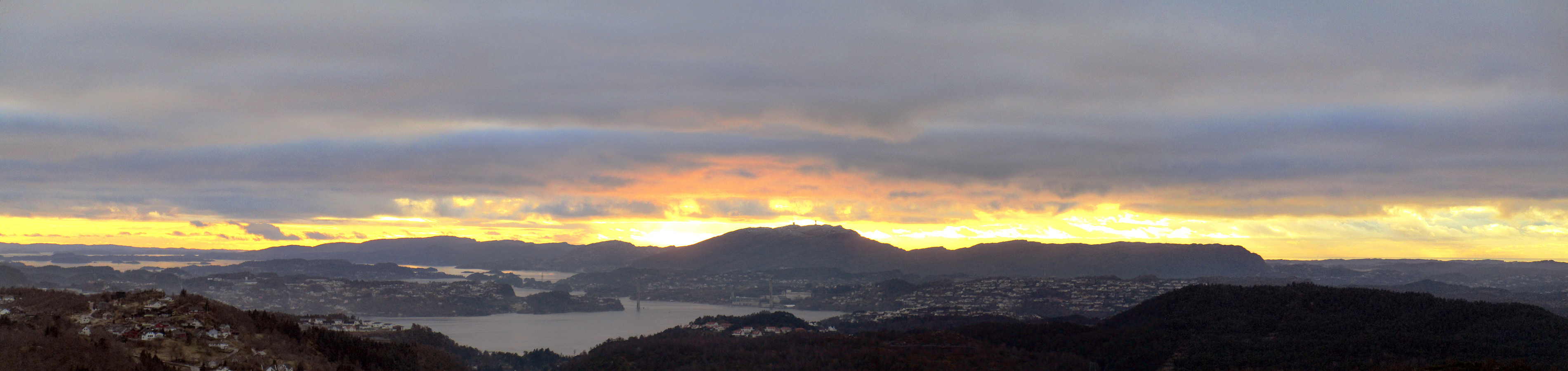 We parked near Erdal church on the east of Askøy, a few kilometers north of Kleppestø. From there, we first followed a road, Svartedalsvegen. Right after two U-turns, a small road departs to the right, leading to a few houses (two?) that are "kind of hidden" in a small valley. We passed the houses (in the valley), searching for a good spot to ascend to Storevardsbrekka, i.e., another road much higher up that is servicing houses that are built high up the hillside. We found a way to get up there, but it was comparably wild and not recommended. Back on the street (now Storevardsbrekka), we followed it until the end from where a path leads on the remaining few meters up to Storevarden. From there, we followed a path northwards, passing by Langafjellet and connecting to the main >>>
Storevarden
- Datum:
- 07.11.2015
- Tourcharakter:
- Bergtour
- Tourlänge:
- 1:00h
- Entfernung:
- 3,6km
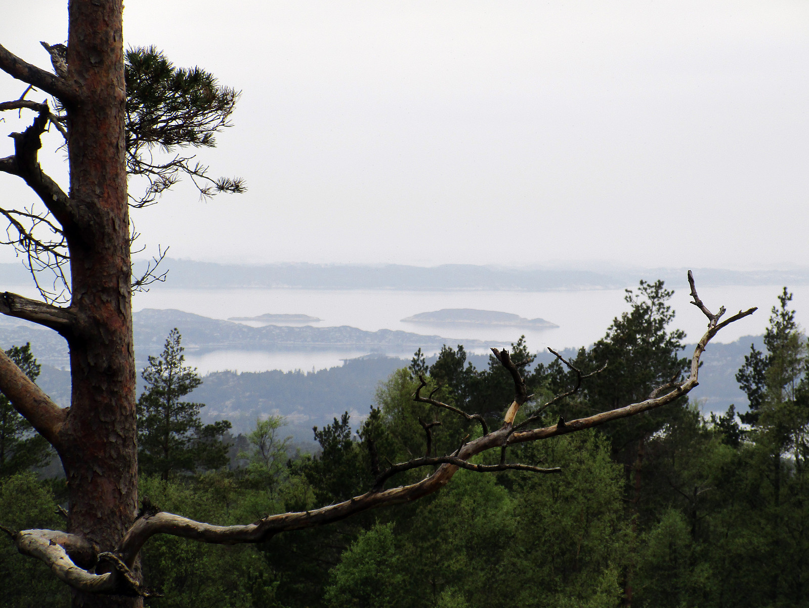
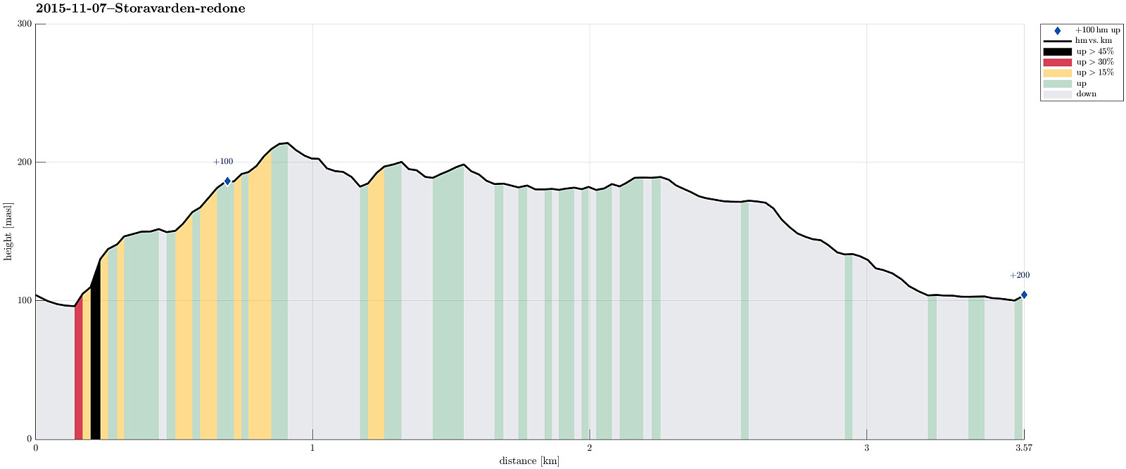 We parked along Bergheimvegen (near Skogedalen) and walked a few meters along the road (towards East), before we found the path up towards Storevarden (on the left). Within a few minutes, we reached a ridge that easily leads towards Storevarden. From there, one has a nice view over Byfjorden and Bergen. We then continued towards Langafjellet (one should take care to not start too much to the East, where a nice ridge invites to be followed---instead, one should look out for a small path that leads downwards, before connecting to Langafjellet). On the other side of Langafjellet, we connected back to a place, which we have visited recently---right next to a very nice small lake. From there, we basically turned back (on the "main path", however, that is a little to the West of the >>>
Kolbeinsvarden
- Datum:
- 27.09.2015
- Tourcharakter:
- Bergtour
- Tourlänge:
- 2:30h
- Entfernung:
- 7,5km
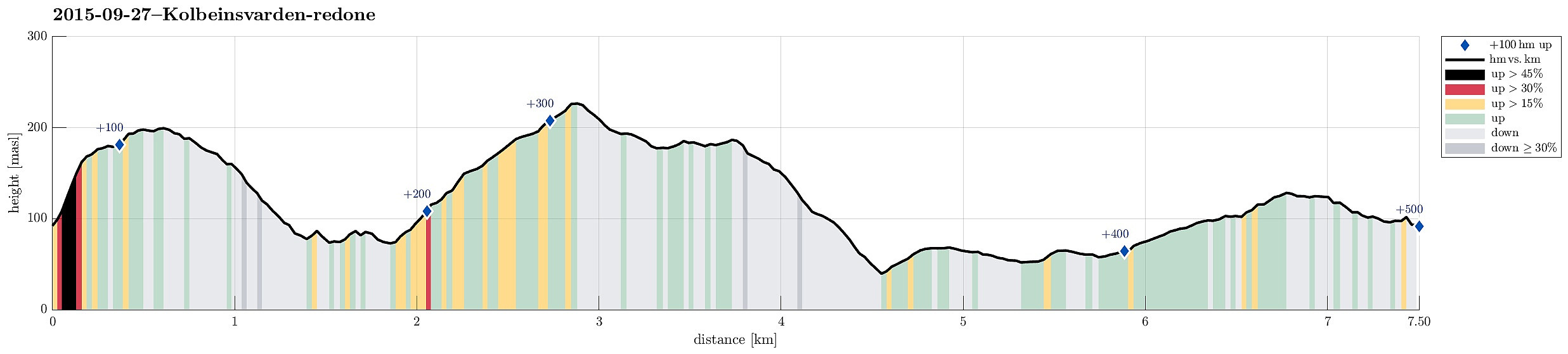 Aiming for a quick sunday afternoon hike, we drove to Askøy and found our way to Bergheim. Only a few meters into Bergheimsvegen, we found a place to stop and a path that would lead to Kolbeinsvarden. Instead of directly going there, however, we first ascended to Birkafjellet, which is a nice cliff right over Kleppe with great views! From there, we followed the path northwards (and downwards) until we came to a fence that protects Kleppevatnet. The path continues right next to the fence and we followed it further, searching for the right spot to ascend to Kolbeinsvarden. After a short detour -- basically, we followed the path along the fence a little too far, we found the (pretty well visible) path and ascended through a nice little valley up to the heights right underneath Kolbeinsvarden. >>>
