Archiv - Nach Datum
Archiv - Nach Aktivität
-
Andere Tour (1)
- Kayaking (1)
-
Andere Wintertour (4)
- Schneeschuhtour (4)
-
Fahrradtour (137)
- Fahrradtour Straße (9)
- Fahrradtour gemischt (51)
-
Fußtour (740)
- Bergtour (363)
- Jogging (18)
- Spaziergang (89)
- Wanderung (270)
-
Skitour (4)
- Tourenskilauf (4)
Archiv - Nach Geografie
Peakbookfreunde


Gesammelte Listen
-
Bergen ≥ 50m pf. og ≥ 100 m.o.h.
(87/89)
 97%
97% -
Most dominating tops of the Bergen peninsula
(68/75)
90%
-
Utvalgte topper og turmål i Bergen
(316/350)
90%
-
Alle topper i Bergen
(357/398)
89%
-
Opptur Bergen
(100/113)
88%
-
De syv fjell rundt Bergen
(6/7)
85%
-
Sund ≥ 50m pf.
(14/18)
77%
-
Os ≥ 50m pf.
(25/34)
73%
-
Søyler (fastmerker) i Bergen
(68/100)
68%
-
Fjell ≥ 50m pf.
(21/32)
65%

Bike-hiking hills near Drotningsvik
- Datum:
- 06.10.2024
- Tourcharakter:
- Fahrradtour gemischt
- Tourlänge:
- 4:00h
- Entfernung:
- 32,9km
 Given the medium-nice weather -- certainly good enough, though! -- I decided to make another bike-hiking trip: this time into the direction of Drotningsvik, where I knew of a couple of hills that I had not visited so far. I started by cycling into the direction of Olsvik, passing by Loddefjord on my way. In the northwest of Harafjellet, I then left my bike behind for the first time, making my way up to Storhaugen. Given the houses that have been built right up to the "top" of Storhaugen, one does not really get any nature feeling up there. The views, however, are quite fine. Next, I aimed at Godvikaskjenet, approaching it from the northeast. Godvikveien leads up there quite steeply and I left my bike behind "half way up" that road. Once closer to the "top", >>>
Short round at Varden
- Datum:
- 05.10.2024
- Tourcharakter:
- Spaziergang
- Tourlänge:
- 0:45h
- Entfernung:
- 2,4km
 Despite the rain, some fresh air was needed, and thus I made a short round at Varden. Good to get out for a short while! :-)
See also the related FB-page Hiking around Bergen, Norway .
Despite the rain, some fresh air was needed, and thus I made a short round at Varden. Good to get out for a short while! :-)
See also the related FB-page Hiking around Bergen, Norway .
Knappen
- Datum:
- 29.09.2024
- Tourcharakter:
- Spaziergang
- Tourlänge:
- 0:45h
- Entfernung:
- 4,7km
 Instead of doing something larger and longer, we "ended up" making a short excursion to Knappen, only. Short, but nice! :-)
See also the related FB-page Hiking around Bergen, Norway .
Petter Bjørstad has a useful page about Knappen .
Web page UT.no from the Norwegian Trekking Association recommends another hike to Knappen .
Instead of doing something larger and longer, we "ended up" making a short excursion to Knappen, only. Short, but nice! :-)
See also the related FB-page Hiking around Bergen, Norway .
Petter Bjørstad has a useful page about Knappen .
Web page UT.no from the Norwegian Trekking Association recommends another hike to Knappen .
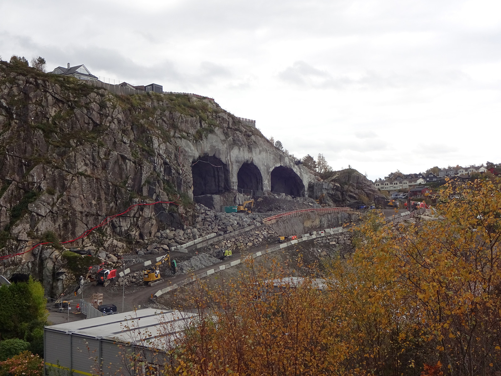
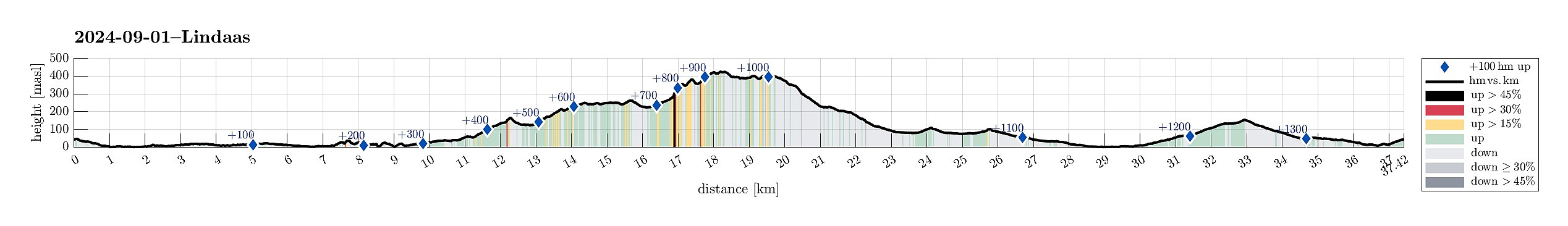
Bike-hiking Landåsfjellet and more
- Datum:
- 01.09.2024
- Tourcharakter:
- Fahrradtour gemischt
- Tourlänge:
- 4:00h
- Entfernung:
- 37,5km
 Somehow, I thought that this Sunday was the day for visiting Nattlandsfjellet and checking out the view-point right above the tunnel of Nye Sædalsveien. I got onto my eBike and biked around the south of Bønes, following the north shore of Nordåsvatnet. This brought me to Gamlehaugen, where I decided to interrupt my bike-trip for a short exploration of the area around the King's house. My first goal there was to get up to the small hill in the southeast of the mansion. I first thought that there would be a way to get there "directly", just to find that this little hill has some rather steep cliff on its west-side -- not high, but high enough to be an obstacle. Walking around, however, brought me to a path that -- while apparently not much used -- lead me easily and conveniently >>>
Bike-hiking Milde and Hordnesskogen
- Datum:
- 31.08.2024
- Tourcharakter:
- Fahrradtour gemischt
- Tourlänge:
- 5:00h
- Entfernung:
- 48,6km
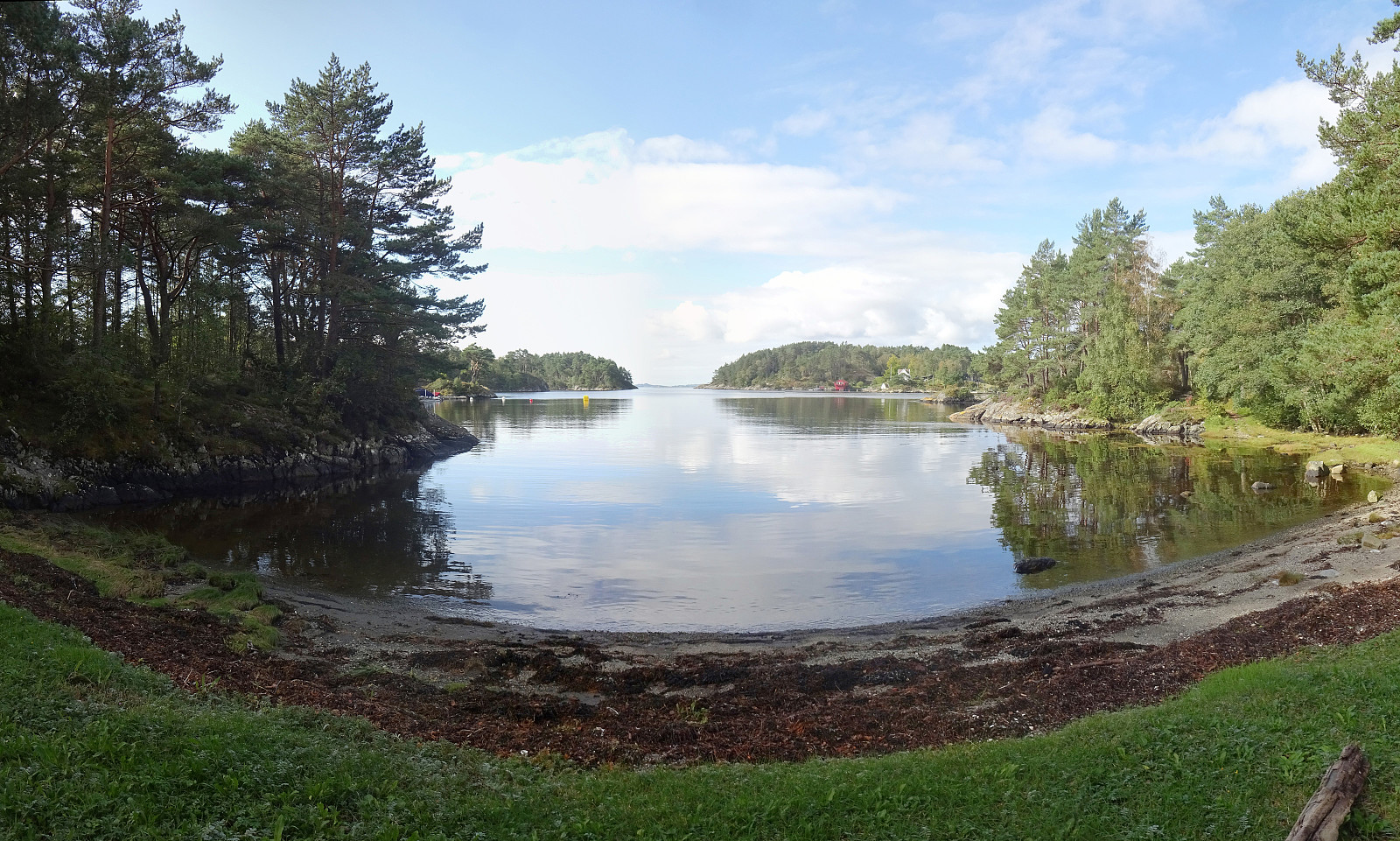 With a nice Saturday at my hand (and foot), I decided to explore the southwest of Milde. I thus mounted my eBike and cycled southwards, passing by Straume and biking along Ytrebygdsvegen, then continuing into the direction of Hjellestad/Milde. While biking by the Arboretet at Milde, one of the spokes on one wheel snapped -- not good. I still continued further southwards, aiming at Skipanesvegen in the south of Mildevatnet. Near Steingardsvikane, I left my bike behind and continued to do a short hike. I first walked along a trail that leads over to Okshammarsvika from Steingardsvikane. At the first nice bay, north of Steingardsvikane, I then found a trail that suggested to bring me up to Slettåsen. While this trail was easy to follow, first, it became less clear near the "top" >>>
Wet Arboretet
- Datum:
- 24.08.2024
- Tourcharakter:
- Spaziergang
- Tourlänge:
- 3:00h
- Entfernung:
- 3,7km
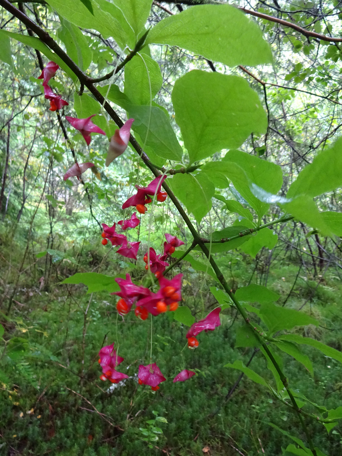 Despite the rather wet weather forecast, we still embarked on a visit to Arboretet in Milde. It was nice (and [very] wet). :-)
Selected photos are available as Google photo album .
See also the related FB-page Hiking around Bergen, Norway .
Despite the rather wet weather forecast, we still embarked on a visit to Arboretet in Milde. It was nice (and [very] wet). :-)
Selected photos are available as Google photo album .
See also the related FB-page Hiking around Bergen, Norway .
Skåldalsnipa direttissima via Moldalia
- Datum:
- 18.08.2024
- Tourcharakter:
- Wanderung
- Tourlänge:
- 2:30h
- Entfernung:
- 5,1km
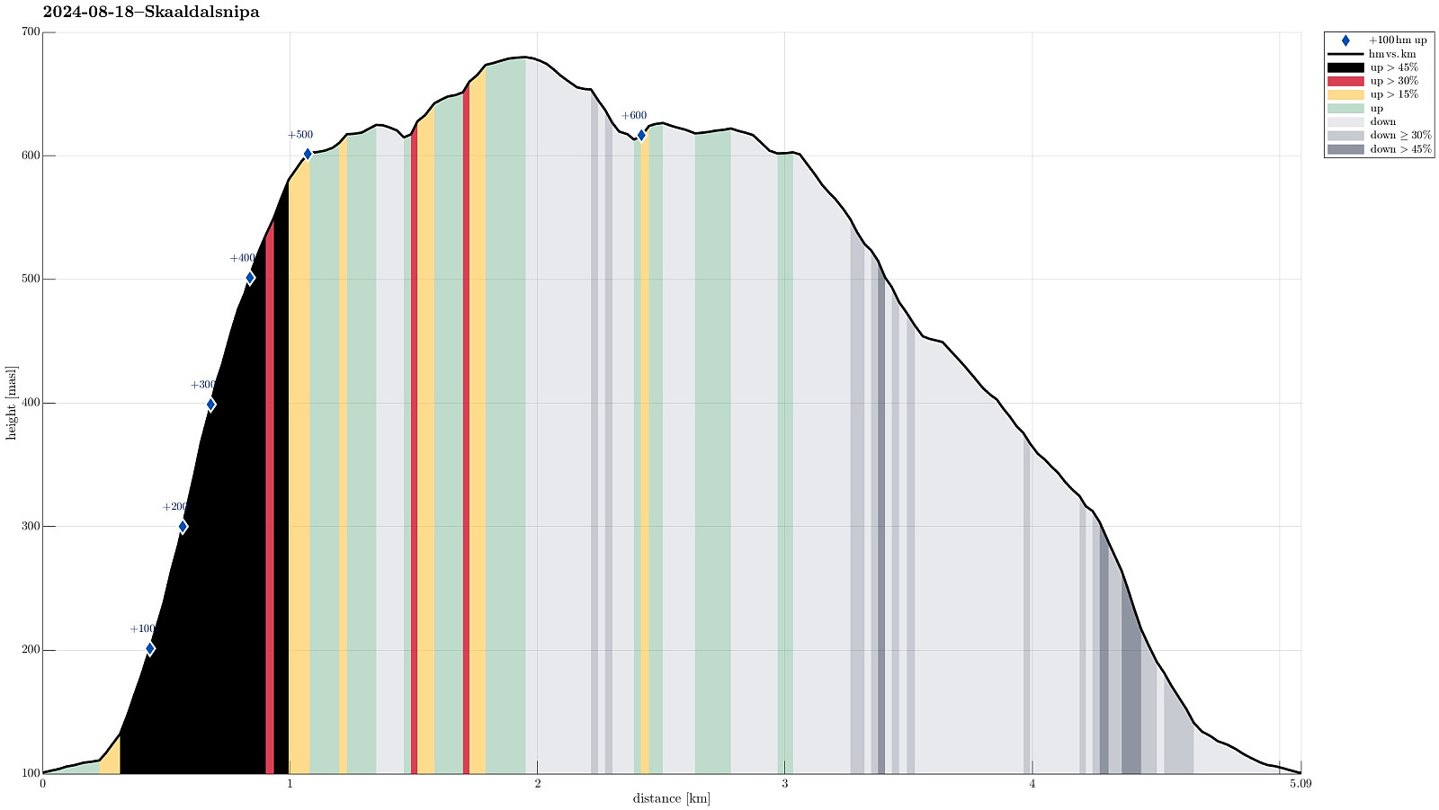 The idea was to ascend to Skåldalsnipa "direttissima" via Moldalia. Why not? Not a good idea on a wet day -- probably true. Still, this is what happened anyway. Consider with care, if you -- for whatsoever reason -- wished to do the same. From the road with name Moldalia it was first "gently upwards" in eastern direction, walking along a proper forest road / trail. As soon as after passing by the last houses, however, it was into the forest and up the slope. From this point, and up to Skåldalsnipa, it was then mostly a climbing effort using all four extremities. Also, there was quite some vegetation to get around. Quite a bit of this vegetation, however, was also helpful to provide some additional grip. Once above about 500 masl (and there above the tree line), >>>
Lyderhorn as a nice extra
- Datum:
- 28.07.2024
- Tourcharakter:
- Wanderung
- Tourlänge:
- 1:30h
- Entfernung:
- 3,2km
 After first exploring Lysøya and then taking a look at Lyseklosteret , we decided that we were still up for a short visit to Lyderhorn. We parked north of Kjøkkelvikskole (along Gamle Kjøkkelvikveien), and then followed the "standard trail" up to Små-Lyderhorn (via Olderdalen). The last 130 height meters, approximately, are then "straight up" to Lyderhorn in a northwards direction, scaling the rather steep southern side of the mountain. After enjoying some nice views from the top, we then took an alternative route down (first further northwards, down to about 330 masl, before then turning left). While first taking the right turn left, after descending northwards along the main trail from the top of Lyderhorn, we then still got confused (regarding the right spot for starting the off-main-trail descent) and included >>>
Evening walk to Knappen
- Datum:
- 26.07.2024
- Tourcharakter:
- Bergtour
- Tourlänge:
- 1:30h
- Entfernung:
- 4,5km
 With still a couple of daylight hours to go (easy in July around here!), we decided to simply make a short round to Knappen. Evening light is actually quite nice -- also on Knappen! :-)
Selected photos are available as Google photo album .
See also the related FB-page Hiking around Bergen, Norway .
Petter Bjørstad has a useful page about Knappen .
Web page UT.no from the Norwegian Trekking Association recommends another hike to Knappen .
With still a couple of daylight hours to go (easy in July around here!), we decided to simply make a short round to Knappen. Evening light is actually quite nice -- also on Knappen! :-)
Selected photos are available as Google photo album .
See also the related FB-page Hiking around Bergen, Norway .
Petter Bjørstad has a useful page about Knappen .
Web page UT.no from the Norwegian Trekking Association recommends another hike to Knappen .
Exploring Ytrebygda a little more
- Datum:
- 24.07.2024
- Tourcharakter:
- Fahrradtour gemischt
- Tourlänge:
- 2:30h
- Entfernung:
- 27,8km
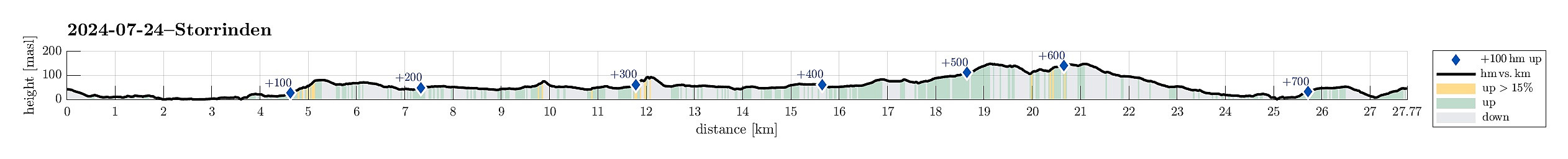 To get some fresh air in the nice weather, I embarked on a short bike trip with a few small walking bits. I first explored Storåsen on Dolvikhaugene, just to find the "actual top" to be a bit too much within the houses around it. I then visited Skranevatnet in the southwest of Feråsen, which was a nice surprise. Next, I explored Storasåta in the north of Ytrebygsvegen. When approached from the north/northeast, one can actually find a proper trail that leads up to this small hill. Thereafter, I paid Lilandshaugen a short visit, which offers quite some nice views across the airport of Bergen. I improvised my way up, just to then find out that actually there's a convenient road (Lilandsvegen) that leads up to the vista-point. After biking around Lilandshaugen, I then checked >>>
