Archiv - Nach Datum
Archiv - Nach Aktivität
-
Andere Tour (1)
- Kayaking (1)
-
Andere Wintertour (4)
- Schneeschuhtour (4)
-
Fahrradtour (137)
- Fahrradtour Straße (9)
- Fahrradtour gemischt (51)
-
Fußtour (740)
- Bergtour (363)
- Jogging (18)
- Spaziergang (89)
- Wanderung (270)
-
Skitour (4)
- Tourenskilauf (4)
Archiv - Nach Geografie
Peakbookfreunde


Gesammelte Listen
-
Bergen ≥ 50m pf. og ≥ 100 m.o.h.
(87/89)
 97%
97% -
Most dominating tops of the Bergen peninsula
(68/75)
90%
-
Utvalgte topper og turmål i Bergen
(316/350)
90%
-
Alle topper i Bergen
(357/398)
89%
-
Opptur Bergen
(100/113)
88%
-
De syv fjell rundt Bergen
(6/7)
85%
-
Sund ≥ 50m pf.
(14/18)
77%
-
Os ≥ 50m pf.
(25/34)
73%
-
Søyler (fastmerker) i Bergen
(68/100)
68%
-
Fjell ≥ 50m pf.
(21/32)
65%

Walk along Sælenvatnet
- Datum:
- 14.02.2021
- Tourcharakter:
- Bergtour
- Tourlänge:
- 1:00h
- Entfernung:
- 2,3km
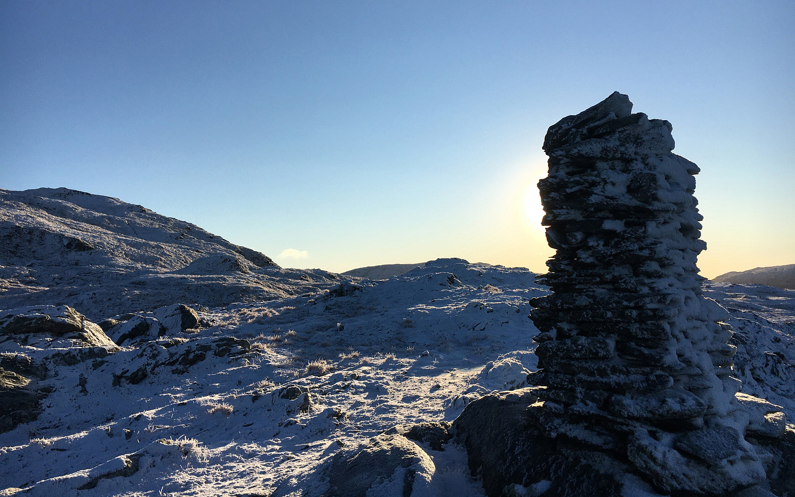
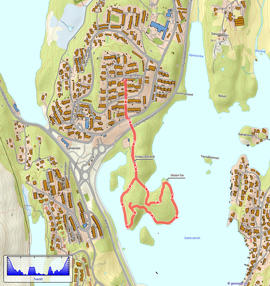 With just a little time at our disposal, we decided to quickly get a little fresh air and make a short walk along the shoreline of (frozen) Sælenvatnet. After walking down from Varden, we crossed over Fyllingsdalsveien, using a small bridge near the big junction with Bjørgeveien. Once on the other side, we walked onto this particular peninsula that extends into Sælenvatnet on its western side. Following some small, but "beaten" paths, we rounded most of this peninsula, before heading back and up to Varden, again. Nice with all that snow! :-)
See also the related FB-page Hiking around Bergen, Norway .
With just a little time at our disposal, we decided to quickly get a little fresh air and make a short walk along the shoreline of (frozen) Sælenvatnet. After walking down from Varden, we crossed over Fyllingsdalsveien, using a small bridge near the big junction with Bjørgeveien. Once on the other side, we walked onto this particular peninsula that extends into Sælenvatnet on its western side. Following some small, but "beaten" paths, we rounded most of this peninsula, before heading back and up to Varden, again. Nice with all that snow! :-)
See also the related FB-page Hiking around Bergen, Norway .
Holefjellet via Storhovden, Eikelifjellet, Gravdalsfjellet
- Datum:
- 13.02.2021
- Tourcharakter:
- Bergtour
- Tourlänge:
- 3:00h
- Entfernung:
- 9,3km
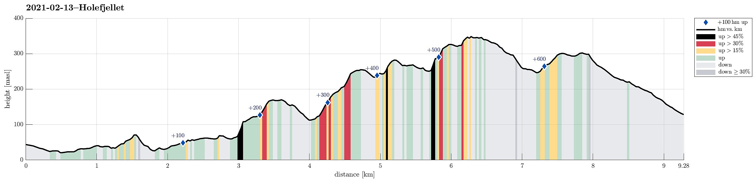 Expecting the unusually stable winter weather to end soon, we decided to get out and enjoy both sun and snow directly where we live, doing "nothing else" than a hike in Kanadaskogen. We started walking northwards from Varden, passing by Sælen church and crossing over the fotball fields in front of the FraMo sports hall, we continued into the direction of Hesjaholten, walking along the houses at Veslefrikkveien in their south. Surrounding Hesjaholten in its west (and below it, there), we entered the valley through which the waters from Krokatjørna come down as a little stream. Walking up this valley, we came to the somewhat more flat (and usually very wet) area in the west of Stora Krokatjørna. Enjoying some lovely sun and nice snow there, we walked across the (usually) boggy >>>
After work stroll north of Varden
- Datum:
- 21.01.2021
- Tourcharakter:
- Bergtour
- Tourlänge:
- 1:30h
- Entfernung:
- 4,2km
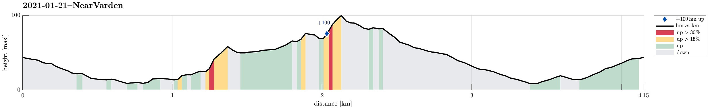 We just wished to refresh ourselves a little after work and thus simply "strolled around" in the neighborhood. The only (very moderately) intersting bit of this short walk was that we tried a new "connection" between Fyllingsdalsveien and Krokatjønnveien, where one can find a good number of trees between the houses, almost a little forest! :-)
See also the related FB-page Hiking around Bergen, Norway .
We just wished to refresh ourselves a little after work and thus simply "strolled around" in the neighborhood. The only (very moderately) intersting bit of this short walk was that we tried a new "connection" between Fyllingsdalsveien and Krokatjønnveien, where one can find a good number of trees between the houses, almost a little forest! :-)
See also the related FB-page Hiking around Bergen, Norway .
Round around Storavatnet
- Datum:
- 09.01.2021
- Tourcharakter:
- Bergtour
- Tourlänge:
- 1:30h
- Entfernung:
- 3,1km
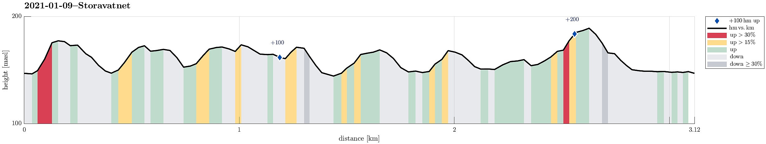 Since there wasn't much daylight left and since the weather was not exactly lovely (it was OK though!), we decided for a short round in the neighborhood. We thus first drove up to Krohnegården in the north of Fyllingsdalen and parked near Svartatjørna. The goal was to make one round aroud Storavatnet (in clockwise direction), but to do that off the main trail. This way, we included a number of small hills, including Søråsen and Nordåsen. From some of them, you actually have some nice views, mostly down into Fyllingsdalen, but also to Løvstakken in the east and Olsokfjellet and Damsgårdsfjellet in the west. While off the main trail, most of this round was still on "minor trails" (and without any difficulties). Only the traverse of the hill in the very northwest of Storavatnet >>>
Herlandsfjellet, Skåldalsfjellet, and Skåldalsnipa
- Datum:
- 03.01.2021
- Tourcharakter:
- Wanderung
- Tourlänge:
- 4:30h
- Entfernung:
- 9,0km
 This Sunday was predicted to come with blue skies and nice winter weather, and so it was! The day before we had arranged for a joint hike up Skåldalsfjellet to catch a good amount of winter sun, while also having some good time in not too deep snow. In order to cross over Skåldalsfjellet (from northeast to southwest), we started at the north-side of Osavatnet, almost at the very end of Gullfjellsvegen, where many of those, who venture into th Gullfjellet-mountains, park and start. Instead of walking towards Gullfjellet, however, we turned towards Ormarinden, a nice ridge that comes down from Herlandsfjellet in the north of Osavatnet. This ridge has a very nice trail on it, making the ascent to Herlandsfjellet straight-forward and non-difficult. At the very top of Herlandsfjellet, we >>>
Nice round through Kanadaskogen
- Datum:
- 02.01.2021
- Tourcharakter:
- Bergtour
- Tourlänge:
- 2:00h
- Entfernung:
- 5,9km
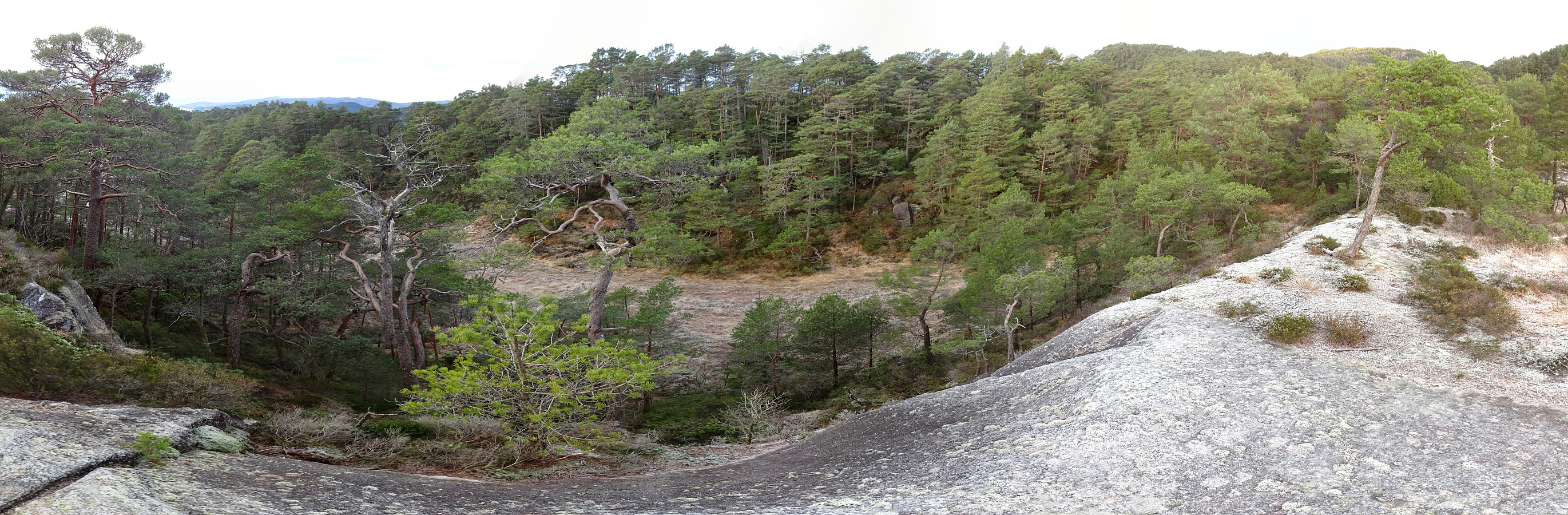 Even though the day was overcast, we still wished to refresh ourselves and thus decided to make a short round through Kanadaskogen. We first walked from Varden to Hesjaholten, following the dead-end road that extends furthest northwards. Almost at the very last house, there's a trail head leading upwards into a small valley in the southeast of Litla Krokatjørna. About half way up into this valley, we turned left and ascended the small hill in the southeast of Litla Krokatjørna. After crossing over it, we descended back into "the small valley", but just to cross it in order to also ascend to the hill on the other (eastern) side. Once over this one, we then continued along its northern ridge, running somewhat between Litla Krokatjørna (in the west) and (Stora) Krokatjørna (in >>>
Knappen (off trail)
- Datum:
- 01.01.2021
- Tourcharakter:
- Bergtour
- Tourlänge:
- 1:30h
- Entfernung:
- 4,0km
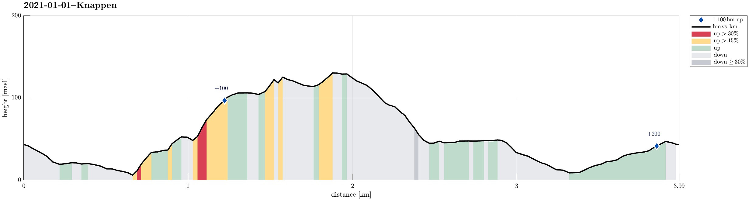 A good way to start a new year, is to do (at least) a small hike in the neighborhood! :-) We started from Varden, walking towards Knappen on the other side of Bjørgeveien. Going Marineveien down, we decided to explore "the other side" right away (without first walking along Bjørgeveien). Even though we did that without any trail, it still was reasonably easy and within a short while we arrived at the top of Sandeidbrotet (this "short-cut" is OK for an exploration, but will not become our new standard route to Knappen, though). From Sandeidbrotet we continued up another short hillside to Vassteigen, where we (for a moment) connected with one of the trails to Knappen. Instead of following this trail, however, we again diverted into "the wild", ascending more >>>
Damsgårdsfjellet and Olsokfjellet
- Datum:
- 27.12.2020
- Tourcharakter:
- Wanderung
- Tourlänge:
- 1:30h
- Entfernung:
- 4,6km
 With a prediction of rain, we weren't motivated to more than just a short round. We parked near Betanien along Vestlundveien in Fyllingsdalen and headed northwards through Nordnæsdalen. The original idea was to find the little trail -- is there a trail? -- which should lead up to the southern "top" of Holefjellet in the west of Damsgårdsfjellet. Soon, however, we had walked too far, getting very close to the saddle between Damsgårdsfjellet and Holefjellet. Instead of walking back (in the rain), we decided to drop Holefjellet for this time and instead start our walk back (via Damsgårdsfjellet and Olsokfjellet). The ascent to Damsgårdsfjellet was straight-forward (no ice, this time!) and then crossing over to Olsokfjellet, walking around Tverrdalen, was similarly easy (the >>>
Kanadaskogen with Hesjaholten
- Datum:
- 25.12.2020
- Tourcharakter:
- Bergtour
- Tourlänge:
- 3:00h
- Entfernung:
- 8,8km
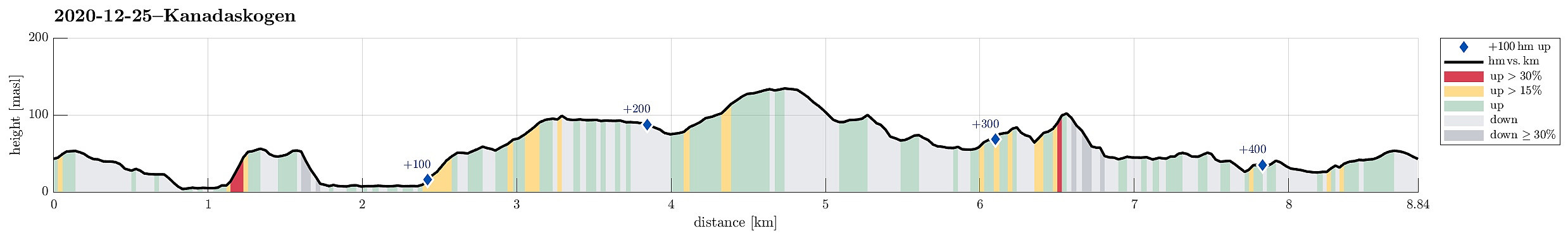 With a somewhat average weather forecast on tap, we decided to "just" do a simple walk/hike in Kanadaskogen. Starting from Varden, we first headed for the eastside of Gjeddevatnet, near the fotball fields and Framohallen. After rounding Gjerdsvika, we ascended a little (in northwards direction) in order to get over to (the eastside of) Bjørndalsvatnet, which we then walked along until its northern most end. Continuing in northwards direction, we then walked up to Svartatjørna. On the other, northern side of it, while walking along Storamyra then, we enjoyed to look up to Tobrik, high up over the east of Storamyra. Walking out this little valley, we ended up at the gravel road that leads up to the dam of Tennebekktjørna. About halv way up this road, we then decided to split >>>
Skåldalsfjellet via Hjelterinden
- Datum:
- 24.12.2020
- Tourcharakter:
- Wanderung
- Tourlänge:
- 3:00h
- Entfernung:
- 7,8km
 The weather forecast promised some blue skies over Bergen! :-) So the goal was to welcome the sun somewhere in the (not too deep) snow. After a bit of discussing different options, we landed on a hike up to Skåldalsfjellet (not at the least because of its chances to catch some sun). Since we've developed a taste for stepping up relatively steep mountain sides, recently, we chose an ascent via Hjelterinden, in the (steep) south of Skåldalsfjellet. Leaving the Bergen valley from Nesttun via Helldal and along Grimevatnet, we drove to Haukeland, first, before there leaving road #587 and then following the narrow road to Unneland. From there, we then drove up Gullfjellsvegen until we came to the saddle that leads into the valley with Skåldalselva. We parked (right at the saddle) and continued >>>
