Archiv - Nach Datum
Archiv - Nach Aktivität
-
Andere Tour (1)
- Kayaking (1)
-
Andere Wintertour (4)
- Schneeschuhtour (4)
-
Fahrradtour (137)
- Fahrradtour Straße (9)
- Fahrradtour gemischt (51)
-
Fußtour (740)
- Bergtour (363)
- Jogging (18)
- Spaziergang (89)
- Wanderung (270)
-
Skitour (4)
- Tourenskilauf (4)
Archiv - Nach Geografie
Peakbookfreunde


Gesammelte Listen
-
Bergen ≥ 50m pf. og ≥ 100 m.o.h.
(87/89)
 97%
97% -
Most dominating tops of the Bergen peninsula
(68/75)
90%
-
Utvalgte topper og turmål i Bergen
(316/350)
90%
-
Alle topper i Bergen
(357/398)
89%
-
Opptur Bergen
(100/113)
88%
-
De syv fjell rundt Bergen
(6/7)
85%
-
Sund ≥ 50m pf.
(14/18)
77%
-
Os ≥ 50m pf.
(25/34)
73%
-
Søyler (fastmerker) i Bergen
(68/100)
68%
-
Fjell ≥ 50m pf.
(21/32)
65%

Gullsteinen from Varden
- Datum:
- 28.05.2023
- Tourcharakter:
- Wanderung
- Tourlänge:
- 1:30h
- Entfernung:
- 7,8km
 We wished to get some fresh air and thus headed for Gullsteinen (from Varden). We first descended from Varden to Sælevatnet, before then surrounding Bondegården in its north. Via Ture Nermans vei we then connected to Rekdalsveien, which we then followed "all the way up" to the point, where one can step down some stairs to the sports area in Fjellsdalen. We then stepped up Hattedalen to get to Bråtet. From there, we then started our ascent to Gullsteinen. While one of us found a way (more a "way"!) up to Knultrane, the other one continued along the gravel road to Nils Langhellesvei (where we met, again, then). From there, it was then up via the southern ridge to Gullsteinen, mostly following the nice trails along this ridge. From the top of Gullsteinen, however, >>>
Ankerhytten from Sandviken
- Datum:
- 18.05.2023
- Tourcharakter:
- Wanderung
- Tourlänge:
- 4:00h
- Entfernung:
- 11,1km
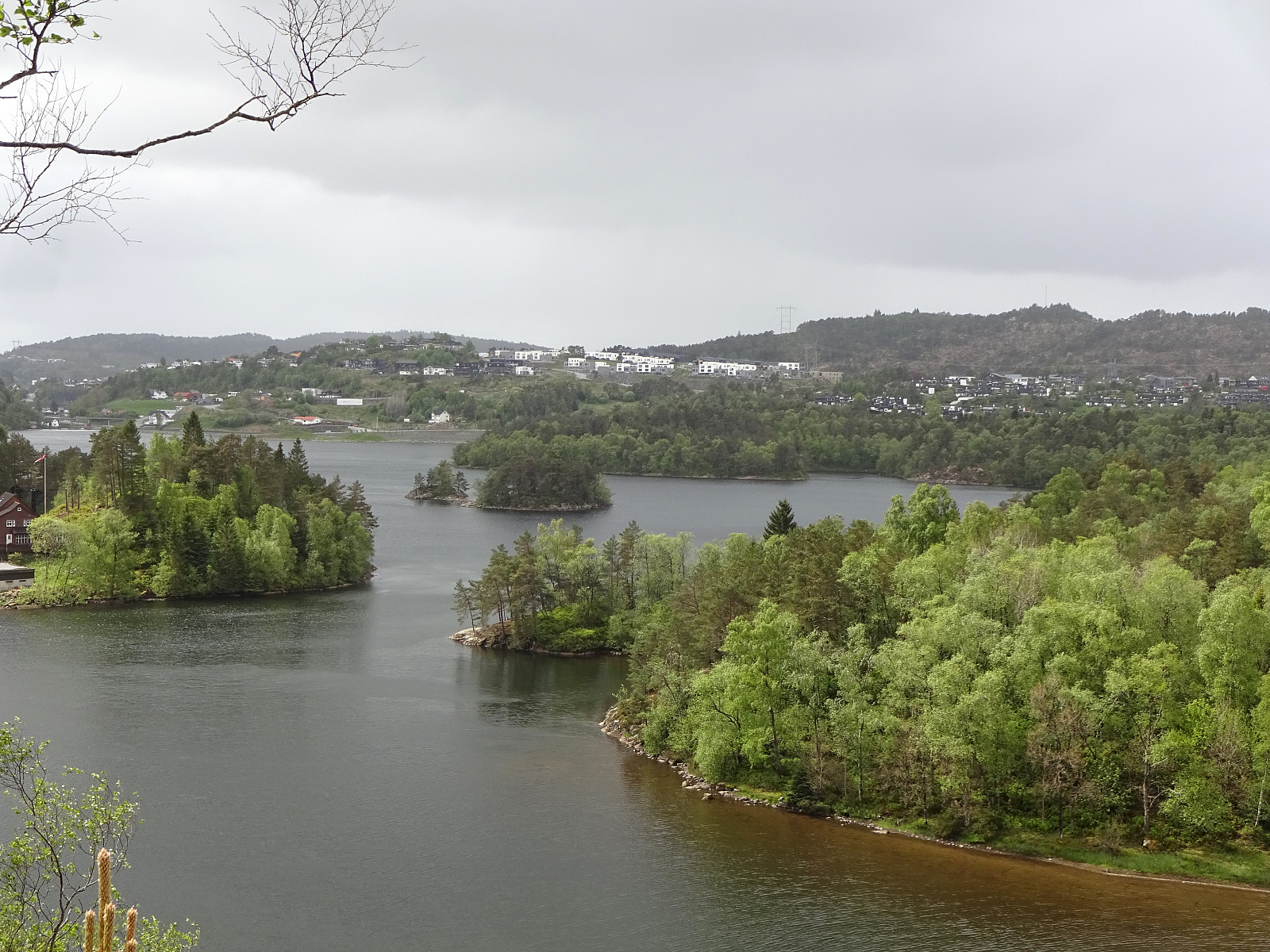
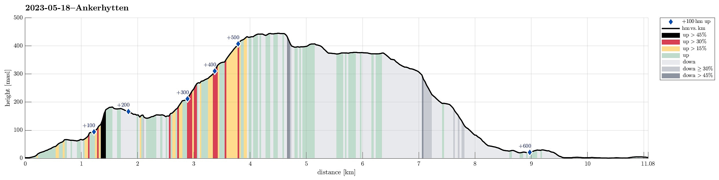 We somehow decided to go a round near Bergen and thus took the bus to Sandviken. After first walking up to Fjellveien, we continued along it to get to Permisjonsstien. This brought us up to Sandviksbatteriet, where we enjoyed the views over Byfjorden. Next on the agenda was to get over to Munkebotn, cross over the stream that runs out of Munkebotsvatnet towards the north, and take the trail up to cabin Ravneberg. This trail is actually quite steep (but nice and straight-forward to hike up), offering some nice views along it. Continuing along the trail, we then passed by (closed) Sandvikshytten, before heading further upwards into the direction of Kvitebjørnen. Instead of hiking all the way to the top of Kvitebjørnen, however, we then followed a lower trail that was supposed to bring >>>
Erdalsvarden from Bratland (or so)
- Datum:
- 13.05.2023
- Tourcharakter:
- Wanderung
- Tourlänge:
- 4:30h
- Entfernung:
- 12,2km
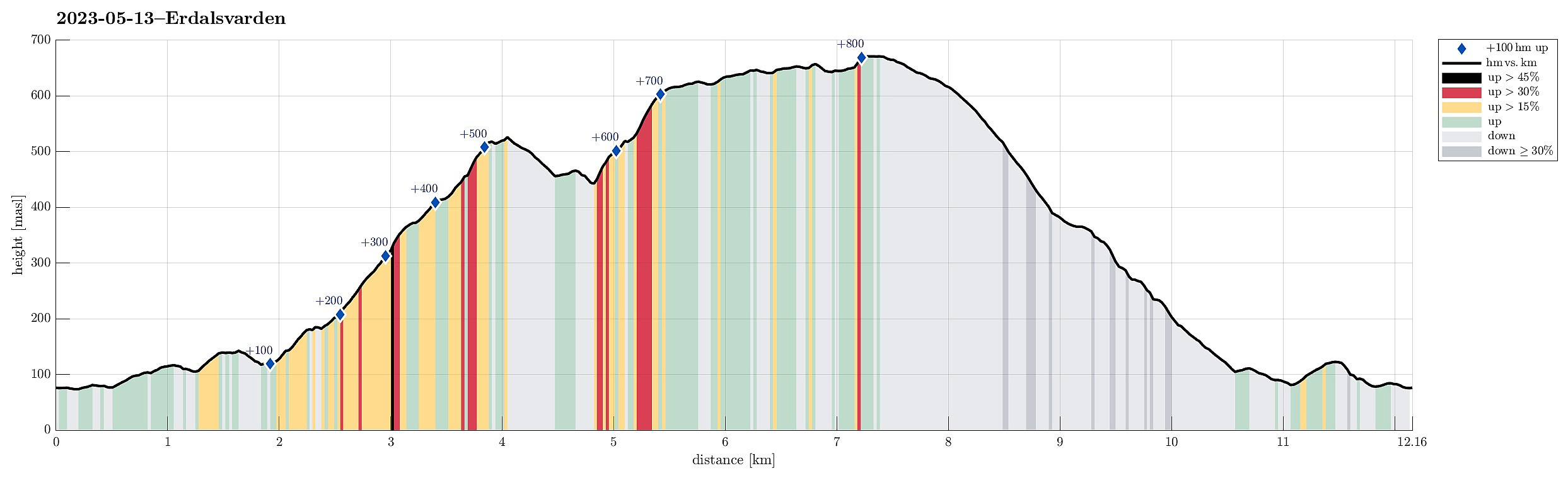 We picked up an older plan to visit Erdalsvarden from Bratland and drove past Grimevatnet to the south of Søylevatnet (along the main road to Arna). We parked where on also can take a trail (in southern direction) to get up to Furedalen. Instead, however, we headed (at large) in northward direction, passing Søylevatnet in its east. We then continued along the ridge that extends from Borgnyhaugen (in the southwest) to Krunhaugen (in the northeast). From there, we followed (for a short stretch) the road up to Øvre Bratland, before turning left at house 146 and then walking along the old postal route between Bergen and Christiania (nowadays Oslo). This brought us to the saddle where one could then continue downwards again (towards Erdalen in southwestern direction). There, we turned right >>>
Høgstefjellet, Tellevikafjellet, and Nordgardsfjellet
- Datum:
- 01.05.2023
- Tourcharakter:
- Wanderung
- Tourlänge:
- 2:30h
- Entfernung:
- 6,8km
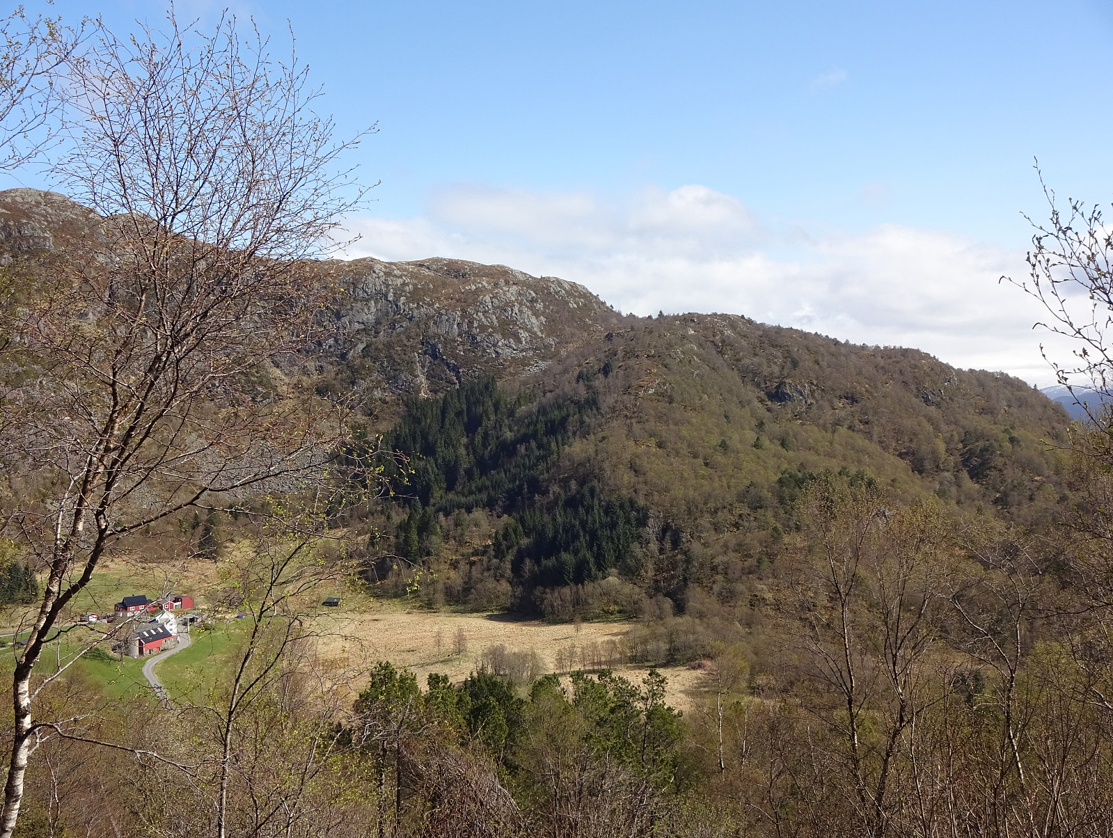 We were up to a medium-long hike and decided to do the round around Baugtveitstemma, including Høgstefjellet, Tellevikafjellet, and Nordgardsfjellet. After driving to Åsane, first, we then continued into the direction of Salhus, turning right at Hitland and entering the narrow road up to Baugtveit. Before actually getting all the way up to Baugtveit, we found a parking place at the parking slot for hikers (Håkonsplass). To get up to Høgstefjellet, we headed into southeastern direction, first. Instead of following the trail in the southwest of Furbudalen, we aimed at the ridge in the northeast of this trail, leading up to Baugtveitgotene. Even though we could not find any trail up this ridge, ascending it was still well doable (there are a few slightly steeper sections -- nothing that >>>
Bjørnaneset in Arboretet
- Datum:
- 29.04.2023
- Tourcharakter:
- Spaziergang
- Tourlänge:
- 2:00h
- Entfernung:
- 4,1km
 With some mixed weather prediction and a few other duties to do on this Saturday, we decided to "just" explore Arboretet in Milde a little further. We parked at the parking lot in the northwest of Arboretet and started our walk along the main gravel road. Only a few meters into it, however, we decided that we rather were up for some exploration and deviated to the south, up Gravåsen. From there, we then connected to Søre Vasshaugen, before then heading in a more northern direction. Near Mørkevatnet, we crossed the gravel road and continued on the western side of this small lake. In the north of it, we then found a convenient way to get over to the other, northeastern side. Already near Vestrepollen there, we continued into the direction of Bjørnaneset, following the shoreline >>>
Slettegga, Austefjellet, and Hausdalshorgi
- Datum:
- 22.04.2023
- Tourcharakter:
- Wanderung
- Tourlänge:
- 4:30h
- Entfernung:
- 11,1km
 It looked like a wonderful spring day and we had a couple of hours. Since we had talked about Slettegga, already, we decided to try a new ascent to Slettegga -- via its southern ridge (up from Bjørnastølen). We drove into the valley of Bontveit (up from Kalandsvatnet) and over the saddle at the high end of the valley and further onto Øvstebøvegen. Near the low point of this road, before crossing over the stream that comes down from the north, we parked and started our hike. Near the bridge over the stream, we left the road to the left and ascended (quite steeply) up Lurabakken. After stepping through a few trees at about 260masl, we continued along a simple trail that leads northwards on the western side of the stream (in parallel to the stream). At about 315masl, we then crossed >>>
Lyderhorn in significant snow
- Datum:
- 11.03.2023
- Tourcharakter:
- Wanderung
- Tourlänge:
- 1:30h
- Entfernung:
- 3,0km
 Given all the snow and also the varied weather forecast, we decided to do something not so long. Being not so far away, and always a nice hike, we decided to hike up and down Lyderhorn. We parked on the western side (along Kjøkkelvikveien) and headed towards the trail up to Små-Lyderhorn (first) through Olderdalen. Very quickly it became clear that this hike would be different from what we usually experience (due to all the snow!). At first, some steps of another person could be still recognized in the snow, but this person had decided about half-way up to turn around, apparently. Continuing further upwards was then a nice challenge, breaking quite a bit into the deep snow at every step. Up at the saddle next to Små-Lyderhorn, we then decided to put on brodders ("light form of >>>
Borga in quite some snow
- Datum:
- 25.02.2023
- Tourcharakter:
- Wanderung
- Tourlänge:
- 5:00h
- Entfernung:
- 10,5km
 There was quite some snow to expect and since we still wished to hike, we aimed at choosing a route that would be possible to hike well, even without snoeshoes. Estimating that Borga should still be fine, we drove to the other side of Vidden and parked along Kvamsvegen near Austrestølane. From there, we first hiked up Sauhola, already stepping through a substantial layer of snow. Once up to Bjørndalen and back to the gravel road that also leads up here (offering a less steep, alternative route up), we turned left and crossed over the stream that continues down Sauhola. Now in a southward direction (towards Nedstaflåna), we started to surround Bjørndalen in its south with the goal to find a suitable route up to Borga in the southwest of Bjørndalen. At first, up to about 400masl, this >>>
Biking Grimseidvegen (with Storrinden and Stendafjellet)
- Datum:
- 05.02.2023
- Tourcharakter:
- Fahrradtour
- Tourlänge:
- 2:30h
- Entfernung:
- 35,6km
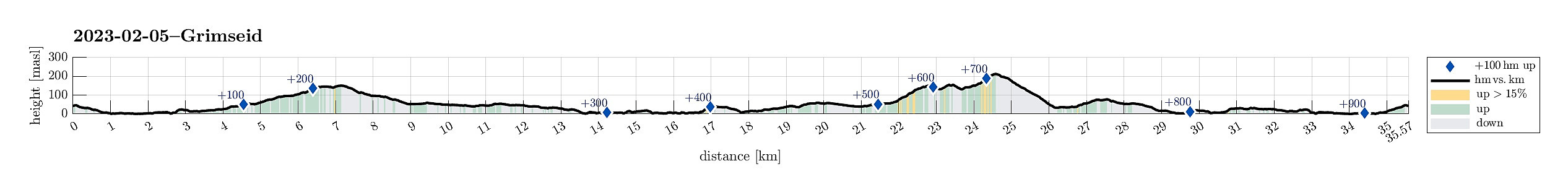 This time, we were in the mood for a bike trip. We headed first south, passing by Sælenvatnet in its southwest, before then crossing over the narrow connection of Nordåsvatnet and Grimstadfjorden. While heading further southwards, we included a detour up to Storrinden (this was quite interesting as substantial sections of the road up and down were covered with ice). Once back on Ytrebygdsvegen, we continued further southwards. We crossed Flypassvegen and continued into the direction of Hjellestad. Before actually getting there, however, we turned left (twice) to get onto Grimseidvegen. This way, we had changed direction and were cycling in about eastern/northeastern direction. Once passed Grimseidvatnet, we turned right to get onto Skeievegen that brought us to the other side of Hordnesskogen >>>
Liafjellet, Strandafjellet, and Ravnefjellet
- Datum:
- 22.01.2023
- Tourcharakter:
- Wanderung
- Tourlänge:
- 2:00h
- Entfernung:
- 4,5km
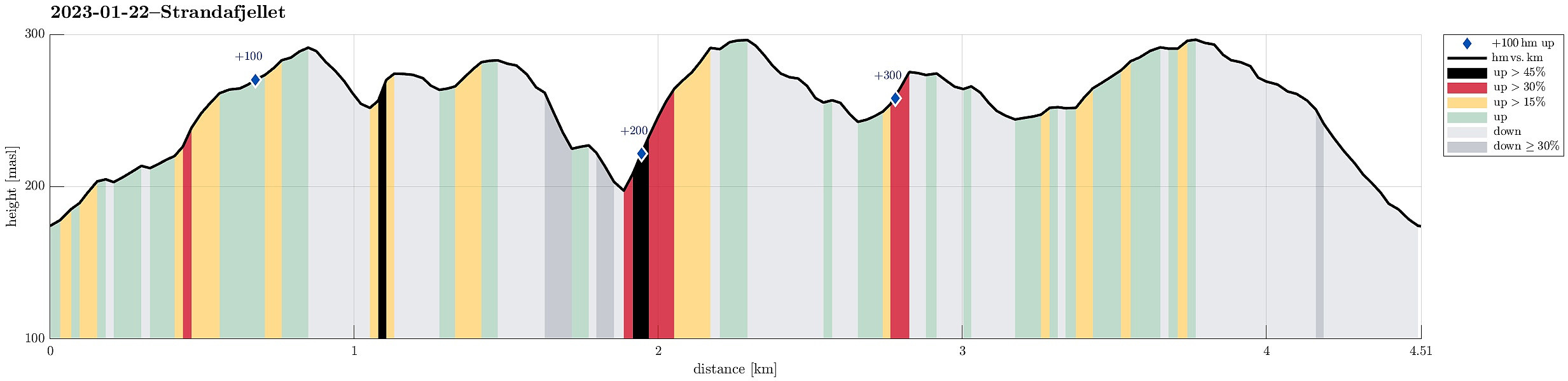 We biked to the northwestern end of Løvstien at Øvre Riplegården and started our exploration from there. We first ascended to the ridge in the west of Nilsadalen, following it then towards the south (and upwards). When eventually close to Ravnefjellet (in the west), we crossed over (towards the east) to get up to the southern top of Liafjellet. From there, we connected to the northern top of Liafjellet. Next, we aimed at Strandafjellet via Juvdalen. The descent from Liafjellet into Juvdalen was a bit steep, but still OK. Once in Juvdalen, we descended just a bit more to get up to the northern ridge of Strandafjellet without any climbing. Ascending to Strandafjellet via its northern ridge was then straight-forward and nice. From Strandafjellet, we then connected back to Liafjellet, >>>
