Archiv - Nach Datum
Archiv - Nach Aktivität
-
Andere Tour (1)
- Kayaking (1)
-
Andere Wintertour (4)
- Schneeschuhtour (4)
-
Fahrradtour (137)
- Fahrradtour Straße (9)
- Fahrradtour gemischt (51)
-
Fußtour (740)
- Bergtour (363)
- Jogging (18)
- Spaziergang (89)
- Wanderung (270)
-
Skitour (4)
- Tourenskilauf (4)
Archiv - Nach Geografie
Peakbookfreunde


Gesammelte Listen
-
Bergen ≥ 50m pf. og ≥ 100 m.o.h.
(87/89)
 97%
97% -
Most dominating tops of the Bergen peninsula
(68/75)
90%
-
Utvalgte topper og turmål i Bergen
(316/350)
90%
-
Alle topper i Bergen
(357/398)
89%
-
Opptur Bergen
(100/113)
88%
-
De syv fjell rundt Bergen
(6/7)
85%
-
Sund ≥ 50m pf.
(14/18)
77%
-
Os ≥ 50m pf.
(25/34)
73%
-
Søyler (fastmerker) i Bergen
(68/100)
68%
-
Fjell ≥ 50m pf.
(21/32)
65%

Vassberget, Kvamsfjellet, and Tveitavarden
- Datum:
- 28.02.2026
- Tourcharakter:
- Wanderung
- Tourlänge:
- 4:00h
- Entfernung:
- 10,0km
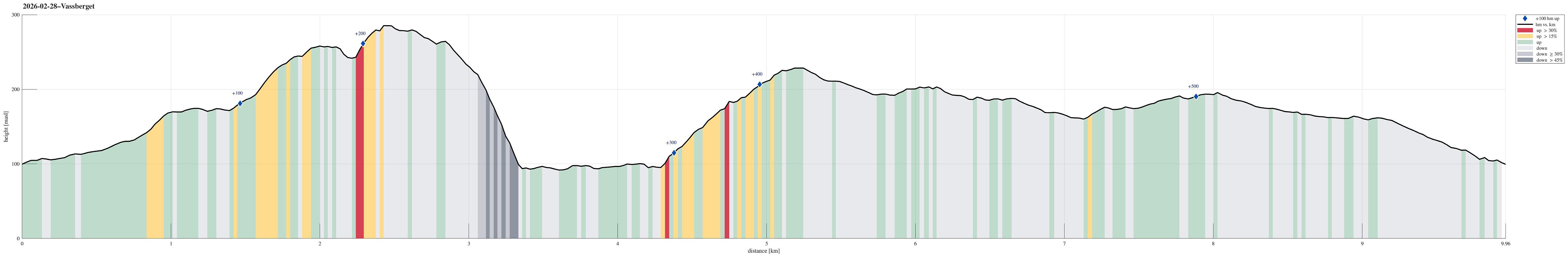 We expected a nice day and wished to make a nice, moderate hike with a chance to catch some sun, also. After first looking at Tveitavarden, Kvamsfjellet, and Vassberget, north of Knarvik, we then found a description of a hike over these hills, but in reverse order, providing additional motivation to explore this part of Alver. After driving there from Bergen, we parked right next to Lindåsvegen, where Årdalen comes down from the northwest. Walking up Årdalen, we then found the trail head for Vassberget, which is nicely marked with a sign. Following this trail, we quickly made it up the ridge in the southwest of Kråkstidalen, but instead of crossing over this valley (as the main trail does), we continued further northwards on the ridge (into the direction of Litlevassberget). At times and with some phantasy, >>>
Brøknipa from Båtaleitet (back via Borgasætra)
- Datum:
- 20.04.2025
- Tourcharakter:
- Wanderung
- Tourlänge:
- 4:00h
- Entfernung:
- 8,8km
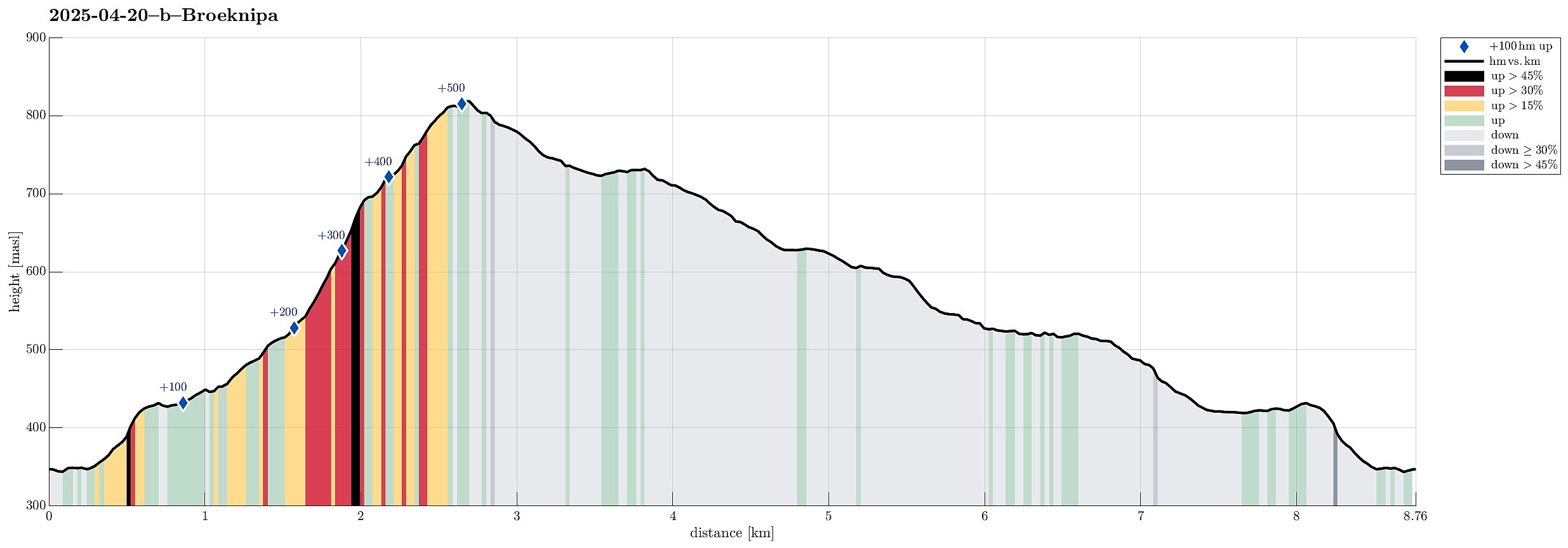 Probably it was about time to explore the new stone steps that had been laid down along the ascent path to Brøknipa (from Båtaleitet). We parked at the (now large) parking place at Båtaleitet (and paid our fee -- also that's new, as it seems). We then followed the main trail towards Brøknipa and the full parking lot had not fooled us: lots of others were on this trail, as well. While the project seems to be still ongoing, at least to some degree, significant parts of the ascent trail are now covered by impressive stone steps. Especially in the steepest section, up to Middagshaugen, this massively upgraded trail is now very impressive for sure! Enjoying the excellent views, already on our way up, we then made the "obligatory" short break on the top of Brøknipa, also taking >>>
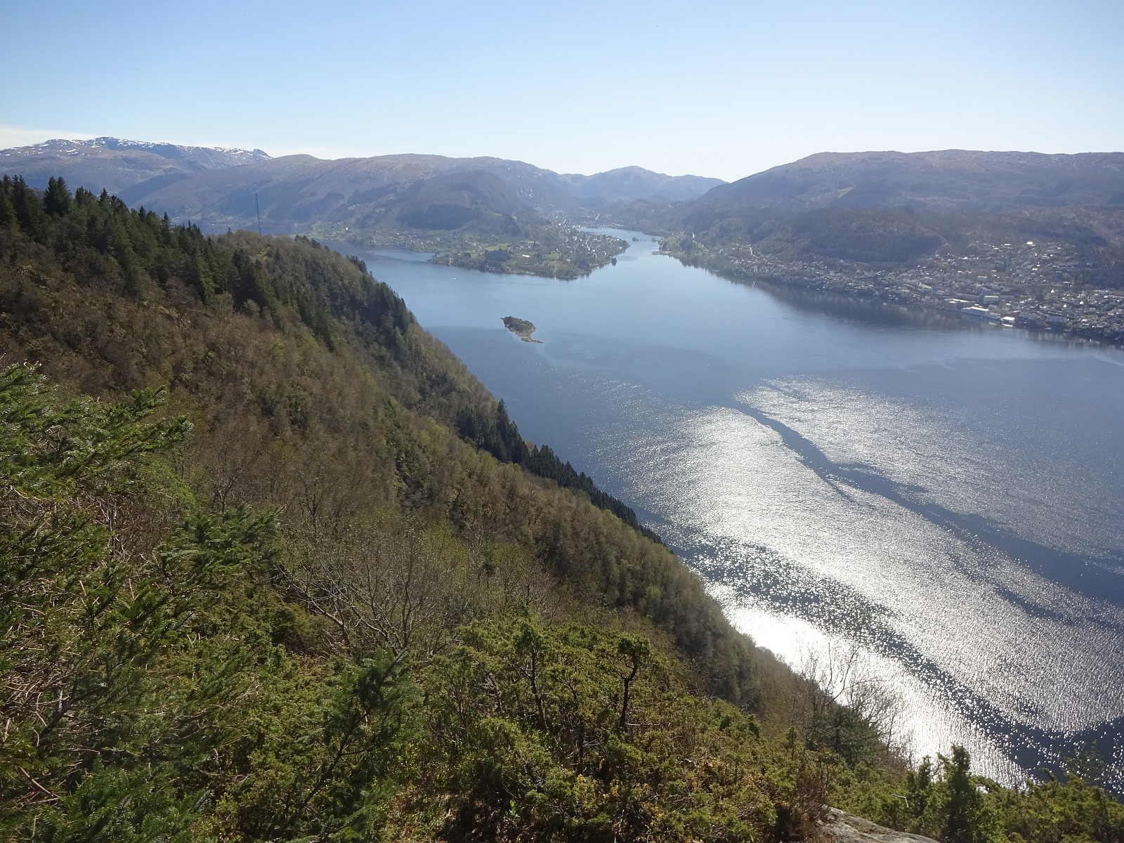
Towards Olsnesnipa from Olsneset
- Datum:
- 20.04.2025
- Tourcharakter:
- Bergtour
- Tourlänge:
- 1:30h
- Entfernung:
- 3,2km
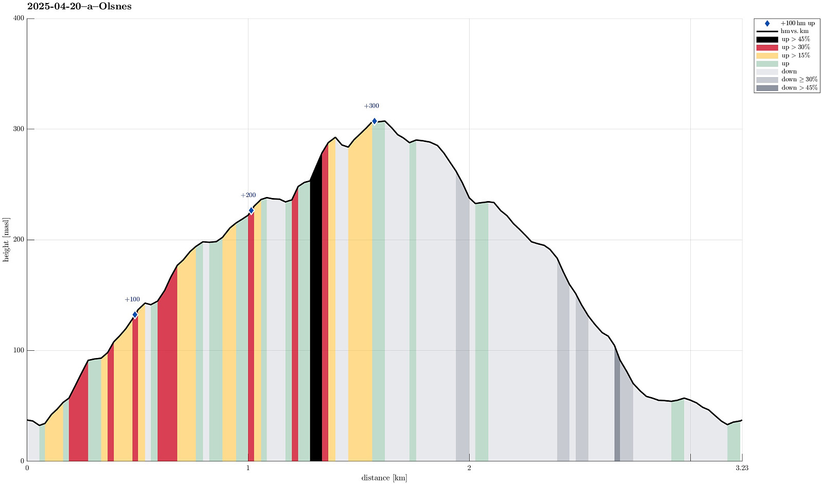 I was in the mood for a quick "before breakfast" stroll and thus headed to explore the heights north of Olsneset on Osterøy. After only a few meters it got confirmed that this would -- at least at large -- be an off-trail excursion. I still gained elevation relatively quickly, searching my way through the vegetation. Several times, I emerged at places with great views (including panoramic views across Sørfjorden -- nice!). Once up to about 240 masl, I got confronted with slightly more challenging terrain -- continuing "whereever" was no longer an option. After having made it down to the foot of an impressive cliff (in my west), I then followed this cliff upwards "right under it". This brought me to a place, where I could easily cross over to the heights, >>>
Hånipa from Reigstad
- Datum:
- 19.04.2025
- Tourcharakter:
- Bergtour
- Tourlänge:
- 2:30h
- Entfernung:
- 5,1km
 After taking the ferry from Breistein to Valestrand on Osterøy, we drove a bit further southwards and parked near Reigstad. We then followed the main trail across the northern ridge of Reigstadfjellet southwards to get up to Hånipa. We then continued along the high ridge, high above Sørfjorden, a bit more southwards, before turning left and descending into Reigstaddalen, following the main trail. Due to some major forest works, which had impacted the forest road through Reigstaddalen significantly, we then decided to follow Geitryggen instead of staying in the valley for getting back. About half way down, however, we still connected back with the forest road through Reigstaddalen. Somehow, without fully sinking into all the mud, we still made it back down and back to the car! :-) All >>>
Hananipa
- Datum:
- 09.02.2025
- Tourcharakter:
- Wanderung
- Tourlänge:
- 3:00h
- Entfernung:
- 6,5km
 We expected a nice day and tought that Hananipa would be a nice goal. In fact, we tought that making a nice round, including Raudnipa and/or Trollabotsvarden, would be a good idea. We drove out of Bergen into the direction of Voss and left road E16 at Trengereid to drive up to Nordre Skulstad. There, we parked and started our hike by heading towards Geitshushaugen, first, and then further up to Åsen, before connecting to Brunane. After following Brunane all the way up, we then continued up to Hananipa via its western ridge. Already at home, we had talked about the slightly steep section from Hananipa down to Sauaskaret; when then stepping towards this section, we concluded that we did not feel safe enough (with all the snow etc.). We thus turned around and headed back down the western >>>
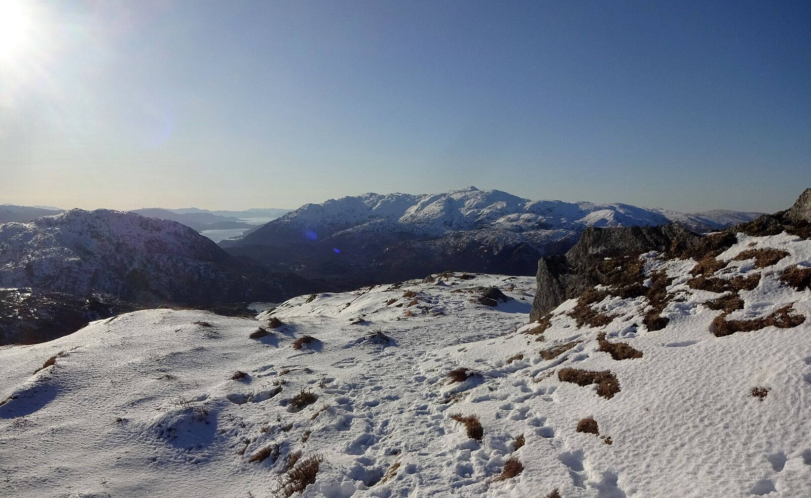
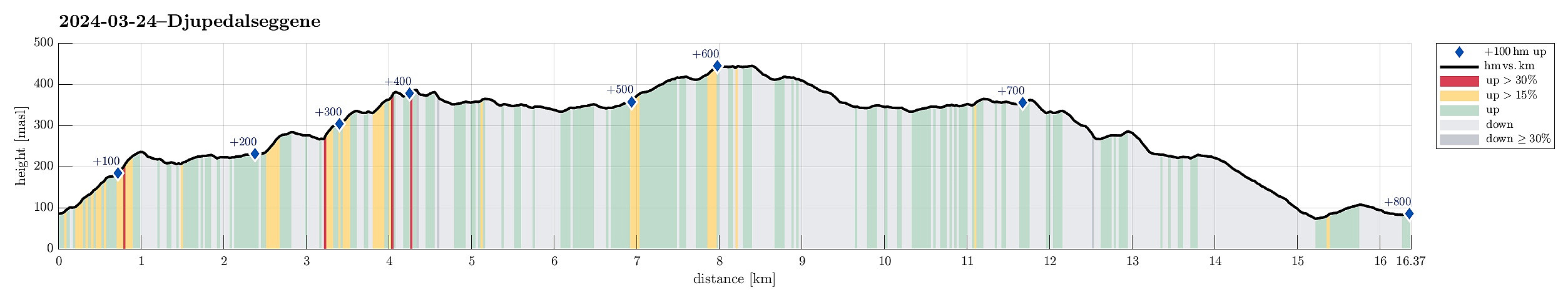
Djupedalseggene and Vindeggene from Ostereidet
- Datum:
- 24.03.2024
- Tourcharakter:
- Wanderung
- Tourlänge:
- 5:00h
- Entfernung:
- 16,4km
 We took the car from Bergen, first following E39 via Knarvik. From Osterfjordvegen, we then took a small road to Ostereidet, where we parked next to the local school. We started our hike up to Hovåsen, following first some forest roads and then a trail along the southeastern ridge of Hovåsen. From there, we then crossed over to the gravel road that leads up to Storset (via Bruarinden). After then walking up this gravel road to the end of the road at Storset, we then followed a marker that directed us to a small ridge in the south of Storsettjørna (and west of Vardhaugen). Crossing over this ridge (in northwestern direction) and stepping over the small stream that comes down from Storsettjørna (in southwestern direction), we ended up on the trail up to Vindeggene (this trail is not >>>
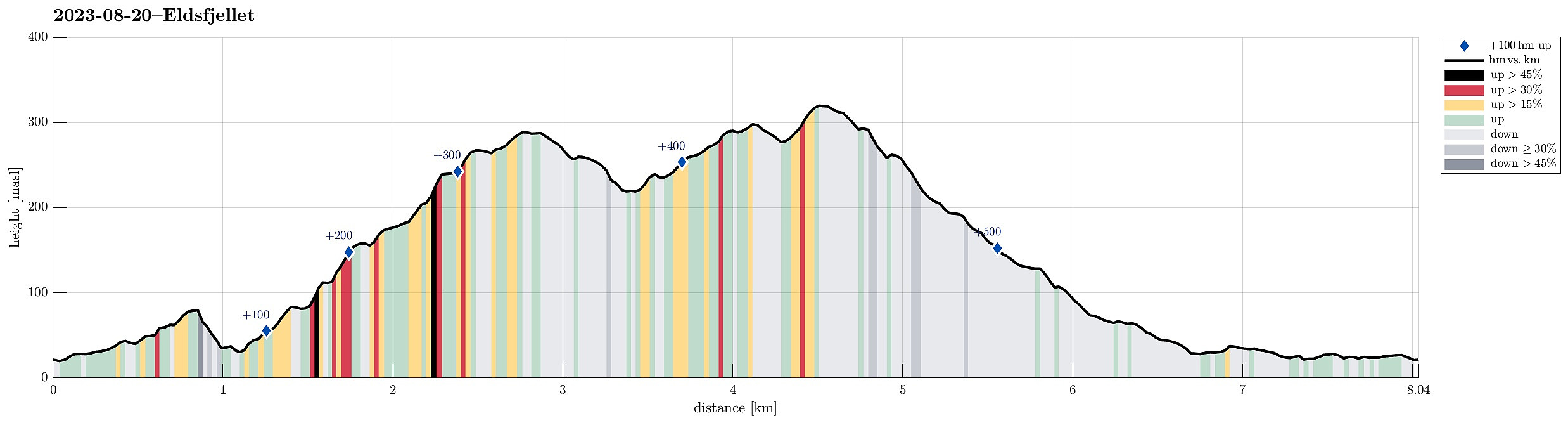
Eldsfjellet from the north
- Datum:
- 20.08.2023
- Tourcharakter:
- Wanderung
- Tourlänge:
- 4:00h
- Entfernung:
- 8,0km
 We had not been on Eldsfjellet for a while -- not the two of us, at least! Eldsfjellet is -- for good reasons -- a relatively popular hiking destination (it's not really high, as a mountain, but since it's standing out of its surrounding quite a bit, one can expect quite nice views from its heights). Here on Peakbook, as well as on other hiking platforms, one can easily get the impression that everyone (or "everyone") hikes up to Eldsfjellet from its south, either from the parking spot near Alvhøyen along Skjelangervegen, or from Skurtveit via Skurtveitvegen. Harald 's approach from the northwest is a notable exception, of course! :-) Even though it looked like off-trail a lot, we made a plan to approach Eldsfjellet from the north, instead. The idea was to follow Skjelangervegen further and around Eldsfjellet, >>>
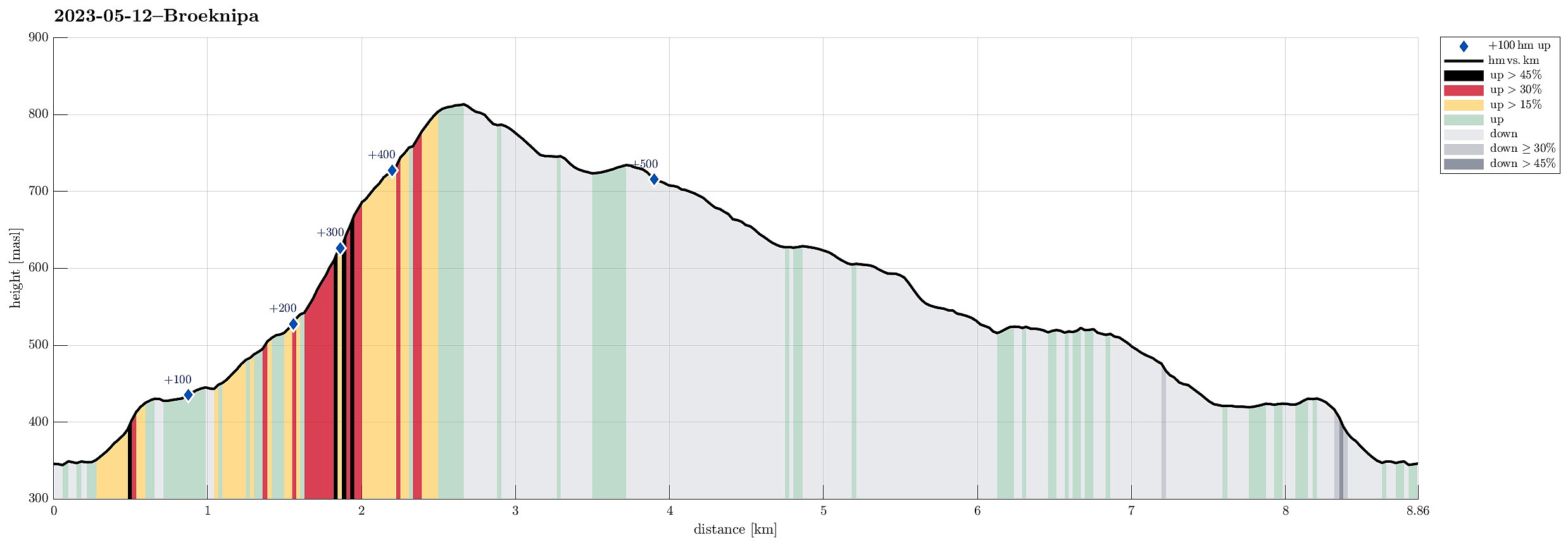
Brøknipa from Båtaleitet, back via Borgasærtra
- Datum:
- 12.05.2023
- Tourcharakter:
- Wanderung
- Tourlänge:
- 6:00h
- Entfernung:
- 8,9km
 We had the afternoon of this Friday at our disposal and the weather was looking OK. :-) To combine some mountain impressions with such of the fjords, we headed for Brøknipa on Osterøy, starting from Båtaleitet parking at about 350mosl. After driving to Osterøy via the bridge and then continuing further (along Sørfjorden) towards Bruvik, we headed up to the saddle and parked at Båtaleitet parking. Looking up to Brøknipa from there, we recognized that there was still quite a bit of snow left on the northern flank. We agreed to giving it a try, while being ready to turn around whenever anyone of us would feel like it. We followed the main trail that passes by Varmavatnet at about 425mosl. Also the following 100 height meters (in southern direction) were still easy and without much >>>
Stongfjellet and Skolmen
- Datum:
- 15.04.2023
- Tourcharakter:
- Wanderung
- Tourlänge:
- 4:30h
- Entfernung:
- 10,0km
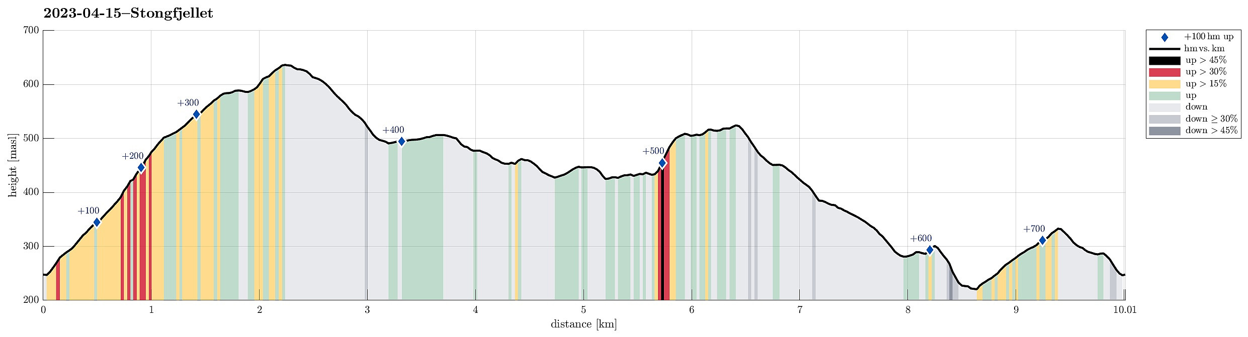 We first had considered Høgafjellet on Osterøy, but since we expected -- probably for good reasons -- quite a bit of snow on Høgafjellet, we eventually decided against Høgafjellet. Since we already thought about Osterøy, we chose Stongfjellet, instead. To get there, we drove to Osterøy (via the bridge to Osterøy), continuing through the tunnel on Osterøyvegen. At Gongerinden, we left Osterøyvegen, heading towards Gjerstad on Gjerstadvegen. Once through Gjerstad (and crossing over the stream), we continued via Solbjørg and Solbjørgsdalen. We then took Hovdavegen, passing by Låstadvatnet in its south and continuing further upwards in southeastern direction. Very close to the saddle, before reaching Hovdo at the end of the road, we parked right next to the trail-head. From Hovdavegen, >>>
Hæddena, Orrkleivhaugen, and Åsheimfjellet
- Datum:
- 04.03.2023
- Tourcharakter:
- Wanderung
- Tourlänge:
- 4:00h
- Entfernung:
- 8,2km
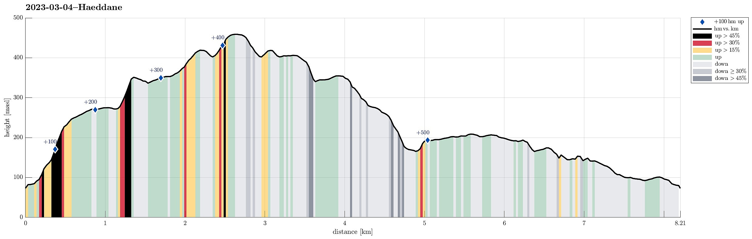 We thought that Osterøy would be nice for another hike and so we chose Hæddena right north of the bridge to Osterøy as our goal for the day. This time, however, we wished to get there via the nice-looking ridge, which is directly about the long tunnel of Osterøyvegen (basically the continuation of the bridge). The map had suggested that a simple trail should be leading up there, as well. We parked right after driving through "the other tunnel" (of Hausvegen, "only" some 150m long, or so) and aimed at taking this trail up to the ridge. In order to do so, one should first follow the northbound trail (into the direction of Haus) up to Vikno (or almost all the way there), before then turning around and up a gentle ridge. Instead, we turned right way earlier, ending >>>
