Archiv - Nach Datum
Archiv - Nach Aktivität
-
Andere Tour (1)
- Kayaking (1)
-
Andere Wintertour (4)
- Schneeschuhtour (4)
-
Fahrradtour (137)
- Fahrradtour Straße (9)
- Fahrradtour gemischt (51)
-
Fußtour (740)
- Bergtour (363)
- Jogging (18)
- Spaziergang (89)
- Wanderung (270)
-
Skitour (4)
- Tourenskilauf (4)
Archiv - Nach Geografie
Peakbookfreunde


Gesammelte Listen
-
Bergen ≥ 50m pf. og ≥ 100 m.o.h.
(87/89)
 97%
97% -
Most dominating tops of the Bergen peninsula
(68/75)
90%
-
Utvalgte topper og turmål i Bergen
(316/350)
90%
-
Alle topper i Bergen
(357/398)
89%
-
Opptur Bergen
(100/113)
88%
-
De syv fjell rundt Bergen
(6/7)
85%
-
Sund ≥ 50m pf.
(14/18)
77%
-
Os ≥ 50m pf.
(25/34)
73%
-
Søyler (fastmerker) i Bergen
(68/100)
68%
-
Fjell ≥ 50m pf.
(21/32)
65%

To Bergen and back
- Datum:
- 18.07.2020
- Tourcharakter:
- Bergtour
- Tourlänge:
- 6:00h
- Entfernung:
- 19,8km
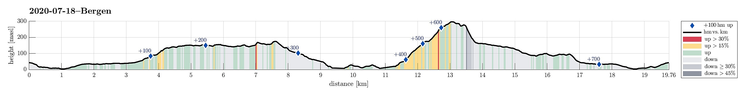 Walking up Fyllingsdalen and further to Bergen. Enjoying a beer, or two. Walking back. Not much more to write, this time. :-)
See also the related FB-page Hiking around Bergen, Norway .
Walking up Fyllingsdalen and further to Bergen. Enjoying a beer, or two. Walking back. Not much more to write, this time. :-)
See also the related FB-page Hiking around Bergen, Norway .
Visiting Kavlane from Kallestad
- Datum:
- 11.07.2020
- Tourcharakter:
- Wanderung
- Tourlänge:
- 5:00h
- Entfernung:
- 12,2km
 Hoping for a bit of OK weather, we aimed at the islands in the west of Bergen. Road 555 brought us to Sotra, where we turned south. Passing by Fjell and continuing along road 555 into the direction of Hammarsland, we turned right after Dalseidet, taking road 203 towards Kallestad. There, we parked right next to Grendahuset, starting our hike from there, passing by a few of the houses of Kallestad before getting "out into the wild", west of Kallestad. While the first meters past the last house are still on a kind of gravel road, this quickly changes into a nicely marked trail (Nordsjøløypen), which passes by Stølstjørna (in its southwest), then turning westwards, again, leading through a minor valley to Kjereidet. There, Kørelen (in the south) empties into Kjereidosen (in >>>
Skåldalsfjellet from Bjørndalen
- Datum:
- 04.07.2020
- Tourcharakter:
- Wanderung
- Tourlänge:
- 3:30h
- Entfernung:
- 8,1km
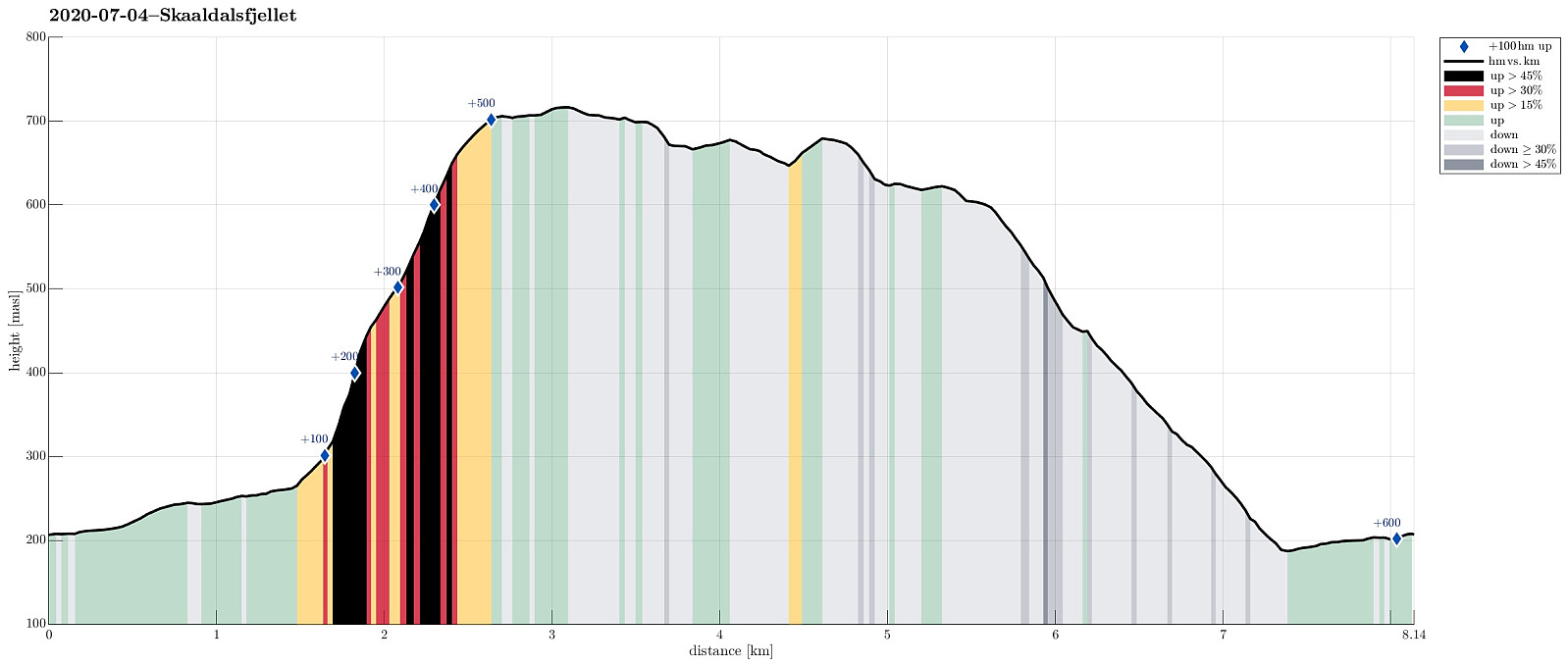 We drove past Grimevatnet and Haukelandsvatnet into the direction of Osavatnet near Gullfjellet, but stopped next to Gullfjellsvegen where the road crosses a small saddle between Ramsdalshovden in the east and Vemånen in the west to continue along Skåldalselva from there. Leaving our car behind, we continued along this road walking, first around Ramsdalshovden on the right (south) and then around Hjelterinden on the left (north). At Søre Bjørndalen, we used a bridge which leads over Skåldalselva to a few houses on the north-side of the valley. Once on this other side, there, we continued first further along a simple road (passing by Nordre Bjørndalen), before starting our actual ascent to Skåldalsfjellet via Høgrusten. On Norgeskart, we had seen that -- while not on a trail -- it >>>
Kofta (and Gullfjellet) from Nordbø
- Datum:
- 20.06.2020
- Tourcharakter:
- Wanderung
- Tourlänge:
- 6:00h
- Entfernung:
- 12,6km
 For at least two years, already, we had (occasionally) considered this hike: Kofta from Nordbøbotnen. After a relaxing morning, and knowing that the days are (very) long at this time of the year, we decided to go and do it. We drove from Bergen (via E16 first, then across Gullbotn) and left road #7 right after Hisdalstunnelen (to the right), where it leads on into the direction of Osøyro. Driving down road #137 for only a short stretch, we came to Nordbø, where we turned right (again), now in northern direction. From there, we continued for just about 850m, or so, until we had passed the last house. There, before entering the forest, we parked next to the road. We first walked along the forest road (the same road that we had come in with the car further down) up to about 200mosl (only >>>
Storenuten and Vardane
- Datum:
- 14.06.2020
- Tourcharakter:
- Wanderung
- Tourlänge:
- 4:30h
- Entfernung:
- 9,3km
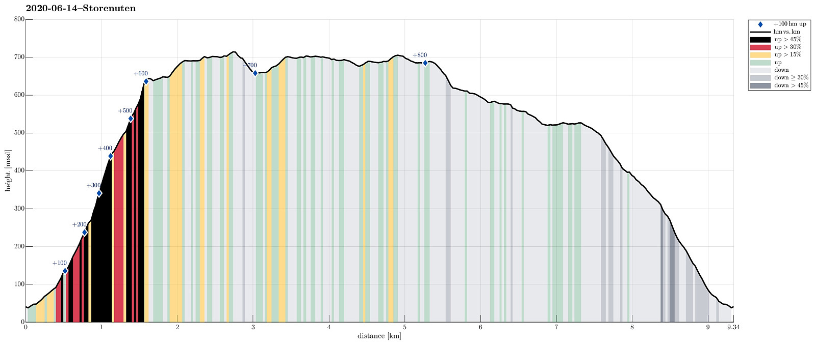 We expected (for good reasons) a nice Sunday and thus aimed at a nice (new) hike! We had looked at Storenuten, south of Vaksdal, not very far from Bergen. Taking road E16 into the direction of Voss, we turned right in Vaksdal, after driving through Bogatunnelen. We then rounded Sørbø, in the south of Vaksdal, passing by the non-small church of Vaksdal. We then followed what previously must have been the main road to Bergen in southern direction, getting to Bogo within a bit. At Ytre Bogo we parked along Bogavegen and started our hike there. After a careful study of the map (at home), we aimed for Storenuten "as directly as possible". This, clearly, is non-trivial, without a trail, and should be planned carefully when considered! Alternatively, one may follow a nice trail, >>>
Kanadaskogen
- Datum:
- 13.06.2020
- Tourcharakter:
- Bergtour
- Tourlänge:
- 3:00h
- Entfernung:
- 8,7km
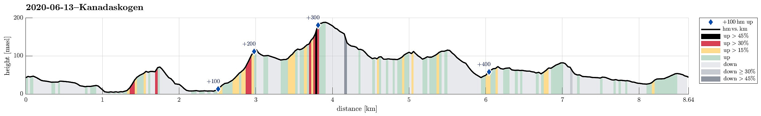 With only limited time at our disposal, we "simply" headed for Kanadaskogen. Passing by Gjeddevatnet (coming from Varden), we stepped upwards from Gjerdsvika. This time, we included Allestadhaugen (between Hesjaholten and Bjørndalsvatnet), before descending to the eastern side of Bjørndalsvatjnet. At the very northern end of Bjørndalsvatnet, where one still finds the remains of some former building, we followed the valley upwards (in northern direction), but just 25 height meters, or so. There, we turned left, first following a trail for a short while, before then continuing "straight" upwards to Træshovden through the forest. At Træshovden, we decided the Svartaberget make up a nice next goal (and off we headed there). Due to its very steep western side, Svartaberget >>>
Nonkletten and Storavika on Korsneset
- Datum:
- 30.05.2020
- Tourcharakter:
- Bergtour
- Tourlänge:
- 2:30h
- Entfernung:
- 7,8km
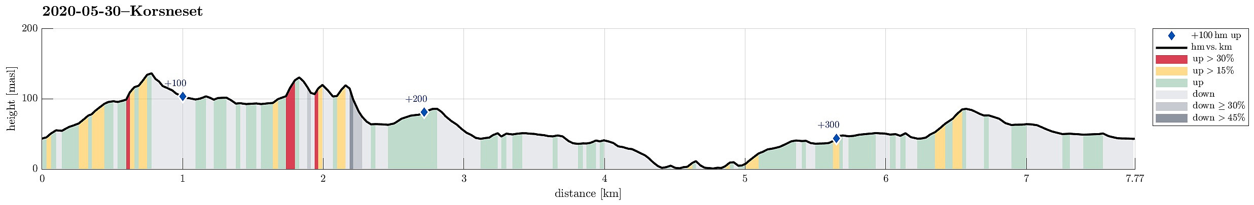 With limited time available, and a nice, warm, and sunny day, we decided to make a medium-long hike on Korsneset with nice Storavika as our main trip goal. Driving by Krokeide and continuing further onto Korsneset, we continued all the way to the junction east of Tverrhaugen, where parking is conveniently possible. Before heading towards Storvika, we wished to include Nonkletten, northeast of the parking place. We thus walked for a few meters back the road that we had come. Maybe some 200m into this, we turned left onto a proper trail, leaving in northwards direction. This trail leads nicely upwards to a nice minor hill in the west of Nonkletten. There, on a minor saddle at about 95mosl, we decided to leave the trail and head eastwards into the direction of Nonkletten. Even though one >>>
Evening Løvstakken
- Datum:
- 26.05.2020
- Tourcharakter:
- Bergtour
- Tourlänge:
- 1:30h
- Entfernung:
- 4,6km
 Spontaneously, we decided to do a quick after-work sprint up Løvstakken (the steep way). We parked near the SPAR shop "Sikthaugen" (above Sikthaugen Terrasse) and walked up the pedestrians' connection to Kirsten Flagstads vei. From there, we continued along Rosenlundveien (up to house 43), before taking the trail that ascends steeply underneath the power line in Eastern direction. At about 350mosl, the steepest part of the trail starts (roughly in Northern direction). A bit more the 50 meters higher, one comes out and can enjoy some nice views over Fyllingsdalen. From there, it's then "just" following the trail all to the top of Fyllingsdalen. Definitely a nice alternative of an ascent to Løvstakken! From the top, we then followed the Northern ridge down (into the >>>
Tåkenuten and Kråkenos
- Datum:
- 23.05.2020
- Tourcharakter:
- Wanderung
- Tourlänge:
- 6:15h
- Entfernung:
- 13,4km
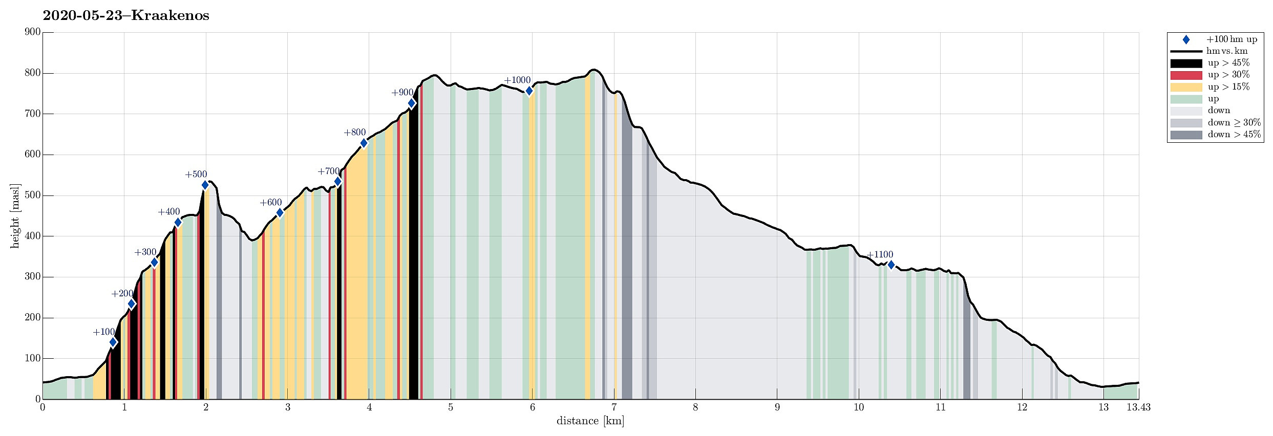 Weighing the weather forecast with our wish to make a nice hike, we ended up with Kråkenos as our hiking goal. While this mountain is also well accessible from its eastern side (from Bru near Strandebarm at Hardangerfjorden), we decided to approach it from its western side, i.e., from Øvre Hålandsdalen. To get there, we drove from Bergen first along E16 into the direction of Voss, then along road 49 into the direction of Kvamskogen, before then continuing along road 48 to Eikelandsosen and from there further towards Holdhus a few kilometers in the east of Eikelandsosen. Near Holdhus one needs to take a sharp turn to the left (north) onto an old and narrow road that leads into Øvre Hålandsdalen (after first passing between Gjønavatnet in the north and Skogseidvatnet in the south). >>>
Tunesfjellet and Skåldalsfjellet
- Datum:
- 21.05.2020
- Tourcharakter:
- Wanderung
- Tourlänge:
- 4:30h
- Entfernung:
- 12,2km
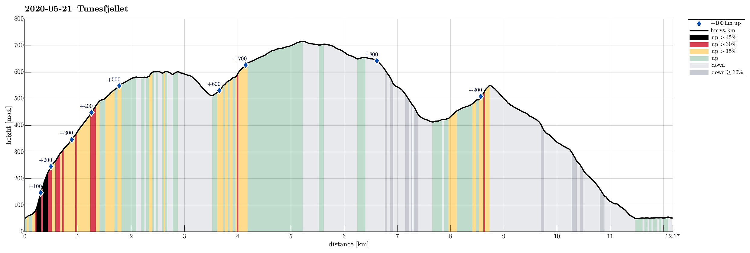 One could say that this hike is a logical continuation of our small research project Gullfjellet from the north, Sørfjorden . :-) We drove from Bergen to Arna and then through the tunnel under Ådnanipa (E16), before taking the very first exit ("Takvam") and turning back along the old road (Tunesvegen) into the direction of Tunes. At Tunestveit, only a few meters from the E16-exit, we parked along the road. We then crossed under E16 (right where it comes out of the tunnel under Ådnanipa, crossing over Tveitaelva there) and continued on an old forest road into the direction of Åsen. All the terrain is very steep there and most parts will not provide any opportunity to continue all the way up. Our map study, however, had suggested that ascending to Åsen on the very eastern side >>>
