Archiv - Nach Datum
Archiv - Nach Aktivität
-
Andere Tour (1)
- Kayaking (1)
-
Andere Wintertour (4)
- Schneeschuhtour (4)
-
Fahrradtour (123)
- Fahrradtour Straße (5)
- Fahrradtour gemischt (41)
-
Fußtour (736)
- Bergtour (363)
- Jogging (18)
- Spaziergang (88)
- Wanderung (267)
-
Skitour (4)
- Tourenskilauf (4)
Archiv - Nach Geografie
Peakbookfreunde


Gesammelte Listen
-
Bergen ≥ 50m pf. og ≥ 100 m.o.h.
(87/89)
 97%
97% -
Most dominating tops of the Bergen peninsula
(68/75)
90%
-
Utvalgte topper og turmål i Bergen
(313/347)
90%
-
Alle topper i Bergen
(356/398)
89%
-
Opptur Bergen
(100/113)
88%
-
De syv fjell rundt Bergen
(6/7)
85%
-
Sund ≥ 50m pf.
(14/18)
77%
-
Os ≥ 50m pf.
(25/34)
73%
-
Søyler (fastmerker) i Bergen
(68/100)
68%
-
Fjell ≥ 50m pf.
(21/32)
65%

Round around Fyllingsdalen
- Datum:
- 03.04.2026
- Tourcharakter:
- Fahrradtour gemischt
- Tourlänge:
- 4:00h
- Entfernung:
- 27,5km
 With a prediction of rain in the early afternoon, we decided to just cycle a little (towards Bergen and back), instead of aiming for a mountain top. First, we headed northwards along Bjørgeveien. Instead of cycling directly to Bjørndalen, however, we decided to make a simple detour around Bjørndalspollen, taking advantage of the little bridge at Hetlevikstraumen. At Loddefjord, we turned right and continued towards Laksevåg on the southeasern side of Lyderhorn (along Liavatnet). In the north of Holefjellet, we then parked our bikes for a few minutes to walk up to Noven and take a look at the historic relics from WWII there. Especially in times, when war seems to become "normal" again, it's moving particularly to be reminded of the major catastrophy that unfolded when a four-digit >>>
Høgstefjellet and Tellevikafjellet
- Datum:
- 02.04.2026
- Tourcharakter:
- Wanderung
- Tourlänge:
- 4:00h
- Entfernung:
- 9,4km
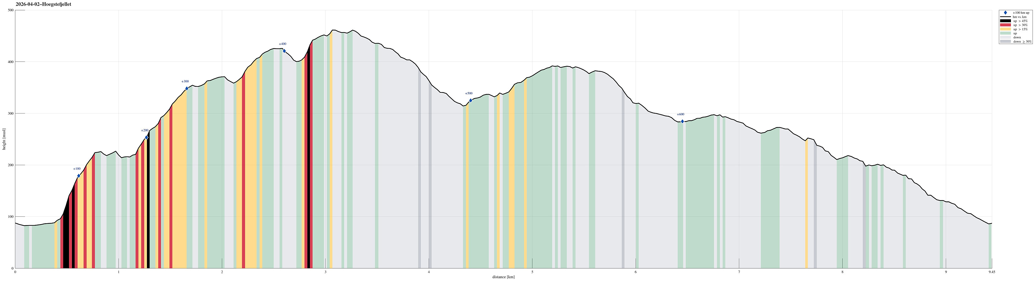 We expected a nice day and wished to make a nice hike without getting into too deep (wet) snow. The round around Baugtveitstemma, including Høgstefjellet and Tellevikafjellet, seemed just right. We found a place to leave the car behind near Salhusvegen, where one turns to towards Hitland and Baugtveit (further up the road). The original plan was to head eastwards, first, to get to a trail, which leads up to Huseberget from Salhusvegen. One from Hitland, however, was determined to avoid us going there (because of some sheep on the eastern side of Hitland). This required making up a plan B, which then basically was to ascend to Huseberget from the west (instead of from the south). Without having prepared this carefully at home, first, however, and knowing (and seeing) how steep Huseberget >>>
Allestadhaugen
- Datum:
- 30.03.2026
- Tourcharakter:
- Bergtour
- Tourlänge:
- 1:00h
- Entfernung:
- 4,4km
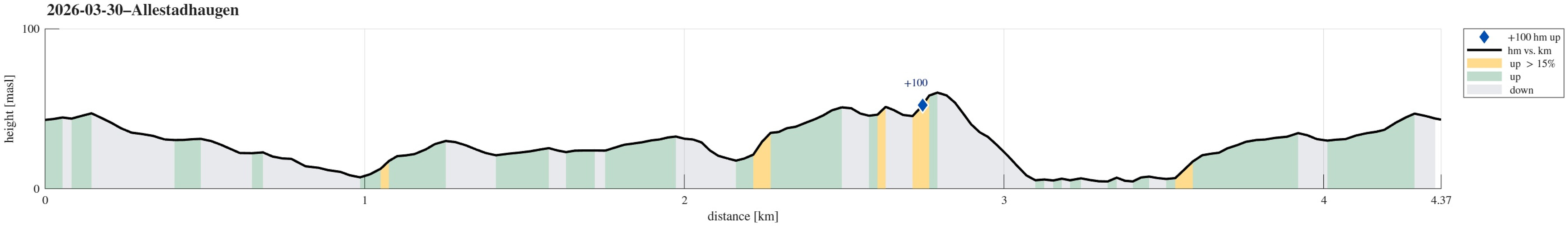 Even though the weather was not perfect, we still wished to get some fresh air. After first walking around Varden, we then followed the new (and partially finished) walking trail in the northwest of the soccer fields. From there, it was then just a short round up and down Allestadhaugen, before we headed back along Gjeddevatnet.
See also the related FB-page Hiking around Bergen, Norway .
Even though the weather was not perfect, we still wished to get some fresh air. After first walking around Varden, we then followed the new (and partially finished) walking trail in the northwest of the soccer fields. From there, it was then just a short round up and down Allestadhaugen, before we headed back along Gjeddevatnet.
See also the related FB-page Hiking around Bergen, Norway .
Round around Nordåsvatnet
- Datum:
- 28.03.2026
- Tourcharakter:
- Fahrradtour gemischt
- Tourlänge:
- 3:00h
- Entfernung:
- 23,8km
 Without a particular goal in mind, we just thought that biking around Nordåsvatnet could be nice. After first heading south, in the west of Sælevatnet, we then crossed over Straume to Søreide, where we took a look a the church (just from the outside). Cycling up via Karlsmarka to connect to Dolvikvegen was an unusual alternative, then. Next, we had the idea to explore Søvika a little. Once back on Steinsvikvegen, we then followed "the usual track" around Steinsvika. We then connected to Nordåsvegen, but not via the usual connection (that's a bit higher up), but via Nordåsbrotet. Next was to cycle down to Skjoldabukta before it was up again along Harald Skjolds veg. Via Skjoldvegen and Sundts veg, we then got to Hopsåsen, which also was unusual as a connection to Troldhaugvegen. >>>
Round around Fyllingsdalen
- Datum:
- 07.03.2026
- Tourcharakter:
- Fahrradtour gemischt
- Tourlänge:
- 1:45h
- Entfernung:
- 27,3km
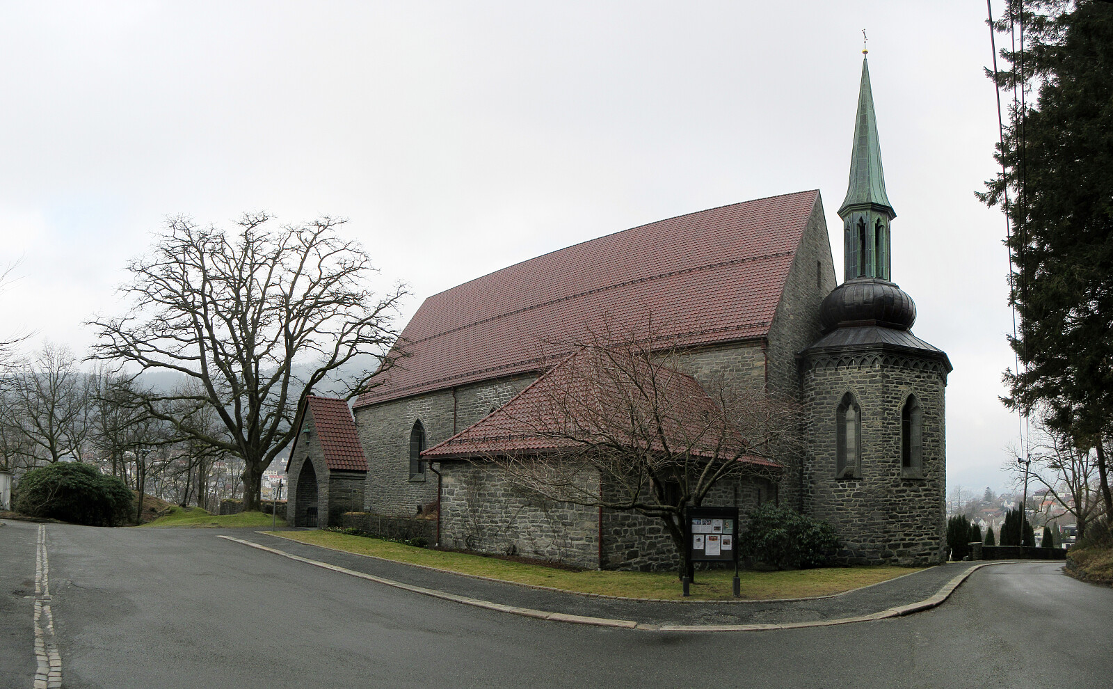 Was man nicht im Kopf hat, hat man (hoffentlich) in den Beinen, sagt man. I had left something at work, which I wished to use, and since the weather was quite OK, I thought that I could combine the necessary with some biking. I started by surrounding Bønes on its south (north of Nordåsvatnet), heading eastwards. North of Gamlehaugen, when arriving at Fjøsanger, I decided that I could visit Storetveit kirke, which I had seen numerous times while biking either to or from work, but never really visited up-close. Then, I continued further northwards towards the center of Bergen. After picking up my stuff, I then thought that I could equally well continue this "round around Fyllingsdalen", aiming at Laksevåg, next. After passing over Nygårdshøyden and Puddefjordsbroen, I then >>>
Morvikavarden, Olderhaug, and Geitanuken
- Datum:
- 01.03.2026
- Tourcharakter:
- Wanderung
- Tourlänge:
- 3:00h
- Entfernung:
- 7,6km
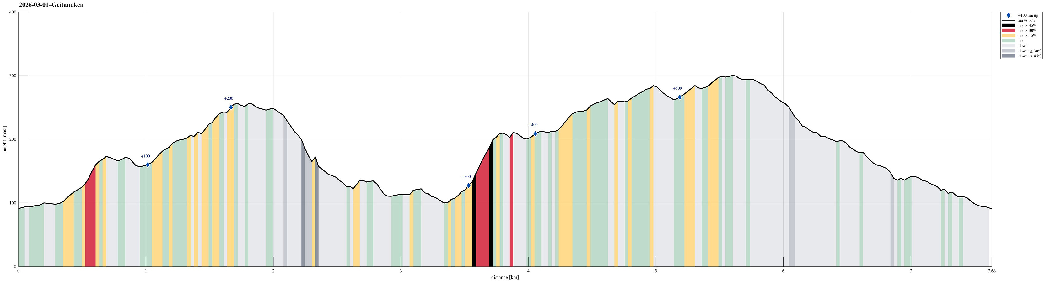 With also this Sunday inviting us to get some fresh air, we decided to visit Geitanuken again, while making it a round (an elongated one) from/to Åsane. We parked right next to Myrdalsvegen, not far from Åsane Arena, and then headed into the direction of Stornipa, first. In the northwest of Åsane Arena, we then also found a way to get over and into the forest. Stepping up to Stornipa was then just a question of a few minutes and the forest is actually quite nice there. Next, we wished to explore Morvikavarden and to get there, we crossed over Stornipa to connect with road Myrdalskogen in the north. On the northwestern side of "the big bend" of Myrdalskogen, we found an opportunity to "short-cut" further upwards through the forest. After yet again walking along Myrdalskogen >>>
Vassberget, Kvamsfjellet, and Tveitavarden
- Datum:
- 28.02.2026
- Tourcharakter:
- Wanderung
- Tourlänge:
- 4:00h
- Entfernung:
- 10,0km
 We expected a nice day and wished to make a nice, moderate hike with a chance to catch some sun, also. After first looking at Tveitavarden, Kvamsfjellet, and Vassberget, north of Knarvik, we then found a description of a hike over these hills, but in reverse order, providing additional motivation to explore this part of Alver. After driving there from Bergen, we parked right next to Lindåsvegen, where Årdalen comes down from the northwest. Walking up Årdalen, we then found the trail head for Vassberget, which is nicely marked with a sign. Following this trail, we quickly made it up the ridge in the southwest of Kråkstidalen, but instead of crossing over this valley (as the main trail does), we continued further northwards on the ridge (into the direction of Litlevassberget). At times and with some phantasy, >>>
Nice round around Småvatnet near Alvøen
- Datum:
- 21.02.2026
- Tourcharakter:
- Spaziergang
- Tourlänge:
- 2:00h
- Entfernung:
- 6,6km
 There was an idea of spring in the air and so we decided to make a round around Småvatnet near Alvøen. We parked in the north, right next to Alvøveien, not far from the soccer fields there. To get south towards Småvatnet, we first crossed over Ospehaugen. Further south, we then started our round around the lake by exploring the small peninsular in the west of Slettebakksvika. Next was then to walk around Slettebakksvika and heading further south on the east-side of Småvatnet. This stretch is a bit interesting, since one has to find a way to get through (with quite some cliffs connecting more or less directly to Småvatnet). Since we had done this before, we knew that it could be done, and so it was without difficulties that we made it to Gullaksdalen. From there, we then followed >>>
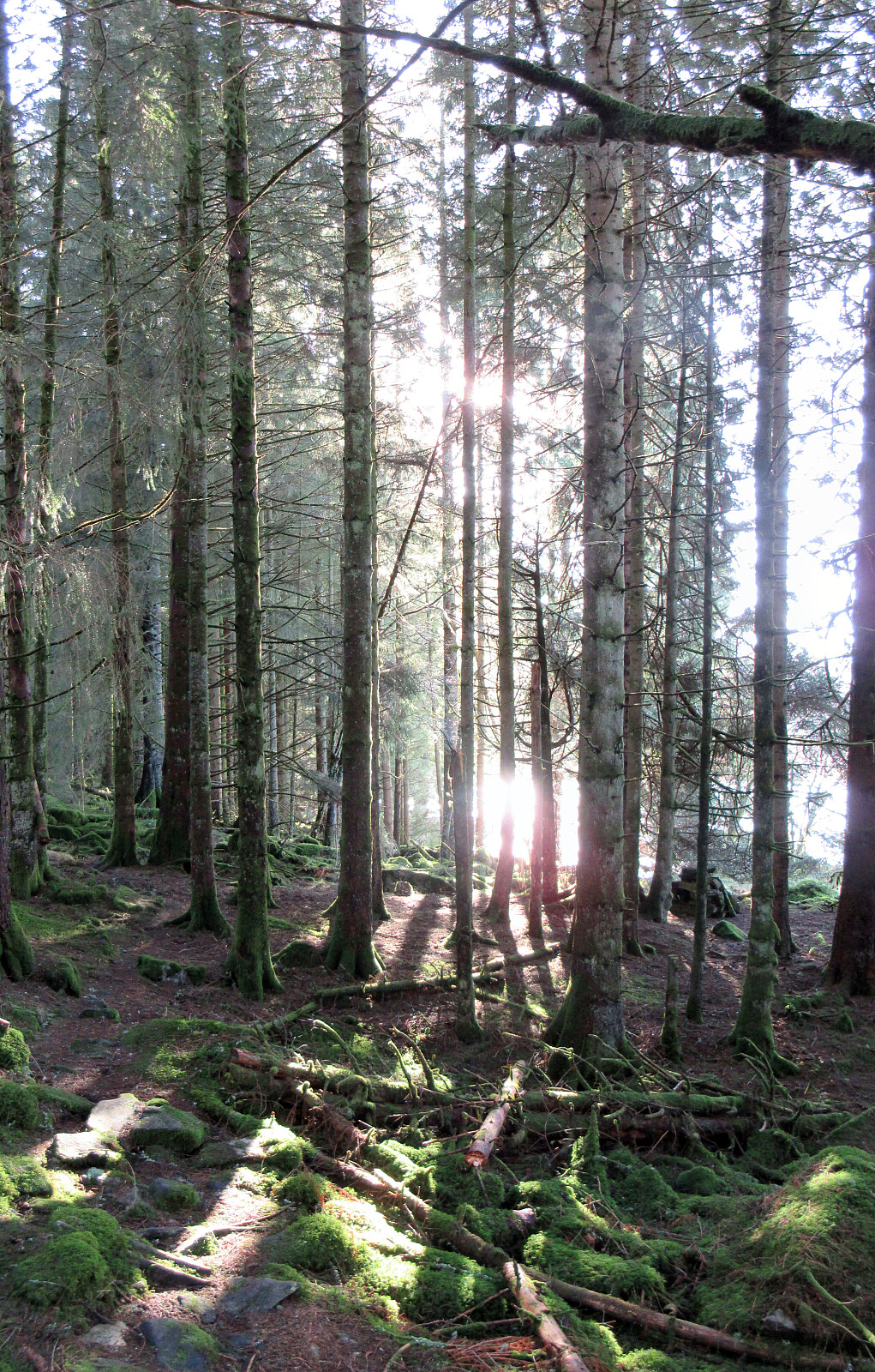
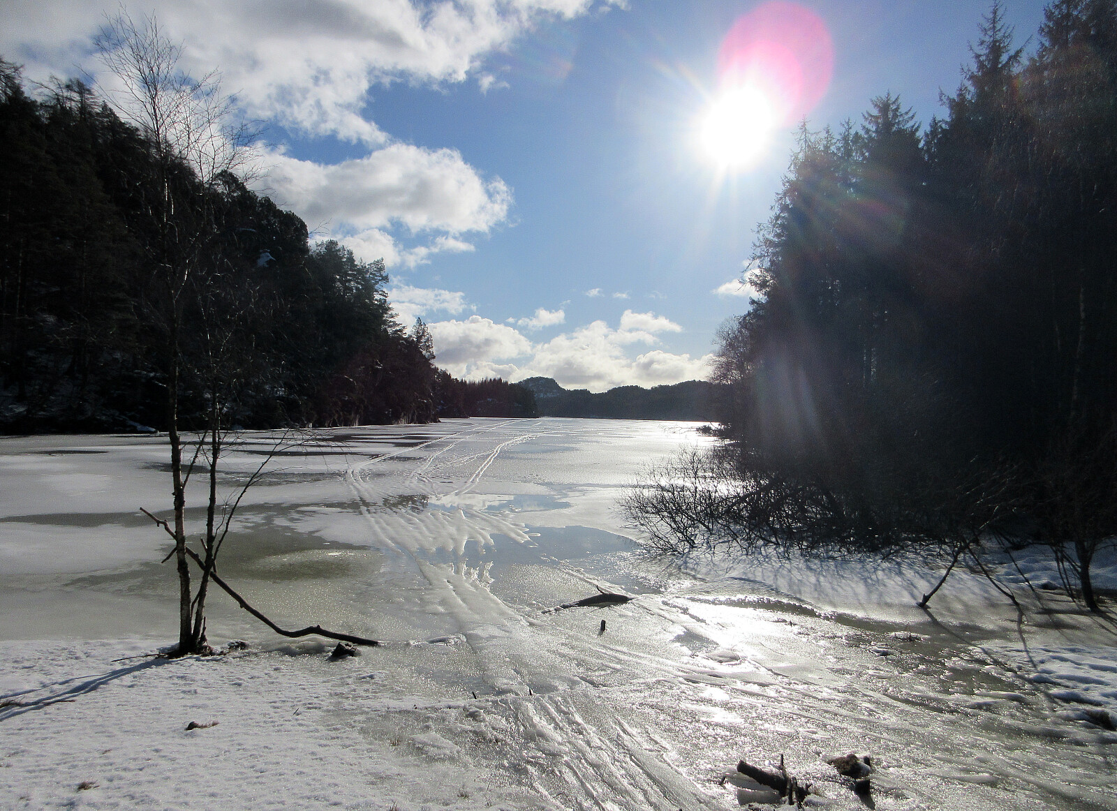
Skiing Bildøybakken
- Datum:
- 14.02.2026
- Tourcharakter:
- Tourenskilauf
- Tourlänge:
- 2:00h
- Entfernung:
- 5,2km
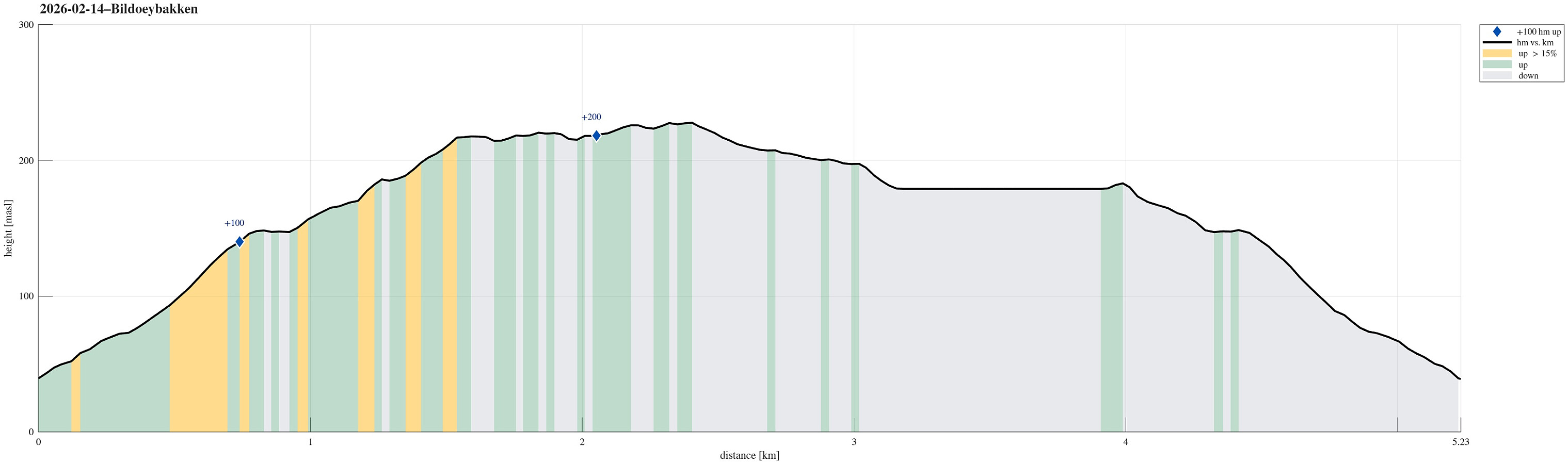 With new snow outside, we decided to take our skies and head towards Bildøybakken for an excursion into the snow. We parked at the lower end of the road which leads up to the dam of Bildøyvatnet, then following this road up to the dam. From there, we then ascended to Bildøyfjellet. Then, we continued across the heights of Bildøybakken (southwards to Vardafjellet). We then decided to connect to the southern end of Bildøyvatnet in order to cross it (on skies) south-to-north. This worked just fine and it did not take us all to long before we were back where we had started the afternoon.
Selected photos are available as Google photo album .
See also the related FB-page Hiking around Bergen, Norway .
With new snow outside, we decided to take our skies and head towards Bildøybakken for an excursion into the snow. We parked at the lower end of the road which leads up to the dam of Bildøyvatnet, then following this road up to the dam. From there, we then ascended to Bildøyfjellet. Then, we continued across the heights of Bildøybakken (southwards to Vardafjellet). We then decided to connect to the southern end of Bildøyvatnet in order to cross it (on skies) south-to-north. This worked just fine and it did not take us all to long before we were back where we had started the afternoon.
Selected photos are available as Google photo album .
See also the related FB-page Hiking around Bergen, Norway .
Marmorøyen, Flatøyna, and Ulvøyna
- Datum:
- 08.02.2026
- Tourcharakter:
- Bergtour
- Tourlänge:
- 1:30h
- Entfernung:
- 5,0km
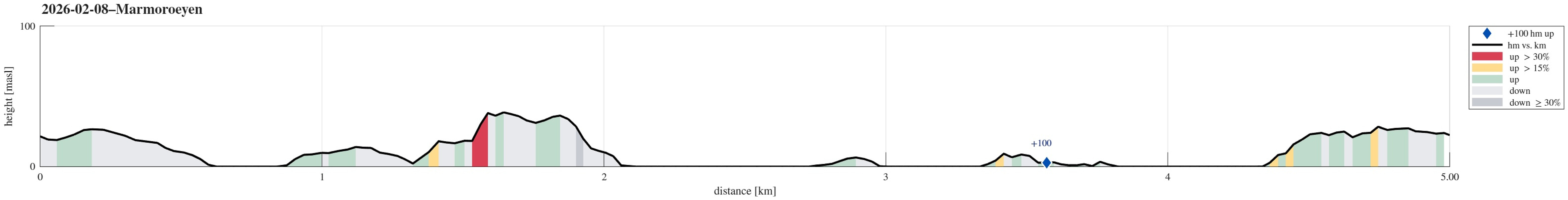 With everthing still frozen, we thought that it could work to simply walk over to Marmorøyen in Nordåsvatnet. We parked near Troldhaugen and approached the ice via Frants Beyers veg. While the ice on top of Nordåsvatnet indeed was thick and sturdy, it wasn't all trivial to get onto it -- due to the tides, the ice was broken up near the shore. One attempt to get onto the ice right at the beginning then ended up with breaking into the water right away (just with one leg). After finding a better spot, it then worked without problems. This little mishap in the beginning, however, resulted in the decimation of the walking team (from three down to two). Once on the ice, the next question was where a good "landing place" would be on Marmorøyen. Heading a bit outwards of Marmorsundet >>>
