Archiv - Nach Datum
Archiv - Nach Aktivität
-
Andere Tour (1)
- Kayaking (1)
-
Andere Wintertour (4)
- Schneeschuhtour (4)
-
Fahrradtour (137)
- Fahrradtour Straße (9)
- Fahrradtour gemischt (51)
-
Fußtour (740)
- Bergtour (363)
- Jogging (18)
- Spaziergang (89)
- Wanderung (270)
-
Skitour (4)
- Tourenskilauf (4)
Archiv - Nach Geografie
Peakbookfreunde


Gesammelte Listen
-
Bergen ≥ 50m pf. og ≥ 100 m.o.h.
(87/89)
 97%
97% -
Most dominating tops of the Bergen peninsula
(68/75)
90%
-
Utvalgte topper og turmål i Bergen
(316/350)
90%
-
Alle topper i Bergen
(357/398)
89%
-
Opptur Bergen
(100/113)
88%
-
De syv fjell rundt Bergen
(6/7)
85%
-
Sund ≥ 50m pf.
(14/18)
77%
-
Os ≥ 50m pf.
(25/34)
73%
-
Søyler (fastmerker) i Bergen
(68/100)
68%
-
Fjell ≥ 50m pf.
(21/32)
65%

Jordalsnuten from Jordalen
- Datum:
- 25.08.2018
- Tourcharakter:
- Bergtour
- Tourlänge:
- 3:30h
- Entfernung:
- 5,8km
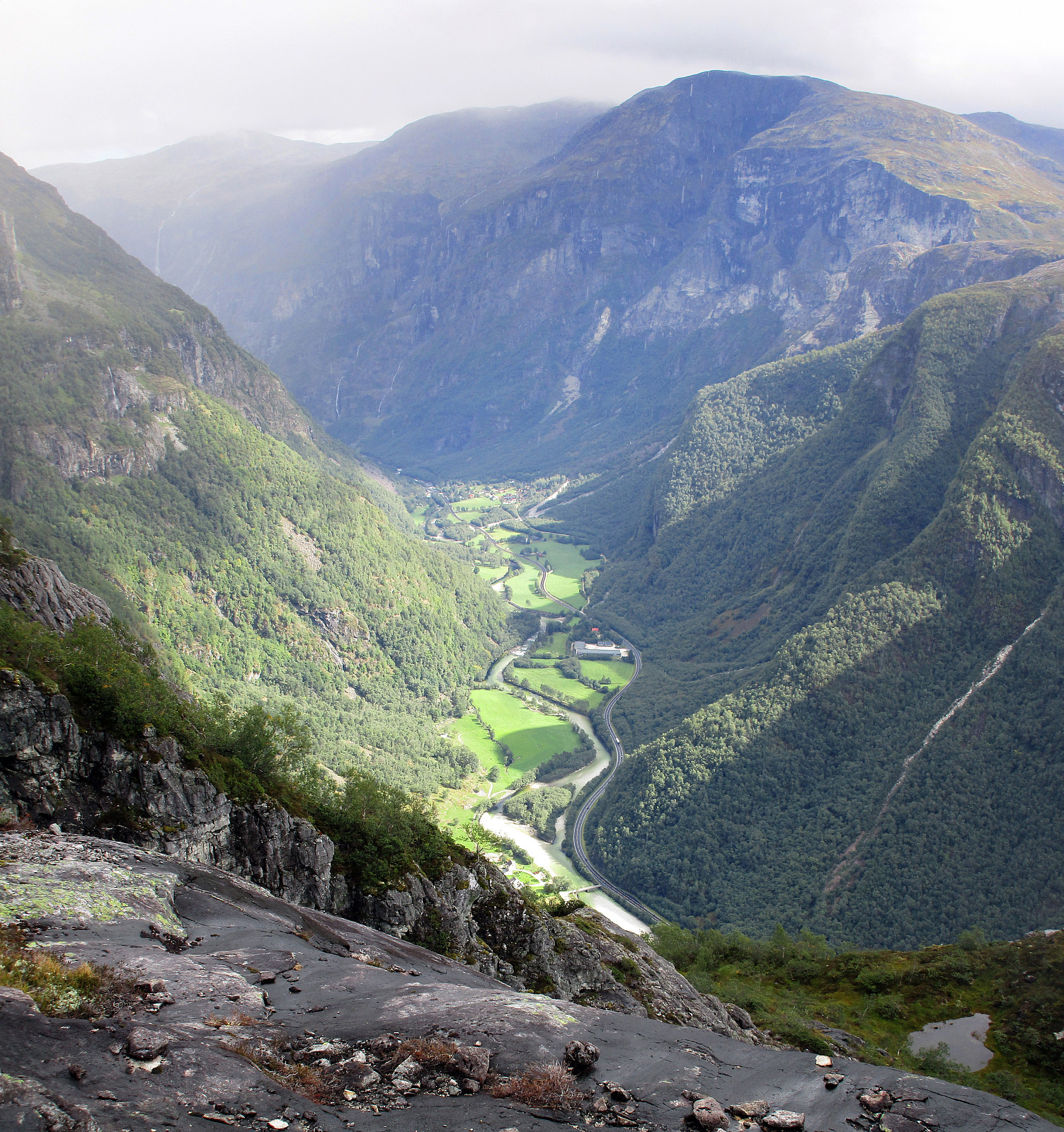 We took road E16 into direction of Gudvangen first and turned to the left (towards Jordalen) after descending into Nærøydalen below Stalheim. We then drove through the new tunnel (now on the eastern side of the valley) up to Jordalen. After leaving the tunnel, we crossed one bridge immediately, before parking the car just ahead of the next bridge. From there we hiked, first over the bridge to the other side of Jordalselvi (to its eastern side), then southwards along the steep eastern side of the valley (into the direction of Jordalsnuten), following a proper path (note that the trail head is not really easy to see; we needed a bit of searching until we found it). It's interesting, also, that the path leads first (more or less) horizontally (with quite a bit of up and down, though) out >>>
Tverråsen, etc., and Furehaugen, etc.
- Datum:
- 19.08.2018
- Tourcharakter:
- Bergtour
- Tourlänge:
- 4:00h
- Entfernung:
- 11,0km
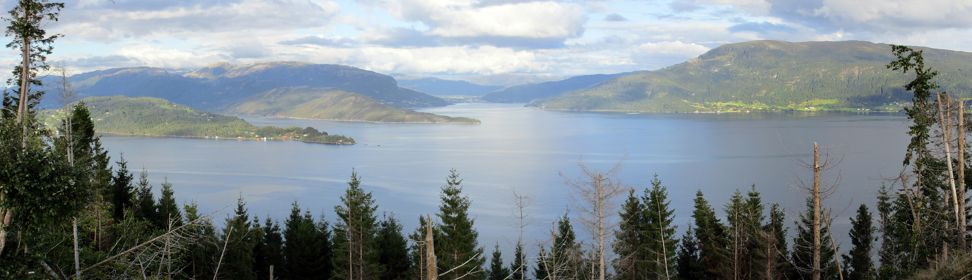 I drove from Bergen to Os in the south and then further into the direction of Hattvika, where a ferry can take you over to Venjaneset (Fusa). Only a few hundred meter before reaching the ferry stop, I turned left and drove up a little road towards Berge. More or less at the first possibility, I parked and started walking (first following the road further up, in northeastern direction). After passing by the houses at Tussaskarva, I found the spot, where the road crosses a little stream, coming down from the right (east). There, it was possible to leave the road and continue on a simple tractor road in northeastern direction (basically following the stream). At about 120mosl, the valley forks into two and I took the left one, continuing in norther direction. This lead me, as expected, to >>>
To Raudlifjellet and back via Hatlelia
- Datum:
- 12.08.2018
- Tourcharakter:
- Bergtour
- Tourlänge:
- 5:00h
- Entfernung:
- 10,0km
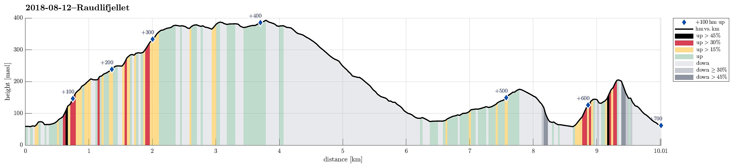 We had the (kind of ambitious) plan to walk a round over Nordhordlandskulten, descending to the south from it (even though it was unclear from the consulted maps, whether this should be reasonably doable, given the also quite steep side of the mountain there). To have the car at the right side of the mountain, we parked along Gåssandvegen near a place called Haukeland. The first task was to find the path, which would lead northover in order to bring us to a place from which it would be reasonable to cross over to the main path up to Nordhordlandskulten (the standard approach is from Tømmernes, a little further north). After a little bit of searching, we quickly found the track which leads northwards into Vetlaleitet (a quite nice little valley, in fact!). We then also found the tractor >>>
Slettegga and Nobbane
- Datum:
- 11.08.2018
- Tourcharakter:
- Bergtour
- Tourlänge:
- 3:00h
- Entfernung:
- 8,6km
 We parked at the Bontveit saddle (where the street crosses over to Hausdalen). From there, we first followed a gravel road that leads northwards. At about 360mosl, we continued along the road, which leads relatively steeply up to Langemyrskaret on the left. Once up there, we continued along the road first, before then following a path, which leads up to Rambjørgvatnet. From there, we started our real ascent to Slettegga, going in northeastern direction. Getting higher, we enjoyed some dramatically looking views into the direction of Arna (the weather was not all sunny). From the top of Slettegga, we first continued along a path, leading into the direction of Austefjellet. Soon after, however, we left the path to cross over to Nobbane, right next to Slettegga and a little lower in altitude. >>>
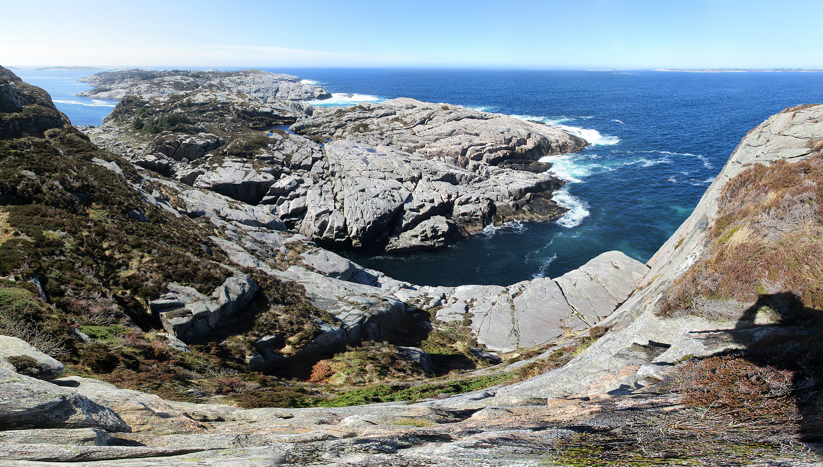
Nice and wild Skogsøyna
- Datum:
- 09.08.2018
- Tourcharakter:
- Wanderung
- Tourlänge:
- 3:30h
- Entfernung:
- 8,1km
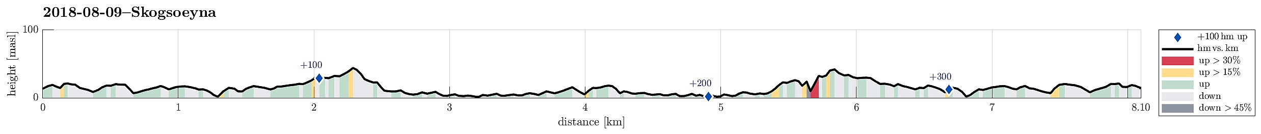 We parked our cars near the bridge between Skogsøyna and Herdlevær, where a board also tells the hikers about the island and the paths that one can take. From there, we followed the main path along the northwestern shore of Skogsøyna, heading towards the spectacular southwestern end of the island. After a bit of hiking, we approached Skogsøytua, i.e., the highest point on this trip (about 45mosl). From there, instead of heading back "as usually", we first explored the lower parts of the cliffs at Skogshola. Note that it is critical that you indeed judge the situation correctly in order to avoid any dangerous and unwanted problems with the sea. Should it happen that a wave takes you off the stones, it is likely possible that you will end up in severe troubles (others have >>>
Up Stoltzekleiven and back via Fløyen
- Datum:
- 06.08.2018
- Tourcharakter:
- Bergtour
- Tourlänge:
- 2:30h
- Entfernung:
- 8,5km
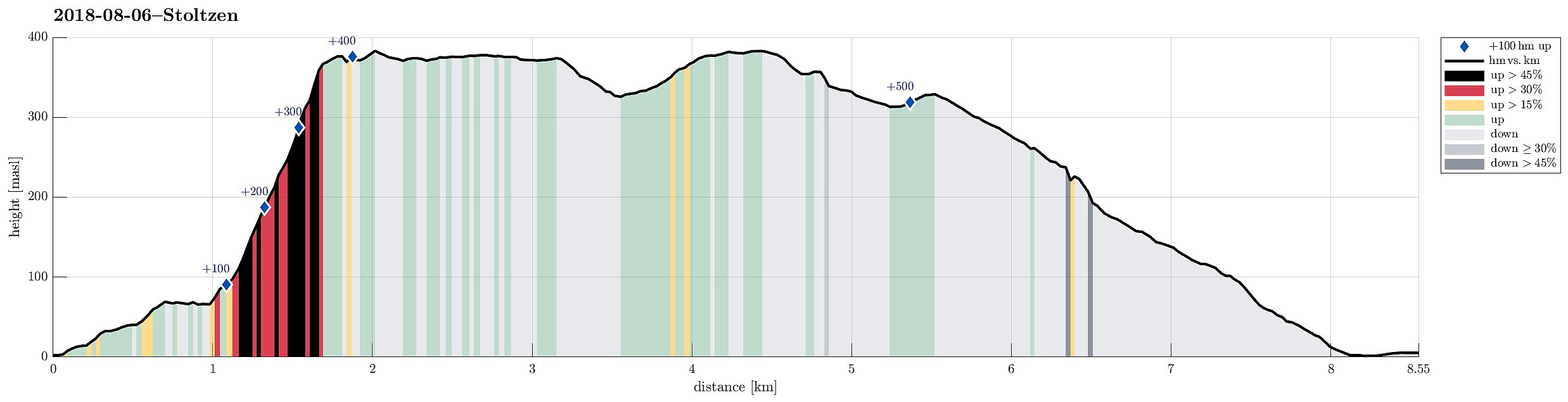 We took the bus to Sandviken and ascended through some (very) small roads up to Fjellveien in order to get to the start of Stoltzekleiven. A little bit of rain helped to cool us down, while ascending to Sandviksfløyen. From Sandvikspilen it is always a nice view over Bergen! When continuing from there, we could not resist a short dive into Storevatnet, before proceeding towards Fløyen. We took Tippetue (via Vindeggen) down to Bergen, before catching a bus in Olav Kyrres gate. Always a challenge to "run" up Stoltzekleiven as fast as possible! :-)
Selected photos are available as Google photo album .
See also the related FB-page Hiking around Bergen, Norway .
The hiking portal UT.no describes a similar hike .
We took the bus to Sandviken and ascended through some (very) small roads up to Fjellveien in order to get to the start of Stoltzekleiven. A little bit of rain helped to cool us down, while ascending to Sandviksfløyen. From Sandvikspilen it is always a nice view over Bergen! When continuing from there, we could not resist a short dive into Storevatnet, before proceeding towards Fløyen. We took Tippetue (via Vindeggen) down to Bergen, before catching a bus in Olav Kyrres gate. Always a challenge to "run" up Stoltzekleiven as fast as possible! :-)
Selected photos are available as Google photo album .
See also the related FB-page Hiking around Bergen, Norway .
The hiking portal UT.no describes a similar hike .
After-flight hike to Knappen
- Datum:
- 05.08.2018
- Tourcharakter:
- Bergtour
- Tourlänge:
- 2:00h
- Entfernung:
- 4,8km
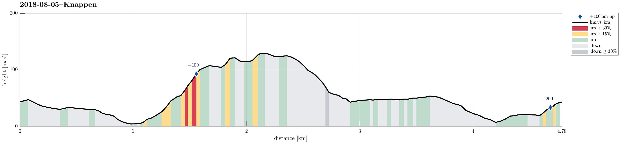 To stretch our legs a little bit, we decided to make a quick hike over Knappen, ignoring the fact that it rained (more or less). We started from Varden, went first towards Gjeddevatnet, before we went down to Bjørgeveien and from there further to Sandeidbrotet. From there, we continued via a nice path, leading first up to Eldtona, before from there connecting to Såta, the highest point in Knappen (not very high, after all). After enjoying a bit of a view of Grimstadfjorden, we descended to the southern end of Knappetjørna. Before returning back to Varden via Vassteigen, we dived for a short swim into Knappetjørna. All in all, even though the weather was suboptimal, this was a refreshing excursion at the end of the day.
See also the related FB-page Hiking around Bergen, Norway .
Petter Bjørstad has a useful page about Knappen .
To stretch our legs a little bit, we decided to make a quick hike over Knappen, ignoring the fact that it rained (more or less). We started from Varden, went first towards Gjeddevatnet, before we went down to Bjørgeveien and from there further to Sandeidbrotet. From there, we continued via a nice path, leading first up to Eldtona, before from there connecting to Såta, the highest point in Knappen (not very high, after all). After enjoying a bit of a view of Grimstadfjorden, we descended to the southern end of Knappetjørna. Before returning back to Varden via Vassteigen, we dived for a short swim into Knappetjørna. All in all, even though the weather was suboptimal, this was a refreshing excursion at the end of the day.
See also the related FB-page Hiking around Bergen, Norway .
Petter Bjørstad has a useful page about Knappen .
Exploring Turøyna
- Datum:
- 11.05.2018
- Tourcharakter:
- Bergtour
- Tourlänge:
- 3:00h
- Entfernung:
- 3,3km
 It was time to get out to Turøyna and explore the rather wild nature there! We started from the street to the small settlement on Turøyna and headed towards the large cairn, Turøyvarden, on the largest top of the island. From there, we continued northwards (and without any path) to reach Svartanova via Tuskeluren. From there, to get further northwest to Laksneset, we had to find a way to cross over a rather deep trough. Starting relatively low on Svartanova and searching for a proper place "on half height", walking in southwestern direction, proved to be the right approach and after only a few steps, we were able to cross over. Then it was straight forward to get to Laksneset and enjoy some nice views from there. Continuing our hike around the island, we then followed the >>>
Short hike on Storskora
- Datum:
- 11.05.2018
- Tourcharakter:
- Wanderung
- Tourlänge:
- 0:30h
- Entfernung:
- 2,0km
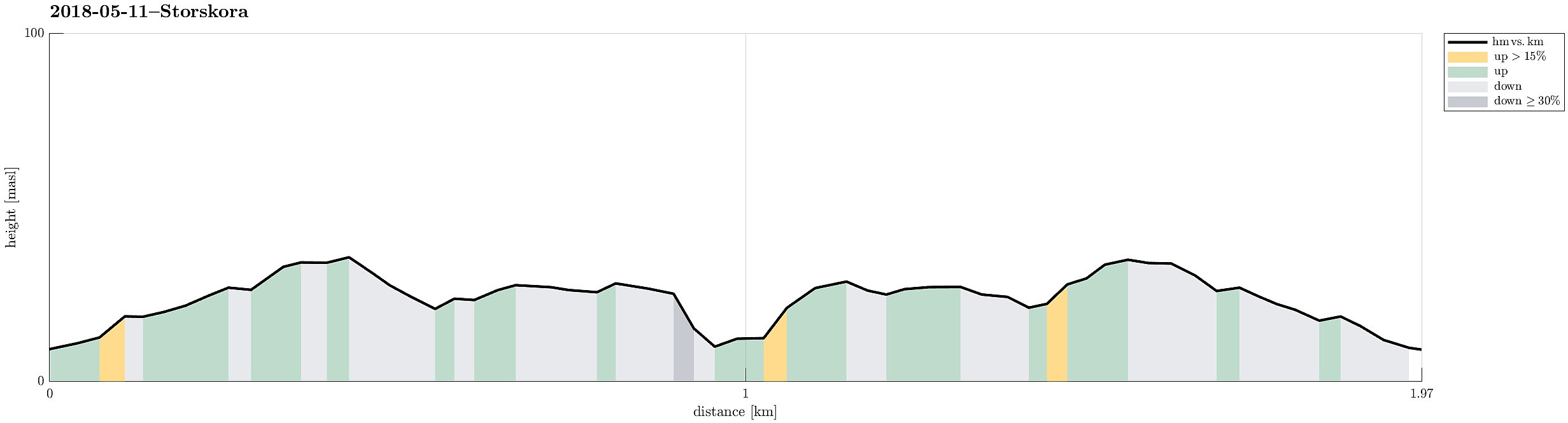 After our hike on Turøyna , we continued with a short hike on Storskora, visiting a little light house at the northwestern end of this little island. Following a nicely marked path from the street, it was straight-forward to reach our target. From there, we basically took the same path back, then.
Selected photos are available as Google photo album .
See also the related FB-page Hiking around Bergen, Norway .
After our hike on Turøyna , we continued with a short hike on Storskora, visiting a little light house at the northwestern end of this little island. Following a nicely marked path from the street, it was straight-forward to reach our target. From there, we basically took the same path back, then.
Selected photos are available as Google photo album .
See also the related FB-page Hiking around Bergen, Norway .
Short hike along the northwestern side of Sælenvatnet
- Datum:
- 06.05.2018
- Tourcharakter:
- Wanderung
- Tourlänge:
- 0:30h
- Entfernung:
- 2,3km
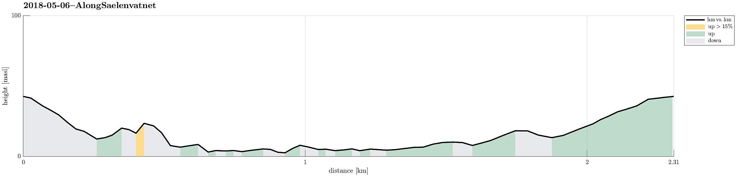 Starting from Varden, this was "only" a short hike along the northwestern side of Sælenvatnet.
Selected photos are available as Google photo album .
See also the related FB-page Hiking around Bergen, Norway .
Starting from Varden, this was "only" a short hike along the northwestern side of Sælenvatnet.
Selected photos are available as Google photo album .
See also the related FB-page Hiking around Bergen, Norway .
