Archiv - Nach Datum
Archiv - Nach Aktivität
-
Andere Tour (1)
- Kayaking (1)
-
Andere Wintertour (4)
- Schneeschuhtour (4)
-
Fahrradtour (137)
- Fahrradtour Straße (9)
- Fahrradtour gemischt (51)
-
Fußtour (740)
- Bergtour (363)
- Jogging (18)
- Spaziergang (89)
- Wanderung (270)
-
Skitour (4)
- Tourenskilauf (4)
Archiv - Nach Geografie
Peakbookfreunde


Gesammelte Listen
-
Bergen ≥ 50m pf. og ≥ 100 m.o.h.
(87/89)
 97%
97% -
Most dominating tops of the Bergen peninsula
(68/75)
90%
-
Utvalgte topper og turmål i Bergen
(316/350)
90%
-
Alle topper i Bergen
(357/398)
89%
-
Opptur Bergen
(100/113)
88%
-
De syv fjell rundt Bergen
(6/7)
85%
-
Sund ≥ 50m pf.
(14/18)
77%
-
Os ≥ 50m pf.
(25/34)
73%
-
Søyler (fastmerker) i Bergen
(68/100)
68%
-
Fjell ≥ 50m pf.
(21/32)
65%

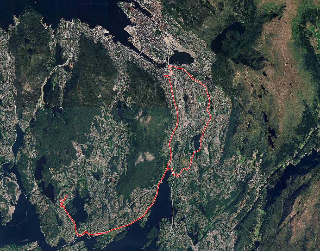
Biking Askøy with Dyrdalsfjellet
- Datum:
- 15.05.2026
- Tourcharakter:
- Fahrradtour gemischt
- Tourlänge:
- 4:00h
- Entfernung:
- 38,2km
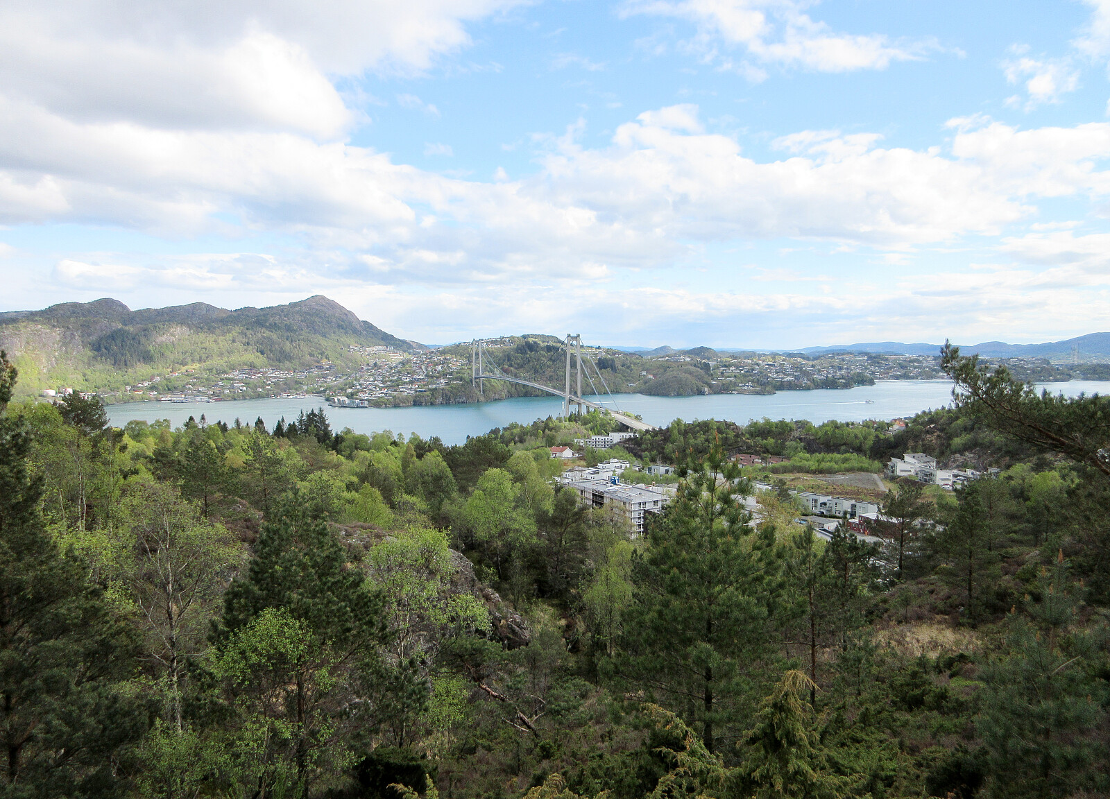 After work, we still wished to get out and thus decided to make a bike-trip to Askøy. After following the main bike-route to Askøy, which follows first Kjøkkelvikveien, north of Loddefjord, before then continuing along Sundby Hvorups vei to connect to the large bridge, we then cycled up Stongafjellsvegen to get up to the south of Dyrdalsfjellet. In fact, it was possible to bike almost all the way up and we "only" had a few height meters left to walk, after leaving our bikes behind on the saddle in the south of Dyrdalsfjellet. After first enjoying the views from Dyrdalsfjellet, we then included also Varden at Øvre Kleppe for some more nice views. Once back to the bikes, we decided that we could make a round via Erdalen before heading back. We therefore continued to bike in >>>
To Alvøen and back
- Datum:
- 14.05.2026
- Tourcharakter:
- Fahrradtour gemischt
- Tourlänge:
- 1:30h
- Entfernung:
- 26,2km
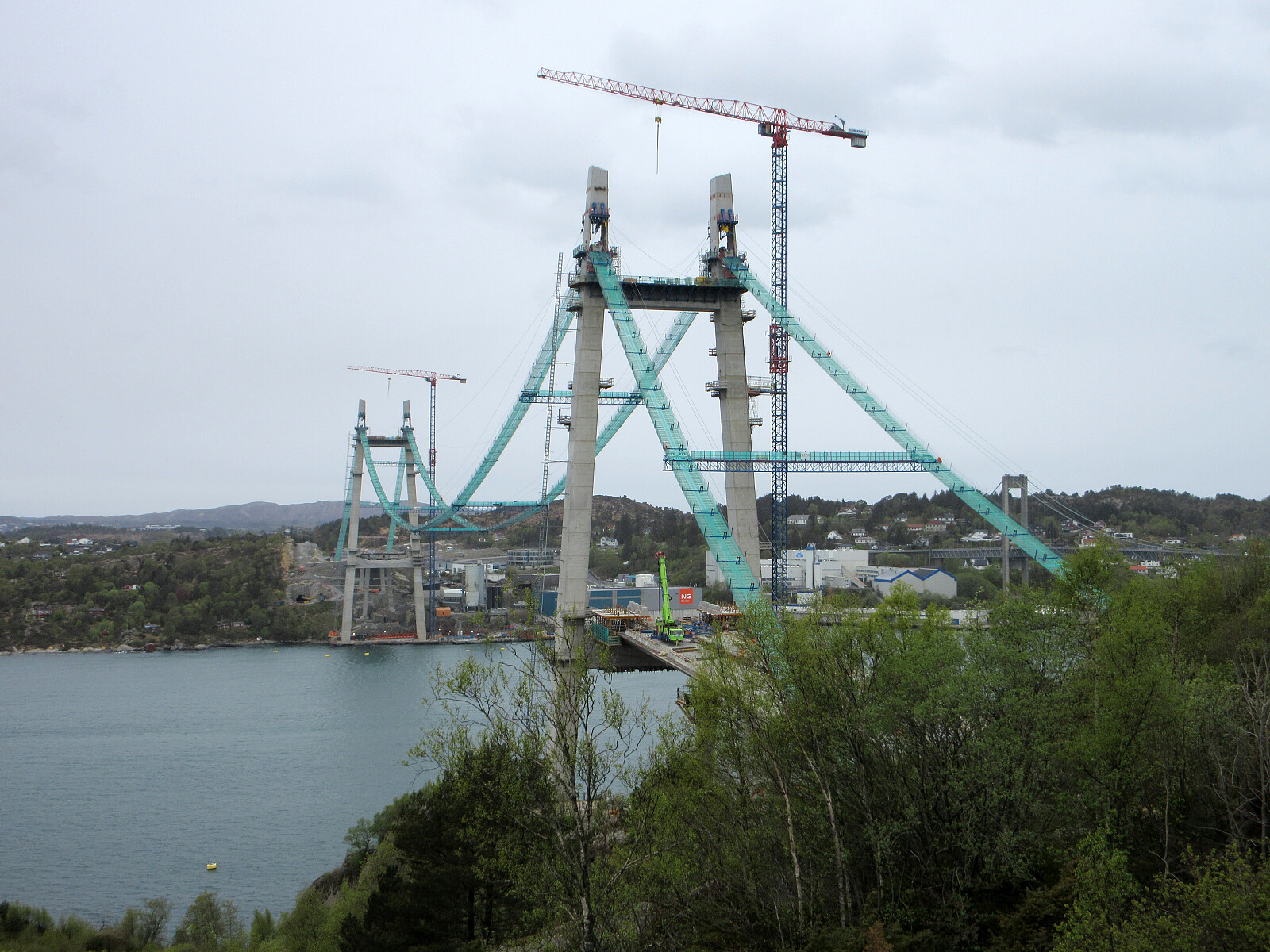 We thought that it would be interesting to have another look at the progress of the construction of the new bridge to Sotra. We thus took our bikes and headed into the direction of Alvøen. At Hetlevikstraumen, we used the small bridge to get over to the western side of Mathopsvågen. At Mathopen, we then took a turn to the right in order to connect to Småvatnet a bit further north. Biking along Småvatnet, we then connected to Hakonshellaveien. From there, we then descended to the old main building of Alvøen. On the other side of Alvøen, the continuation was then along Pålaveien and Ramsvikveien further northwards. At Janaveien, the new bridge came into view, first, and from Janahaugen one could enjoy a nice close-up view. Also from the other side, at Drotningsvikveien, looking >>>
To Åsane via Bergen and back
- Datum:
- 07.05.2026
- Tourcharakter:
- Fahrradtour Straße
- Tourlänge:
- 2:30h
- Entfernung:
- 56,1km
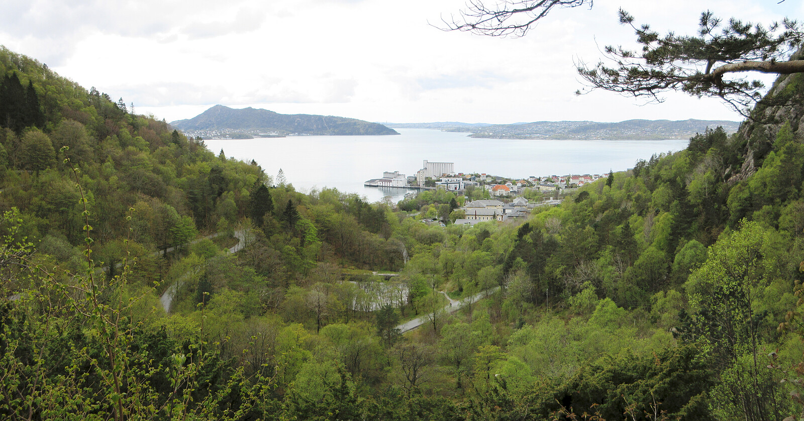 I had something to do in Åsane and thus decided to extend my bike to trip to Bergen by a detour via Åsane. On my way back, I included a traverse via Munkebotn (instead of cycling around Eidsvågsneset again) and Fjellveien.
See also the related FB-page Hiking around Bergen, Norway .
On web page prominent-mountains.no , there's a [xxx|useful page about Xxx].
Similarly, on web page WestCoastPeaks.com , there's also a [xxx|useful page about Xxx].
I had something to do in Åsane and thus decided to extend my bike to trip to Bergen by a detour via Åsane. On my way back, I included a traverse via Munkebotn (instead of cycling around Eidsvågsneset again) and Fjellveien.
See also the related FB-page Hiking around Bergen, Norway .
On web page prominent-mountains.no , there's a [xxx|useful page about Xxx].
Similarly, on web page WestCoastPeaks.com , there's also a [xxx|useful page about Xxx].
Bike-hiking Fanafjellet
- Datum:
- 03.05.2026
- Tourcharakter:
- Fahrradtour gemischt
- Tourlänge:
- 5:00h
- Entfernung:
- 42,3km
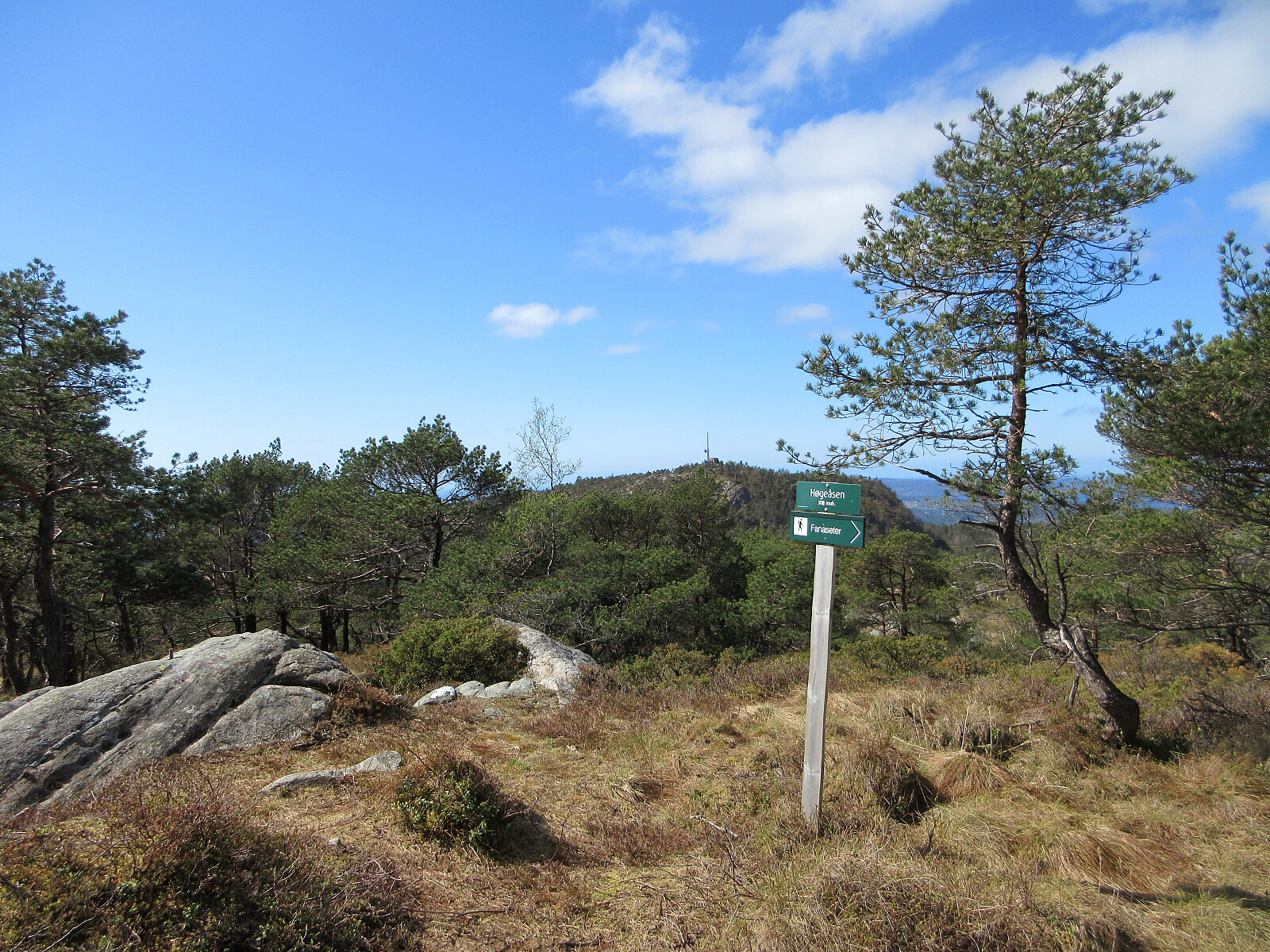 We decided to combine biking and hiking, heading to Fanafjellet with our bikes. Leaving our bikes behind at Fanasæter, we then hiked the one round on Fanafjellet, which includes Høgeåsen and Lyseskarfjellet (Linken), returning via Ramberget to Fanasæter. On our way back, we then included a short detour via Fanahammeren, before then cycling around Hordnesskogen. From Grimseidvegen, we then crossed through Skageskogen to get to Øvre Birkeland. From there, it was then along Ytrebygdsvegen back. Nice to comine biking and hiking on such a nice day! :-)
Selected photos are available as Google photo album .
See also the related FB-page Hiking around Bergen, Norway .
On web page WestCoastPeaks.com , there's a useful page about Lyseskarfjellet and Høgeåsen .
We decided to combine biking and hiking, heading to Fanafjellet with our bikes. Leaving our bikes behind at Fanasæter, we then hiked the one round on Fanafjellet, which includes Høgeåsen and Lyseskarfjellet (Linken), returning via Ramberget to Fanasæter. On our way back, we then included a short detour via Fanahammeren, before then cycling around Hordnesskogen. From Grimseidvegen, we then crossed through Skageskogen to get to Øvre Birkeland. From there, it was then along Ytrebygdsvegen back. Nice to comine biking and hiking on such a nice day! :-)
Selected photos are available as Google photo album .
See also the related FB-page Hiking around Bergen, Norway .
On web page WestCoastPeaks.com , there's a useful page about Lyseskarfjellet and Høgeåsen .
To Åsane, and back
- Datum:
- 19.04.2026
- Tourcharakter:
- Fahrradtour Straße
- Tourlänge:
- 3:00h
- Entfernung:
- 55,1km
 The main plan for the day was to visit the textile factor museum in Salhus. To get there, we had planned to take a historic bus from Åsane terminal. To get to Åsane, we used our bikes. Nothing special to report about the bike-trip, though (we biked the same route there and back, using the main bike route around Eidsvågsneset).
See also the related FB-page Hiking around Bergen, Norway .
The main plan for the day was to visit the textile factor museum in Salhus. To get there, we had planned to take a historic bus from Åsane terminal. To get to Åsane, we used our bikes. Nothing special to report about the bike-trip, though (we biked the same route there and back, using the main bike route around Eidsvågsneset).
See also the related FB-page Hiking around Bergen, Norway .
Short round around Varden
- Datum:
- 18.04.2026
- Tourcharakter:
- Spaziergang
- Tourlänge:
- 0:45h
- Entfernung:
- 2,1km
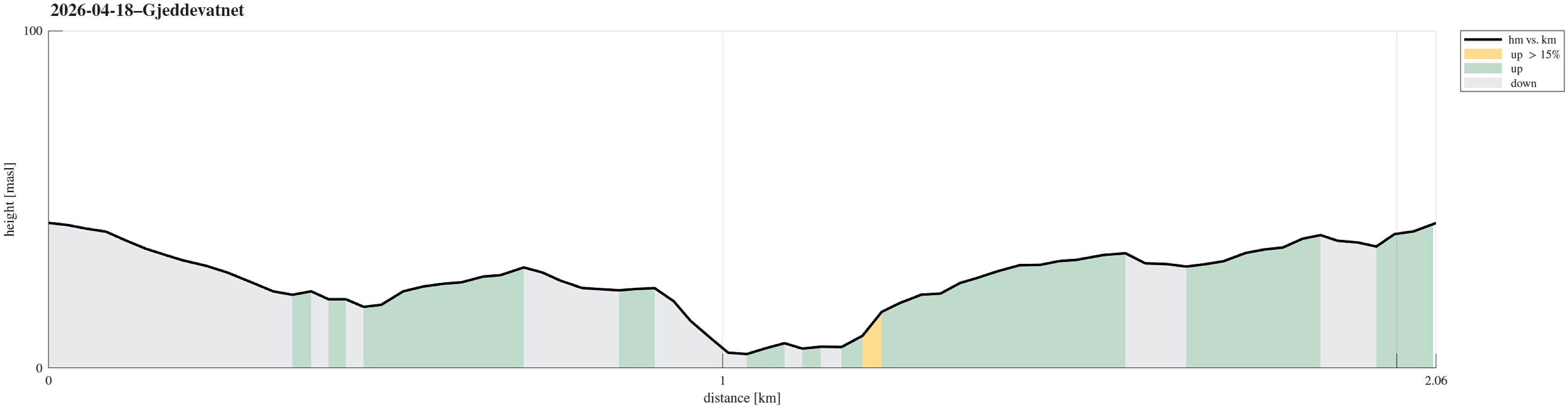 Just an evening walk around Varden, including a short visit to Gjeddevatnet.
See also the related FB-page Hiking around Bergen, Norway .
Just an evening walk around Varden, including a short visit to Gjeddevatnet.
See also the related FB-page Hiking around Bergen, Norway .
To Arboretet in Milde, and back
- Datum:
- 12.04.2026
- Tourcharakter:
- Fahrradtour gemischt
- Tourlänge:
- 2:00h
- Entfernung:
- 29,1km
 Just a nice bike-ride to/from Arboretet in Milde. On our way back, we decided to take a slightly different route, following Grimseidvegen, towards the northeast, before finding a connection towards Skage through Skageskogen passing by Kolhushaugen. From Skage, we then continued along Håvardstunvatnet and Skranevatnet. Via Søvik, we eventually made it back onto usual tracks.
See also the related FB-page Hiking around Bergen, Norway .
Just a nice bike-ride to/from Arboretet in Milde. On our way back, we decided to take a slightly different route, following Grimseidvegen, towards the northeast, before finding a connection towards Skage through Skageskogen passing by Kolhushaugen. From Skage, we then continued along Håvardstunvatnet and Skranevatnet. Via Søvik, we eventually made it back onto usual tracks.
See also the related FB-page Hiking around Bergen, Norway .
Tysnessåta from Myrdal
- Datum:
- 11.04.2026
- Tourcharakter:
- Wanderung
- Tourlänge:
- 3:45h
- Entfernung:
- 6,9km
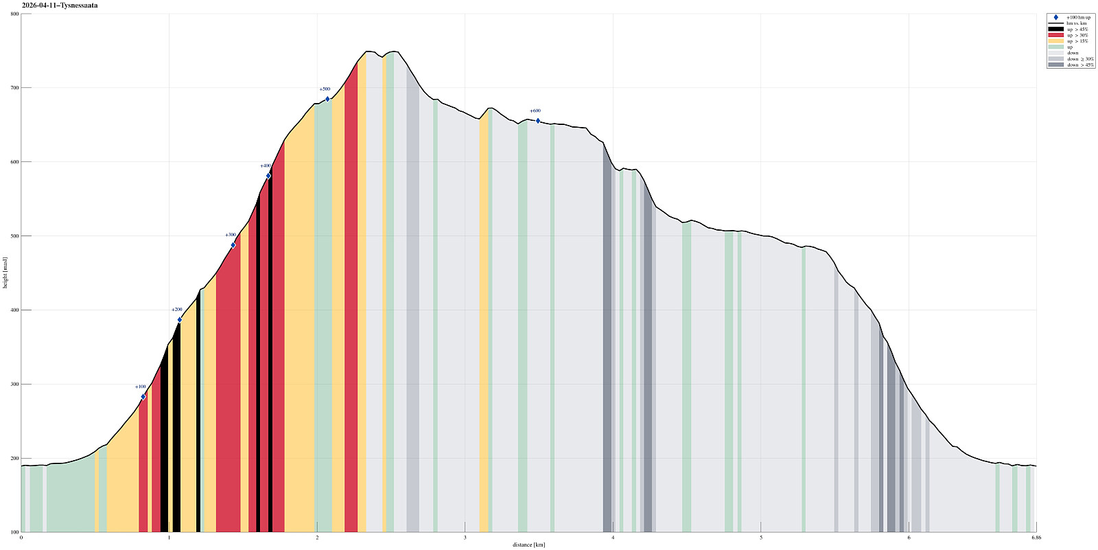 The idea was to make a nice hike on a nice day, which would (1) bring us up to enjoy some nice views and (2) avoid significant amounts of snow, if possible (well, well). We took the ferry from Halhjem to Våge and then drove around and up to Myrdal (already at about 195masl). After parking near Storåkerhølen, a bit north of Myrdal, we started our hike first on a tractor road across Myrdal, before getting into the real hike from the "second" parking place south of Myrdal. From there, one can now (since 2024) find a "Sherpasti" with numerous impressive rock steps that are laid down for large stretches of the ascent along Steinelva. This way, one can "simply" step up these stone steps and reach the heights of Tysnessåta quickly (one still needs to make about >>>
Exploring Skiparvika and Skjoldabukta
- Datum:
- 06.04.2026
- Tourcharakter:
- Fahrradtour gemischt
- Tourlänge:
- 4:00h
- Entfernung:
- 32,6km
 Just a nice bike trip around Nordåsvatnet (with a bit of exploration near Skjoldabukta). In the southwest of Nordåsvatnet, we followed a "side-line", which brought us to Skranevatnet and Håvardstunvatnet, before passing also by Skeievatnet (then in the south of Nordåsvatnet). After thereafter cycling around Apeltunvatnet, we arrived at Skjold, where we left the bikes behind for a short walk to Skiparvika and Skjoldabukta. On our way back, we traversed Nybøvegen before reconnecting with more usual paths. Just near Hopsbukta, we also included a short detour along Nordahl Griegs vei, before then following the standard route back.
See also the related FB-page Hiking around Bergen, Norway .
Just a nice bike trip around Nordåsvatnet (with a bit of exploration near Skjoldabukta). In the southwest of Nordåsvatnet, we followed a "side-line", which brought us to Skranevatnet and Håvardstunvatnet, before passing also by Skeievatnet (then in the south of Nordåsvatnet). After thereafter cycling around Apeltunvatnet, we arrived at Skjold, where we left the bikes behind for a short walk to Skiparvika and Skjoldabukta. On our way back, we traversed Nybøvegen before reconnecting with more usual paths. Just near Hopsbukta, we also included a short detour along Nordahl Griegs vei, before then following the standard route back.
See also the related FB-page Hiking around Bergen, Norway .
To Bergen and back
- Datum:
- 04.04.2026
- Tourcharakter:
- Fahrradtour gemischt
- Tourlänge:
- 1:30h
- Entfernung:
- 25,0km
 Just a nice evening bike-trip to Bergen (and back).
See also the related FB-page Hiking around Bergen, Norway .
Just a nice evening bike-trip to Bergen (and back).
See also the related FB-page Hiking around Bergen, Norway .
