Archiv - Nach Datum
Archiv - Nach Aktivität
-
Andere Tour (1)
- Kayaking (1)
-
Andere Wintertour (4)
- Schneeschuhtour (4)
-
Fahrradtour (137)
- Fahrradtour Straße (9)
- Fahrradtour gemischt (51)
-
Fußtour (740)
- Bergtour (363)
- Jogging (18)
- Spaziergang (89)
- Wanderung (270)
-
Skitour (4)
- Tourenskilauf (4)
Archiv - Nach Geografie
Peakbookfreunde


Gesammelte Listen
-
Bergen ≥ 50m pf. og ≥ 100 m.o.h.
(87/89)
 97%
97% -
Most dominating tops of the Bergen peninsula
(68/75)
90%
-
Utvalgte topper og turmål i Bergen
(316/350)
90%
-
Alle topper i Bergen
(357/398)
89%
-
Opptur Bergen
(100/113)
88%
-
De syv fjell rundt Bergen
(6/7)
85%
-
Sund ≥ 50m pf.
(14/18)
77%
-
Os ≥ 50m pf.
(25/34)
73%
-
Søyler (fastmerker) i Bergen
(68/100)
68%
-
Fjell ≥ 50m pf.
(21/32)
65%

Kongsberg north of Ulvik
- Datum:
- 04.08.2024
- Tourcharakter:
- Wanderung
- Tourlänge:
- 4:00h
- Entfernung:
- 8,1km
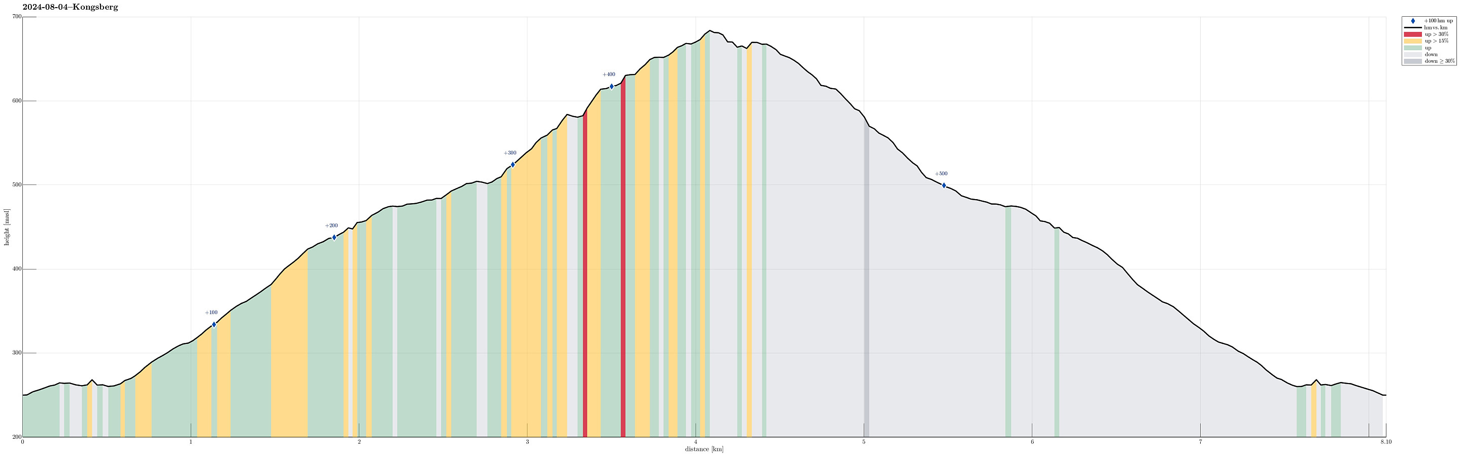 With relatively low-hanging clouds, we aimed at a simple hike that would remain beneath the clouds, but still offer some nice views, hopefully. After some consideration, we thought that hiking up to Kongsberg near Ulvik could be a good solution. We took the road up from Ulvik to Aurdal and parked right next to the road right after passing over Verafossen. From there, we then followed a forest road that lead initially into Seljestidalen, before then winding up towards Klyvhals on the southeastern side of this valley. South of Røyneskor, this forest road leads then westwards (to Vestrheimskleppe). There, one eventually gets to see over the treetops further below and down to Ulvikafjorden. To continue further upwards to Kongsberg it is then mostly to just follow the forest road further. >>>
Kristinuten
- Datum:
- 16.05.2016
- Tourcharakter:
- Bergtour
- Tourlänge:
- 4:00h
- Entfernung:
- 8,3km
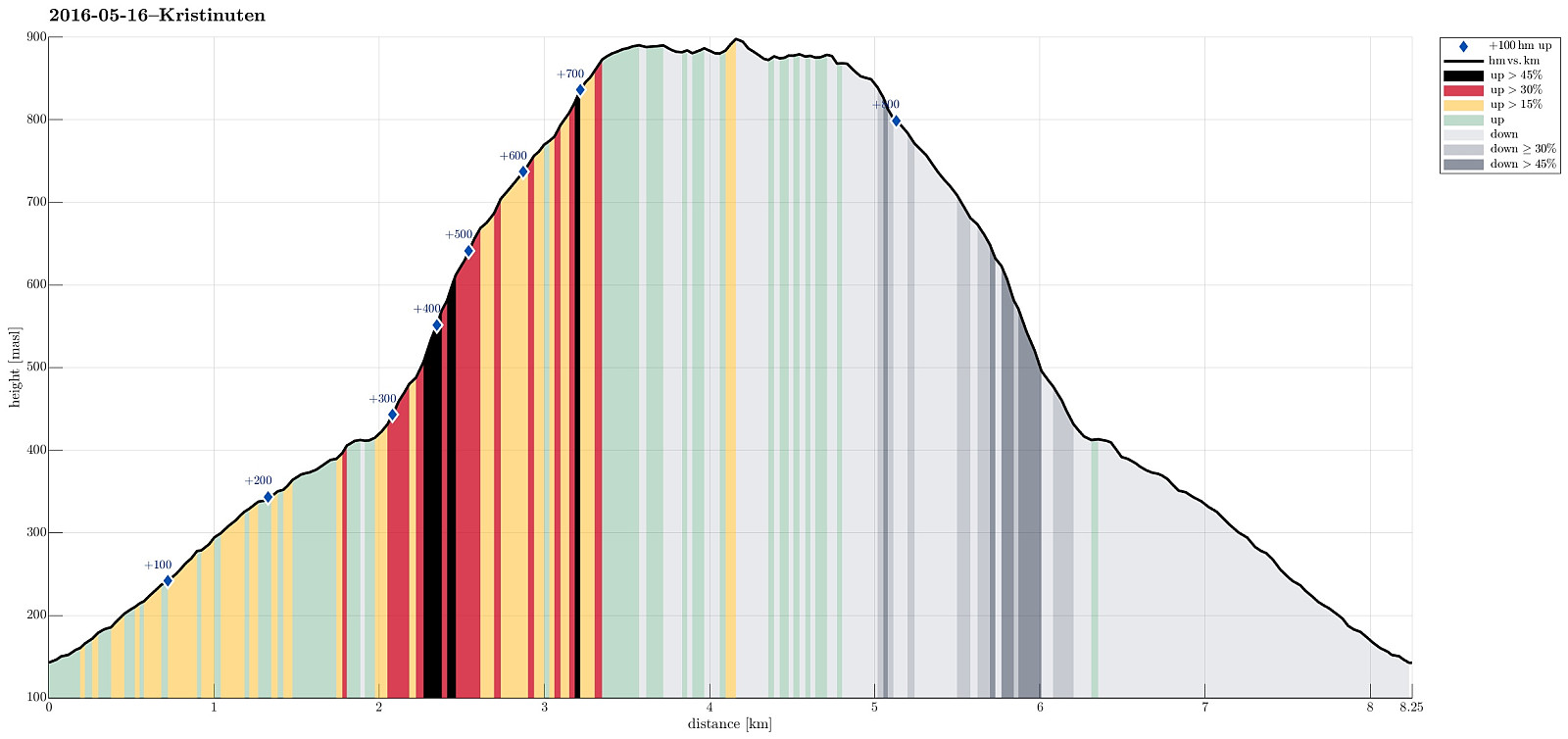 We started from the road between Ulvik and Osa, driving basically to the top of the saddle (between Ulvikafjorden and Osafjorden). There, we continued a little bit further on a side road the passes by Øydve. When getting close to the forrest, we parked and started hiking. The first 300 height meters are convenient on a forrest road that winds back and forth towards Liastølane. Then, one needs to pay attention. A sign ("Kleppe", I think) tells to leave the forrest road and continue along a minor path. This trail is really hard to find---the best tip is to look out for small stones that mark the path. One first ascends further through the forrest before reaching the tree line very soon. From there, it is basically straight up to the top of Kristinuten. It is recommended to >>>
Birje
- Datum:
- 19.09.2015
- Tourcharakter:
- Spaziergang
- Tourlänge:
- 3:00h
- Entfernung:
- 12,9km
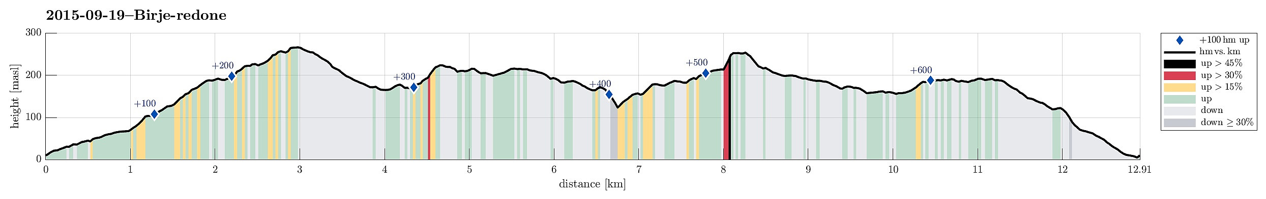 Starting from a place near Øydvenstod, I first followed Osavegen up to the saddle towards Ulvik. There, I turned left, westwards, and ascended the few meters up to Håheim. From there, I followed the marked path -- in southwestern direction -- in order to get up to Åsen. It's not so clear, where the top actually is -- Åsen is well-covered with a forest and there are a number of ups and downs. I found my way to the antenna that is also seen from Ulvik and from there, via a simple path, down to Vattatveit. From there, I first followed the forest road, but when it turned left -- in eastwards directions -- I left it (to the right) and crossed Trånemyrhaugen (basically without any path). I crossed another forest road and continued (without path), this time up Vetlefurehaugen. On the other >>>
