Archiv - Nach Datum
Archiv - Nach Aktivität
-
Andere Tour (1)
- Kayaking (1)
-
Andere Wintertour (4)
- Schneeschuhtour (4)
-
Fahrradtour (137)
- Fahrradtour Straße (9)
- Fahrradtour gemischt (51)
-
Fußtour (740)
- Bergtour (363)
- Jogging (18)
- Spaziergang (89)
- Wanderung (270)
-
Skitour (4)
- Tourenskilauf (4)
Archiv - Nach Geografie
Peakbookfreunde


Gesammelte Listen
-
Bergen ≥ 50m pf. og ≥ 100 m.o.h.
(87/89)
 97%
97% -
Most dominating tops of the Bergen peninsula
(68/75)
90%
-
Utvalgte topper og turmål i Bergen
(316/350)
90%
-
Alle topper i Bergen
(357/398)
89%
-
Opptur Bergen
(100/113)
88%
-
De syv fjell rundt Bergen
(6/7)
85%
-
Sund ≥ 50m pf.
(14/18)
77%
-
Os ≥ 50m pf.
(25/34)
73%
-
Søyler (fastmerker) i Bergen
(68/100)
68%
-
Fjell ≥ 50m pf.
(21/32)
65%

Knappen (off trail)
- Datum:
- 01.01.2021
- Tourcharakter:
- Bergtour
- Tourlänge:
- 1:30h
- Entfernung:
- 4,0km
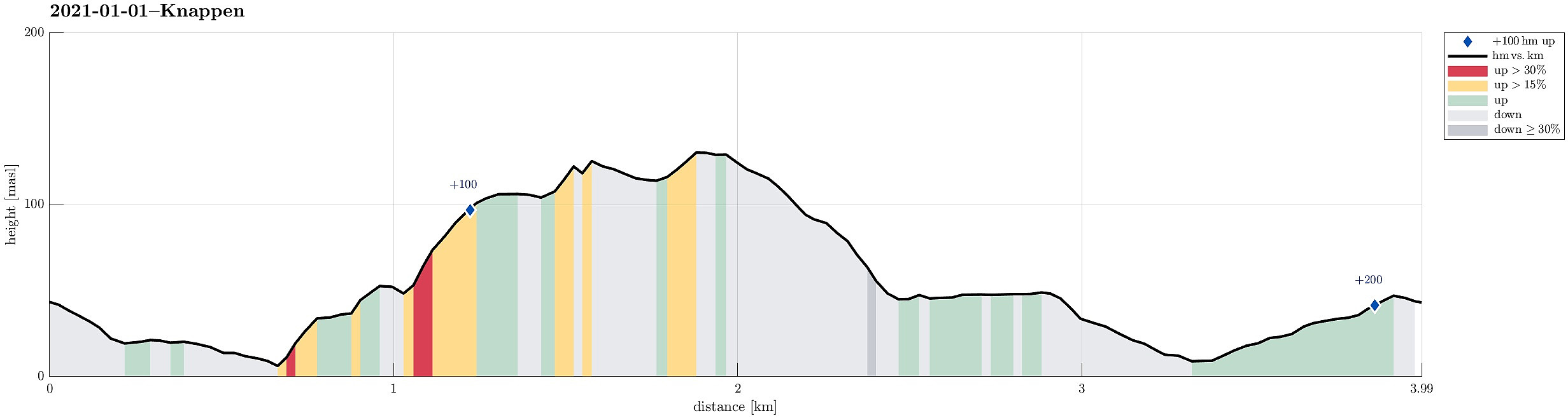 A good way to start a new year, is to do (at least) a small hike in the neighborhood! :-) We started from Varden, walking towards Knappen on the other side of Bjørgeveien. Going Marineveien down, we decided to explore "the other side" right away (without first walking along Bjørgeveien). Even though we did that without any trail, it still was reasonably easy and within a short while we arrived at the top of Sandeidbrotet (this "short-cut" is OK for an exploration, but will not become our new standard route to Knappen, though). From Sandeidbrotet we continued up another short hillside to Vassteigen, where we (for a moment) connected with one of the trails to Knappen. Instead of following this trail, however, we again diverted into "the wild", ascending more >>>
Kanadaskogen with Hesjaholten
- Datum:
- 25.12.2020
- Tourcharakter:
- Bergtour
- Tourlänge:
- 3:00h
- Entfernung:
- 8,8km
 With a somewhat average weather forecast on tap, we decided to "just" do a simple walk/hike in Kanadaskogen. Starting from Varden, we first headed for the eastside of Gjeddevatnet, near the fotball fields and Framohallen. After rounding Gjerdsvika, we ascended a little (in northwards direction) in order to get over to (the eastside of) Bjørndalsvatnet, which we then walked along until its northern most end. Continuing in northwards direction, we then walked up to Svartatjørna. On the other, northern side of it, while walking along Storamyra then, we enjoyed to look up to Tobrik, high up over the east of Storamyra. Walking out this little valley, we ended up at the gravel road that leads up to the dam of Tennebekktjørna. About halv way up this road, we then decided to split >>>
Eikhaugen
- Datum:
- 07.11.2020
- Tourcharakter:
- Bergtour
- Tourlänge:
- 3:30h
- Entfernung:
- 7,5km
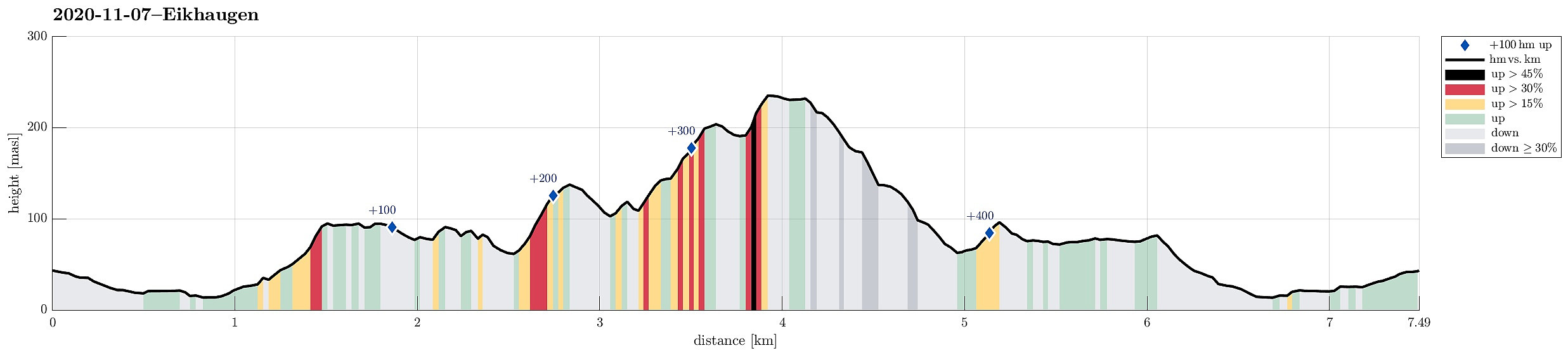 A quite wet day invited to engage with some local exploration. After some short planning, Eikhaugen was identified as the overall goal, this afternoon. Starting from Varden, we headed north, first. At Askeladdveien, we decided to ascend relatively steeply to some minor heights west of Peer Gyntsvei. Crossing over this ridge south--north, we connected to the east-facing hillside in the west of Spelhaugen. At the northern end of Spelhaugen, where the Kindergarden and the parking place for Tennebekk-hikers is, we crossed over to the other, northeastern side of Spelhaugen, ascending relatively steeply up to the (also minor) heights north of Barliveien (Lurane). Rounding the southern end of Eikelifjellet on its southeastern side (northwest of Løvås), we entered a nice valley with a little >>>
Rundehaugen from Fjæreide
- Datum:
- 27.09.2020
- Tourcharakter:
- Bergtour
- Tourlänge:
- 4:30h
- Entfernung:
- 9,7km
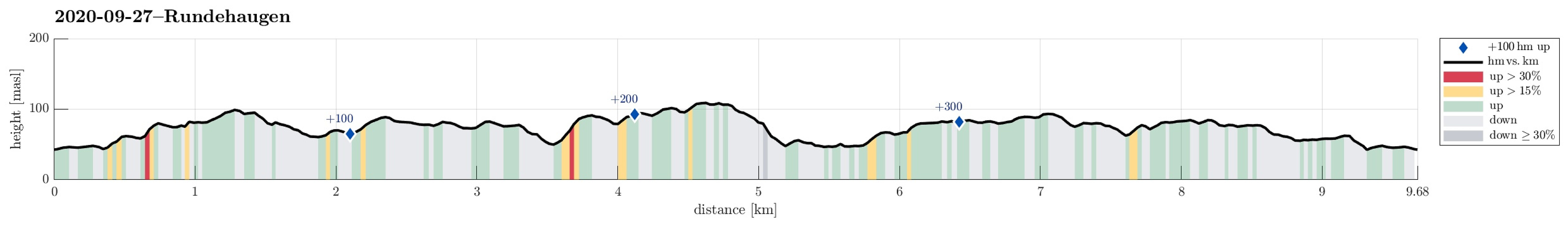 Since we expected the afternoon to be substantially cloudy, we decided to make a hike in the lowlands rather than up on some tops (and in the clouds). Since we had not yet explored this region in detail, we chose to start at Fjæreide (in the west of Knappskog on Sotra) and then aim for Rundehaugen (in the east of Skålvik). After driving along road 555 westwards to Sotra and then northwards (road 561), one comes to Knappskog. There, one can turn left (westwards, again) and follow a narrow road to Fjæreide, where there's ample space for parking next to the road (they may have had, or still have, plans to broaden this road, leaving quite a bit of not yet used space besides the road). At the southern-most point (in Fjæreide) the road crosses over a small valley in a large turn to the right. >>>
Hovdane from Brattholo
- Datum:
- 08.08.2020
- Tourcharakter:
- Bergtour
- Tourlänge:
- 4:00h
- Entfernung:
- 6,4km
 With a somewhat unclear weather forecast, we aimed at something gentle, not too far up. Driving along E16 (into the direction of Voss), we left the main road a little southwest of Vinje, contiuning for bit into the direction of Hommedalen. Driving up Holbygdvegen to about 250mosl, we found a suitable place near Brattholo to park right next to the road. From there, we started walking along a minor road that winds up towards the eastern flank of Hagahovden. A little over 300mosl then, we left the road (basically where it ends) and continued along a trail that continues further upwards. At about 335mosl, we briefly explored a flag post with some view, before soon returning to the trail and following further upwards. At about 500mosl we then arrived at a nice shelter at Hovdane, enjoying >>>
Mor Si Grav (and Bergshaugen)
- Datum:
- 05.08.2020
- Tourcharakter:
- Bergtour
- Tourlänge:
- 1:30h
- Entfernung:
- 4,9km
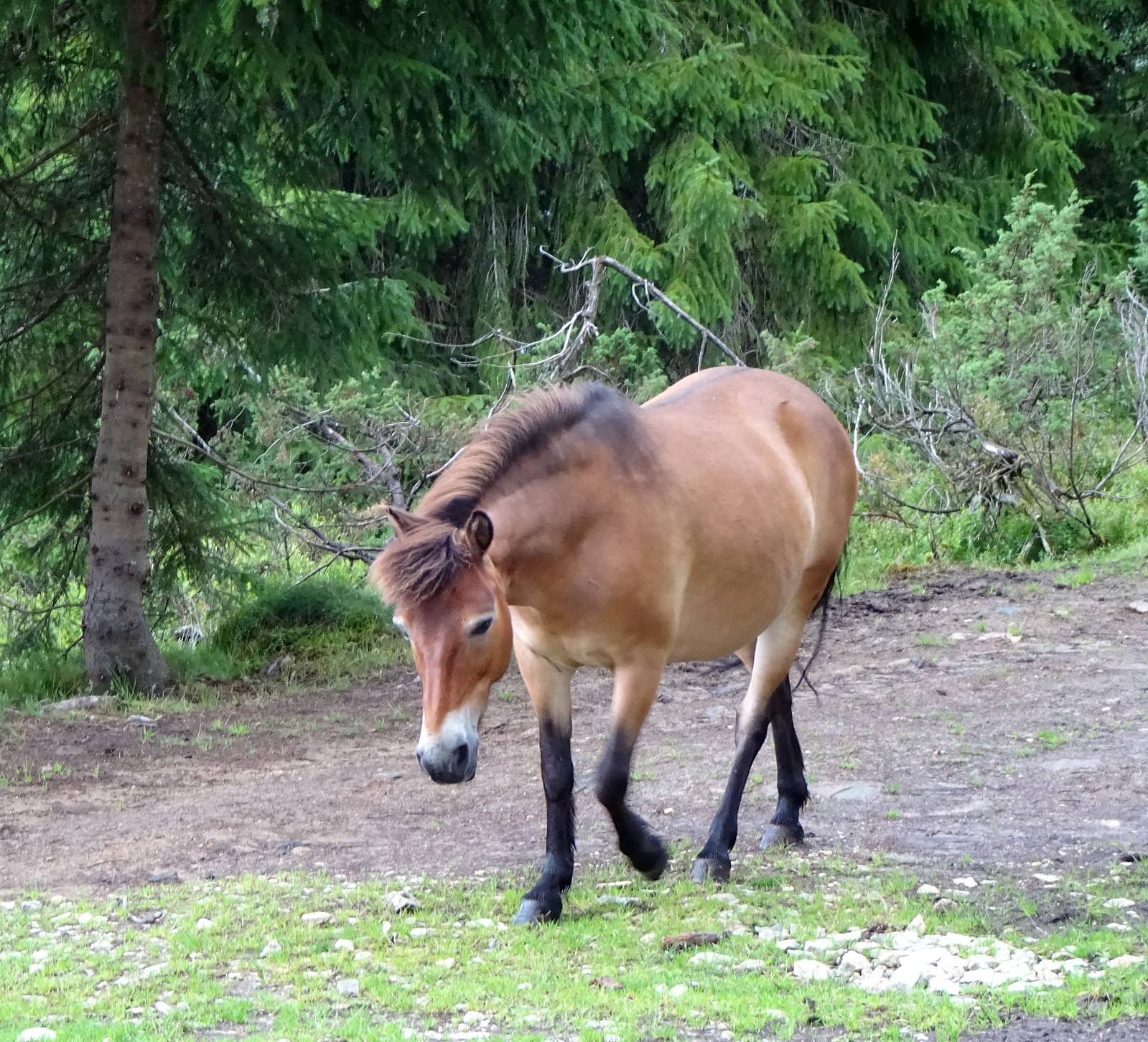
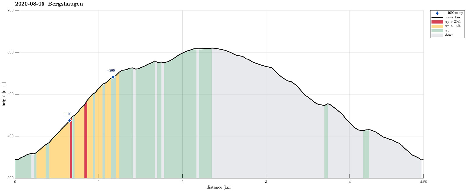 Again and again we had passed by (without stopping) before, so this time, on a rainy day, we decided to stop and take look at "Mor Si Grav" in Oppheim. We parked near the church and walked the few meters up to the old graveyard, where only "Mor Si Grav" (the mother's grave) remains. It's the place where the mother of Per Sivle is buried and an info plate not far from the grave explains some of the (quite moving!) history around it. After taking our time there, we then appended a little round around Bergshaugen, walking first up the hill and then over (at about 550mosl) to Uresåsen. From there, we then followed a gravel road (behind Bergshaugen) to Kvernhusholene. From there, we started our descent, first on the right (northern) side of Gryteelvi. At about 475mosl, >>>
Kongsfjellet via Kongskleivo
- Datum:
- 23.07.2020
- Tourcharakter:
- Bergtour
- Tourlänge:
- 1:30h
- Entfernung:
- 3,8km
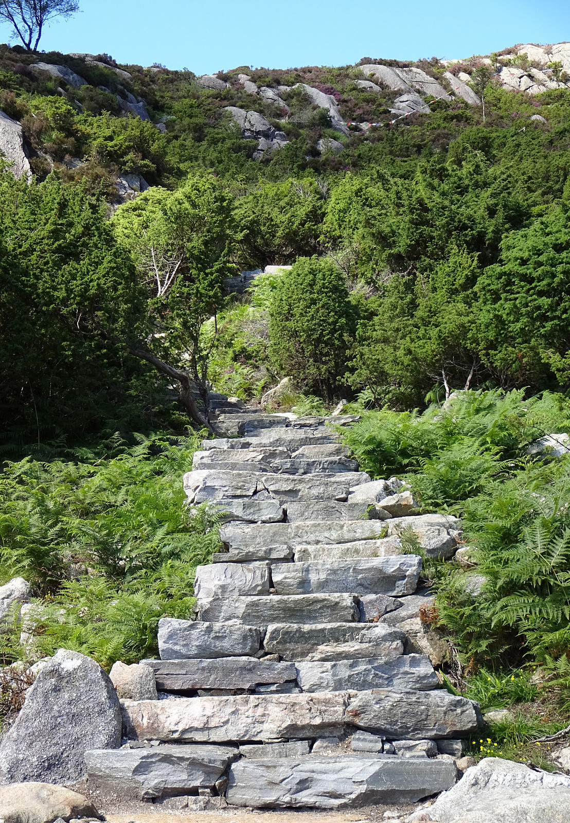 Before returning from Austevoll, we decided to include Kongsfjellet near Bekkjarvik. Passing by Bekkarvik church, we headed toward the starting point of Kongskleivo, i.e., the newly layed stone path up to Kongsfjellet. After first rounding Taushaugen in its east and south, we started with stepping up the big stone steps, ascending to the "top" of Taushaugen before continuing to Kongsfjellet. At Kongsfjellet, we enjoyed some nice views in all directions (mostly across Bekkjarvik and southwards). We then walked a bit across the ridge of Kongsfjellet before hurrying down the stone steps, again, in order to secure a relaxed drive back to the ferry in Hufthammar. All in all, Kongskleivo is, yes, impressive due to the big stones, while then, also, kind of boring. The views from Kongsfjellet, >>>
Vinnesvatnet and Veten
- Datum:
- 22.07.2020
- Tourcharakter:
- Bergtour
- Tourlänge:
- 2:00h
- Entfernung:
- 5,5km
 We took the ferry from Krokeide to Hufthammar and continued southwards from there, following the road into the direction of Husavik (road 546). After passing Husavik, we approached Vinnes, making a spontaneous decision to visit Vinnesvatnet from there. We parked near Hoppensprett kindergarten and started walking along a gravel path that leads very nicely around Vinnesvatnet. On the western side of Vinnesvatnet, we also visited the little island in Vinnesvatnet, walking across a nice little hanging bridge. At the northern end of Vinnesvatnet, where the gravel path deviates a bit from the lake, we started following a trail leading to Veten. After first ascending significantly, we then had a pleasant walk over the heights in the southeast of Veten. Eventually, we came to Veten, enjoying >>>
To Bergen and back
- Datum:
- 18.07.2020
- Tourcharakter:
- Bergtour
- Tourlänge:
- 6:00h
- Entfernung:
- 19,8km
 Walking up Fyllingsdalen and further to Bergen. Enjoying a beer, or two. Walking back. Not much more to write, this time. :-)
See also the related FB-page Hiking around Bergen, Norway .
Walking up Fyllingsdalen and further to Bergen. Enjoying a beer, or two. Walking back. Not much more to write, this time. :-)
See also the related FB-page Hiking around Bergen, Norway .
Kanadaskogen
- Datum:
- 13.06.2020
- Tourcharakter:
- Bergtour
- Tourlänge:
- 3:00h
- Entfernung:
- 8,7km
 With only limited time at our disposal, we "simply" headed for Kanadaskogen. Passing by Gjeddevatnet (coming from Varden), we stepped upwards from Gjerdsvika. This time, we included Allestadhaugen (between Hesjaholten and Bjørndalsvatnet), before descending to the eastern side of Bjørndalsvatjnet. At the very northern end of Bjørndalsvatnet, where one still finds the remains of some former building, we followed the valley upwards (in northern direction), but just 25 height meters, or so. There, we turned left, first following a trail for a short while, before then continuing "straight" upwards to Træshovden through the forest. At Træshovden, we decided the Svartaberget make up a nice next goal (and off we headed there). Due to its very steep western side, Svartaberget >>>
