Archiv - Nach Datum
Archiv - Nach Aktivität
-
Andere Tour (1)
- Kayaking (1)
-
Andere Wintertour (4)
- Schneeschuhtour (4)
-
Fahrradtour (137)
- Fahrradtour Straße (9)
- Fahrradtour gemischt (51)
-
Fußtour (740)
- Bergtour (363)
- Jogging (18)
- Spaziergang (89)
- Wanderung (270)
-
Skitour (4)
- Tourenskilauf (4)
Archiv - Nach Geografie
Peakbookfreunde


Gesammelte Listen
-
Bergen ≥ 50m pf. og ≥ 100 m.o.h.
(87/89)
 97%
97% -
Most dominating tops of the Bergen peninsula
(68/75)
90%
-
Utvalgte topper og turmål i Bergen
(316/350)
90%
-
Alle topper i Bergen
(357/398)
89%
-
Opptur Bergen
(100/113)
88%
-
De syv fjell rundt Bergen
(6/7)
85%
-
Sund ≥ 50m pf.
(14/18)
77%
-
Os ≥ 50m pf.
(25/34)
73%
-
Søyler (fastmerker) i Bergen
(68/100)
68%
-
Fjell ≥ 50m pf.
(21/32)
65%

Lyderhorn
- Datum:
- 24.05.2025
- Tourcharakter:
- Bergtour
- Tourlänge:
- 1:30h
- Entfernung:
- 2,9km
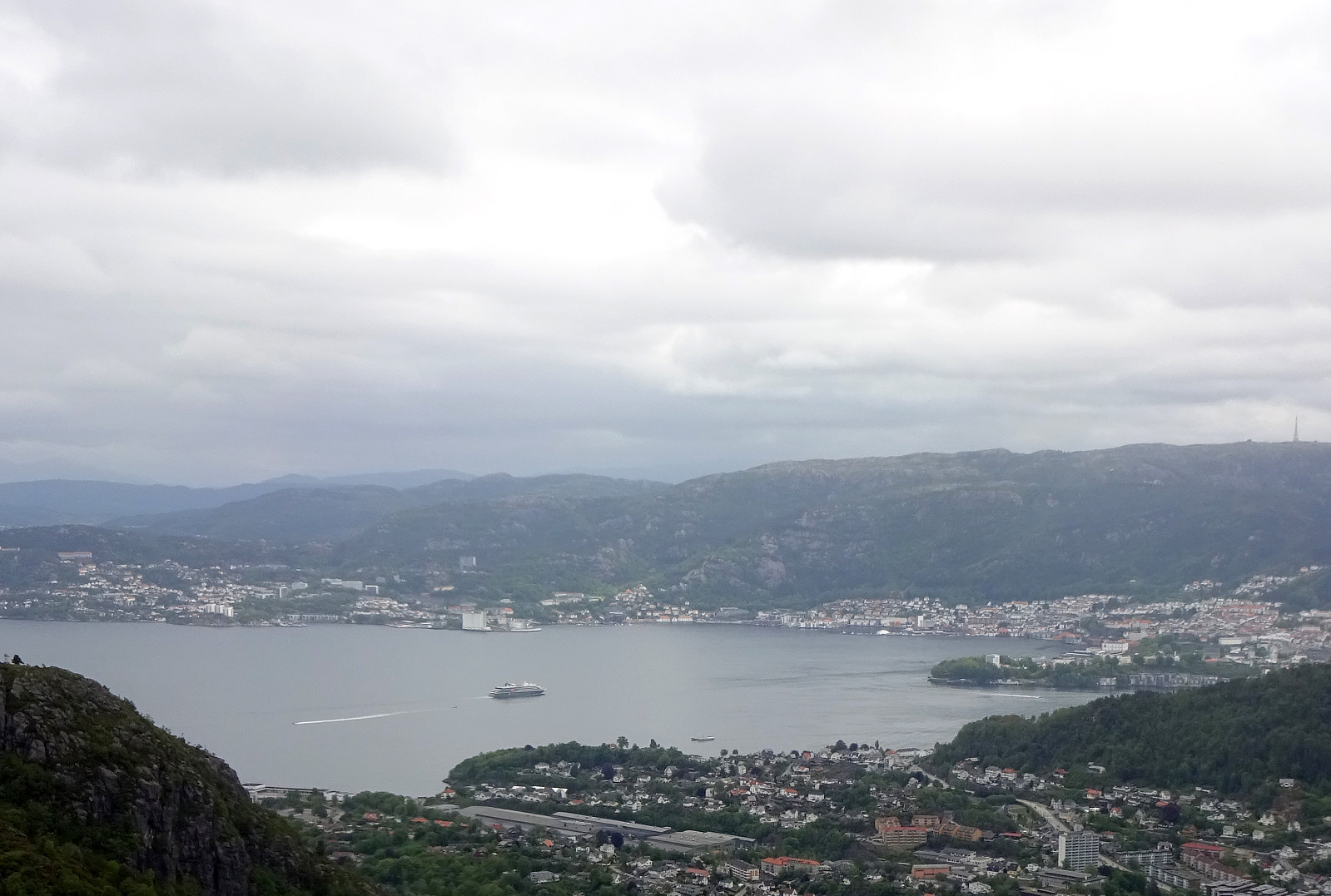 We had something like two hours available and thus aimed at "just" Lyderhorn in the neighborhood. Always nice to hike up and down this little mountain with nonetheless impressive views! :-)
Selected photos are available as Google photo album .
See also the related FB-page Hiking around Bergen, Norway .
Petter Bjørstad has a useful page about Lyderhorn and also web page WestCoastPeaks.com provides useful information about Lyderhorn and Ørnafjellet .
We had something like two hours available and thus aimed at "just" Lyderhorn in the neighborhood. Always nice to hike up and down this little mountain with nonetheless impressive views! :-)
Selected photos are available as Google photo album .
See also the related FB-page Hiking around Bergen, Norway .
Petter Bjørstad has a useful page about Lyderhorn and also web page WestCoastPeaks.com provides useful information about Lyderhorn and Ørnafjellet .
Knappen
- Datum:
- 01.05.2025
- Tourcharakter:
- Bergtour
- Tourlänge:
- 1:00h
- Entfernung:
- 4,4km
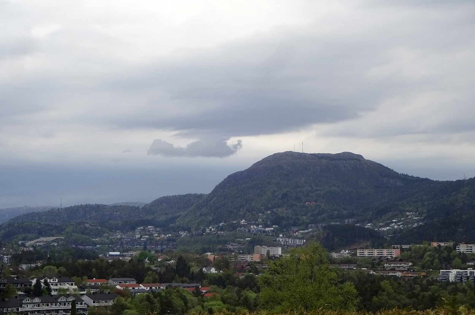 With only little time at our hands (or feet?), we did only a quick excursion to nearby Knappen. Nice! :-)
Selected photos are available as Google photo album .
See also the related FB-page Hiking around Bergen, Norway .
With only little time at our hands (or feet?), we did only a quick excursion to nearby Knappen. Nice! :-)
Selected photos are available as Google photo album .
See also the related FB-page Hiking around Bergen, Norway .
Towards Olsnesnipa from Olsneset
- Datum:
- 20.04.2025
- Tourcharakter:
- Bergtour
- Tourlänge:
- 1:30h
- Entfernung:
- 3,2km
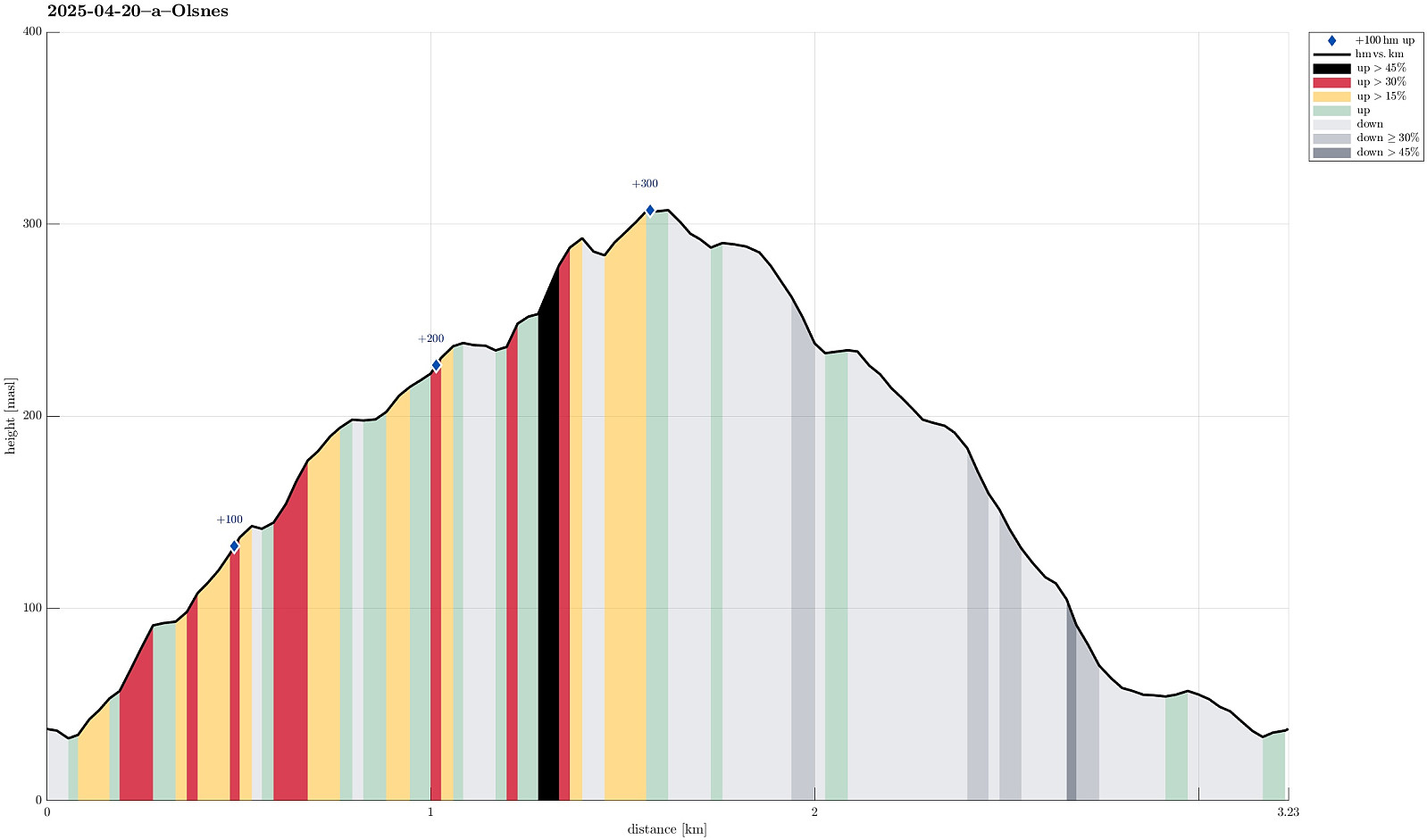 I was in the mood for a quick "before breakfast" stroll and thus headed to explore the heights north of Olsneset on Osterøy. After only a few meters it got confirmed that this would -- at least at large -- be an off-trail excursion. I still gained elevation relatively quickly, searching my way through the vegetation. Several times, I emerged at places with great views (including panoramic views across Sørfjorden -- nice!). Once up to about 240 masl, I got confronted with slightly more challenging terrain -- continuing "whereever" was no longer an option. After having made it down to the foot of an impressive cliff (in my west), I then followed this cliff upwards "right under it". This brought me to a place, where I could easily cross over to the heights, >>>
Hånipa from Reigstad
- Datum:
- 19.04.2025
- Tourcharakter:
- Bergtour
- Tourlänge:
- 2:30h
- Entfernung:
- 5,1km
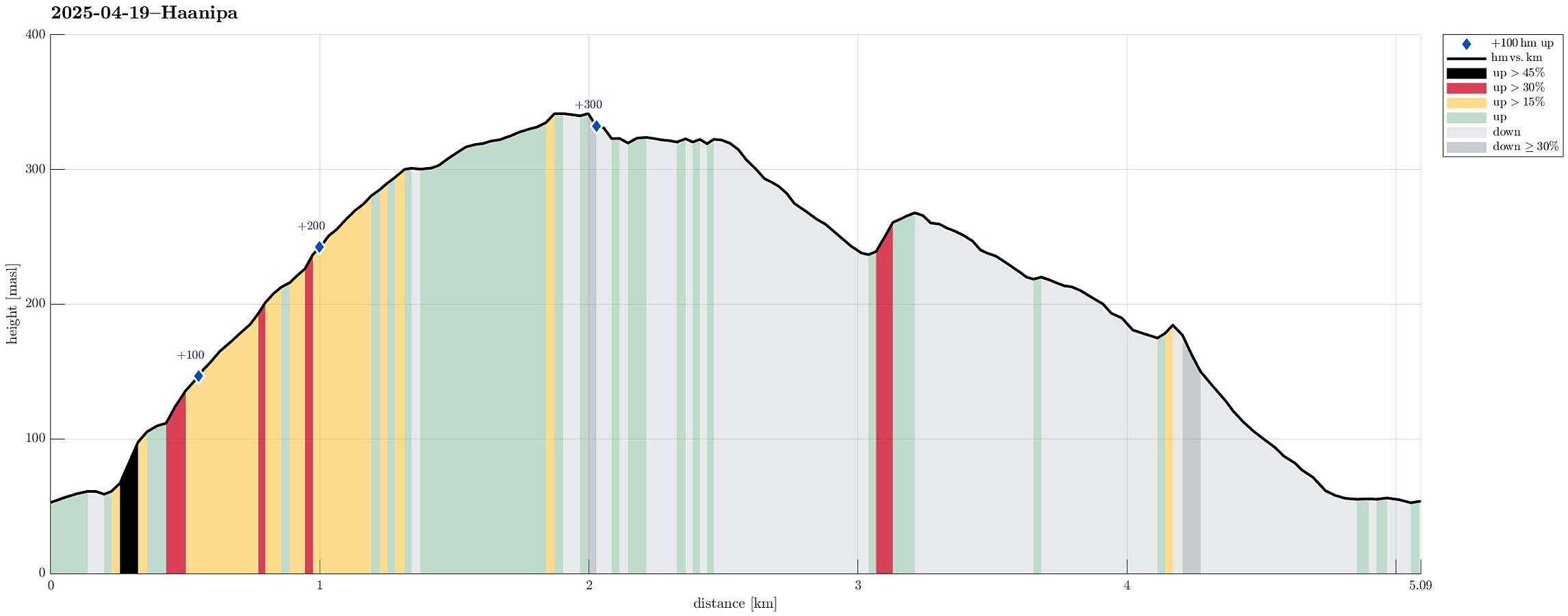 After taking the ferry from Breistein to Valestrand on Osterøy, we drove a bit further southwards and parked near Reigstad. We then followed the main trail across the northern ridge of Reigstadfjellet southwards to get up to Hånipa. We then continued along the high ridge, high above Sørfjorden, a bit more southwards, before turning left and descending into Reigstaddalen, following the main trail. Due to some major forest works, which had impacted the forest road through Reigstaddalen significantly, we then decided to follow Geitryggen instead of staying in the valley for getting back. About half way down, however, we still connected back with the forest road through Reigstaddalen. Somehow, without fully sinking into all the mud, we still made it back down and back to the car! :-) All >>>
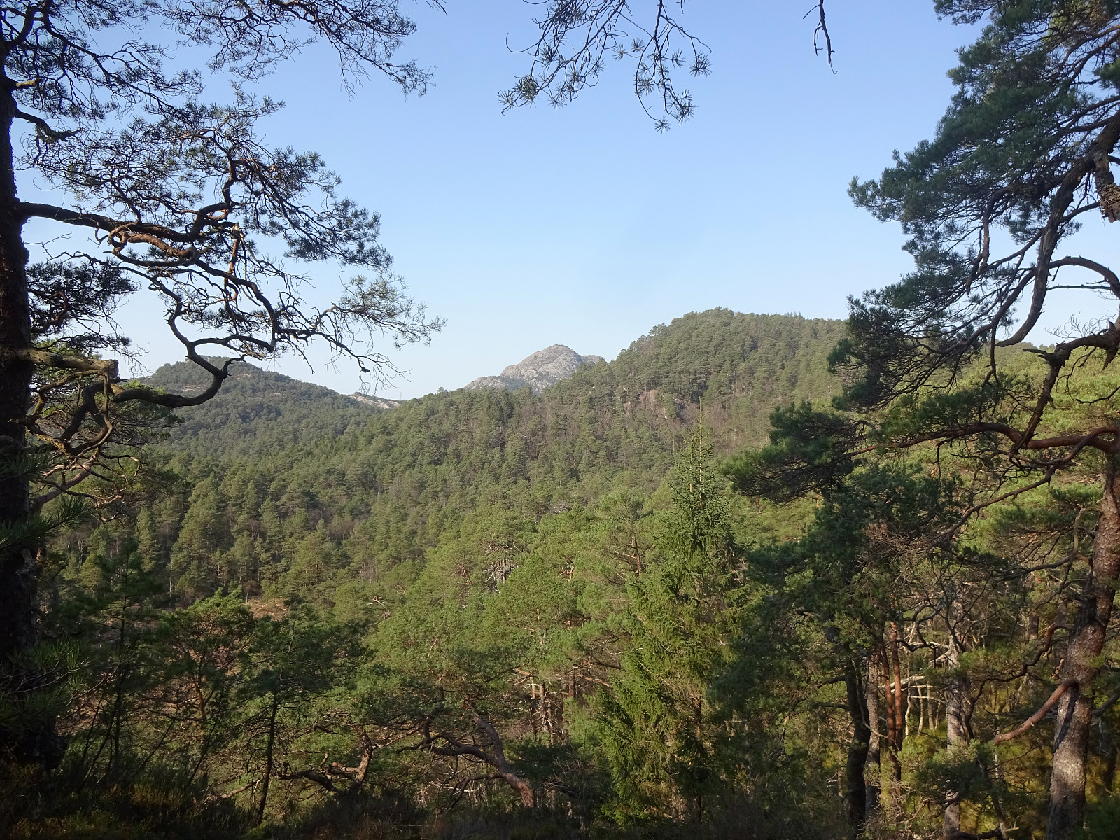
Round around Vinddalsvatnet
- Datum:
- 30.03.2025
- Tourcharakter:
- Bergtour
- Tourlänge:
- 3:00h
- Entfernung:
- 7,7km
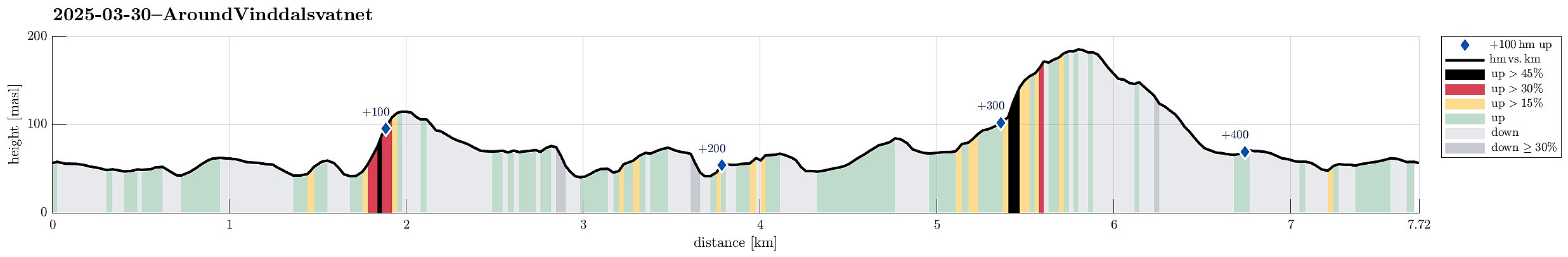 We started in Søfteland, heading for Gamlevegen. Our first goal was to have a look a this old stone bridge (gamle Torve bro), which -- apparently -- once was part of the old Postal route to Stavanger. This bridge seems to be in a pretty bad condition, hold together by some improvised support structure, these days. We then continued further southwards (following, if not mistaken, the former Postal route). After passing by Gåsakilen (on its western side), we left the "main route" to include Galtåsen "on the way". Since we approached it from the North, this ascent was a bit steep at times (but fully doable). From Galtåsen, we then continued in southwestern direction, eventually "ending up" on a nice forest road. But instead of stepping out and onto Byvegen, >>>
Kanadaskogen
- Datum:
- 23.03.2025
- Tourcharakter:
- Bergtour
- Tourlänge:
- 1:30h
- Entfernung:
- 5,5km
 Just a round in Kanadaskogen to use the nice weather for a short walk! :-)
Selected photos are available as Google photo album .
See also the related FB-page Hiking around Bergen, Norway .
Just a round in Kanadaskogen to use the nice weather for a short walk! :-)
Selected photos are available as Google photo album .
See also the related FB-page Hiking around Bergen, Norway .
Satzberg etc.
- Datum:
- 16.03.2025
- Tourcharakter:
- Bergtour
- Tourlänge:
- 2:00h
- Entfernung:
- 9,0km
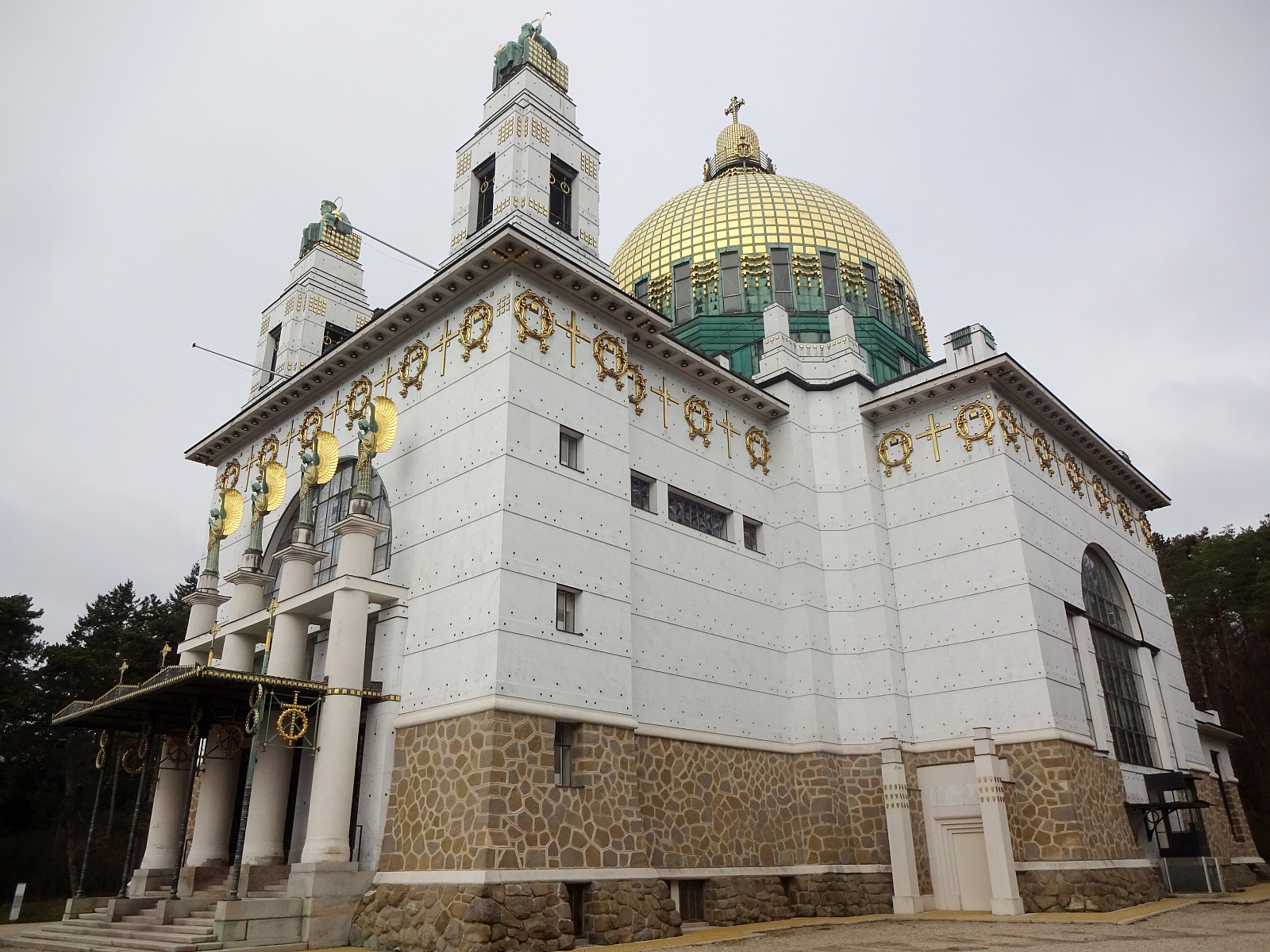 I wished to get some fresh air around my head and thus started a walk without a particular goal in the beginning. At first, I thought that it would be nice to pass by the Otto Wagner church "Am Steinhof" . From there, I continued northwards. But instead of following "the usual tracks" up to Jubiläumswarte , I eventually headed in a more westward direction with the goal to get up to Satzberg. From there, I found a new track (at least for me) down to Hüttelbergstraße. After taking a quick look at the Otto Wagner Villa of Ernst Fuchs -- just from the outside --, I then connected to the cemetary of Hütteldorf, before starting my return leg. Besides the generally nice walk, it also was nice to see the signs of spring (some nice flowers in the forest for example).
Selected photos are available as Google photo album .
See also the related FB-page Hiking around Bergen, Norway .
I wished to get some fresh air around my head and thus started a walk without a particular goal in the beginning. At first, I thought that it would be nice to pass by the Otto Wagner church "Am Steinhof" . From there, I continued northwards. But instead of following "the usual tracks" up to Jubiläumswarte , I eventually headed in a more westward direction with the goal to get up to Satzberg. From there, I found a new track (at least for me) down to Hüttelbergstraße. After taking a quick look at the Otto Wagner Villa of Ernst Fuchs -- just from the outside --, I then connected to the cemetary of Hütteldorf, before starting my return leg. Besides the generally nice walk, it also was nice to see the signs of spring (some nice flowers in the forest for example).
Selected photos are available as Google photo album .
See also the related FB-page Hiking around Bergen, Norway .
Knappen
- Datum:
- 22.02.2025
- Tourcharakter:
- Bergtour
- Tourlänge:
- 1:30h
- Entfernung:
- 5,3km
 Just stretching our legs a little on Knappen...
Selected photos are available as Google photo album .
See also the related FB-page Hiking around Bergen, Norway .
Just stretching our legs a little on Knappen...
Selected photos are available as Google photo album .
See also the related FB-page Hiking around Bergen, Norway .
Stroll through snow and sun around Bjørndalsvatnet
- Datum:
- 01.01.2025
- Tourcharakter:
- Bergtour
- Tourlänge:
- 2:30h
- Entfernung:
- 8,2km
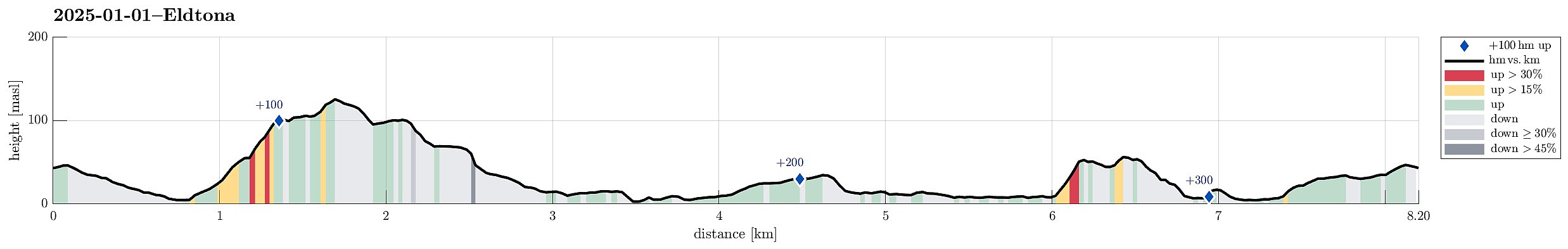 A snowy day with nice weather: a good reason for making a stroll in the neighborhood! We started with Eldtona on Knappefjellet before "turning around" and heading northwards to make a round around Bjørndalsvatnet before returning back to Varden. Not a very long hike, but very nice with the snow and some sun, also! :-)
Selected photos are available as Google photo album .
See also the related FB-page Hiking around Bergen, Norway .
A snowy day with nice weather: a good reason for making a stroll in the neighborhood! We started with Eldtona on Knappefjellet before "turning around" and heading northwards to make a round around Bjørndalsvatnet before returning back to Varden. Not a very long hike, but very nice with the snow and some sun, also! :-)
Selected photos are available as Google photo album .
See also the related FB-page Hiking around Bergen, Norway .
From Lyngholm to Ryvarden
- Datum:
- 16.11.2024
- Tourcharakter:
- Bergtour
- Tourlänge:
- 3:00h
- Entfernung:
- 6,7km
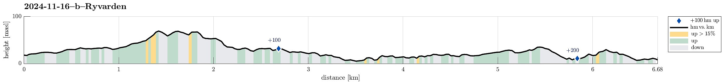 We left one car at the parking lot for Ryvarden in Mølstrevåg, while driving with the other one to Lyngholm a bit further north. There, we found a place, where we could leave the car for 20 NOK. There, we started our hike, following the well-marked North Sea Trail (Nordsjøløypa). Right in the beginning, the weather was a bit rough (strong wind, a bit of rain) -- a bit later, though, it improved and approaching Landsåt, we even got to imagine the sun for some moments! :-) The rather wild weather, however, made walking this trail an interesting experience. Especially the hail showers, which hit us with quite some force due to the strong wind, made sure that we experienced a special kind of presence. :-) Even though the first roughly three kilometers not really are right at the sea, >>>
