Archiv - Nach Datum
Archiv - Nach Aktivität
-
Andere Tour (1)
- Kayaking (1)
-
Andere Wintertour (4)
- Schneeschuhtour (4)
-
Fahrradtour (137)
- Fahrradtour Straße (9)
- Fahrradtour gemischt (51)
-
Fußtour (740)
- Bergtour (363)
- Jogging (18)
- Spaziergang (89)
- Wanderung (270)
-
Skitour (4)
- Tourenskilauf (4)
Archiv - Nach Geografie
Peakbookfreunde


Gesammelte Listen
-
Bergen ≥ 50m pf. og ≥ 100 m.o.h.
(87/89)
 97%
97% -
Most dominating tops of the Bergen peninsula
(68/75)
90%
-
Utvalgte topper og turmål i Bergen
(316/350)
90%
-
Alle topper i Bergen
(357/398)
89%
-
Opptur Bergen
(100/113)
88%
-
De syv fjell rundt Bergen
(6/7)
85%
-
Sund ≥ 50m pf.
(14/18)
77%
-
Os ≥ 50m pf.
(25/34)
73%
-
Søyler (fastmerker) i Bergen
(68/100)
68%
-
Fjell ≥ 50m pf.
(21/32)
65%

Storskaret and Ebbesvikfjellet on Litlesotra
- Datum:
- 28.12.2018
- Tourcharakter:
- Bergtour
- Tourlänge:
- 2:00h
- Entfernung:
- 8,2km
 Since we had plans to buy a few things at a shop at Straume, we decided to use a bit of time for getting some fresh air nearby. While driving to Litlesotra, we repeatedly changed our minds in terms of which road to follow, ending up in Straumsfjellvegen, eventually. Understanding that his road would not let us drive further into the south of Litlesotra, we decided to park at a southern spot along Svartabergje and to walk from there. We used a connection for pedestrians to get down to Arefjordvegen first, before following this street in eastern direction a bit (until a rather large roundabout right next to Storskaret). Looking at the rather steep northern flank of Storskaret, we got a bit unsure concerning the idea to climb up to it (instead of following some more streets). We still gave >>>
Ørnafjellet and Lyderhorn
- Datum:
- 25.12.2018
- Tourcharakter:
- Bergtour
- Tourlänge:
- 2:00h
- Entfernung:
- 6,5km
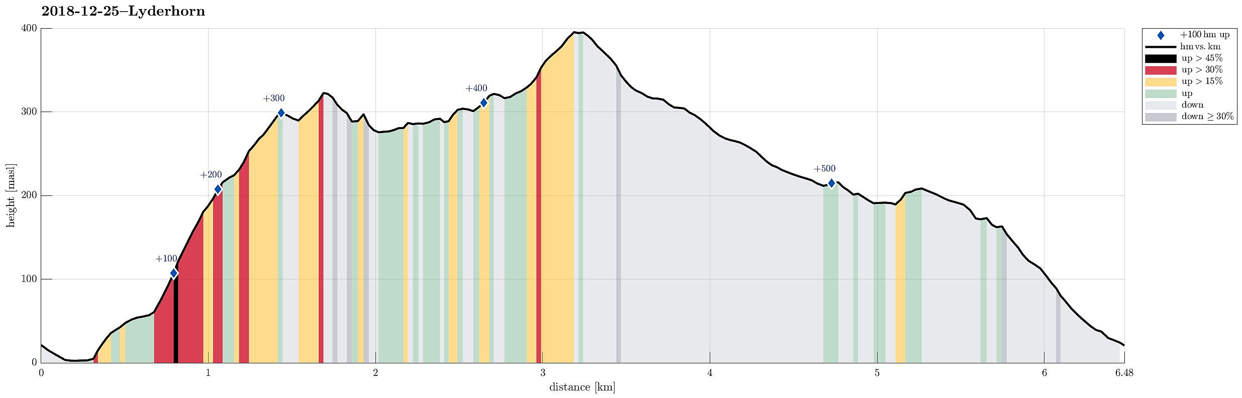 We took the car to Gravdal in order to go up to Ørnafjellet first. Instead of going up via Kvarven and the paved road there, we decided to use a minor path that leads up relatively directly from the east (half way up, one can appreciate a sign calling this ascent "Mördarbacken"). In order to get there, we used the wooden stairs behind the industrial buildings around Nutec in Gravdalsbukten. Once up the stairs, we continued through a little valley in southern direction until we came up to a place with a small soccer field. From there, the actual ascent to Ørnafjellet starts (in western direction and mostly straight upwards). Before actually getting to the top of Ørnafjellet, one reaches a small saddle near to Skåleviksvatnet. From there, it's mostly in southern direction >>>
Kanadaskogen
- Datum:
- 16.12.2018
- Tourcharakter:
- Bergtour
- Tourlänge:
- 2:00h
- Entfernung:
- 9,7km
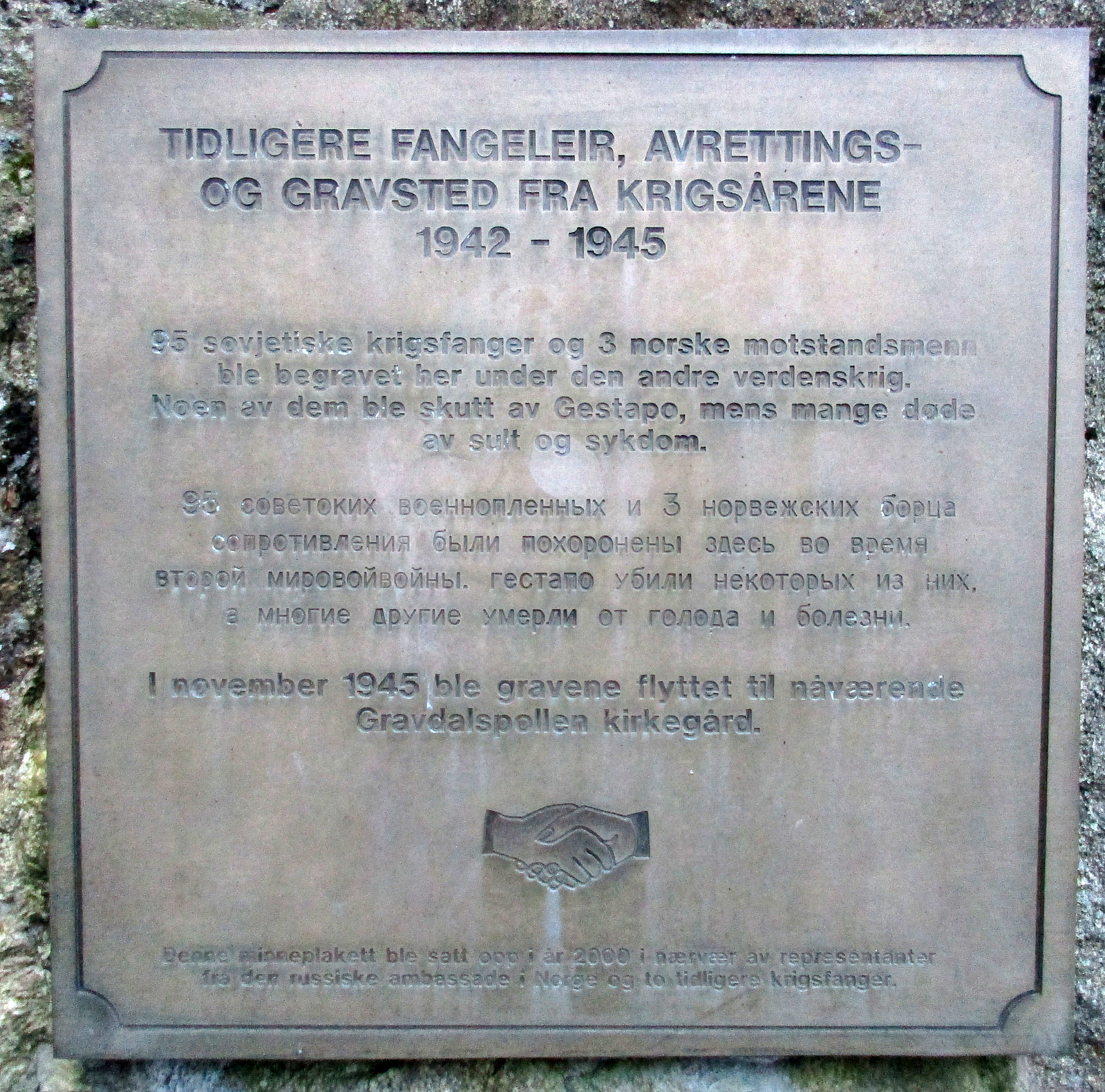 We started from Varden and wished to get some fresh air before dawn time. We first descended to Gjeddevatnet near Myratjørna. We then followed along the lakeside to Gjerdsvika, where we continued along a path that leads upwards in norther direction. Crossing over the "heights" there (between Hesjaholtet on the right / east and the lakes on the left / west), we descended towards Bjørndalsvatnet from there. We then walked along the lake until we came to its northern most bay. From there, we continued along a nice path (in northern direction), getting to Svartatjørna a little later. We passed by Svartatjørna on its western side, continuing along another nice path that connects to Tennebekk. There, we first went to this place, which reminds of some tragic deaths at the end >>>
Loneheia, Storoksla, Nesheia, and Vemånen
- Datum:
- 15.12.2018
- Tourcharakter:
- Bergtour
- Tourlänge:
- 2:00h
- Entfernung:
- 8,3km
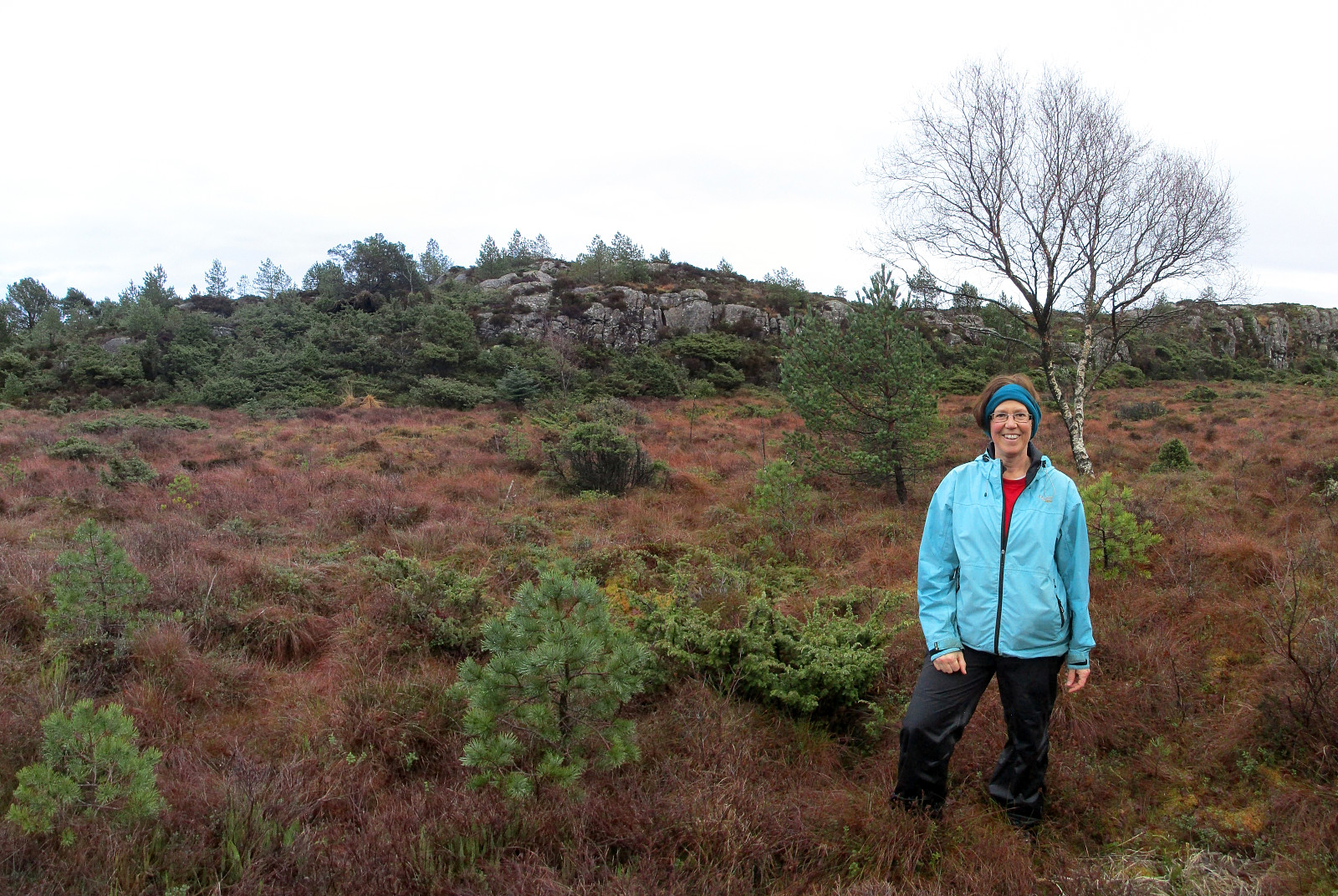
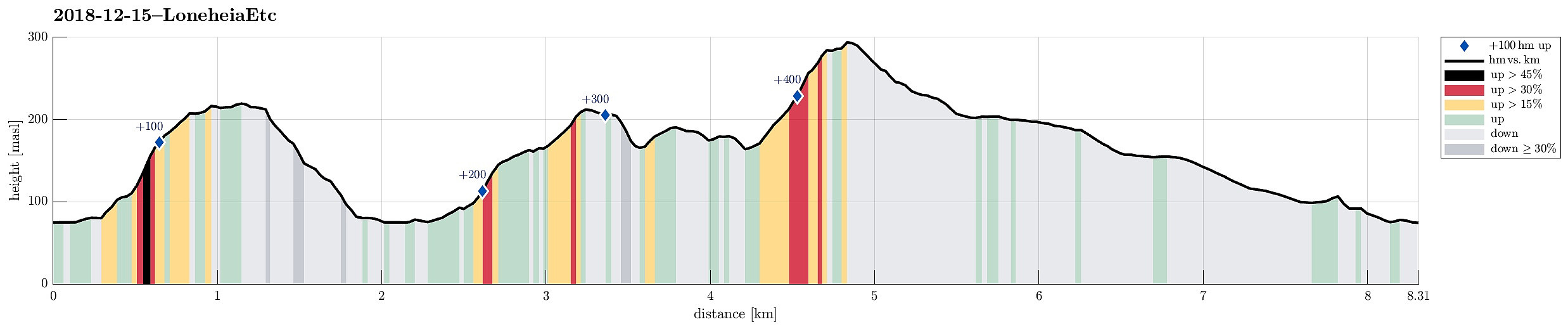 We took the car into the direction of Arna along road 580 and parked near Espeland, right next to the main road. Our first goal was to ascend to Loneheia on the northern side of the street.
We crossed the main road, the stream that runs there (from Haukelandsvatnet), and the railroad to get to Lonaleitet. There, we first followed a narrow and steep street upwards between some houses, before we changed over "into the wild" to ascend relatively directly upwards along the south-going ridge of Lonaheia. This way, we quickly arrived at the "top" of Lonaheia, also enjoying some nice views! On our way back, we followed another ridge (a bit to the east of the main ridge) and connected back to the narrow, steep street between the houses.
Our next goal was Storoksla, on the other, >>>
We took the car into the direction of Arna along road 580 and parked near Espeland, right next to the main road. Our first goal was to ascend to Loneheia on the northern side of the street.
We crossed the main road, the stream that runs there (from Haukelandsvatnet), and the railroad to get to Lonaleitet. There, we first followed a narrow and steep street upwards between some houses, before we changed over "into the wild" to ascend relatively directly upwards along the south-going ridge of Lonaheia. This way, we quickly arrived at the "top" of Lonaheia, also enjoying some nice views! On our way back, we followed another ridge (a bit to the east of the main ridge) and connected back to the narrow, steep street between the houses.
Our next goal was Storoksla, on the other, >>>
Løvstien (southern part)
- Datum:
- 08.12.2018
- Tourcharakter:
- Bergtour
- Tourlänge:
- 1:00h
- Entfernung:
- 3,9km
 We started at the southern-most end of Løvstien (at street Øvre Kråkenes and near Leknes Containerservice AS) and followed Løvstien from there, passing by Lerkhaugen in its north and Lisahaugen (basically surrounding it). Near Kopesteinen, we enjoyed a new stretch of Løvstien, which must have built quite recently, and followed it until where was no continuation (without stepping into the dark forest without a path). Instead, we turned around and walked everything back, enjoying a really nice evening, this way. :-)
See also the related FB-page Hiking around Bergen, Norway .
We started at the southern-most end of Løvstien (at street Øvre Kråkenes and near Leknes Containerservice AS) and followed Løvstien from there, passing by Lerkhaugen in its north and Lisahaugen (basically surrounding it). Near Kopesteinen, we enjoyed a new stretch of Løvstien, which must have built quite recently, and followed it until where was no continuation (without stepping into the dark forest without a path). Instead, we turned around and walked everything back, enjoying a really nice evening, this way. :-)
See also the related FB-page Hiking around Bergen, Norway .
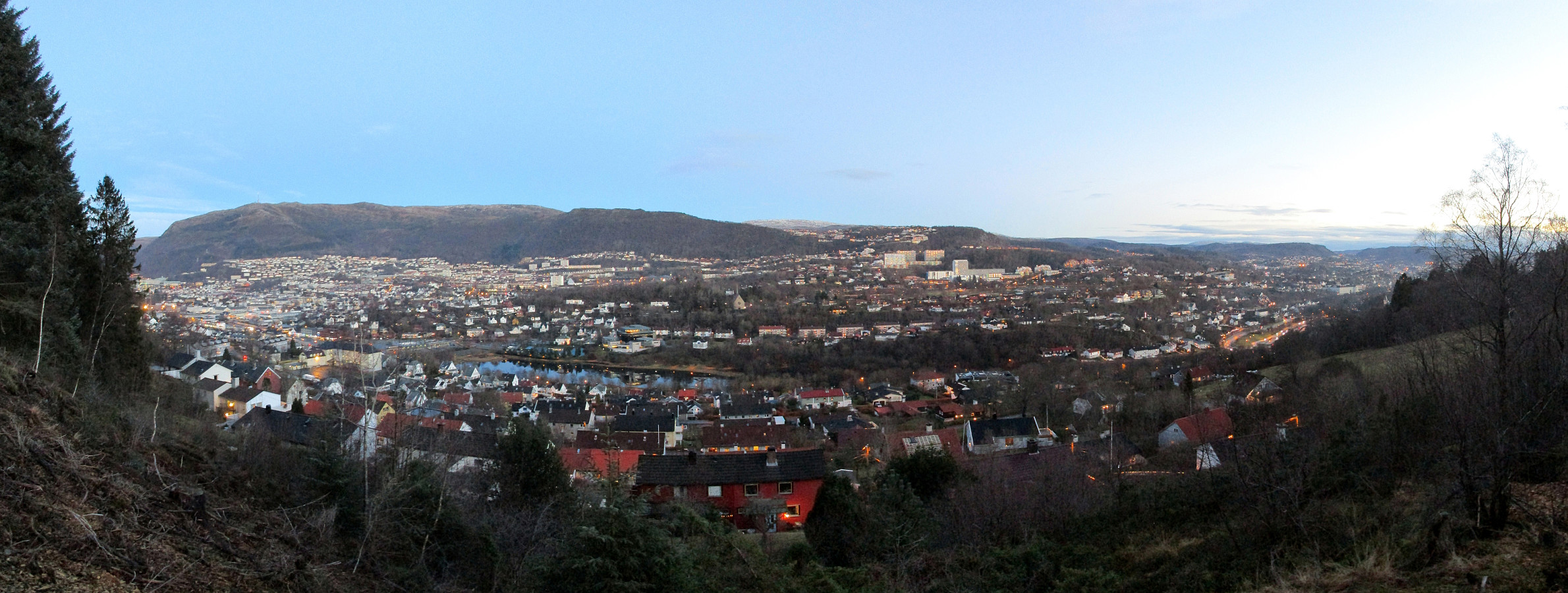
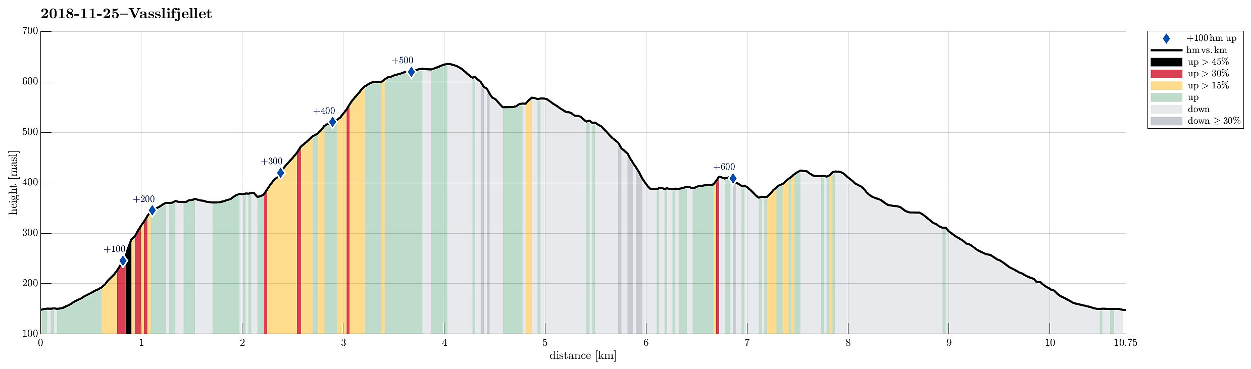
Vasslifjellet via Soleibakkane
- Datum:
- 25.11.2018
- Tourcharakter:
- Bergtour
- Tourlänge:
- 3:00h
- Entfernung:
- 10,8km
 We took the car to Sædalen, behind Nattlandsfjellet, and parked it at the lower end of Indre Sædal. From there, we first followed street Sædalssvingane upwards (in northeastern direction, towards Løypingsberget). But instead of following the road all the way to its highest point, we on the eastern side of the valley and ascended (mostly without a path there) further up there. Shortly before reconnecting with the road (at its highest point), we aligned with the water that is coming down from Søre Gløvrevatnet. We climbed further up, first on the water's eastern side, before then crossing it and ascending to the ridge that leads further up from there. There, we also found a nice path, which was easy and straight-forward to follow further upwards. Soon after, we came to Søre Gløvrevatnet >>>
Knappen
- Datum:
- 24.11.2018
- Tourcharakter:
- Bergtour
- Tourlänge:
- 1:00h
- Entfernung:
- 5,7km
 To get a little bit of fresh air, we made a quick hike over Knappen. Instead of returning via Knappetjørna and Vassteigen, we descended via Hesthaugen and returned along Sælenvatnet back to Varden.
See also the related FB-page Hiking around Bergen, Norway .
Petter Bjørstad has a useful page about Knappen .
To get a little bit of fresh air, we made a quick hike over Knappen. Instead of returning via Knappetjørna and Vassteigen, we descended via Hesthaugen and returned along Sælenvatnet back to Varden.
See also the related FB-page Hiking around Bergen, Norway .
Petter Bjørstad has a useful page about Knappen .
Bogafjellet from Reinsvegen
- Datum:
- 18.11.2018
- Tourcharakter:
- Bergtour
- Tourlänge:
- 3:45h
- Entfernung:
- 11,3km
 Even though the weather, with very low hanging clouds, did not look all to promising for a hike somewhere higher up, I still decided to give it a try and headed south and towards Fusa (via Osøyro, then taking the ferry from Hatvik to Senjaneset). Even on the ferry across Fusafjorden I wondered, whether it was that good an idea at all (the impression which the sun made, breaking through the low-hanging clouds, however, was definitely worth the view!). After arriving in Fusa, I quickly turned right from the main road and followed road 122 towards Strandvik (via Vinnes). Before actually getting to the "center" of Strandvik, I turned left and headed towards Reinsvegen. Passing by Kvåle, I drove up the valley until a spot near Snøhaugen. From there, I had planned to hike a round >>>
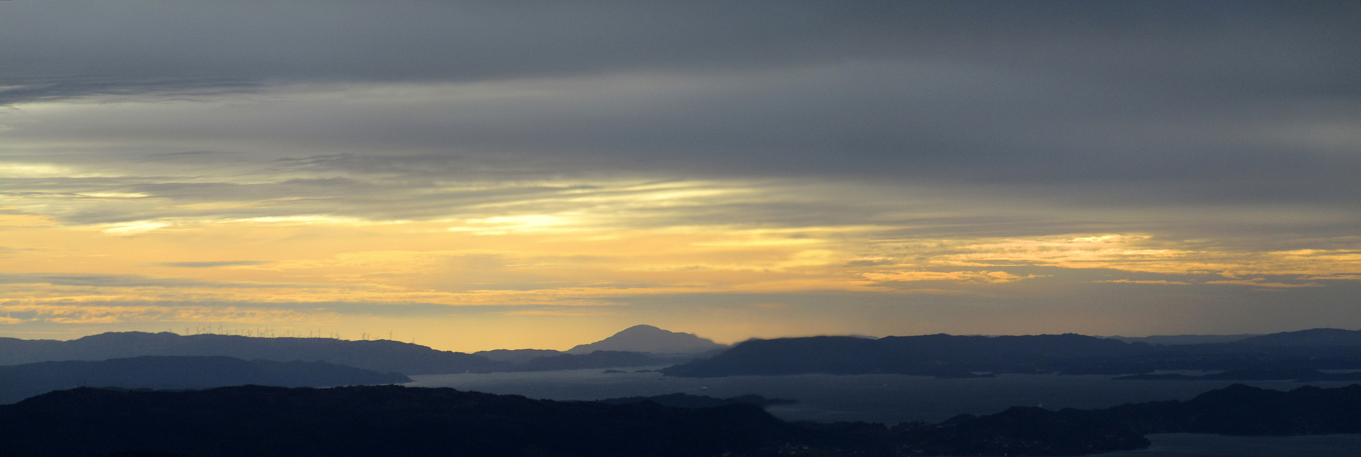
Stendafjellet at about sunset
- Datum:
- 17.11.2018
- Tourcharakter:
- Bergtour
- Tourlänge:
- 1:00h
- Entfernung:
- 3,4km
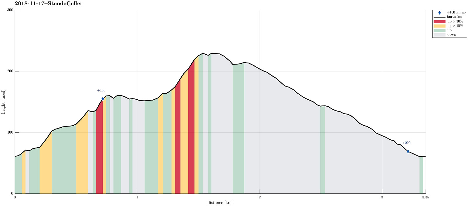 Even though it was already a bit late (for November in Bergen), there still was a chance for a short hike. From the little parking place near the previous train station at Stend (a bit north of Fana), I headed directly into the forest (in northern direction), not following the gravel road that also starts from there (a bit further east). After only a few steps, I got to a little pond (seemingly hold back by a little dam) and chose to surround it on its western side. In order to get further up, I crossed a little saddle north of the pond and ascended through the forest in northeastern direction, following one of apparently several possible routes. Once a bit further up, the terrain flattened out (a bit) and I continued in northern direction, heading towards Stendaåsen. After reaching the >>>
Løvstakken for some fresh air
- Datum:
- 04.11.2018
- Tourcharakter:
- Bergtour
- Tourlänge:
- 1:00h
- Entfernung:
- 3,1km
 Due to a lack of more time, we this time "only" made a quick hike up Løvstakken. We parked right next to Litlavatnet in Fyllingsdalen and ascended via the main path to Løvstakken from there (first towards Ravnefjellet, then around and up to Løvstakken). After a short stop at the top (in strong winds!), we returned along the same path. Always good to at least get a bit of fresh air! :-)
Selected photos are available as Google photo album .
See also the related FB-page Hiking around Bergen, Norway .
Web page WestCoastPeaks.com provides useful information about Løvstakken .
Due to a lack of more time, we this time "only" made a quick hike up Løvstakken. We parked right next to Litlavatnet in Fyllingsdalen and ascended via the main path to Løvstakken from there (first towards Ravnefjellet, then around and up to Løvstakken). After a short stop at the top (in strong winds!), we returned along the same path. Always good to at least get a bit of fresh air! :-)
Selected photos are available as Google photo album .
See also the related FB-page Hiking around Bergen, Norway .
Web page WestCoastPeaks.com provides useful information about Løvstakken .
