Archiv - Nach Datum
Archiv - Nach Aktivität
-
Andere Tour (1)
- Kayaking (1)
-
Andere Wintertour (4)
- Schneeschuhtour (4)
-
Fahrradtour (137)
- Fahrradtour Straße (9)
- Fahrradtour gemischt (51)
-
Fußtour (740)
- Bergtour (363)
- Jogging (18)
- Spaziergang (89)
- Wanderung (270)
-
Skitour (4)
- Tourenskilauf (4)
Archiv - Nach Geografie
Peakbookfreunde


Gesammelte Listen
-
Bergen ≥ 50m pf. og ≥ 100 m.o.h.
(87/89)
 97%
97% -
Most dominating tops of the Bergen peninsula
(68/75)
90%
-
Utvalgte topper og turmål i Bergen
(316/350)
90%
-
Alle topper i Bergen
(357/398)
89%
-
Opptur Bergen
(100/113)
88%
-
De syv fjell rundt Bergen
(6/7)
85%
-
Sund ≥ 50m pf.
(14/18)
77%
-
Os ≥ 50m pf.
(25/34)
73%
-
Søyler (fastmerker) i Bergen
(68/100)
68%
-
Fjell ≥ 50m pf.
(21/32)
65%

Brøknipa from Båtaleitet parking
- Datum:
- 19.07.2019
- Tourcharakter:
- Bergtour
- Tourlänge:
- 3:00h
- Entfernung:
- 5,3km
 We started from Båtaleitet parking, quite a bit above Bruvik on Osterøy (to the right, right after crossing the bridge). Following the easy-to-find trail, we soon arrived at the top of Brøknipa (Bruviknipa), enjoying some very nice views over Sørfjorden from up there (it's always wonderful to stand on top of Brøknipa -- very much recommended!). After spending a bit of time on the top, we then returned back down on the same trail that we had taken up. A nice (not too long) hike with great views! :-)
Selected photos are available as Google photo album .
See also the related FB-page Hiking around Bergen, Norway .
Petter Bjørstad has a a useful page about Brøknipa ; and also web page WestCoastPeaks.com provides useful information about Brøknipa (he writes "In my personal opinion, Brøknipa is one of Hordaland's finest mountains").
We started from Båtaleitet parking, quite a bit above Bruvik on Osterøy (to the right, right after crossing the bridge). Following the easy-to-find trail, we soon arrived at the top of Brøknipa (Bruviknipa), enjoying some very nice views over Sørfjorden from up there (it's always wonderful to stand on top of Brøknipa -- very much recommended!). After spending a bit of time on the top, we then returned back down on the same trail that we had taken up. A nice (not too long) hike with great views! :-)
Selected photos are available as Google photo album .
See also the related FB-page Hiking around Bergen, Norway .
Petter Bjørstad has a a useful page about Brøknipa ; and also web page WestCoastPeaks.com provides useful information about Brøknipa (he writes "In my personal opinion, Brøknipa is one of Hordaland's finest mountains").
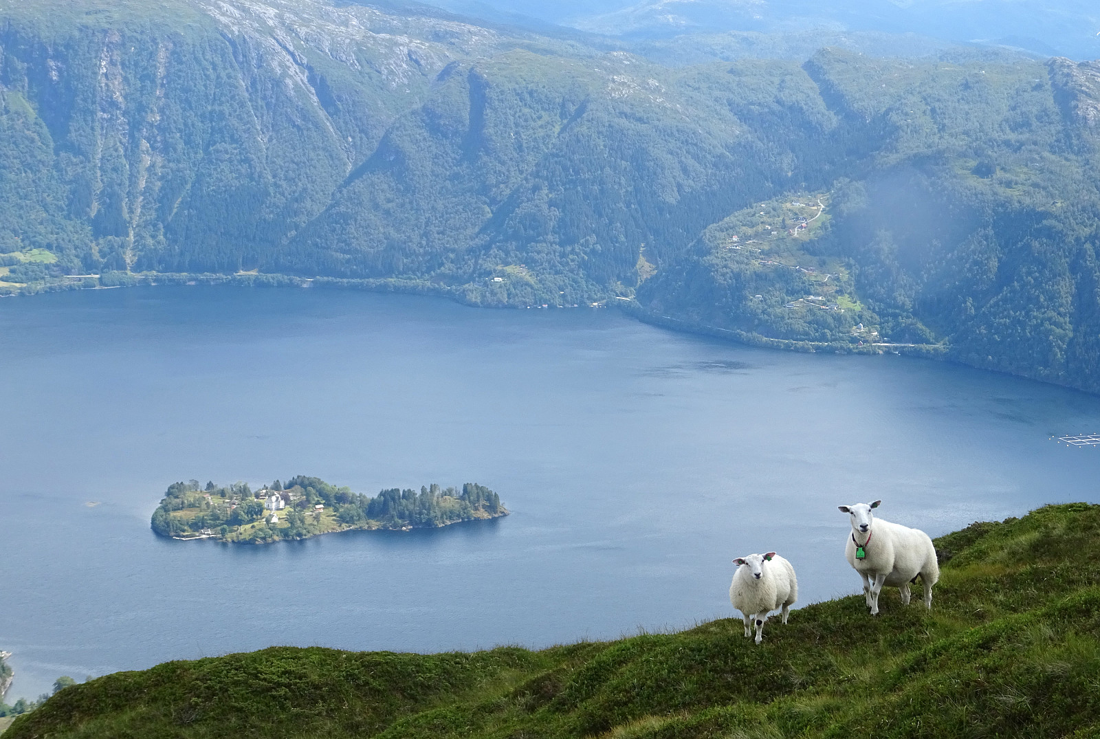
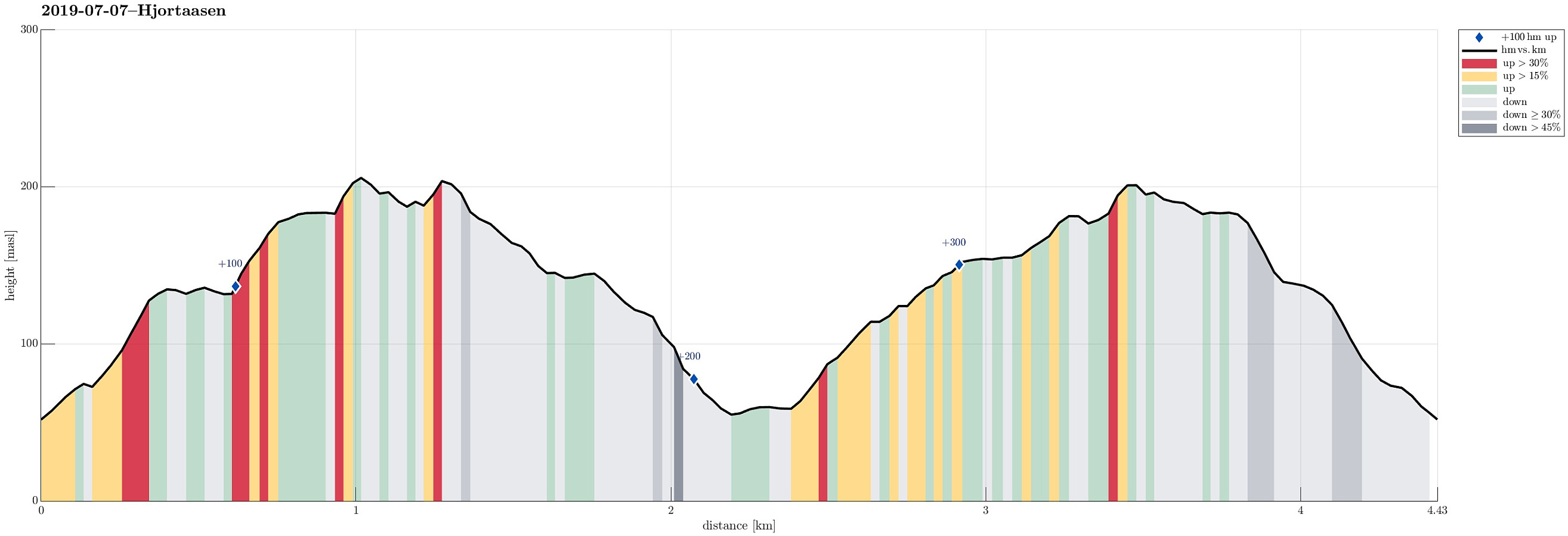
Hjortåsen on Strøno
- Datum:
- 07.07.2019
- Tourcharakter:
- Bergtour
- Tourlänge:
- 2:00h
- Entfernung:
- 4,4km
 We took the car to the south of Bergen, driving then road 160 from Ulven to Strøno. After crossing the narrow bridge to Strøno and driving up just a little to the T-junction, where the streets to Nordstrøno/Sørstrøno split, we turned right (towards Nordstrøno). Only a couple of meters before getting close to the first houses on the north-side of the island, we stopped next to the road and started hiking, following a simple forest road that starts from the street there in southwestern direction. At about 80mosl, where the forest road ends, we then continued on a well-visible path (further up in southern direction). At about 140mosl, we spotted Såta nearby (in northeastern direction) and thought that we may have a nice view from up there. It took only a few minutes to get over (no >>>
Gulltjørna via Trengereidhotten from Risnes
- Datum:
- 29.06.2019
- Tourcharakter:
- Bergtour
- Tourlänge:
- 5:45h
- Entfernung:
- 8,3km
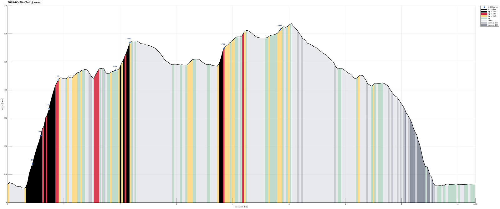 We left Bergen in eastern direction on E16 (into the direction of Voss), leaving the main road just before Romslo, changing to the old road that brings one through Romslo to Risnes. We found a suitable place to park in Risnes and started our hike from there.
Our first goal was Krånuken, to get up onto the heights north of Gullfjellet. For years, already, I had looked at this idea of ascending Trengereidhotten from the north, but hesitated (now I know that this was for good reasons!). This time, we finally decided to give it an attempt. We chose Sverinden, leading up to Krånuken, as the line and started from the street, where it passes under a short tunnel at the northern end of Sverinden. Immediately, our expectations were confirmed: the ascent over the ridge of Sverinden is very steep, >>>
We left Bergen in eastern direction on E16 (into the direction of Voss), leaving the main road just before Romslo, changing to the old road that brings one through Romslo to Risnes. We found a suitable place to park in Risnes and started our hike from there.
Our first goal was Krånuken, to get up onto the heights north of Gullfjellet. For years, already, I had looked at this idea of ascending Trengereidhotten from the north, but hesitated (now I know that this was for good reasons!). This time, we finally decided to give it an attempt. We chose Sverinden, leading up to Krånuken, as the line and started from the street, where it passes under a short tunnel at the northern end of Sverinden. Immediately, our expectations were confirmed: the ascent over the ridge of Sverinden is very steep, >>>
Skorseteggi and Kolingseggi
- Datum:
- 15.06.2019
- Tourcharakter:
- Bergtour
- Tourlänge:
- 4:00h
- Entfernung:
- 10,7km
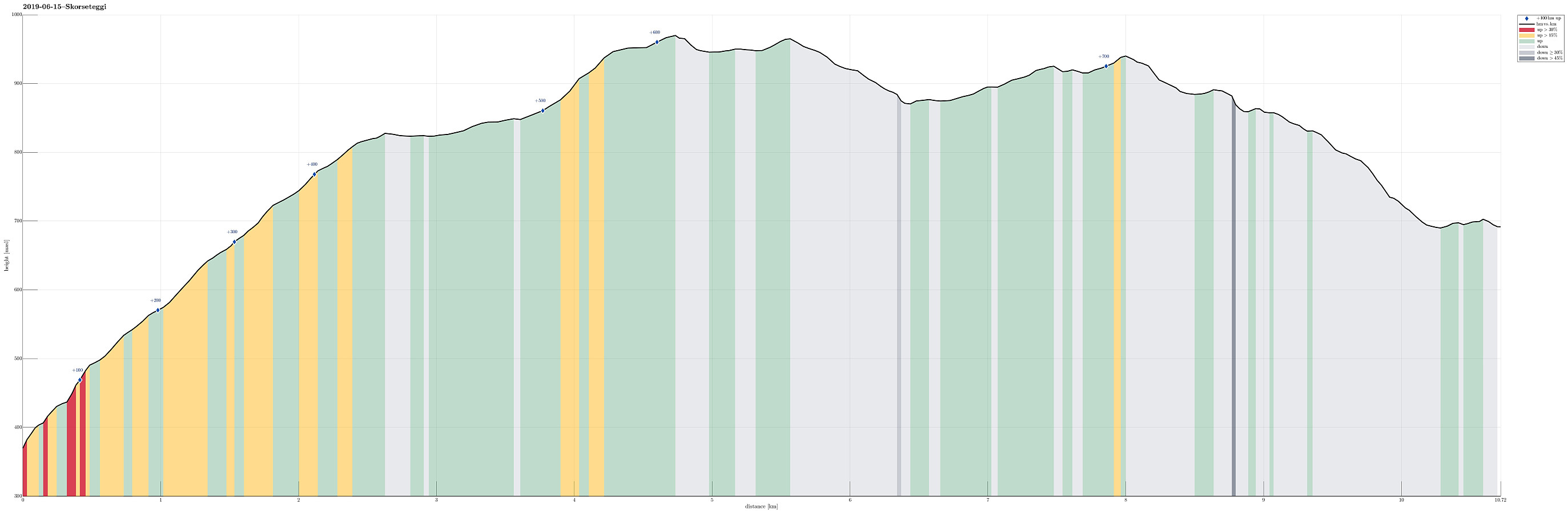 We used the advantage of having two cars this time and parked one of them near Liaset, north of Lemme and east of Lønavatnet (all near Voss). Note that you have to pay a small fee for driving the last stretch up to Liaset (NOK 20, I think), so having some coins ready may help. We then drove back to the northern side of this mountain ridge and parked near Øyjordi (near Oppheimsvatnet), where a nicely marked trail starts (back to Lemme). Following this easy-to-find trail, we ascended swiftly to Øyjordsstølen, first, and from there then further into the direction of Skorseteggi, passing by Øyjordtjørni (and Flatafjellet behind it) on our way up. Enjoying a perfect hiking day with lots of sunshine and pleasant temperatures, we spent some bonus time on the top of Skorseteggi -- simply >>>
Lyngbønipa from Lyngbø (and back via Skitnetjørna)
- Datum:
- 26.05.2019
- Tourcharakter:
- Bergtour
- Tourlänge:
- 1:15h
- Entfernung:
- 3,7km
 We took the car to Lyngbø, driving up Nipedalen a little and then parking near Nipedalen 37. From there, we first walked for a few meters along a side road (to the northeast), also called Nipedalen. Right before house 74, a narrow opening is found (in southeastern direction), which leads to the trail head on the other side of the houses. Once there, it's bascially up (in southern direction) through a small, steep valley that leads up to Nipetjørna. It's about 200hm up to the lake. In order to get to Lyngbønipa, one turns right at the lake, finding another (small) trail (again to the right, now in northern direction) very soon after. This trail then leads to Lyngbønipa (with nice views!). To get back down, we took another trail that leads down from Lyngbønipa on its southern side >>>
Sydpolen and Gullfjellet from Brekkedalen
- Datum:
- 24.05.2019
- Tourcharakter:
- Bergtour
- Tourlänge:
- 5:15h
- Entfernung:
- 14,9km
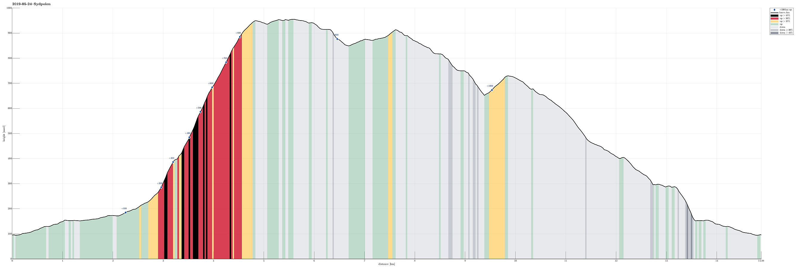 Nice to have guests, who wish to go hiking in the mountains near Bergen! :-)
The original plan was to do this on Saturday, but since the weather forecast was much better on Friday afternoon, we arranged for this timeplan instead. We left Bergen with the car into the direction of Os (on E39). After coming by Kalandsvatnet, we turned left at about Kalandseidet to enter the relatively narrow road into Hausdalen. Driving Hausdalen all the way in, we arrived at the parking place near the beginning of Brekkedalen (at the very end of the road through Hausdalen). From there, we first walked along the gravel road into Brekkedalen (in eastern direction). We came by Sandane (a nice spot in Brekkedalen!) and also took the bridge over Tverrelva, coming down from the left/north, still continuing through >>>
Nice to have guests, who wish to go hiking in the mountains near Bergen! :-)
The original plan was to do this on Saturday, but since the weather forecast was much better on Friday afternoon, we arranged for this timeplan instead. We left Bergen with the car into the direction of Os (on E39). After coming by Kalandsvatnet, we turned left at about Kalandseidet to enter the relatively narrow road into Hausdalen. Driving Hausdalen all the way in, we arrived at the parking place near the beginning of Brekkedalen (at the very end of the road through Hausdalen). From there, we first walked along the gravel road into Brekkedalen (in eastern direction). We came by Sandane (a nice spot in Brekkedalen!) and also took the bridge over Tverrelva, coming down from the left/north, still continuing through >>>
Grånipa and Gløvreegga from Vaksdal
- Datum:
- 19.05.2019
- Tourcharakter:
- Bergtour
- Tourlänge:
- 5:30h
- Entfernung:
- 14,4km
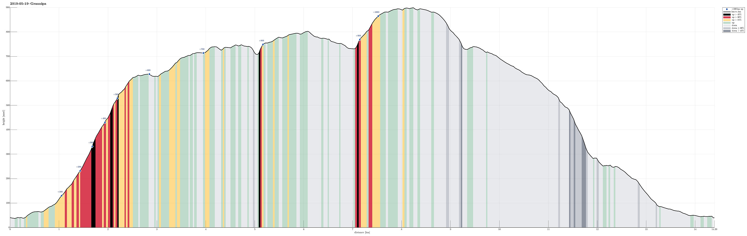 We took the car from Bergen and along E16 into the direction of Voss. At Vaksdal, we left the main road and parked only a few meters away near Vaksdal Senter. From there, we first followed the road a little further down until we crossed over the bridge to the northern part of Vaksdal. There, we followed the roads up to Flordalen. Near the house with address Flordalen 64, a sign marks the start of the trail up to Javnastølen. This trail is well visible all the way up and nice to follow (steep though). Near Lyhornet, one reaches the tree line and nice views over Sørfjorden open up (you need to turn around!). Above Lyhornet, we then followed the high ridge further towards Javnasåta (in northeastern direction). Particularly on this ridge, the views are really very nice! :-) From Javnasåta, >>>
Vedafjellet and Brøknipa from Skaftå
- Datum:
- 12.05.2019
- Tourcharakter:
- Bergtour
- Tourlänge:
- 5:15h
- Entfernung:
- 16,0km
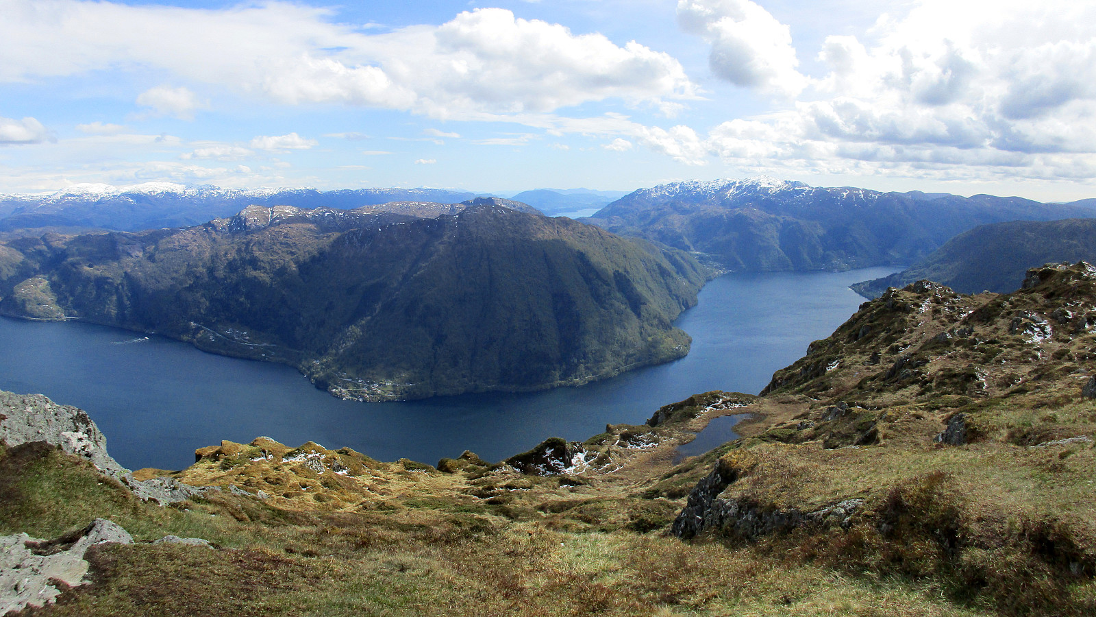 We left Bergen via Arna, continuing along road E16 in the direction of Voss, before then taking the bridge to Osterøy. On the other side, we turned right onto the narrow road towards Bruvik and followed it (on the northern side of Sørfjorden) for quite a bit. After getting around Stokkaneset and before driving into Skaftå, we parked near the sharp right-turn, which is built over the stream that comes down from Djupedalen. Right there, we forest road leaves to the north (and upwards), following Djupedalen for a short stretch (before turning left and upwards). We continued to walk up this forest road until it eventually swings to the left for good (at about 135mosl). There, we found the trail head, as planned. After a few meters of leading further northwards, the trail crosses a little >>>
Kanadaskogen and Straumsfjellet
- Datum:
- 05.05.2019
- Tourcharakter:
- Bergtour
- Tourlänge:
- 2:00h
- Entfernung:
- 7,8km
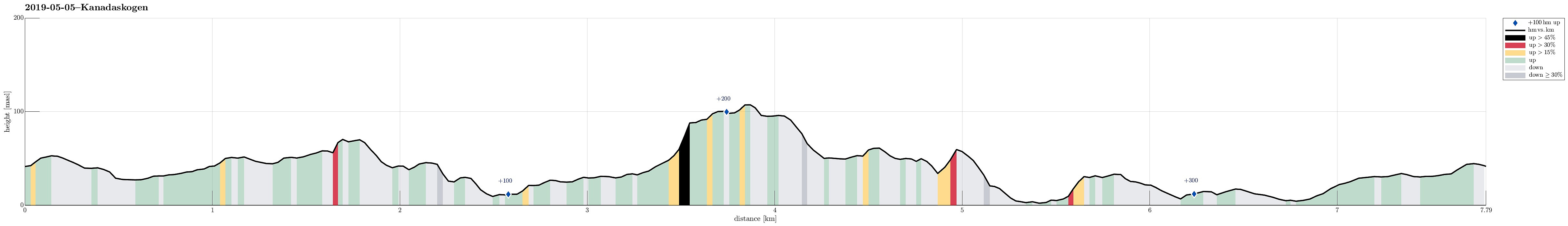 We started from Varden with no particular plan (except for getting some fresh air). We headed towards Kanadaskogen, crossing over the soccer fields north of Varden. We first followed some beaten paths between the houses until we reached Hesjaholtet. There, we eventually left streets and houses and entered the forest (Kanadaskogen). We started with some smaller heights north of Hesjaholtet, including some nice views down to Bjørndalsvatnet. After crossing some further (small) heights, we descended down to the place in the very north of Bjørndalsvatnet, where previously some building was standing (a mill?). From there, we followed a trail towards the west along the lake (in its north). This way, we rounded the southern ridge of Træshovden near the lake and then chose a gently ascending >>>
Ørnafjellet, Skjenafjellet, and Lyderhorn
- Datum:
- 01.05.2019
- Tourcharakter:
- Bergtour
- Tourlänge:
- 2:30h
- Entfernung:
- 6,7km
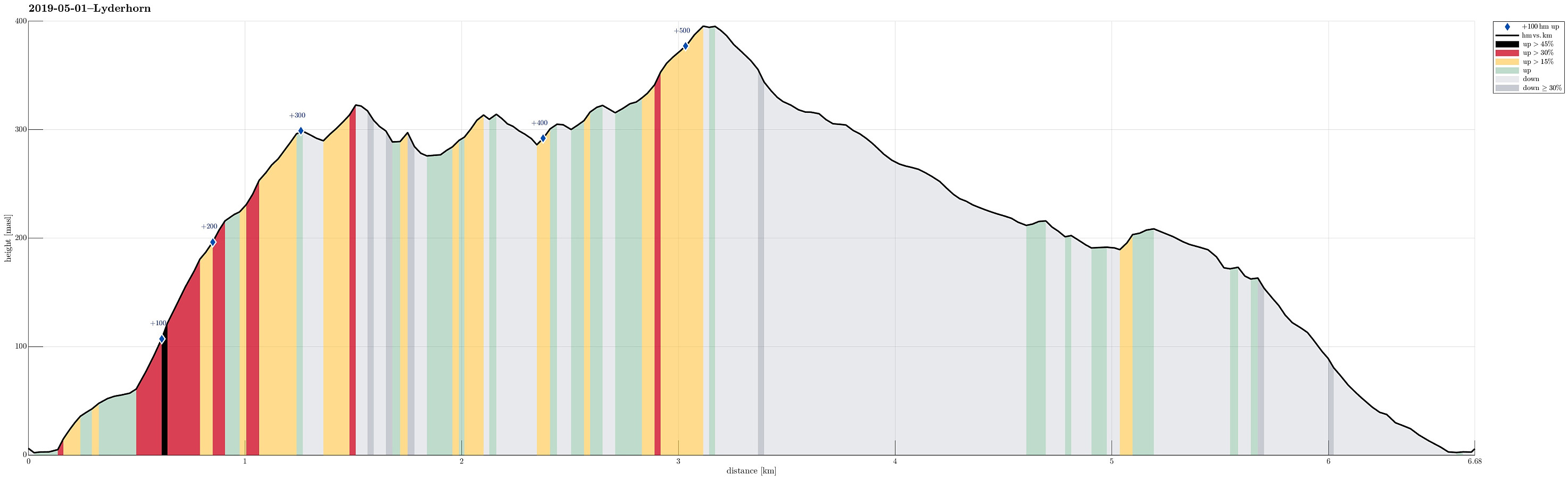 Even though the weather was not as nice as during many of the days before, we still wished to get a bit of fresh air. Since time was also limited, we decided to make a short hike on Lyderhorn. We started from the north of Gravdal, where also the street up to Kvarven leaves. Instead of starting with Kvarven, however, we decided to include Ørnafjellet (via Mördarbakka), first. To do so, we started with the stairs that lead upwards from the southern end of the industrial area at the northwestern end of Gravdal. This brings one onto a nice trail that leads through the forest in southern direction to a small soccer field (north of Øvrebø). Directly from this playing field, then in western direction and steeply upwards, you can find the trail up to Ørnafjellet. Before actually getting >>>
