Archiv - Nach Datum
Archiv - Nach Aktivität
-
Andere Tour (1)
- Kayaking (1)
-
Andere Wintertour (4)
- Schneeschuhtour (4)
-
Fahrradtour (123)
- Fahrradtour Straße (5)
- Fahrradtour gemischt (41)
-
Fußtour (736)
- Bergtour (363)
- Jogging (18)
- Spaziergang (88)
- Wanderung (267)
-
Skitour (4)
- Tourenskilauf (4)
Archiv - Nach Geografie
Peakbookfreunde


Gesammelte Listen
-
Bergen ≥ 50m pf. og ≥ 100 m.o.h.
(87/89)
 97%
97% -
Most dominating tops of the Bergen peninsula
(68/75)
90%
-
Utvalgte topper og turmål i Bergen
(313/347)
90%
-
Alle topper i Bergen
(356/398)
89%
-
Opptur Bergen
(100/113)
88%
-
De syv fjell rundt Bergen
(6/7)
85%
-
Sund ≥ 50m pf.
(14/18)
77%
-
Os ≥ 50m pf.
(25/34)
73%
-
Søyler (fastmerker) i Bergen
(68/100)
68%
-
Fjell ≥ 50m pf.
(21/32)
65%

Høgstefjellet and Tellevikafjellet
- Datum:
- 02.04.2026
- Tourcharakter:
- Wanderung
- Tourlänge:
- 4:00h
- Entfernung:
- 9,4km
 We expected a nice day and wished to make a nice hike without getting into too deep (wet) snow. The round around Baugtveitstemma, including Høgstefjellet and Tellevikafjellet, seemed just right. We found a place to leave the car behind near Salhusvegen, where one turns to towards Hitland and Baugtveit (further up the road). The original plan was to head eastwards, first, to get to a trail, which leads up to Huseberget from Salhusvegen. One from Hitland, however, was determined to avoid us going there (because of some sheep on the eastern side of Hitland). This required making up a plan B, which then basically was to ascend to Huseberget from the west (instead of from the south). Without having prepared this carefully at home, first, however, and knowing (and seeing) how steep Huseberget >>>
Morvikavarden, Olderhaug, and Geitanuken
- Datum:
- 01.03.2026
- Tourcharakter:
- Wanderung
- Tourlänge:
- 3:00h
- Entfernung:
- 7,6km
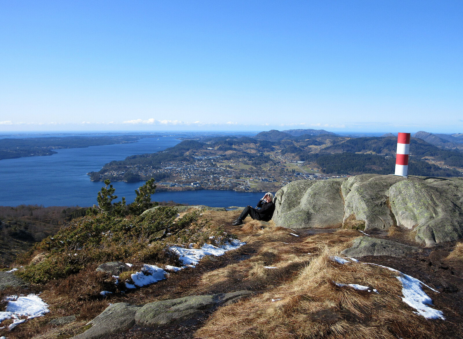
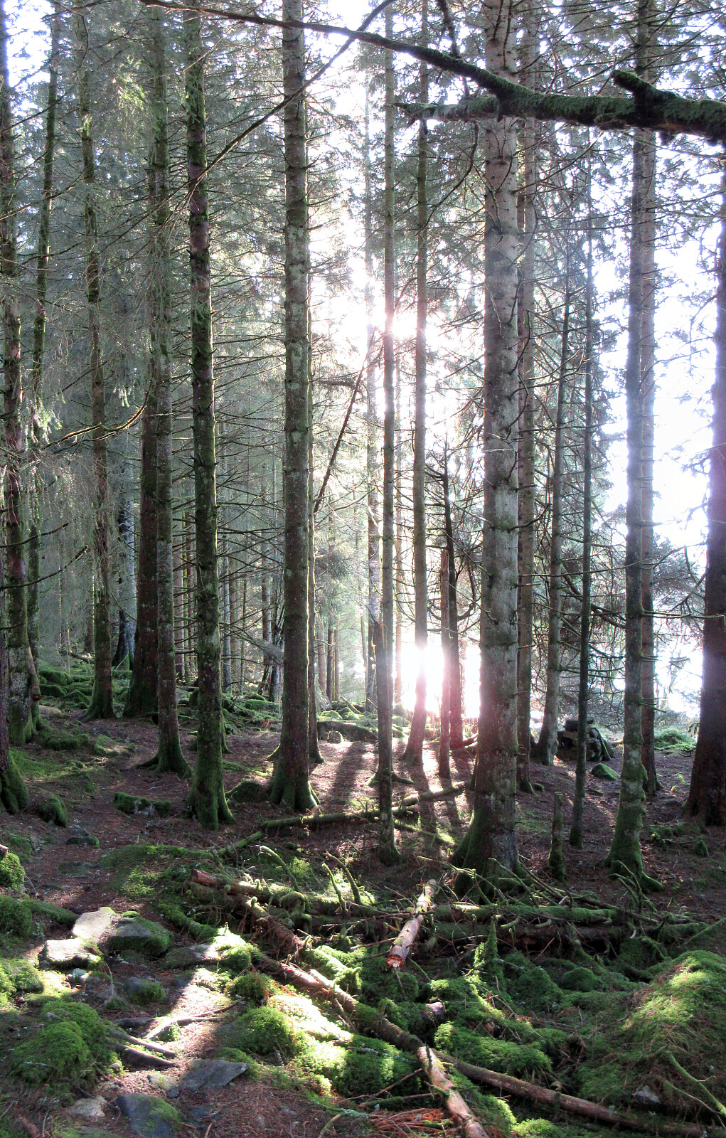
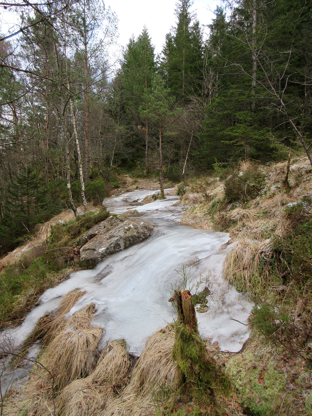
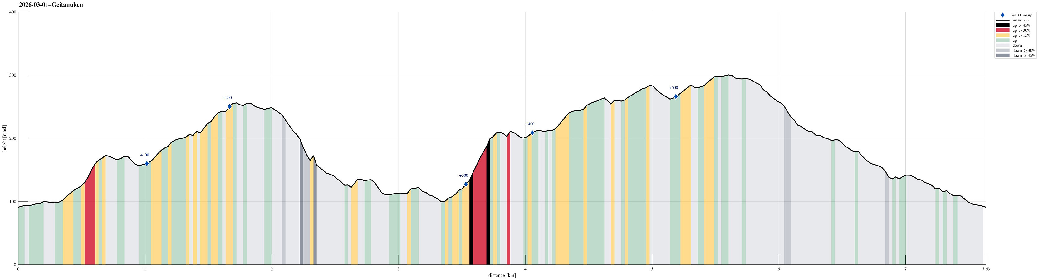 With also this Sunday inviting us to get some fresh air, we decided to visit Geitanuken again, while making it a round (an elongated one) from/to Åsane. We parked right next to Myrdalsvegen, not far from Åsane Arena, and then headed into the direction of Stornipa, first. In the northwest of Åsane Arena, we then also found a way to get over and into the forest. Stepping up to Stornipa was then just a question of a few minutes and the forest is actually quite nice there. Next, we wished to explore Morvikavarden and to get there, we crossed over Stornipa to connect with road Myrdalskogen in the north. On the northwestern side of "the big bend" of Myrdalskogen, we found an opportunity to "short-cut" further upwards through the forest. After yet again walking along Myrdalskogen >>>
Vassberget, Kvamsfjellet, and Tveitavarden
- Datum:
- 28.02.2026
- Tourcharakter:
- Wanderung
- Tourlänge:
- 4:00h
- Entfernung:
- 10,0km
 We expected a nice day and wished to make a nice, moderate hike with a chance to catch some sun, also. After first looking at Tveitavarden, Kvamsfjellet, and Vassberget, north of Knarvik, we then found a description of a hike over these hills, but in reverse order, providing additional motivation to explore this part of Alver. After driving there from Bergen, we parked right next to Lindåsvegen, where Årdalen comes down from the northwest. Walking up Årdalen, we then found the trail head for Vassberget, which is nicely marked with a sign. Following this trail, we quickly made it up the ridge in the southwest of Kråkstidalen, but instead of crossing over this valley (as the main trail does), we continued further northwards on the ridge (into the direction of Litlevassberget). At times and with some phantasy, >>>
Fanafjellet from Fana
- Datum:
- 25.01.2026
- Tourcharakter:
- Wanderung
- Tourlänge:
- 3:30h
- Entfernung:
- 7,1km
 We thought that all the frozen ground condition would be just right for an excursion to Fanafjellet (which on a regular day can be very wet, especially when walking around up there off-trail). We parked in Fana near Fanastølen and then started our hike with a short ascent to Marietoppen. While Marietoppen is just a small hill, it is actually interesting to find extended remains from WWII defense structures on its top. After this initial visit to Marietoppen, we then aimed to find a good way up to Fanafjellet. While we first considered checking an opportunity to do this "straight up" in the south of Marietoppen, we then decided that walking a small detour via Saganeset would bring us nicely up to a proper trail at Høgaberget. When near Bukkamyrane at about 175masl, we then followed >>>
Ørnafjellet and Lyderhorn from Nedberget
- Datum:
- 24.01.2026
- Tourcharakter:
- Wanderung
- Tourlänge:
- 3:00h
- Entfernung:
- 7,6km
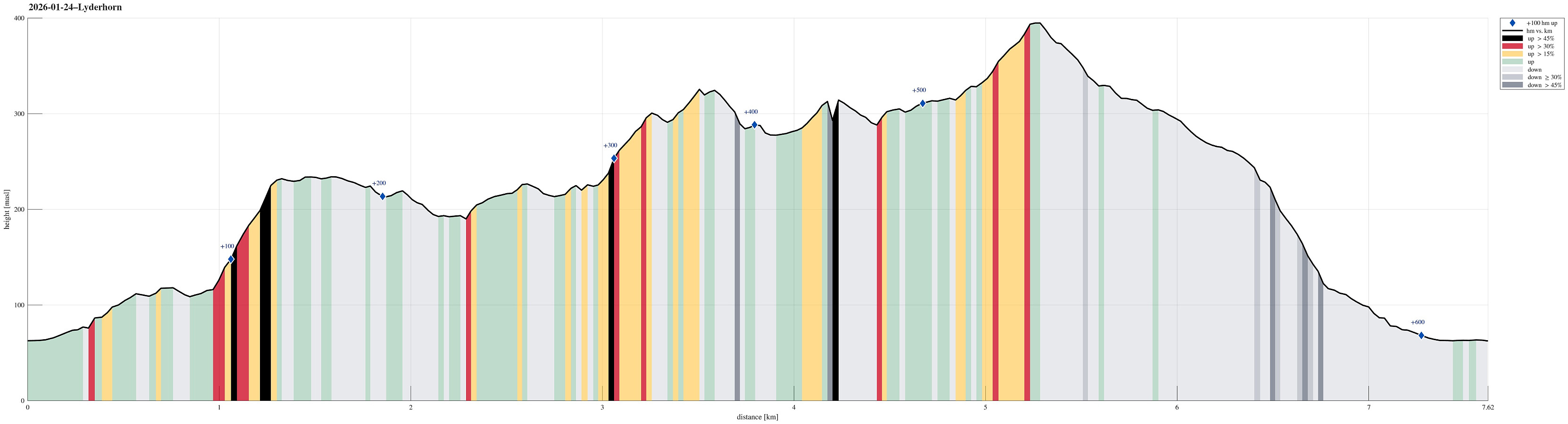 We aimed at some nice excursion, not too far out, and chose Ørnafjellet, i.e., the little sister or brother of Lyderhorn. To get there, we decided to park near Nedberget at Kjøkkelvik and hike up from there. The ascent through the forest was just fine, even though there was quite a bit of ice (especially in the rather narrow part before reaching the heights). Once up, we then started to surround Skåleviksvatnet in order to get over to Ørnafjellet and ascend it from the north. After visiting Ørnafjellet, we continued our little round on the heights to Skjenafjellet. There, we decided that including Lyderhorn, also, was just the right thing to do. After visiting Lyderhorn, then, we just walked back down to Nedberget to complete the hike.
Selected photos are available as Google photo album .
See also the >>>
We aimed at some nice excursion, not too far out, and chose Ørnafjellet, i.e., the little sister or brother of Lyderhorn. To get there, we decided to park near Nedberget at Kjøkkelvik and hike up from there. The ascent through the forest was just fine, even though there was quite a bit of ice (especially in the rather narrow part before reaching the heights). Once up, we then started to surround Skåleviksvatnet in order to get over to Ørnafjellet and ascend it from the north. After visiting Ørnafjellet, we continued our little round on the heights to Skjenafjellet. There, we decided that including Lyderhorn, also, was just the right thing to do. After visiting Lyderhorn, then, we just walked back down to Nedberget to complete the hike.
Selected photos are available as Google photo album .
See also the >>>
Førdesveten from Kleppe
- Datum:
- 27.12.2025
- Tourcharakter:
- Wanderung
- Tourlänge:
- 2:30h
- Entfernung:
- 8,1km
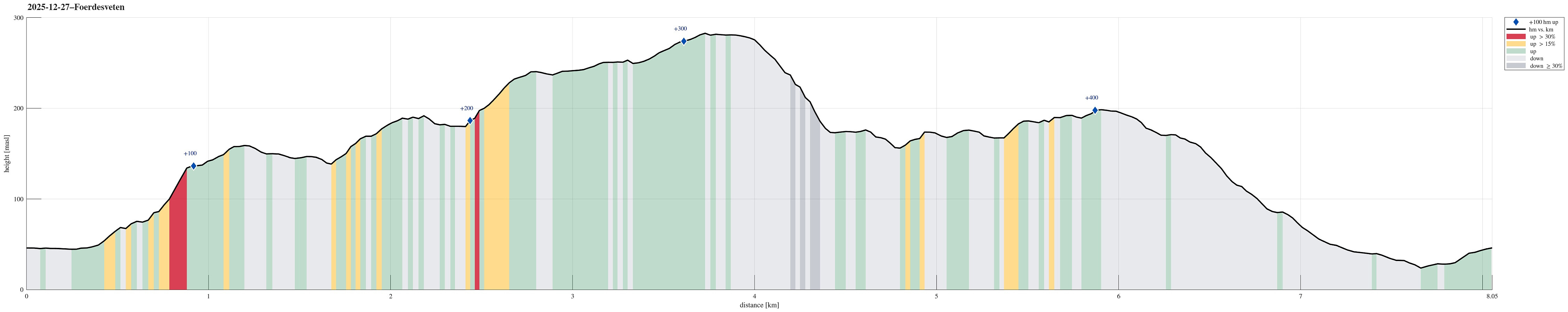 Yes, quite some wind was predicted, but still the weather seemed too good to not go out for a short while. After enjoying a nice round around Dyrdalsvatnet the day before, we decided that it should be Førdesveten south in Øygarden this day. We parked in Kleppe and took the route via Høylandsfjellet, Midtfjellet, and Lyngfjellet up to Veten. The higher we got, the more we experienced the rather strong winds! Near the top, we then took a short break in the still relatively new Dagsturhytten before heading back down via Ramnaberget and Kleppaksla. On the way down from Kleppaksla, we found a trail with pink markers in the southwest of Fenadalen, which brought us down to Sundvegen not far from where we had parked.
Selected photos are available as Google photo album .
See also the related FB-page Hiking around Bergen, Norway .
Petter Bjørstad has a useful page about Veten and also web page WestCoastPeaks.com provides useful information about Førdesveten .
Web >>>
Yes, quite some wind was predicted, but still the weather seemed too good to not go out for a short while. After enjoying a nice round around Dyrdalsvatnet the day before, we decided that it should be Førdesveten south in Øygarden this day. We parked in Kleppe and took the route via Høylandsfjellet, Midtfjellet, and Lyngfjellet up to Veten. The higher we got, the more we experienced the rather strong winds! Near the top, we then took a short break in the still relatively new Dagsturhytten before heading back down via Ramnaberget and Kleppaksla. On the way down from Kleppaksla, we found a trail with pink markers in the southwest of Fenadalen, which brought us down to Sundvegen not far from where we had parked.
Selected photos are available as Google photo album .
See also the related FB-page Hiking around Bergen, Norway .
Petter Bjørstad has a useful page about Veten and also web page WestCoastPeaks.com provides useful information about Førdesveten .
Web >>>
Slettegga, Austefjellet, and Hausdalshorgi
- Datum:
- 26.12.2025
- Tourcharakter:
- Wanderung
- Tourlänge:
- 5:00h
- Entfernung:
- 13,3km
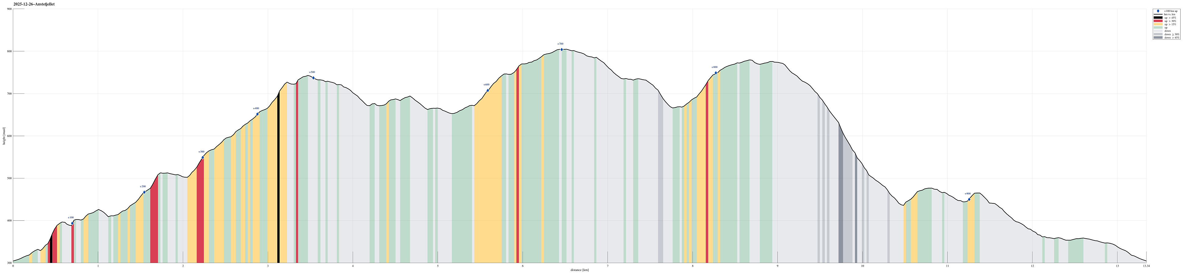 We expected a nice winter day and started a bit earlier than usually to exploit the short daylight period as well as possible. After driving up to Bontveit and parking there right next to the saddle, we started first hiking northwards along Bontveitvegen. Very soon, however, we turned left to explore Åsane (in parallel to Bontveitvegen). While it was fully possible to traverse Åsane, also without any trail, it occasionally got a touch of a nice xMas bush war. At Langemyrskaret, we reconnected with Bontveitvegen, having a nice chat with another hiker, who had enjoyed the rising sun from Slettegga. Then, instead of following the standard trail up to Slettegga, we included another small exploration: Halvardshaugen in the northwest of Bjørnstølåsen, from which we enjoyed some really nice >>>
Løvstakken from/to Bergen
- Datum:
- 25.12.2025
- Tourcharakter:
- Wanderung
- Tourlänge:
- 1:30h
- Entfernung:
- 6,7km
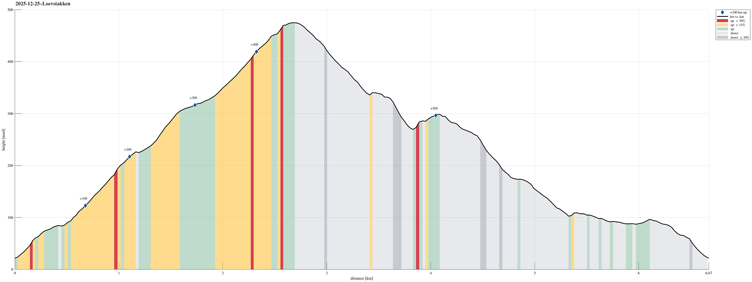 Even though it was a bit late, already, we still wished to make a quick round somewhere near. Doing Løvstakken from the Bergen-side seemed just right (and so it was). We used the gravel road that starts from Løvstien just above Solheimslien to get up. On Løvstakken, we met an unexpected sight: most of one of the two masts was missing from its top -- what's happening? :-) To get back down, we chose to cross over Ravnefjellet and then use Løvstien to get back around to the Bergen-side. Our timing was just right to return before it got all dark.
Selected photos are available as Google photo album .
See also the related FB-page Hiking around Bergen, Norway .
Web page WestCoastPeaks.com provides useful information about Løvstakken .
Even though it was a bit late, already, we still wished to make a quick round somewhere near. Doing Løvstakken from the Bergen-side seemed just right (and so it was). We used the gravel road that starts from Løvstien just above Solheimslien to get up. On Løvstakken, we met an unexpected sight: most of one of the two masts was missing from its top -- what's happening? :-) To get back down, we chose to cross over Ravnefjellet and then use Løvstien to get back around to the Bergen-side. Our timing was just right to return before it got all dark.
Selected photos are available as Google photo album .
See also the related FB-page Hiking around Bergen, Norway .
Web page WestCoastPeaks.com provides useful information about Løvstakken .
Lyderhorn via Skarpafjellet
- Datum:
- 06.12.2025
- Tourcharakter:
- Wanderung
- Tourlänge:
- 1:30h
- Entfernung:
- 4,5km
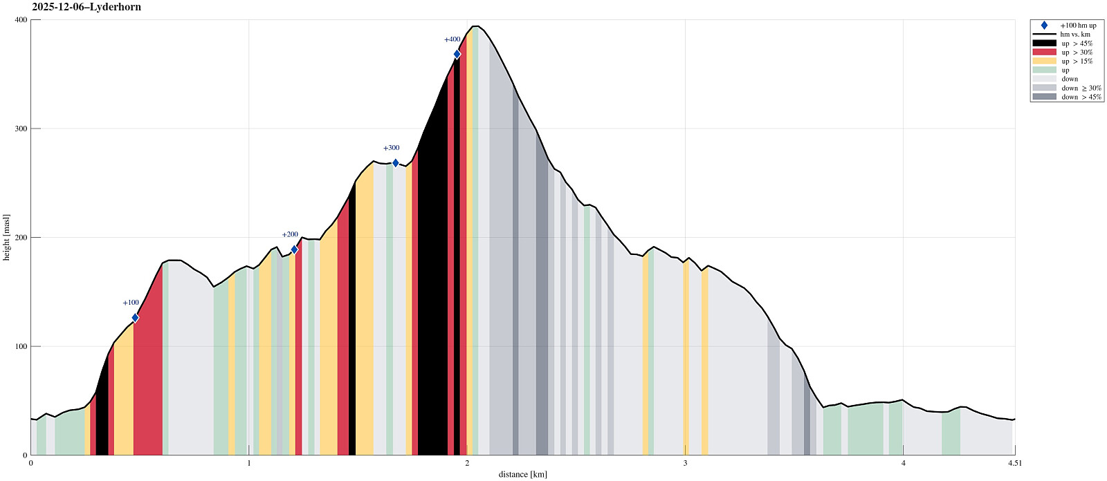 Aiming at some nice but not too long weekend hike, we decided to visit Lyderhorn (again). The plan was to ascend via Skarpafjellet in the south of Lyderhorn. We parked at Bjørndalen and tried an as direct as possible (off-trail) ascent to Skarpafjellet, first. As soon as we had left road Sildaberget (right next to Lyderhornsveien), we immediately found ourselves (not unexpectedly, though) in rather steep terrain, which required a bit of hand help to make it up between the rocks. As soon as we were up to about 90masl, however, progress became easier and rather straight-forward -- all the way to the top of Skarpafjellet. This southern flank of Skarpafjellet is actually very nice, offering some nice views over Bjørndalen and Bjørndalspollen. From Skarpafjellet, we then followed the main >>>
A dragon on Knappen?
- Datum:
- 29.11.2025
- Tourcharakter:
- Wanderung
- Tourlänge:
- 1:30h
- Entfernung:
- 5,5km
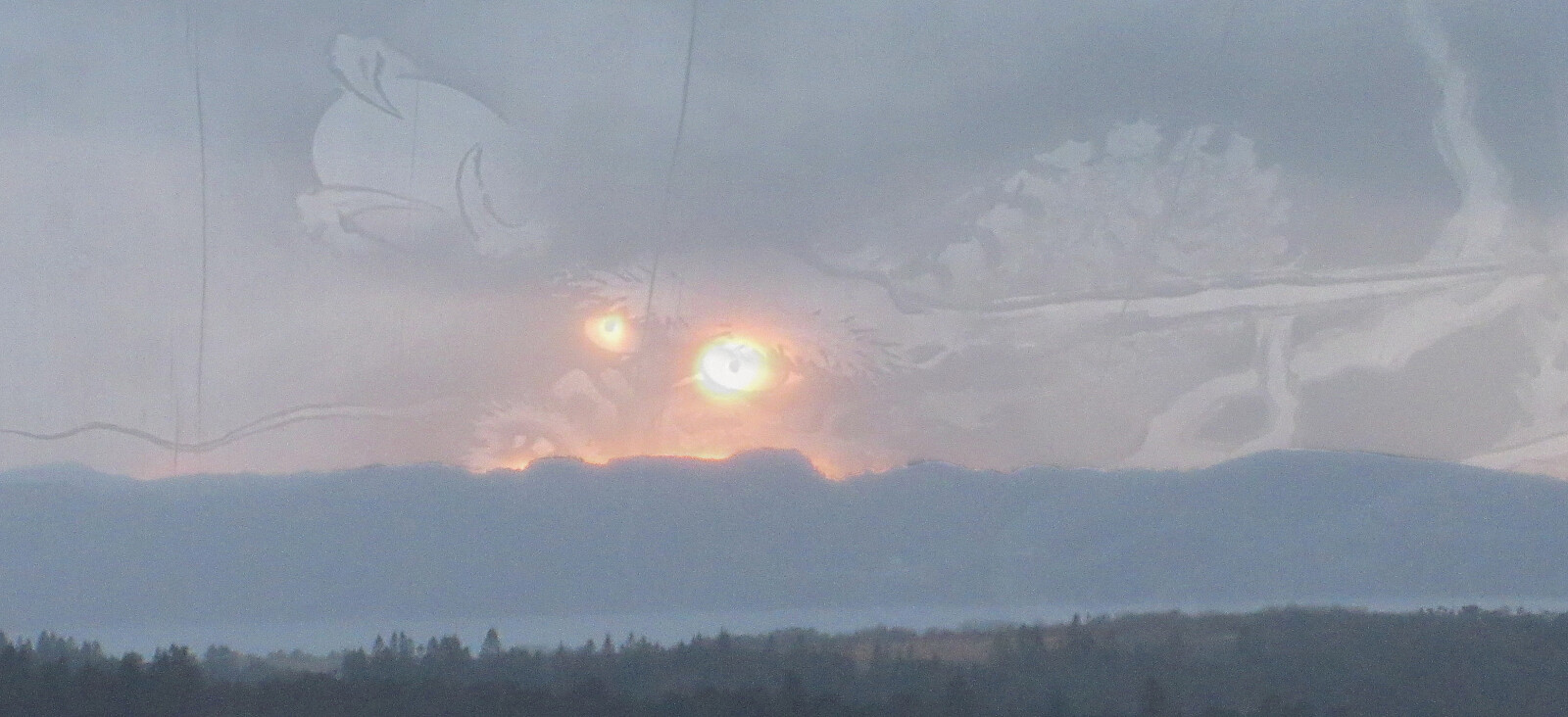 When the winter days are short, it's sometimes no more than "just" making a quick (but still nice!) round across Knappen! :-)
Selected photos are available as Google photo album .
See also the related FB-page Hiking around Bergen, Norway .
Petter Bjørstad has a useful page about Knappen .
Web page UT.no from the Norwegian Trekking Association recommends another hike to Knappen .
When the winter days are short, it's sometimes no more than "just" making a quick (but still nice!) round across Knappen! :-)
Selected photos are available as Google photo album .
See also the related FB-page Hiking around Bergen, Norway .
Petter Bjørstad has a useful page about Knappen .
Web page UT.no from the Norwegian Trekking Association recommends another hike to Knappen .
