Archiv - Nach Datum
Archiv - Nach Aktivität
-
Andere Tour (1)
- Kayaking (1)
-
Andere Wintertour (4)
- Schneeschuhtour (4)
-
Fahrradtour (123)
- Fahrradtour Straße (5)
- Fahrradtour gemischt (41)
-
Fußtour (736)
- Bergtour (363)
- Jogging (18)
- Spaziergang (88)
- Wanderung (267)
-
Skitour (4)
- Tourenskilauf (4)
Archiv - Nach Geografie
Peakbookfreunde


Gesammelte Listen
-
Bergen ≥ 50m pf. og ≥ 100 m.o.h.
(87/89)
 97%
97% -
Most dominating tops of the Bergen peninsula
(68/75)
90%
-
Utvalgte topper og turmål i Bergen
(313/347)
90%
-
Alle topper i Bergen
(356/398)
89%
-
Opptur Bergen
(100/113)
88%
-
De syv fjell rundt Bergen
(6/7)
85%
-
Sund ≥ 50m pf.
(14/18)
77%
-
Os ≥ 50m pf.
(25/34)
73%
-
Søyler (fastmerker) i Bergen
(68/100)
68%
-
Fjell ≥ 50m pf.
(21/32)
65%

Møsnuken from Tyssdalen
- Datum:
- 13.11.2021
- Tourcharakter:
- Wanderung
- Tourlänge:
- 4:30h
- Entfernung:
- 9,7km
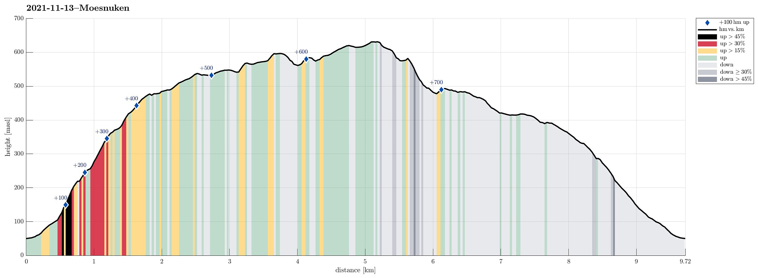 As a small group of four, we wished to some nice autumn hiking in quite fine weather. To also enjoy some views across the nice fjord-landscape around Bergen, we decided to make "the standard hike" up to Møsnuken. Taking E39 south from Bergen, we soon passed by Kalandsvatnet and then Syfteland. A little further south, just before the roundabout at Ulven, we turned left and onto Tøsdalsvegen. In the south of Tyssdalsvatnet, we crossed over a small bridge and parked soon after at the parking spot for hikers right next to Tyssdalselva. Starting our hike on the main trail towards Møsnuken, we crossed Tyssdalselva after just a few meters. Then, after just following the main trail for a few further meters, we turned left to do the ascent to Møsnuken via Linken. This (also very >>>
Nice round around Bysheimvatnet
- Datum:
- 31.10.2021
- Tourcharakter:
- Wanderung
- Tourlänge:
- 5:30h
- Entfernung:
- 16,1km
 The weather forecast had improved and promised nice hiking conditions, which let us decide for a "proper" hike. :-) For some time already, we had looked at Skolmen on Osterøy and now a hike up there seemed just right to us. We drove from Bergen to Osterøy (via the bridge) and on Osterøy further to Gjerstad. Continuing past Gjerstad church and Skistad on Gjerstadvegen, we turned right on the other side of the stream, leading us towards Solbjørg. Taking the next turn to the left, we started our passage through Solbjørgsdalen, before turning right, again, at Rymla, driving eastwards into the direction of Låstadvatnet. After passing by the rather large business area next to the stream that comes out of Låstadvatnet, we parked at the side of the road and started hiking from >>>
Klyvsnolten and Lauvhovden
- Datum:
- 19.10.2021
- Tourcharakter:
- Wanderung
- Tourlänge:
- 3:00h
- Entfernung:
- 7,8km
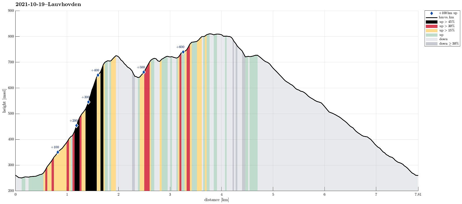 After a two days meeting at Voss, we wished to get some fresh air before darkness would set in. The weather forecast was "challenging" (loads of rain predicted), but shifted at least a little from day to day. We had not given up, but aimed at something non-extreme to account for the circumstances (limited daylight left, non-shiny weather, etc.). My dear hiking friend Harald wished to ascend Lauvhovden (and convinced me then, also). We took the car from Voss along Raundalsvegen to Klyve, where we parked near Svinåni next to a gravel road. To start our hike, we first followed Raundalsvegen a little further, passing between Øvre Klyve and Nedre Klyve, to connect to a forest road that we had seen right next to Rastalii (leading upwards into the direction of Skori and Klyvsnolten). Following >>>
Ulriken via Ulrikseggen
- Datum:
- 17.10.2021
- Tourcharakter:
- Wanderung
- Tourlänge:
- 5:00h
- Entfernung:
- 13,9km
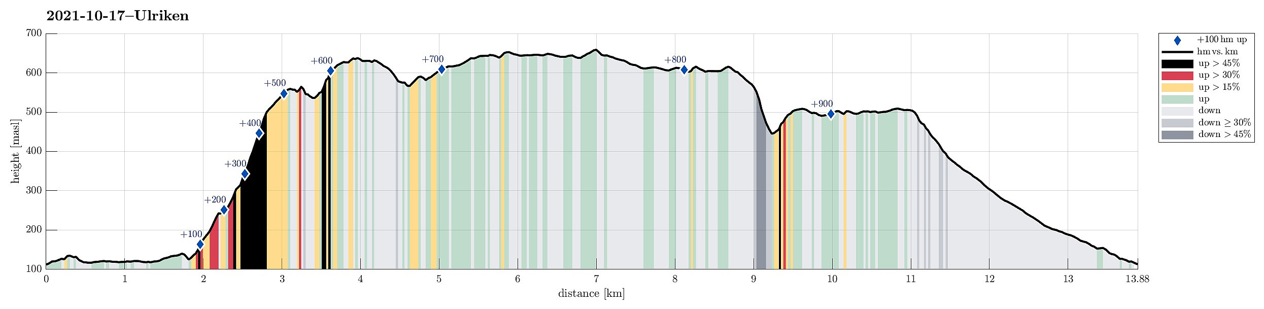 With a remarably nice Sunday ahead of us, we decided to make a round over (parts of) Vidden, starting with an ascent to Ulriken via Ulrikseggen. After first cycling to Svartediket (and a bit along it on its northern side), we started to hike not far from Koftebrotet, following the gravel road, first. This way, we passed by Hardbakkadalen and then also Isdalen, surrounding Svartediket on its eastern and then southern side. After crossing the stream that comes down Isdalen (and not following the Isdalen-trail upwards from there as one also could), we continued a little further along the gravel road until it makes a moderate turn to the right (north), leading down to Karistølen from there. It is in this turn that one can start the actual ascent via Ulrikseggen, following a trail through the forest (upwards in >>>
Nice hike around Hisdalsvatnet
- Datum:
- 09.10.2021
- Tourcharakter:
- Wanderung
- Tourlänge:
- 4:45h
- Entfernung:
- 10,2km
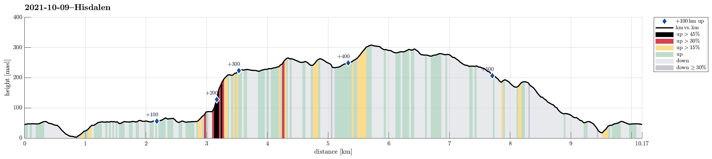 The weather forecast was OK and it looked like there was a good opportunity for a nice hike in the neighborhood. For a longer time already, the Hisdalen nature reserve had (silently) recommended itself and so we decided to pay this somewhat separated part of Bergen ("separated" in the sense that it's kind of "behind the hills of Fanafjellet") a visit. We took the car via Fana to Krokeide, where we parked next to the road (near the saddle before one drives down to the ferry terminal at Krokeide). We then walked (first along a minor road) into the direction of Austrevågen (in eastern direction), before continuing along the forest road towards the southwestern end of Hisdalsvatnet. There, our goal of crossing the stream out of Hisdalsvatnet was challenged by the large >>>
Lyderhorn (between two showers)
- Datum:
- 02.10.2021
- Tourcharakter:
- Wanderung
- Tourlänge:
- 1:30h
- Entfernung:
- 3,1km
 Given a rather wet day with showers coming through one after the other, we grabbed the chance of one rain break and included a short hike up to Lyderhorn (from Kjøkkelvikveien). We started along Lyderhornslien (into the direction of Olderdalen), but then chose to take the somewhat less used route up that has its trail head between Lyderhornslien 120 and 122 (some steps up, first, from between the houses). The trail is by now much better visible and it's easy to follow it upwards into the direction of Lyderhorn (first in southeastern direction, before turning left into north eastern direction). From 250mosl upwards, one can then also enjoy some nice views (mostly in western direction). From Lyderhorn, we then took the more popular route down (first in southern direction until close to Små-Lyderhorn, >>>
Eggene (and back via Raudlifjellet)
- Datum:
- 19.09.2021
- Tourcharakter:
- Wanderung
- Tourlänge:
- 3:00h
- Entfernung:
- 6,9km
 With most of the day overcast, the day's goal was an excursion into the forest in the southeast of Hausdalen. We drove first along E39 into the south of Bergen, parking not far from this road near Bahus. From there, we first walked along the road, crossing Straumen on the road's bridge, before quickly finding a tractor road that would lead us behind the houses (in northeastern direction, towards Storerinden). Once past the houses, we also left the tractor road, ascending to the gentle ridge (Storerinden). Once on the ridge, it was then straight-forward and easy to follow it (in northeastern direction). This way, one gets directly to Høghaugen (in the northwest of Breidalen) with some first nice views into Hausdalen (and down to Hauglandsvatnet). To connect further to Eggene, one needs >>>
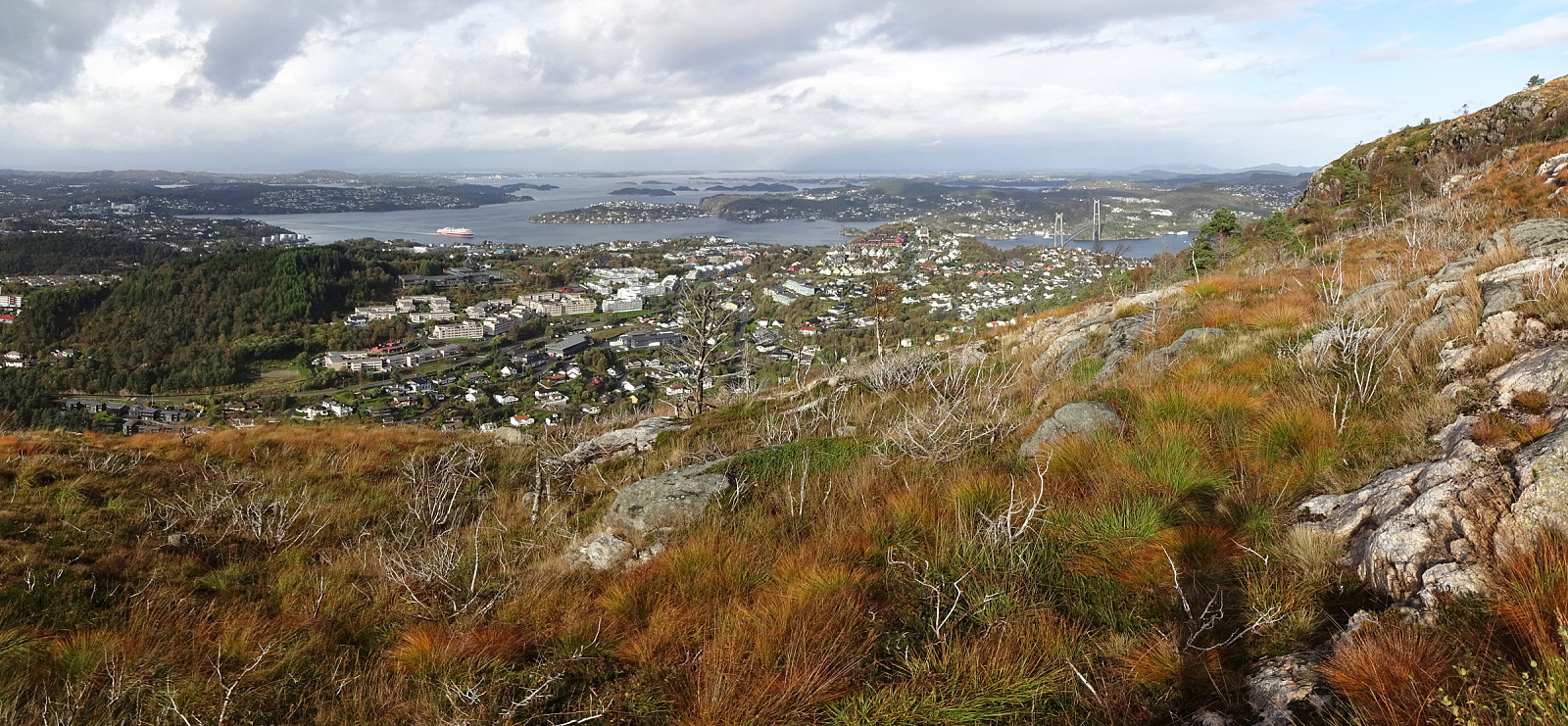
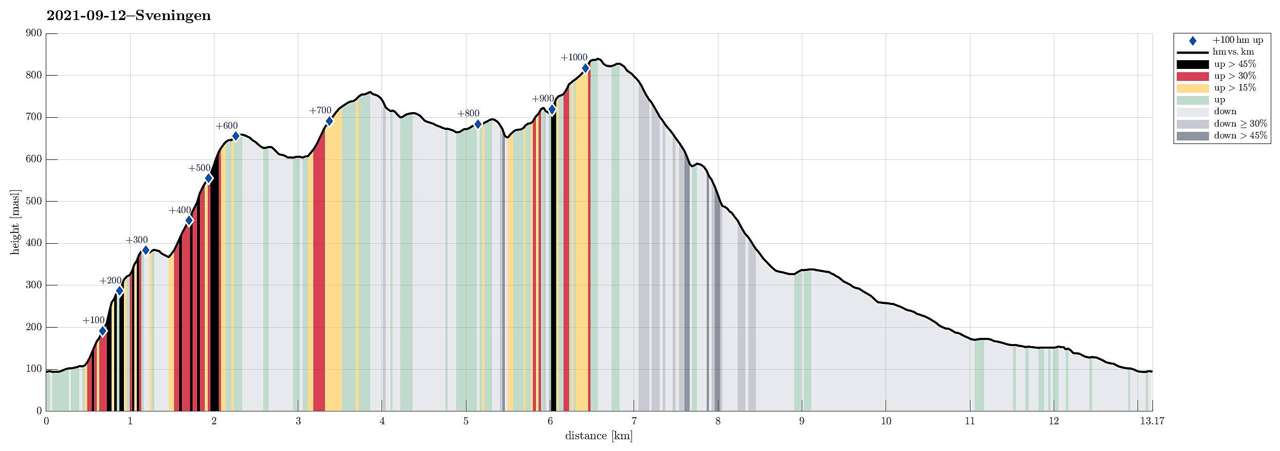
Sveningen via Åsen from Brekkedalen
- Datum:
- 12.09.2021
- Tourcharakter:
- Wanderung
- Tourlänge:
- 6:30h
- Entfernung:
- 13,2km
 The weather forecast has been promising (very promising), even in the morning, so what could go wrong? :-)
Considering the expected day full of sunshine and pleasant hiking temperatures, we aimed at something slightly "bigger" and since we had not visited Sveningen recently, we planned a nice hike over this mountain! To make this a bit more interesting, we decided to include an ascent that we had not tried before (and of which we also could not find any other report from others), i.e., up to Åsen, first, from the north, and then over the northernmost part of the Sveningen massif (in eastwards direction, kind of "parallel" to Brekkedalen in the north of it). To get started, we drove into Hausdalen (from E39, south of Bergen) and all the way into it (until the parking >>>
The weather forecast has been promising (very promising), even in the morning, so what could go wrong? :-)
Considering the expected day full of sunshine and pleasant hiking temperatures, we aimed at something slightly "bigger" and since we had not visited Sveningen recently, we planned a nice hike over this mountain! To make this a bit more interesting, we decided to include an ascent that we had not tried before (and of which we also could not find any other report from others), i.e., up to Åsen, first, from the north, and then over the northernmost part of the Sveningen massif (in eastwards direction, kind of "parallel" to Brekkedalen in the north of it). To get started, we drove into Hausdalen (from E39, south of Bergen) and all the way into it (until the parking >>>
Naknesåta, Austefjellet, and Landåsfjellet
- Datum:
- 04.09.2021
- Tourcharakter:
- Wanderung
- Tourlänge:
- 3:00h
- Entfernung:
- 8,0km
 On my Helldal hike from the previous weekend, I had followed the lowest bit of a trail that appeared to lead further up into the direction of Søre Gløvrevatnet. This time, we wanted to look deeper into this and find out! :-) We drove up Sanddalsringen and parked near the saddle, where Sædalssvingene leaves to the east. From there, we first walked along Helldalslia (almost all the way down to house #45) to connect to a proper trail head. In the last swing of Helldalslia, a path for pedestrians, who wish to connect Helldalslia with Hardangervegen further down in the valley, leaves to the east. We first followed this path a little too long, before going back a few steps and taking the right trail that leads through the forest (slightly upwards in northeastern direction). Once under the power line, >>>
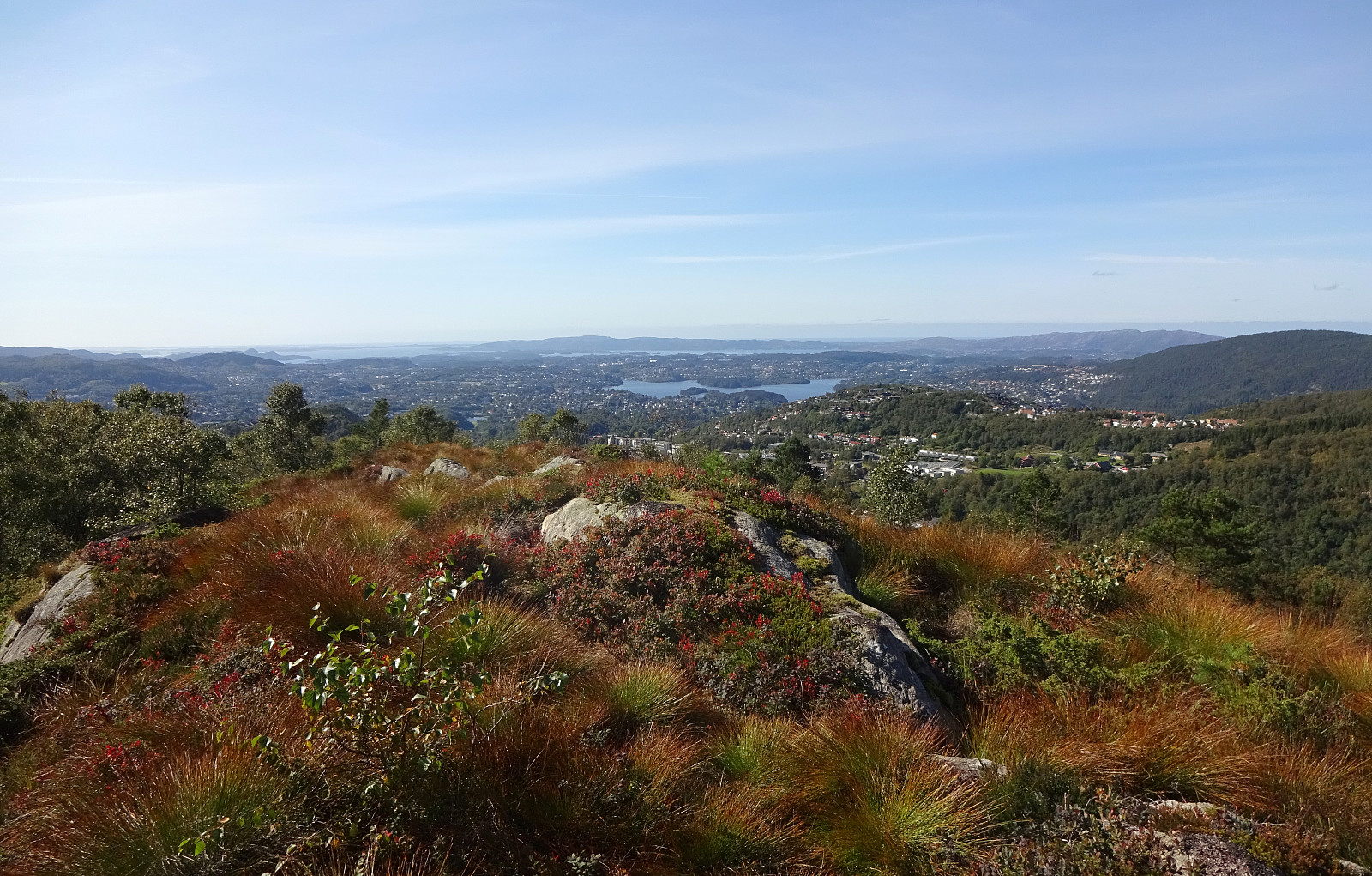
Helldalssåta via Helldal
- Datum:
- 29.08.2021
- Tourcharakter:
- Wanderung
- Tourlänge:
- 3:30h
- Entfernung:
- 11,2km
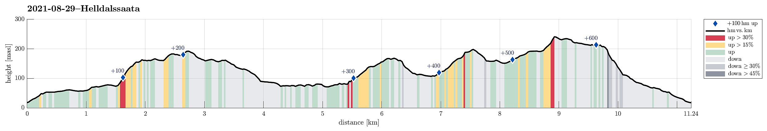 I had taken my bike to Sanddalen (via Nesttun in the south of Bergen) and started my hike in southern direction on Sandbrekkevegen. This brought me across Hardangervegen to Ulsmåg on the other, southern side. My first hiking-goal was to walk across Oksla in the northwest of Dyngeland, following most of its long ridge. Walking up Ulsmågvegen, I watched out for a suitable place, where I could leave the road and start hiking in the terrain. At this southwestern end of the Oksla-ridge, its northwestern face is quite a bit steep, leaving it unclear, while studying the map up-front at home, whether an ascent from this side would be reasonable at all, or whether I would have to go all around to Stallavegen, first. Luckily, I did find a good spot to pass by Ulsmågvegen number 28 (some car rental company there) >>>
