Archiv - Nach Datum
Archiv - Nach Aktivität
-
Andere Tour (1)
- Kayaking (1)
-
Andere Wintertour (4)
- Schneeschuhtour (4)
-
Fahrradtour (123)
- Fahrradtour Straße (5)
- Fahrradtour gemischt (41)
-
Fußtour (736)
- Bergtour (363)
- Jogging (18)
- Spaziergang (88)
- Wanderung (267)
-
Skitour (4)
- Tourenskilauf (4)
Archiv - Nach Geografie
Peakbookfreunde


Gesammelte Listen
-
Bergen ≥ 50m pf. og ≥ 100 m.o.h.
(87/89)
 97%
97% -
Most dominating tops of the Bergen peninsula
(68/75)
90%
-
Utvalgte topper og turmål i Bergen
(313/347)
90%
-
Alle topper i Bergen
(356/398)
89%
-
Opptur Bergen
(100/113)
88%
-
De syv fjell rundt Bergen
(6/7)
85%
-
Sund ≥ 50m pf.
(14/18)
77%
-
Os ≥ 50m pf.
(25/34)
73%
-
Søyler (fastmerker) i Bergen
(68/100)
68%
-
Fjell ≥ 50m pf.
(21/32)
65%

An attempt to Slettefjellet via Eikemostølen
- Datum:
- 20.07.2022
- Tourcharakter:
- Wanderung
- Tourlänge:
- 2:00h
- Entfernung:
- 4,4km
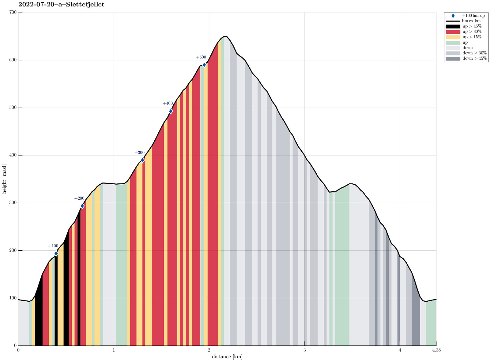 The weather forecast was not really promising, but we decided to still give it a chance. Driving down Eksingedalen and passing by the tunnel to Modalen, we soon came to Treshaugen near Eikemo, where we parked the car right next to the road. We had read up front that we should be able to locate a (steep) trail up to Eikemostølen from there and indeed we could find some blue marks on a couple of trees right next to the road near the northern bend of Ekso (in the northeast of Eikemo). Still, finding the "trail" did then require a lot of imagination (yes, a good number of trees were marked on the way up to Eikemostølen, but the "trail" was hard to see, or not, and partially covered fully with vegetation like high grass or farns). Nonetheless, it was then without major >>>
Saudalsnovi from Flatekvål in Eksingedalen
- Datum:
- 19.07.2022
- Tourcharakter:
- Wanderung
- Tourlänge:
- 6:00h
- Entfernung:
- 16,4km
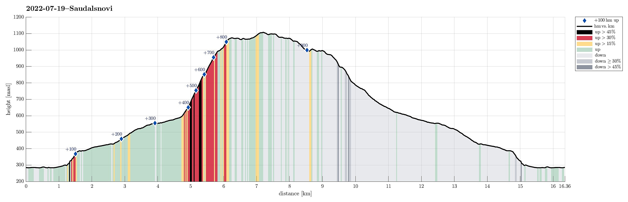 Expecting a nice day, we aimed at Saudalsnovi in the southwest of Lavik in Eksingedalen. We drove to Flatekvål, a short stretch down Eksingedalen from Lavik, and parked at the parking place for the church, Eksingedalen Kyrkje, right next to Eksingedalsvegen. From there, we walked along Sørdalsvegen, passing by the church and crossing over river Ekso close to where Sørdalen comes down on the other, southern side. After crossing the flat spot at Øyna and entering Sørdalen, we came to a few (commercial?) buildings. There, on the back-side of these buildings, we found a simple pedestrians' bridge that lead us over to the other, western side of the Sørdalselvi. There, we quickly found a marked trail that would lead us (steeply) up to the ridge above Furneslii. Once up there, at about >>>
Det Høga Bungane from Haugen
- Datum:
- 18.07.2022
- Tourcharakter:
- Wanderung
- Tourlänge:
- 2:00h
- Entfernung:
- 6,5km
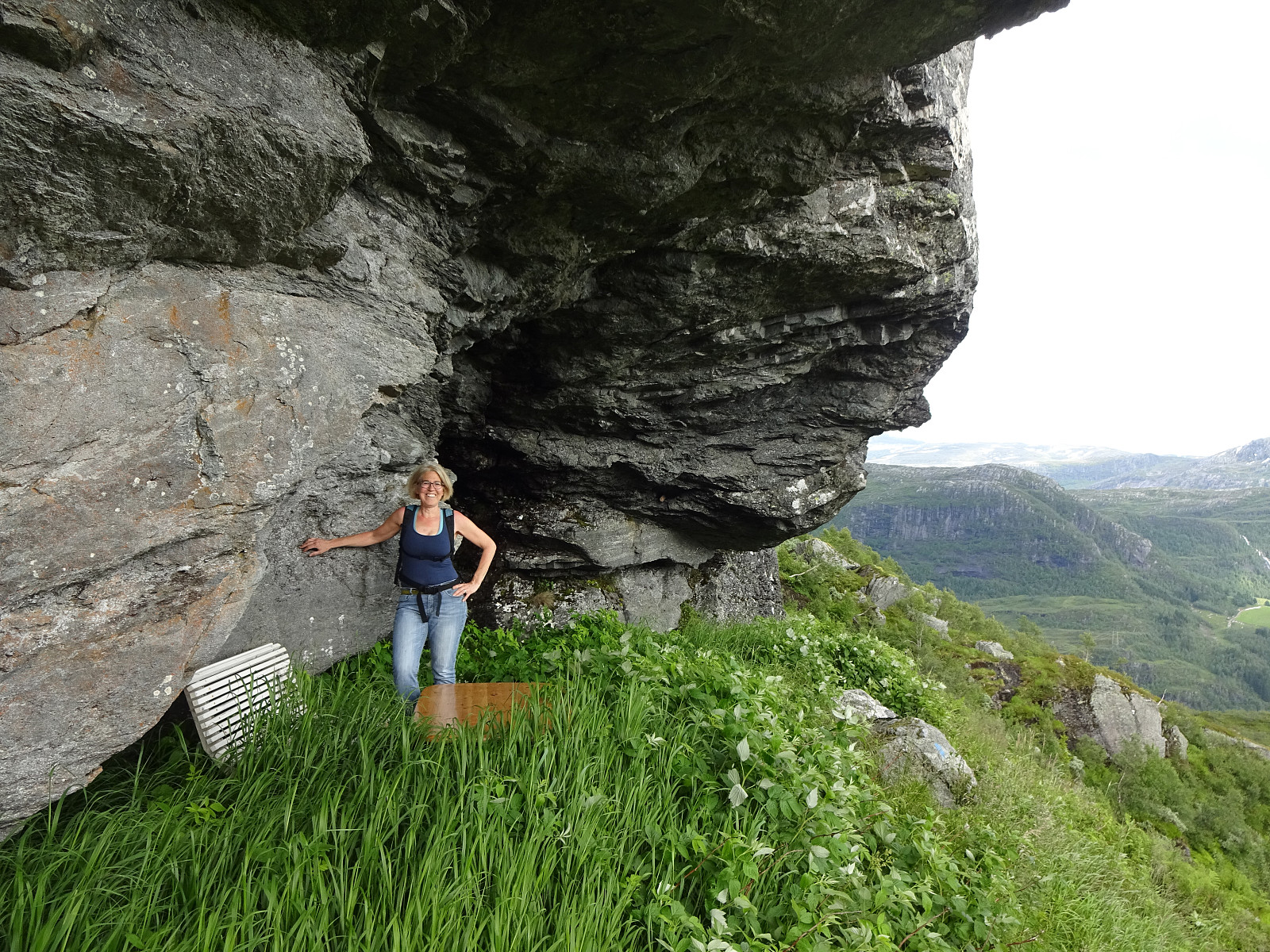 After some driving, we ended up in Lavik, Eksingedalen, in the early evening. We decided that it was still enough time for a short walk and followed a recommendation from one we had talked to in Lavik, driving up to Haugen in Fagerdalen, just northeast of Lavik. From there, we started walking, reaching Lavikstølen at the end of the gravel road leading up there from Haugen. At Lavikstølen, we still wished to include a bit more and so we continued along a trail that leads upwards (in western direction) from Lavikstølen. First, we thought that this trail would lead up to Nipa, just to find out rather quickly that the trail tended more and more into southwestern direction, instead. Once above 700mosl, it became clear that this trail would lead around some pronounced cliffs in the south >>>
Søtefjellet from Hausdalen via Åsen
- Datum:
- 25.06.2022
- Tourcharakter:
- Wanderung
- Tourlänge:
- 4:00h
- Entfernung:
- 10,4km
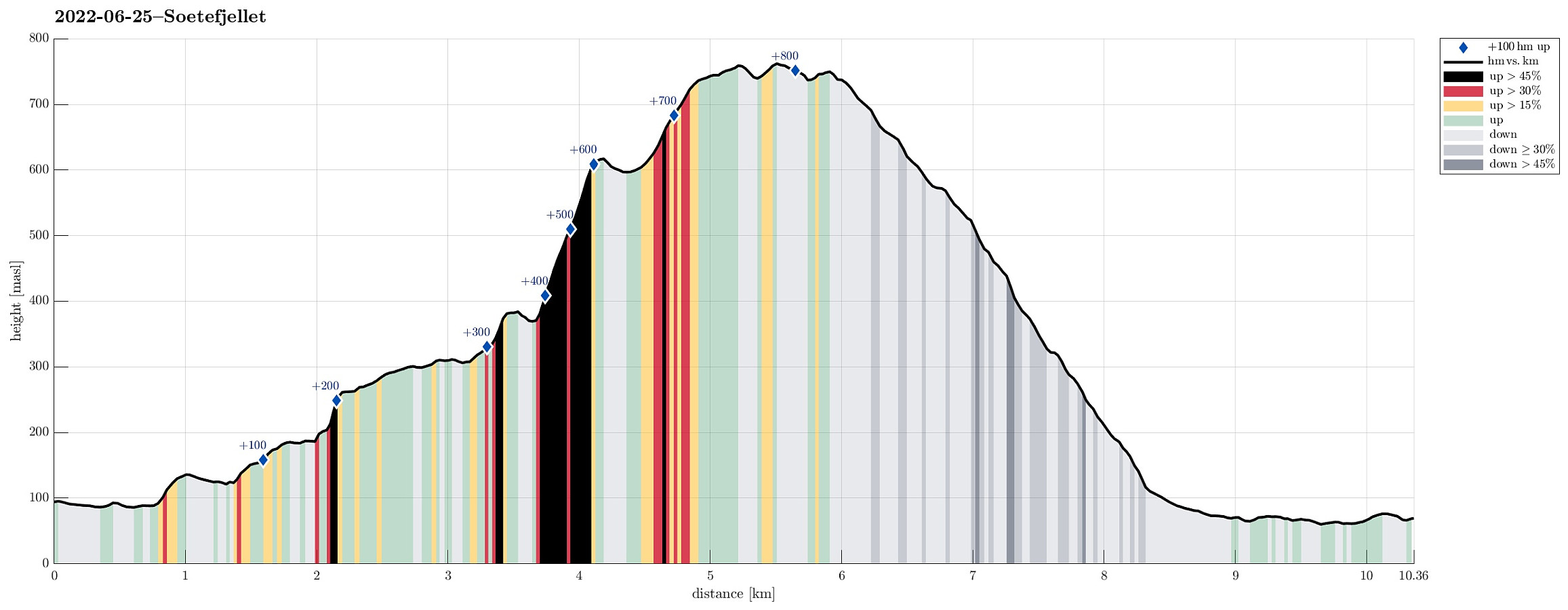 We exploited the situation of having two cars to cut short a few kilometers on the road through Samdalen. After passing by Kalandsvatnet along E39 in the south of Bergen, we turned left at Kalandseidet to continue further into Hausdalen. Right before coming to Tømmervika of Samdalsvatnet, we left one car where a forest road comes down to Hausdalsvegen. With the other car, we then continued all the way in to the end of Hausdalsvegen, where we parked at the parking spot. Given our plan to ascend Søtefjellet via Åsen, we had planned to cross Hausdalselva using a simple bridge at Hausdalen, just a few meters back along the "main road". Getting there, however, we found a sign that informed us that crossing over there was only possible with the consent of the land owner. Luckily, >>>
Høgafjellet (and Hikletten) from Lonadalen
- Datum:
- 05.06.2022
- Tourcharakter:
- Wanderung
- Tourlänge:
- 5:30h
- Entfernung:
- 17,7km
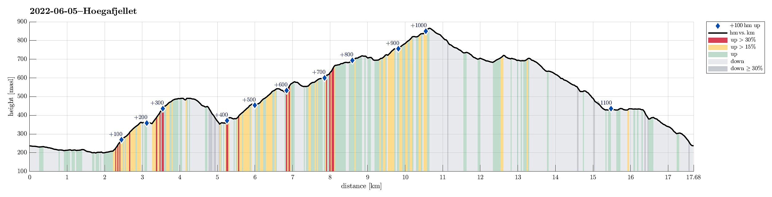 Very nice round including Høgafjellet on Osterøy, starting from its south, i.e., Lonadalen. Using Osterøybrua to conveniently cross over to Osterøy, we turn right before entering the tunnel, driving to Bruvik from there. Leaving the fjord there, we ascended to the saddle in the north of Bruvik (and in the east of Brøknipa) to connect to the interior of Osterøy along road 5418. Before getting all the way down to the large lakes in the middle of Osterøy, we turned right, entering a gravel road that would bring us to Lonadalen, passing by Sagatjørna, Midtvatnet, and Blomdalsvatnet. Near the saddle in Lonadalen, where also the trail from Høgafjellet comes down, we parked and started our hike in northeastern direction, following Lonadalen a bit further, first. At Midttun, we passed >>>
Kanadaskogen from Varden
- Datum:
- 28.05.2022
- Tourcharakter:
- Wanderung
- Tourlänge:
- 1:30h
- Entfernung:
- 4,6km
 Walk through Kanadaskogen from Varden, including Hesjaholten. After first passing by Gjeddevatnet at Skaget, we crossed over some minor hills in northern direction, coming close to Bjørndalsvatnet (but not descending all the way down to it, this time). North of Hesjaholten, we then ascended to one of the small cliffs using a narrow gully in southwards direction. We then included also a neighboring cliff (a little further towards the northeast), before heading back into the direction of Varden, including Hesjaholten along the way. It's definitely possible to experience small but nice micro-adventures in Kanadaskogen! :-)
Selected photos are available as Google photo album .
See also the related FB-page Hiking around Bergen, Norway .
Walk through Kanadaskogen from Varden, including Hesjaholten. After first passing by Gjeddevatnet at Skaget, we crossed over some minor hills in northern direction, coming close to Bjørndalsvatnet (but not descending all the way down to it, this time). North of Hesjaholten, we then ascended to one of the small cliffs using a narrow gully in southwards direction. We then included also a neighboring cliff (a little further towards the northeast), before heading back into the direction of Varden, including Hesjaholten along the way. It's definitely possible to experience small but nice micro-adventures in Kanadaskogen! :-)
Selected photos are available as Google photo album .
See also the related FB-page Hiking around Bergen, Norway .
Rødsfjellet via Kråkedalen
- Datum:
- 17.05.2022
- Tourcharakter:
- Wanderung
- Tourlänge:
- 3:00h
- Entfernung:
- 8,8km
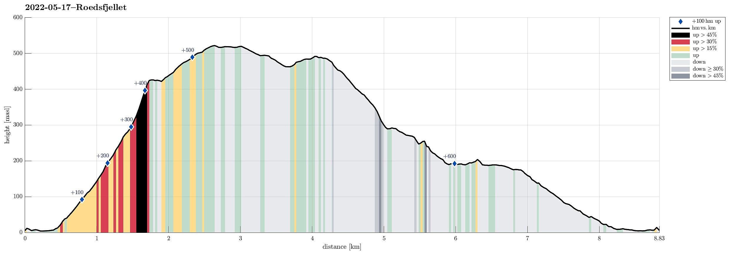 Rødsfjellet from the north/northeast. We drove via Osøyro to connect to Hegglandsdalvegen, which we followed to the small bay in the northeast of Rødsfjellet, where Øvredalsvegen forks off to the north. We parked right there and started our hike with a short walk along Ovredalsvegen until we came to the farm at the lowest end of Kråkedalen. Following first a forest road into Kråkedalen, we started our ascent to Rødsfjellet. Walking up Kråkedalen was straight-forward and easy and soon we had reached the of the forest road in the southeast of Halvardsåsen. There, at about 250mosl, we then deviated from the main valley and headed up and out of the main valley in southeastern direction. Finding a suitable side-valley for this purpose, we managed to reach the northern ridge of Rødsfjellet >>>
Skavlandsfjellet from Søyleplasset and Totlandsfjellet
- Datum:
- 15.05.2022
- Tourcharakter:
- Wanderung
- Tourlänge:
- 4:00h
- Entfernung:
- 11,4km
 Ascending to Brattlandsfjellet from Brattland -- a long time plan! :-) We parked in the south of Søylevatnet, where the trail from Furedalen comes down from the south. After walking around Søyleplasset along the main road, we started our ascent to Dansebakken in the southwest of Søylevatnet. While we first were quite a bit unsure regarding how challenging this ascent would be, we then found out that a nice, minor trail actually leads up via Dansebakken! :-) Steadily ascending further upwards, we arrived at Skavdalsfjellet without any difficulties. We then crossed over Skavdalsfjellet, without including Flåfjellet further in the west, surrounding Fjellklovevatnet in its east. We then descended into Furedalen via the eastern hillside of Stordalsfjellet. There, we crossed the stream >>>
Up Lyderhorn and further to Fyllingsdalen
- Datum:
- 24.04.2022
- Tourcharakter:
- Wanderung
- Tourlänge:
- 2:30h
- Entfernung:
- 8,2km
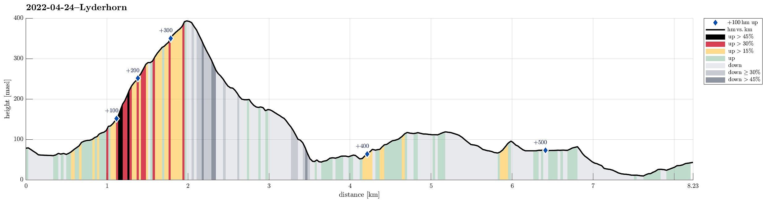 Hiking Lyderhorn and walking back to Fyllingsdalen from there. We took a bus via Loddefjord that was heading towards Olsvik, getting off where Olsvikskjenet is connected to Gamle Kjøkkelvikveien. Walking down there, we could easily connect to Lyderhornslien on the other, eastern side. From there, we then ascended to Lyderhorn following a minor trail that leads up a little further north than the main trail from Kjøkkelvik. Once on Lyderhorn, we continued in southern direction down again (into the direction of Skarpafjellet). When reaching the saddle right north of Skarpafjellet, we turned left and descended to the main highway-cross in the southeast of Lyderhorn. On the other side, we then walked up to Tennebekktjørna and further over to Spelhaugen. All in all, a nice hike connecting >>>
Liatårnet and Haganesfjellet from Liaskjeret
- Datum:
- 23.04.2022
- Tourcharakter:
- Wanderung
- Tourlänge:
- 3:30h
- Entfernung:
- 8,8km
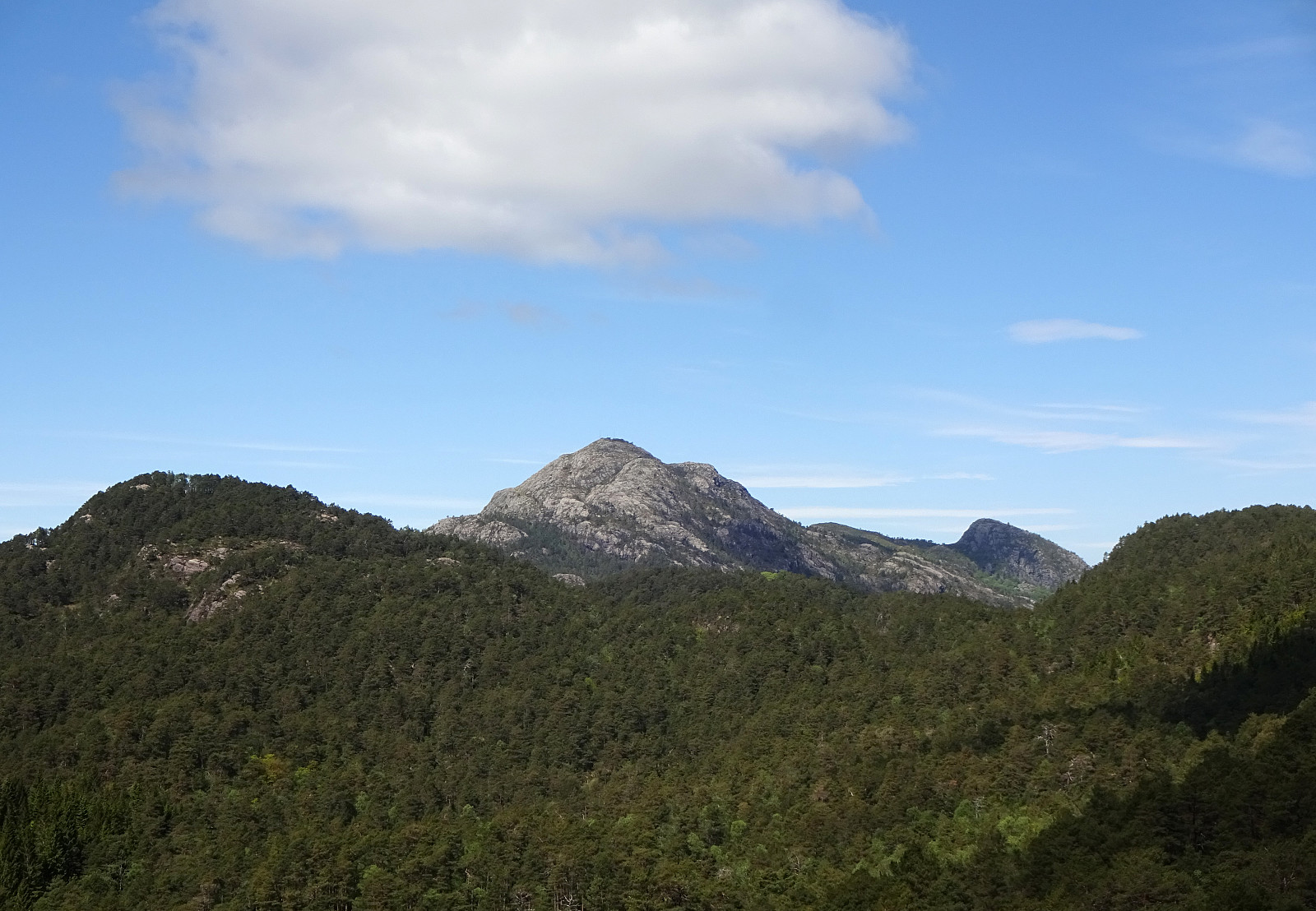
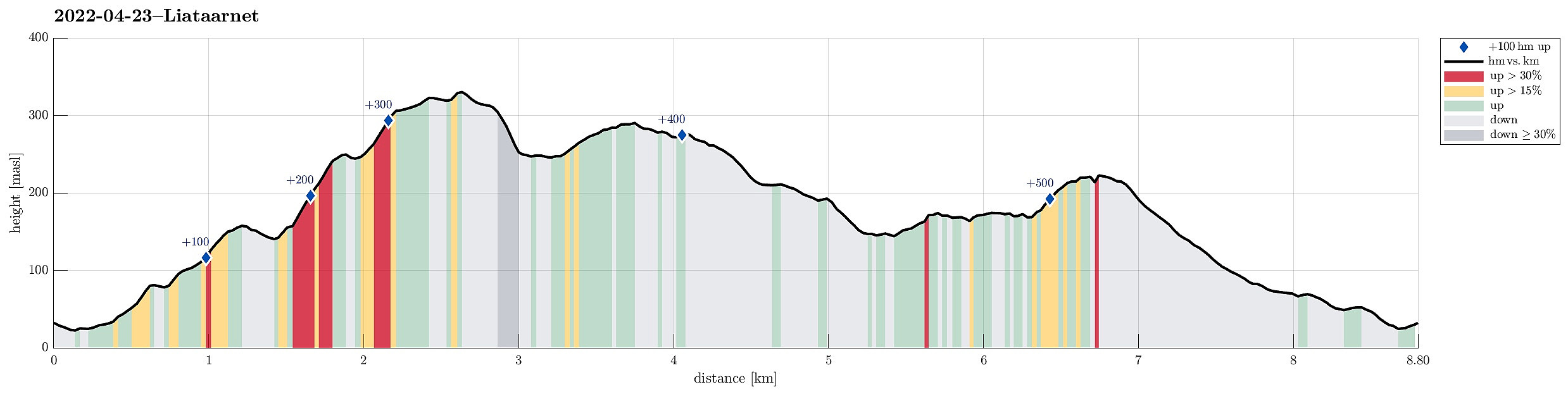 Liatårnet and Haganesfjellet from Liaskjeret. We parked next to Liaskjershallen in the southeast of Liatårnet on Sotra and walked first back (northwards) along Liaskjervegen until we found the spot where one can ascend to Dansarhaugen (just a few steps above the last houses on the hillside up to Liatårnet). We then crossed Skoradalen, mostly in northern direction, before we changed course after crossing over Bukkhelleren into a more northwestern direction, ascending rather straight up towards Liatårnet. Once on Liatårnet, we started our traverse across the heights south of Liatårnet, mostly in southern direction. South of Høgafjellet, we then came to Kattatjørna. This time, we passed by this lake on its eastern side, also stepping over Kattafjellet. It then was just straight southwards, >>>
