Archiv - Nach Datum
Archiv - Nach Aktivität
-
Andere Tour (1)
- Kayaking (1)
-
Andere Wintertour (4)
- Schneeschuhtour (4)
-
Fahrradtour (137)
- Fahrradtour Straße (9)
- Fahrradtour gemischt (51)
-
Fußtour (740)
- Bergtour (363)
- Jogging (18)
- Spaziergang (89)
- Wanderung (270)
-
Skitour (4)
- Tourenskilauf (4)
Archiv - Nach Geografie
Peakbookfreunde


Gesammelte Listen
-
Bergen ≥ 50m pf. og ≥ 100 m.o.h.
(87/89)
 97%
97% -
Most dominating tops of the Bergen peninsula
(68/75)
90%
-
Utvalgte topper og turmål i Bergen
(316/350)
90%
-
Alle topper i Bergen
(357/398)
89%
-
Opptur Bergen
(100/113)
88%
-
De syv fjell rundt Bergen
(6/7)
85%
-
Sund ≥ 50m pf.
(14/18)
77%
-
Os ≥ 50m pf.
(25/34)
73%
-
Søyler (fastmerker) i Bergen
(68/100)
68%
-
Fjell ≥ 50m pf.
(21/32)
65%

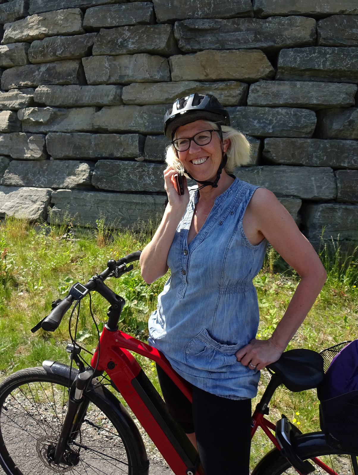
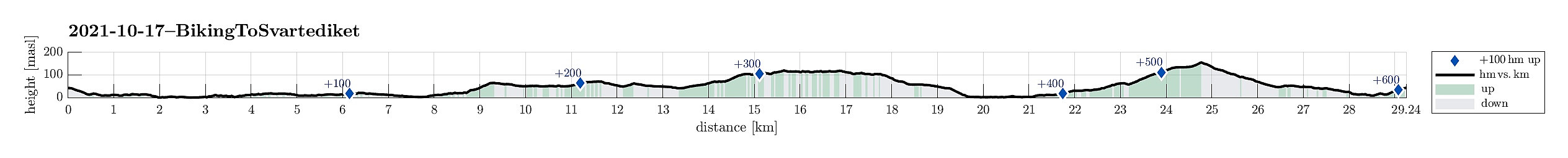
Biking to and from Krambua
- Datum:
- 08.10.2023
- Tourcharakter:
- Fahrradtour
- Tourlänge:
- 1:30h
- Entfernung:
- 17,6km
 We started with the assumption that there was a joint hike agreed upon, starting from Krambua. After refilling some air, we biked along Sælevatnet and Nordåsvatnet to Krambua (just to find out that, yes, there was an agreement to hike, but not for this Sunday! :-)). We thus took our bikes back home, including a bit of a detour (first up through Langeskogen, then via Bønes to Fyllingsdalen). Altogether a nice bike-ride in nice weather! :-)
See also the related FB-page Hiking around Bergen, Norway .
We started with the assumption that there was a joint hike agreed upon, starting from Krambua. After refilling some air, we biked along Sælevatnet and Nordåsvatnet to Krambua (just to find out that, yes, there was an agreement to hike, but not for this Sunday! :-)). We thus took our bikes back home, including a bit of a detour (first up through Langeskogen, then via Bønes to Fyllingsdalen). Altogether a nice bike-ride in nice weather! :-)
See also the related FB-page Hiking around Bergen, Norway .
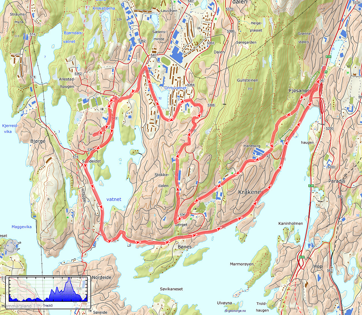
Biking detour in Fyllingsdalen
- Datum:
- 16.09.2023
- Tourcharakter:
- Fahrradtour
- Tourlänge:
- 1:00h
- Entfernung:
- 12,1km
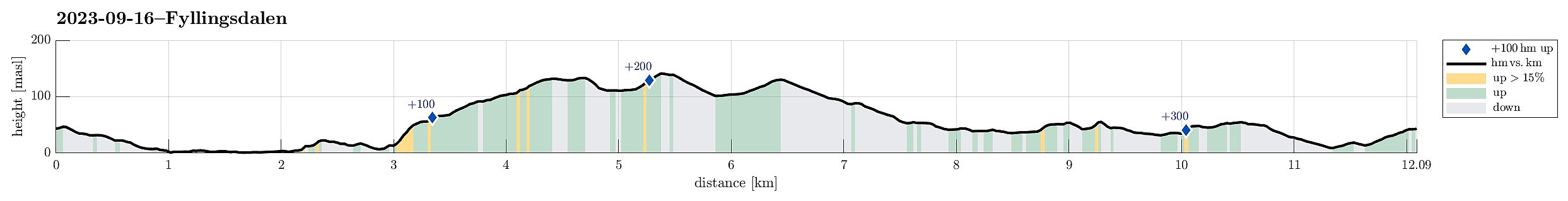 While en route to a local supermarket for some shopping, I decided to bike a little detour. First, I surrounded Sælevatnet in its south. I then took the steep way up to Bønes/Fjellsdalen. I then cycled around Lyshovden in its northeast. After passing by Oasen, I decided to make a brief exploration of Skulehaugen -- kind of strange to passing by this little hill (almost) every day, but never actually making it up to its "top". After that, it was mostly to the shop and then back home -- so not so much to write, today...
See also the related FB-page Hiking around Bergen, Norway .
While en route to a local supermarket for some shopping, I decided to bike a little detour. First, I surrounded Sælevatnet in its south. I then took the steep way up to Bønes/Fjellsdalen. I then cycled around Lyshovden in its northeast. After passing by Oasen, I decided to make a brief exploration of Skulehaugen -- kind of strange to passing by this little hill (almost) every day, but never actually making it up to its "top". After that, it was mostly to the shop and then back home -- so not so much to write, today...
See also the related FB-page Hiking around Bergen, Norway .
Accidental Stemhaugen
- Datum:
- 26.08.2023
- Tourcharakter:
- Fahrradtour gemischt
- Tourlänge:
- 2:00h
- Entfernung:
- 20,2km
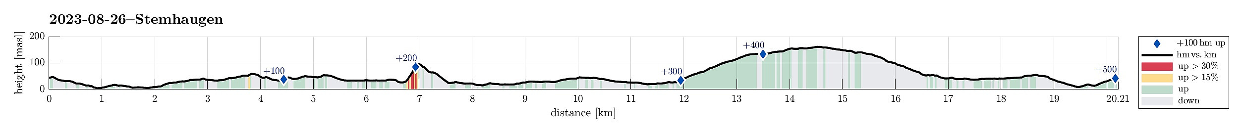 The primary goal of this trip was to just do a bit of shopping! :-) Once on my bike, however, I immediately thought that making a short detour, first, would be good. I thus started along Bjørgeveien and headed northwards towards Bjørndalen. South / southeast of Lyderhorn, I then connected to Liavatnet. As I came towards the northern end of Liavatnet, I thought that this was maybe my chance to include a short visit to Stemhaugen! :-) North of the dam that holds back Liavatnet, I thus left my bike behind and found my way (rather "way") up to Stemhaugen via its northern ridge (no trail, steep, but not difficult). I then crossed over the top of Stemhaugen, enjoying some nice views down to Liavatnet and over to Lyderhorn. On my way down (still in southern direction), I made it >>>
Bike-hiking Skavdalsfjellet (and some additional hills)
- Datum:
- 23.07.2023
- Tourcharakter:
- Fahrradtour gemischt
- Tourlänge:
- 6:00h
- Entfernung:
- 43,6km
 Due to some unfortunate illness, this excursion was without the usual company. The idea was to first ride my eBike to a suitable starting point and then do a hike from there. Also, I thought to make a hike, which we quite likely would not do together (parts of the planned hike were predicted to be more like a bush war than anything else*), ending up at the area in the northeast of Myrdalsvatnet with its smaller (and honestly speaking also not terribly exciting) hills (Kattuglehaugane, Barkahaugane, Kattuglefjellet, and Preståsen). I also thought to visit two small hills in Skjold (Skjoldhøgda and Storåsen), since they were along my route to Myrdalsvatnet (and since I thought that I'd never visit them otherwise anyway).
Biking around Søråsen, I made my way to Skjold. Finding a good route >>>
Due to some unfortunate illness, this excursion was without the usual company. The idea was to first ride my eBike to a suitable starting point and then do a hike from there. Also, I thought to make a hike, which we quite likely would not do together (parts of the planned hike were predicted to be more like a bush war than anything else*), ending up at the area in the northeast of Myrdalsvatnet with its smaller (and honestly speaking also not terribly exciting) hills (Kattuglehaugane, Barkahaugane, Kattuglefjellet, and Preståsen). I also thought to visit two small hills in Skjold (Skjoldhøgda and Storåsen), since they were along my route to Myrdalsvatnet (and since I thought that I'd never visit them otherwise anyway).
Biking around Søråsen, I made my way to Skjold. Finding a good route >>>
Biking around Hordnesskogen
- Datum:
- 17.06.2023
- Tourcharakter:
- Fahrradtour gemischt
- Tourlänge:
- 2:00h
- Entfernung:
- 31,8km
 With also the other bike repaired, we headed for a new biking-round around Nordåsvatnet. Again, we started our joint ride near the light rail station at Kristianborg, heading south (into the direction of Nesttun). This time, we surrounded Kristianborgvannet on the other, eastern side, though. Following the main bike route southwards, we eventually ended up in Rådalen. There, we decided that we would bike around Hordnesskogen in its south. Afte first following Rådalen further south (to the north of the school at Stend), we then turned right and onto Hordesvegen. Near house #202 along Hordnesvegen, we then came to a parking opportunity for those, who wish to start into Hordnesskogen from the south there. There, we headed into Hordnesskogen (in northwestern direction) for a few hundred >>>
Biking around Nordåsvatnet
- Datum:
- 03.06.2023
- Tourcharakter:
- Fahrradtour gemischt
- Tourlänge:
- 2:00h
- Entfernung:
- 25,0km
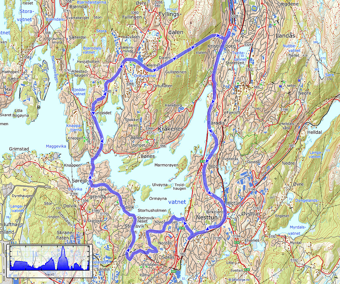 We had a bike to pick up and wished to ride a little round -- not at the least to also see that it was functioning as well as expected. We started the joint ride at the bike shop near the light rail station at Kristianborg, heading first southwards along Kanalveien and then following the track of the no longer existing railway into the direction of Nesttun. At the church of Skjold, we then turned right and cycled down to Skjoldbukta along Harald Skjolds veg. From there, we then cycled up to Nordåsvegen, which we then followed "all around" Nordåsen. On the south, we then descended to Steinsvikvegen. Following Steinsvikvegen around Steinsviken and Søviken, we connected to Søreide and from there further northwards to Sandeidet. All in all, a nice bike ride! :-)
See also the >>>
We had a bike to pick up and wished to ride a little round -- not at the least to also see that it was functioning as well as expected. We started the joint ride at the bike shop near the light rail station at Kristianborg, heading first southwards along Kanalveien and then following the track of the no longer existing railway into the direction of Nesttun. At the church of Skjold, we then turned right and cycled down to Skjoldbukta along Harald Skjolds veg. From there, we then cycled up to Nordåsvegen, which we then followed "all around" Nordåsen. On the south, we then descended to Steinsvikvegen. Following Steinsvikvegen around Steinsviken and Søviken, we connected to Søreide and from there further northwards to Sandeidet. All in all, a nice bike ride! :-)
See also the >>>
Biking Grimseidvegen (with Storrinden and Stendafjellet)
- Datum:
- 05.02.2023
- Tourcharakter:
- Fahrradtour
- Tourlänge:
- 2:30h
- Entfernung:
- 35,6km
 This time, we were in the mood for a bike trip. We headed first south, passing by Sælenvatnet in its southwest, before then crossing over the narrow connection of Nordåsvatnet and Grimstadfjorden. While heading further southwards, we included a detour up to Storrinden (this was quite interesting as substantial sections of the road up and down were covered with ice). Once back on Ytrebygdsvegen, we continued further southwards. We crossed Flypassvegen and continued into the direction of Hjellestad. Before actually getting there, however, we turned left (twice) to get onto Grimseidvegen. This way, we had changed direction and were cycling in about eastern/northeastern direction. Once passed Grimseidvatnet, we turned right to get onto Skeievegen that brought us to the other side of Hordnesskogen >>>
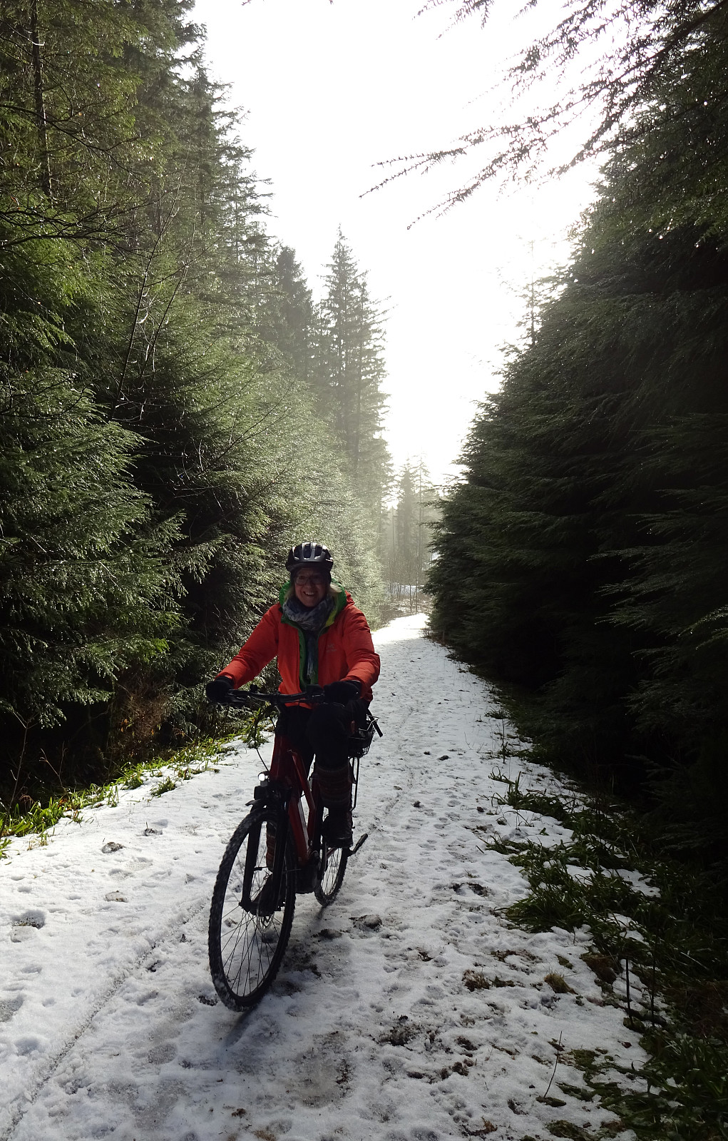
Double-round to Alvøen
- Datum:
- 28.11.2021
- Tourcharakter:
- Fahrradtour gemischt
- Tourlänge:
- 3:00h
- Entfernung:
- 28,8km
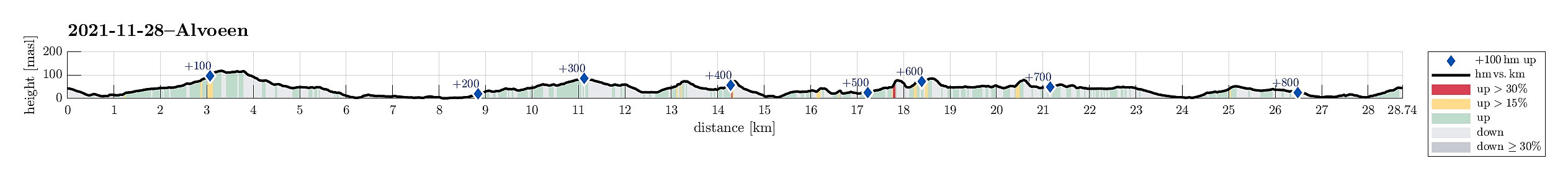 Even though I had a lot of work to do, still, I could not resist the nice weather and needed to get out, at least a little! Getting onto my eBike, I decided to visit Alvøen (once again) and check out a few of the smaller hills there. To get there, I decided to pass by Tennebekk, first. I thus biked first north in Fyllingsdalen and at Spelhaugen I got onto the gravel road that leads up to Tennebekk. On the other side, I turned south (southwest), again. Passing by Loddefjord, I aimed at Hilleren in the southwest of Haakonsvern. Once past Mathopen, I connected to Skarelien, which brought me up to Hilrafjellet by basically cycling a "full round" around it, first. From Hilrafjellet, I enjoyed some proper views, before I continued to check out Medhaugen next. While I could also >>>
Ørnafjellet (and Lyderhorn) the "wild" way
- Datum:
- 14.11.2021
- Tourcharakter:
- Fahrradtour gemischt
- Tourlänge:
- 3:00h
- Entfernung:
- 17,6km
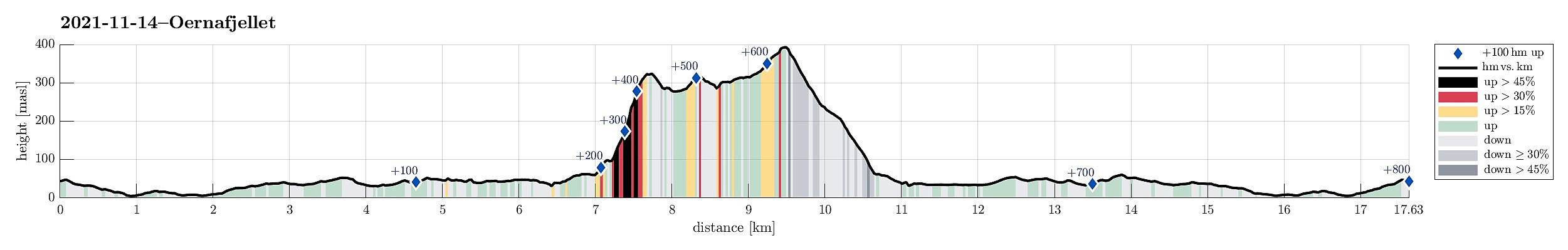 After a very nice "standard" hike to Møsnuken the day before, we wished to use the second nice weekend day for another, maybe a bit more "experimental" hike. For some time already, we had asked ourselves, whether it is possible to ascend Ørnafjellet near Lyderhorn "direttissima" from Banuren. This Sunday, we thought to try this idea. We took our eBikes and biked along Bjørgeveien into the direction of Loddefjord. After rounding Svartaberget and Bjørndalstjørna, we cycled northwards on the eastside of Lyderhorn, passing by Liavatnet. On the northeastern side of Lianakken, we turned left and onto Banuren, leading us up to the houses of Banuren. Between Søre Banuren and Nordre Banuren, where one major trail from Lyderhorn comes down, we left our bikes behind, starting >>>
Approaching Ulriken from Fyllingsdalen
- Datum:
- 17.10.2021
- Tourcharakter:
- Fahrradtour
- Tourlänge:
- 2:00h
- Entfernung:
- 29,3km
 With a nice Sunday ahead of us, we decided to approach our hike by bike (eBike). Starting from Varden in Fyllingsdalen, we first biked around Bønes (along Nordåsvatnet) towards Fjøsanger. From there, we connected to the heights in the south of Storetveit kirke. Following Storetveitvegen, Hagerups vei (around Tveitevannet), and then Birkeveien, we made it to Haukelandsveien, which we followed to the northern side of th hospital. From Årstadveien we then biked along Stemmeveien and Lappen to Tarlebøveien. To focus our hike on higher grounds, we then cycled a little further along Svartediket, before we then left our bikes behind for a nice hike over Vidden . Once back from this hike, we then took the bikes out, again. To get back to Fyllingsdalen, we then chose to take the route via Melkeplassen, biking first along >>>
