Archiv - Nach Datum
Archiv - Nach Aktivität
-
Andere Tour (1)
- Kayaking (1)
-
Andere Wintertour (4)
- Schneeschuhtour (4)
-
Fahrradtour (123)
- Fahrradtour Straße (5)
- Fahrradtour gemischt (41)
-
Fußtour (736)
- Bergtour (363)
- Jogging (18)
- Spaziergang (88)
- Wanderung (267)
-
Skitour (4)
- Tourenskilauf (4)
Archiv - Nach Geografie
Peakbookfreunde


Gesammelte Listen
-
Bergen ≥ 50m pf. og ≥ 100 m.o.h.
(87/89)
 97%
97% -
Most dominating tops of the Bergen peninsula
(68/75)
90%
-
Utvalgte topper og turmål i Bergen
(313/347)
90%
-
Alle topper i Bergen
(356/398)
89%
-
Opptur Bergen
(100/113)
88%
-
De syv fjell rundt Bergen
(6/7)
85%
-
Sund ≥ 50m pf.
(14/18)
77%
-
Os ≥ 50m pf.
(25/34)
73%
-
Søyler (fastmerker) i Bergen
(68/100)
68%
-
Fjell ≥ 50m pf.
(21/32)
65%

Algrøyna, Smalaneset
- Datum:
- 03.09.2016
- Tourcharakter:
- Bergtour
- Tourlänge:
- 2:30h
- Entfernung:
- 4,5km
 We drove westwards from Bergen towards the outer islands and stopped at Algrøyna (basically at the very last bus stop, there). From there, we continued into western direction, looking into Nøtevika, first. We then crossed over to the relatively large peninsula of Algrøyna, which lies between Breivika in the north and Kungvika in the south. We followed a well-marked path westwards as soon as we had reached this peninsula, following the northern coastline. Relatively quickly, we proceeded towards the outermost tip of this peninsula, Smalaneset, enjoying many great views already on the way out there. After a short rest, we returned---this time following the southern shore, along Kungvika. Back to the street (Kungvikvegen), we did not have long to go, before we were back to the car. It's >>>
Gåssand
- Datum:
- 27.08.2016
- Tourcharakter:
- Bergtour
- Tourlänge:
- 1:30h
- Entfernung:
- 3,7km
 We used E39 towards Os from Bergen, taking a small road, Gåssandvegen, to the left, right before Søfteland. We then followed this narrow road to Hatlelia, where the road is taking a sharp turn to the right, crossing Nordelva there and then leading back to a farm that lies near Gåssandvatnet (where Sagelva comes down). We parked near to the lake and started to hike from there, following a forrest road that parallels Sagelva. After only a few steps, this forrest road passes Os El-verk, before it becomes a litte more steep. Eventually, we came over a small saddle with Krokvatnet right beneath us. We followed the pretty new road down to the dam, which holds back Krokvatnet, just to learn that there was no way to cross over the dam as we had planned. The southeastern side of this dam is >>>
Høgafjellet
- Datum:
- 21.08.2016
- Tourcharakter:
- Bergtour
- Tourlänge:
- 5:45h
- Entfernung:
- 15,2km
 We took the car to Osterøy and there to Tysso, where we followed a narrow road up to Osvatnet, parking at the end of this road, right next to the power station house. We knew already that the old route via the many wooden stairs right next to the water pipe that leads down to the power station house was closed and we followed the alternative route, which first leads into the valley of Kupelva, right underneath Preikestolen. All the efforts that were made to make this track welcoming and easy to go are highly appreciated! Near some moor, right underneath Preikestolen, the path splits and the ones, who wish to ascend towards Høgafjellet, take the path to the right, turning southwards. Via some stairs that help through a small, narrow valley, one gets up to the level of Nedra Botnavatnet. >>>
Bergen-Løvstakken-Fyllingsdalen
- Datum:
- 19.08.2016
- Tourcharakter:
- Bergtour
- Tourlänge:
- 3:00h
- Entfernung:
- 9,0km
 Friday, afternoon, and nice weather in Bergen---why not walking home via Løvstakken?! :-) To Puddefjordsbroen, first, then over the bridge (on the southeastern side to optimize the connection on the other side). Using the pedestrians path, bridge, and tunnel one connects to Gyldenprisveien and from there, right above where Løvstakktunnelen has its northern end, further to Frydenbølien (upwards to the west, after crossing over the tunnel). Right where Frydenbølien makes a sharp turn to the left, a simple path leads into the hillside behind the buildings. Ascending in southern direction brings one close to the new Løvstien (in particular, when one heads a bit more to the left/east, while ascending). At the upper end of this little valley, near to where Løvstien connects to Riplegården >>>
Liafjellet from Moberg
- Datum:
- 14.08.2016
- Tourcharakter:
- Bergtour
- Tourlänge:
- 2:00h
- Entfernung:
- 4,9km
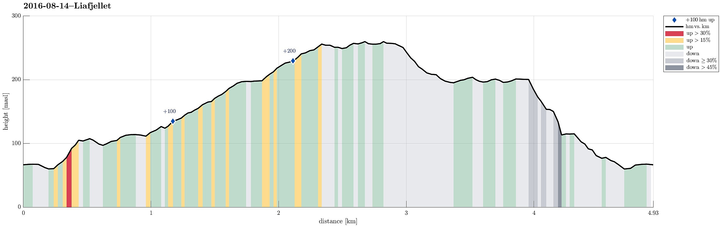 South of Bergen, we crossed Ulvenvatnet near Os on the E39 and drove off it near Os Brannstasjonen in Moberg, right after coming through Liafjellstunnelen. We parked right next to the firestation and started to walk from there. Due to some construction work there, we could not use Halhjemsvegen, where it meets Mobergsbakken. Following a substitution path (leaving Mobergsbakken between Halhjemsvegen and Olavegen), we surrounded the construction site and connected to Liafjellstunnelen. When coming there, right in the beginning of this hike, we did not understand that crossing the E39 first on the lower gravel road (and turning left doing so) leads one to another forrest road that brings one back to the top of Liafjellstunnelen. We therefore ascended Liafjellstunnelen directly, connecting >>>
Knappen (alternative route)
- Datum:
- 31.07.2016
- Tourcharakter:
- Bergtour
- Tourlänge:
- 2:00h
- Entfernung:
- 4,3km
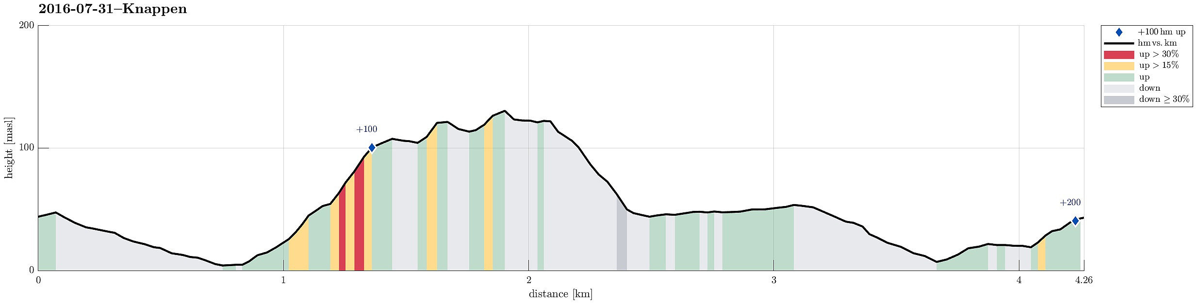 We started from Varden, walking down Marineveien and connecting to Bjørgeveien, where we turned left into Sandeidbrotet after only a few meters along Gjeddevatnet. This little side-street leads steeply up (into the direction of Knappatjørna). At "the top", where the street makes a sharp turn to the left, a hiking path leaves to the right (only a few meters above another side-road, which only connects to a private place instead). Following the hiking path (into northwestern direction) brings one nearby Røstafjellet, i.e., another residential area (north of Knappen and slightly elevated above Bjørgeveien). Before actually entering this area, another hiking path leaves to the left and upwards, first in western direction, but then, following the ridge, turning more and more into >>>
Langtrotten on Algrøyna---wild! :-)
- Datum:
- 30.07.2016
- Tourcharakter:
- Bergtour
- Tourlänge:
- 4:00h
- Entfernung:
- 6,8km
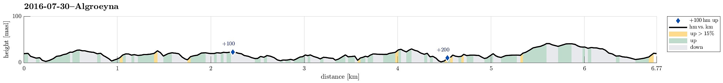 We parked near the bus stop Urhaugen (almost the last one on Algrøyna) and walked from there, first continuing on the road (Nordre Øyavegen, then Kongvikvegen). Near house #51 along Kongvikvegen, one leaves the road and descends down towards the eastern end of Kungvika. There, following one of the paths, we crossed over to the other, southern side that connects to Barmaneset, i.e., the middle of the three "fingers" of Algrøyna. Following the path, we walked westwards, between Urhaugen and Måshaugane, and continuing across Nordra Mynteidet further west and onto Barmaneset. The path leads to the innermost bay of Krabbakeila, where it isn't 100% obvious of how to continue further towards Langtrotten (one has to turn left, basically, walk down, across, and up again, and sneek >>>
Großglockner from Ködnitztal
- Datum:
- 17.07.2016
- Tourcharakter:
- Bergtour
- Tourlänge:
- 12:00h
- Entfernung:
- 15,7km
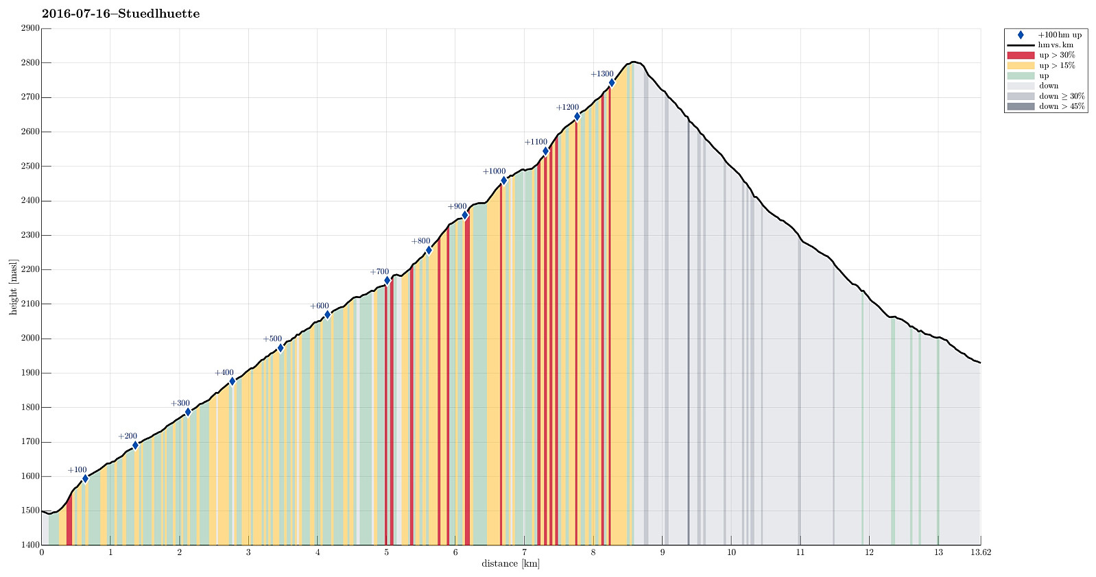
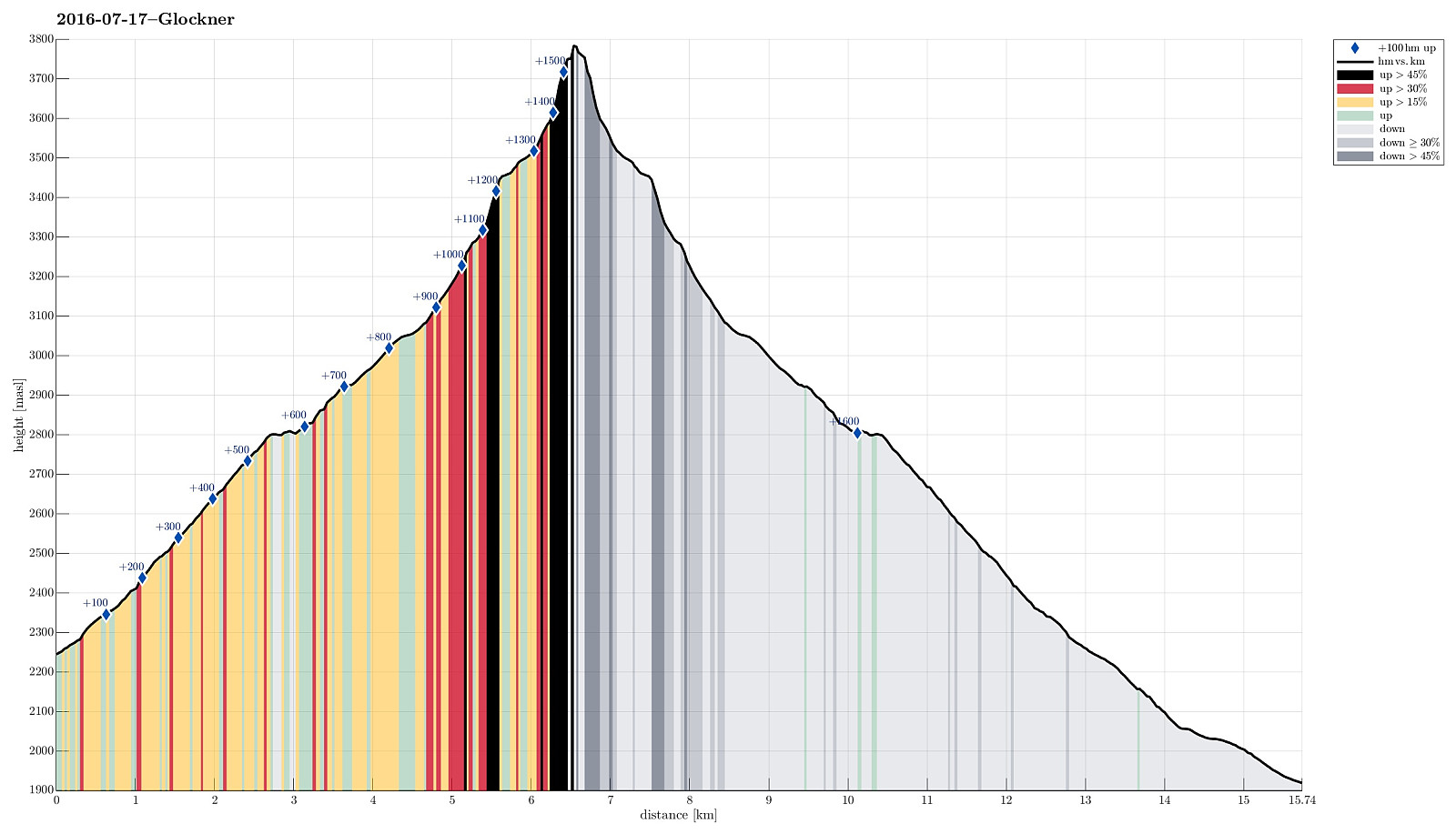 We started from Lucknerhaus, where a nice guy drove us up to Lucknerhuette (in order to give us an easy start into this hike)! From Lucknerhuette, we did a relaxed walk up to the Fanatscharte (and Stuedlhuette, there). On Stuedlhuette, we met our guide (from the Kalser Bergfuehrer) and discussed the weather (it really did not look promising, both in terms of rain/snow and also wind). After some thinking, we decided to still make an attempt, at least up to Adlersruhe (and Erzherzog-Johann-Huette, there). We started (into the freezing rain) and followed the "Normalweg", which leads around Schere, first, before then ascending on the upper-left side of Koednitzkees, before crossing over (to the east), leaving the glacier there, and continuing as a moderately easy climibing stretch >>>
Hiking up Teischnitztal
- Datum:
- 16.07.2016
- Tourcharakter:
- Bergtour
- Tourlänge:
- 5:00h
- Entfernung:
- 13,6km
 We started from the Spöttling-Taurer houses at the upper end of Kals am Grossglockner and headed for Teischnitztal from there. After only a few minutes, one connects to the road that leads further to Moaalm. Instead of following this road for long, we turned right just before crossing Teischnitzbach, and took a forrest road that winds upwards at the slopes of Tschenglkopf. When stepping out of the forrest at about 2100m sea-level, a dramatic canyon opens in front, leading to the upper parts of Teischnitztal. We continued on the forrest road also through this canyon until the place, where the valley opens up at the end of the canyon (there is also a small bridge that connects to the other, western side of this valley from there). Just before getting to this bridge, actually, we turned >>>
Boeses Weibl from Lucknerhaus
- Datum:
- 15.07.2016
- Tourcharakter:
- Bergtour
- Tourlänge:
- 7:00h
- Entfernung:
- 15,4km
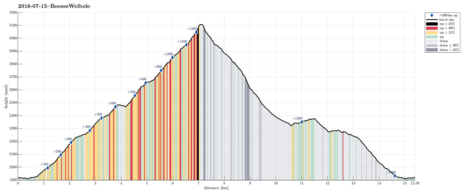 We started from Lucknerhaus and went first via Nigglalm to Oberfigeralm. From there, we continued into the valley of the Peischlachbach, heading for Peischlachtörl at 2484m. There, we turned right (into southern direction) and started the actual ascent to the Boeses Weibl. The ridge leads up to the Tschadinsattel, from which it only is several minutes to the top of the Boeses Weibl. Unfortunately, we could not reach the top, while the weather was still OK---so we had to imagine the great views from the top of this mountain. We then descended along the same route until we came to a place (on the ridge), where a path to the west, towards Tschadinalm, separates (at about 2760m sea-level). We then continued towards Tschadinalm (at about 2325m sea-level), before turning right again and connecting >>>
