Archiv - Nach Datum
Archiv - Nach Aktivität
-
Andere Tour (1)
- Kayaking (1)
-
Andere Wintertour (4)
- Schneeschuhtour (4)
-
Fahrradtour (137)
- Fahrradtour Straße (9)
- Fahrradtour gemischt (51)
-
Fußtour (740)
- Bergtour (363)
- Jogging (18)
- Spaziergang (89)
- Wanderung (270)
-
Skitour (4)
- Tourenskilauf (4)
Archiv - Nach Geografie
Peakbookfreunde


Gesammelte Listen
-
Bergen ≥ 50m pf. og ≥ 100 m.o.h.
(87/89)
 97%
97% -
Most dominating tops of the Bergen peninsula
(68/75)
90%
-
Utvalgte topper og turmål i Bergen
(316/350)
90%
-
Alle topper i Bergen
(357/398)
89%
-
Opptur Bergen
(100/113)
88%
-
De syv fjell rundt Bergen
(6/7)
85%
-
Sund ≥ 50m pf.
(14/18)
77%
-
Os ≥ 50m pf.
(25/34)
73%
-
Søyler (fastmerker) i Bergen
(68/100)
68%
-
Fjell ≥ 50m pf.
(21/32)
65%

Geitanipa
- Datum:
- 08.07.2017
- Tourcharakter:
- Bergtour
- Tourlänge:
- 2:00h
- Entfernung:
- 4,8km
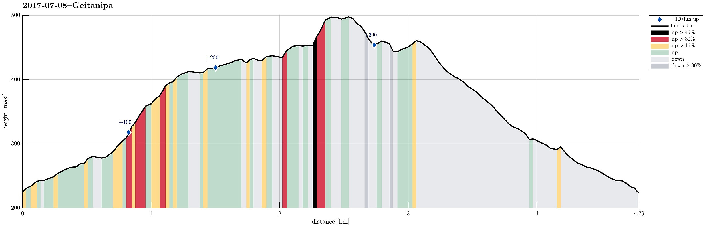 We started from Langhelle, between Trengereid and Vaksdal, at the end of the paved (small and narrow) road, which winds up there from E16 near the fjord. We first walked up a little longer along the gravel road until the point, where it makes a sharp turn right, leading further up to Seterkokane. We then followed a forest trail that brought us further up (in southeastern direction) to the saddle between Trollaberget and Geitanipa. At about this saddle, we decided to not descend to the southern side, but instead to connect to Geitanipa, instead. While there was not really any path or trail to Geitanipa, we still managed to get there without major difficulties (Geitanipa is, in fact, a bit steep on its eastern side, so it is necessary to carefully choose a good spot for ascending to it). >>>
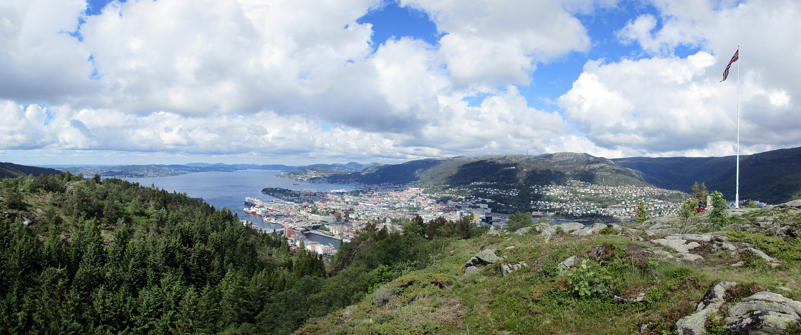
Summer evening on Lyderhorn
- Datum:
- 03.07.2017
- Tourcharakter:
- Bergtour
- Tourlänge:
- 2:00h
- Entfernung:
- 4,6km
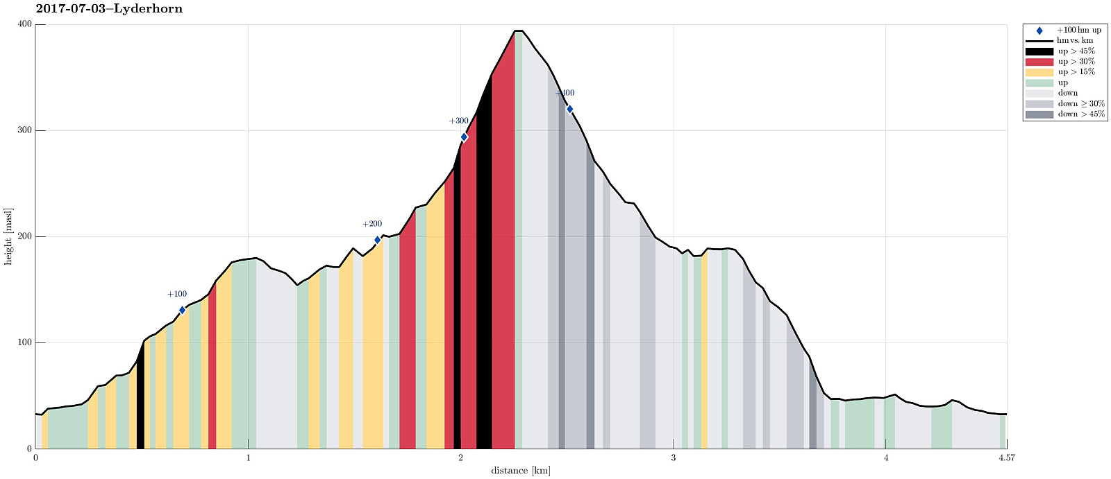 We took the car along road 557 towards Bjørndalen, where we parked right next to Bjørndalstjørna. We crossed the double-lane street (Lyderhornsveien) and found a narrow passage that led us up to Bjørndalsbakken. From there, we connected to Sildaberget and between houses 31 and 35 we found the narrow opening, which leads the path that brings one up the steep mountain-side there.
Before actually ascending to Lyderhorn, we first crossed Skarpafjellet in the south of Lyderhorn. Once up the little top, there, one can enjoy some very nice views in all directions.
In order to get further to Lyderhorn, we descended from Skarpafjellet on its northeastern side, avoiding the very steep side towards Grøvledalen. From the saddle, where also a power line is crossing, we then followed a path, which >>>
We took the car along road 557 towards Bjørndalen, where we parked right next to Bjørndalstjørna. We crossed the double-lane street (Lyderhornsveien) and found a narrow passage that led us up to Bjørndalsbakken. From there, we connected to Sildaberget and between houses 31 and 35 we found the narrow opening, which leads the path that brings one up the steep mountain-side there.
Before actually ascending to Lyderhorn, we first crossed Skarpafjellet in the south of Lyderhorn. Once up the little top, there, one can enjoy some very nice views in all directions.
In order to get further to Lyderhorn, we descended from Skarpafjellet on its northeastern side, avoiding the very steep side towards Grøvledalen. From the saddle, where also a power line is crossing, we then followed a path, which >>>
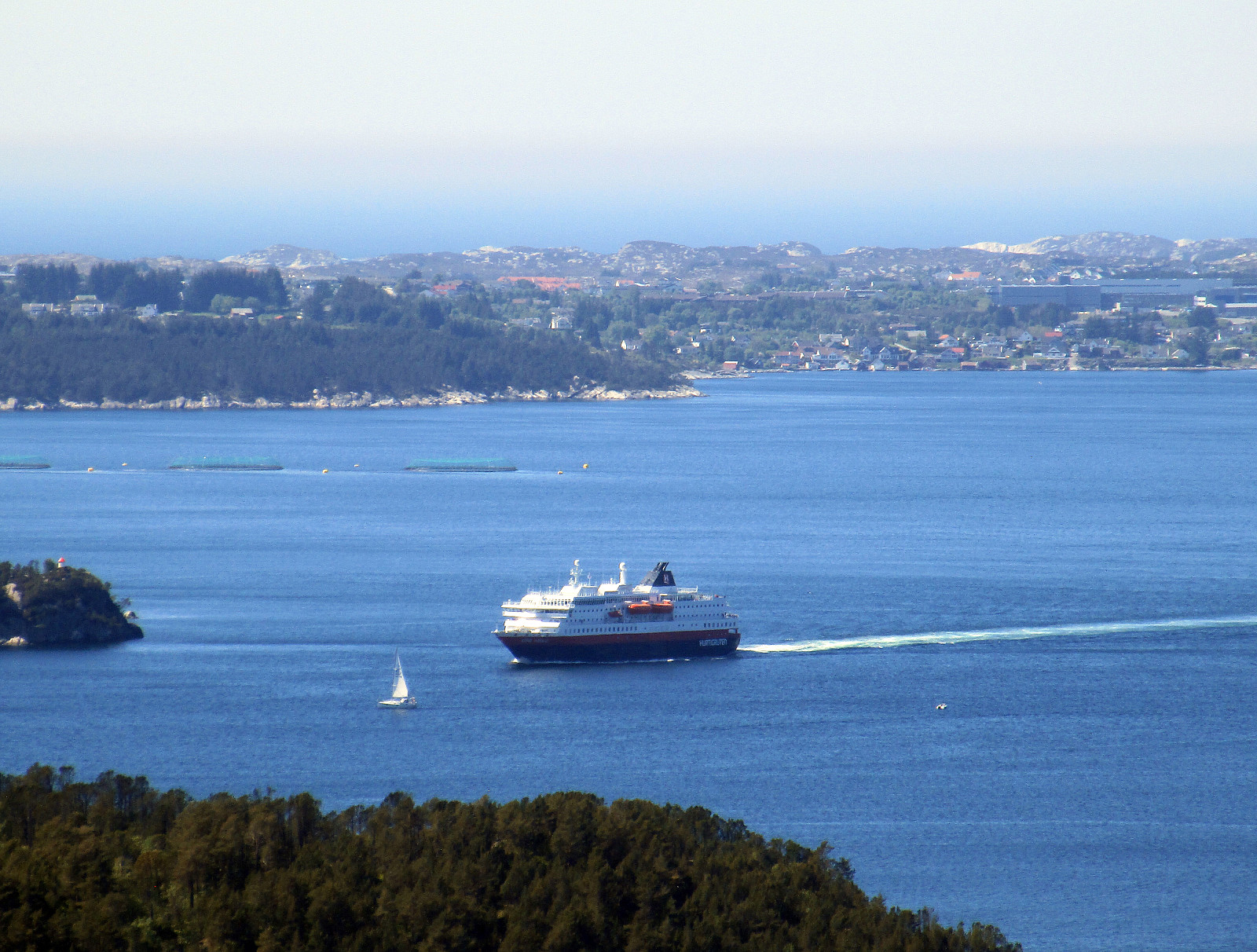
Meeting the North Atlantic at Skogsøya
- Datum:
- 24.06.2017
- Tourcharakter:
- Bergtour
- Tourlänge:
- 2:00h
- Entfernung:
- 5,3km
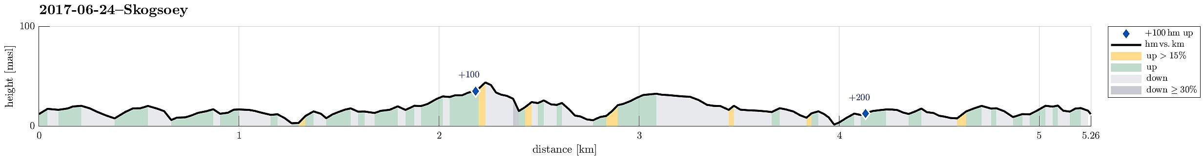 We took the car from Bergen to the west and then further north to Øygarden. On Ona, right next to Kollsnes, we left road 561 and continued on road 228 towards Herdleværet. On Skogsøyna, just before crossing the bridge to Herdleværet, we parked the car and started to hike towards the west, following the northern rim of Skogsøyna. First, we were positively impressed about work that seemingly was done quite recently to further improve this trail, making it easier to avoid wet and/or muddy shoes (at least to a certain degree). Nice! :-)
At the outer tip of Skogsøyna, we reached our goal for this day, Skoysøytua (some 50m above sea level and with nice views over the open Atlantic!). We explored the cliffs and watched the energetic ocean rumble against the rocks of Skogsøytua. We also >>>
We took the car from Bergen to the west and then further north to Øygarden. On Ona, right next to Kollsnes, we left road 561 and continued on road 228 towards Herdleværet. On Skogsøyna, just before crossing the bridge to Herdleværet, we parked the car and started to hike towards the west, following the northern rim of Skogsøyna. First, we were positively impressed about work that seemingly was done quite recently to further improve this trail, making it easier to avoid wet and/or muddy shoes (at least to a certain degree). Nice! :-)
At the outer tip of Skogsøyna, we reached our goal for this day, Skoysøytua (some 50m above sea level and with nice views over the open Atlantic!). We explored the cliffs and watched the energetic ocean rumble against the rocks of Skogsøytua. We also >>>
Cala del Cau from Far de San Sebastia
- Datum:
- 17.06.2017
- Tourcharakter:
- Bergtour
- Tourlänge:
- 2:00h
- Entfernung:
- 2,2km
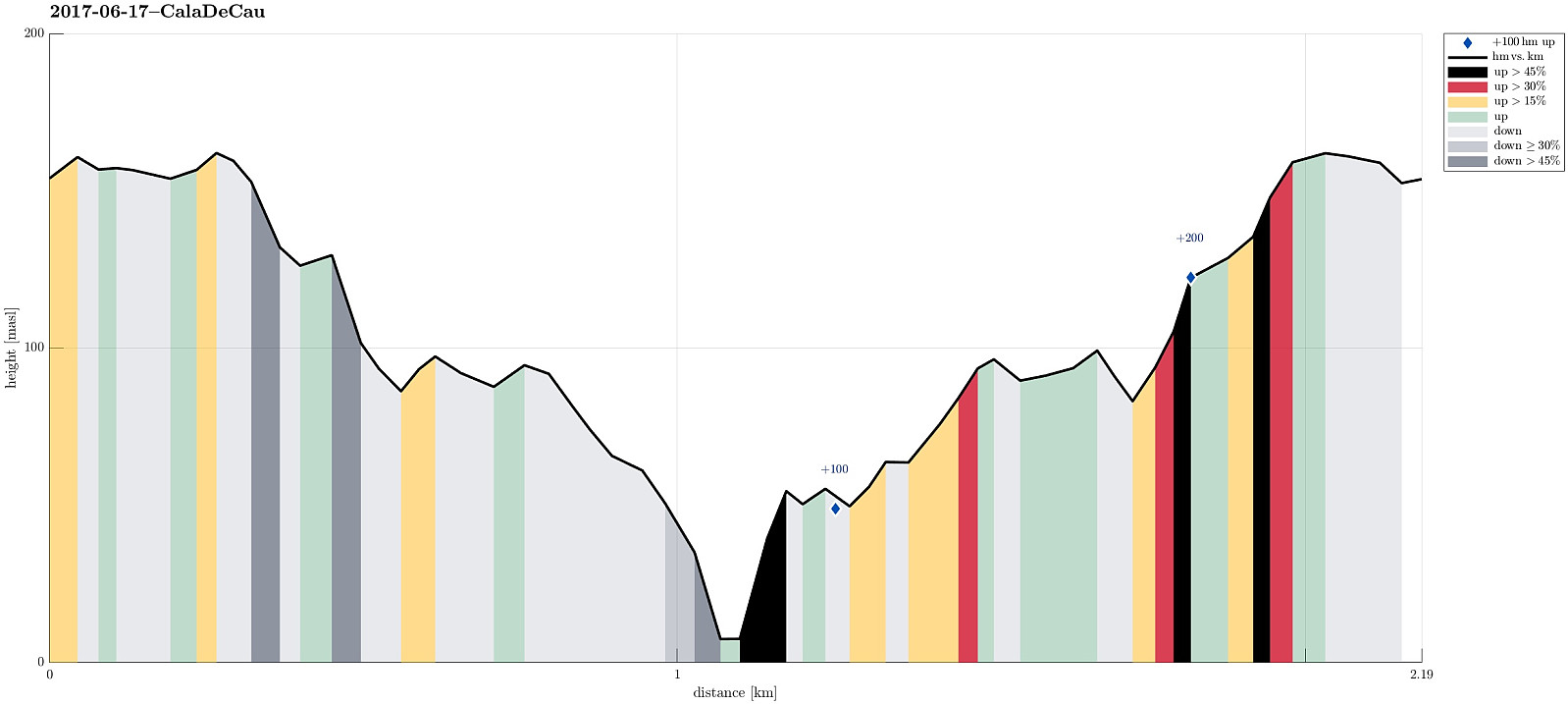 I started my trip in Barcelona with the goal to see a little of the wild and nice Costa Brava. After some driving, I started to head for Far de San Sebastia, mostly because I expected some nice views from there. The car brought me all the way up to this little hill and I parked right next to the restaurant Far de San Sebastia. I then explored the hill-top with Torre de Guaita de San Sebastia, overlooking the Mediterranean sea and also large parts of the nearby land. I found a little path at the steep eastern side facing the sea and followed it in northern direction. After a little up and down along the steep mountain side, I got the idea that I could try to get down to the sea (and explore also the waters there!). Following some small tracks through the forest, I found a path that headed >>>
Løvstakken and Strandafjellet
- Datum:
- 05.06.2017
- Tourcharakter:
- Bergtour
- Tourlänge:
- 2:00h
- Entfernung:
- 5,5km
 We parked right above Litlavatet up in Fyllingsdalen and started our (usual) ascent to Løvstakken (first towards Ragnefjellet, passing by the little water fall appropriately called Fossen). Once on the heights, we followed the usual route towards Løvstakken (first eastwards, then in southern direction along the ridge). Soon thereafter we arrived at Løvstakken (quite some others there, too). From the top of Løvstakken, we followed the trail downwards (mostly in northern direction), which leads directly to Strandafjellet. Instead of following the main trail further downwards in the direction of Bergen, we did the short ascent to Strandafjellet and enjoyed some nice views there. We then took the same path again down, before then walking around Strandafjellet on its southern side, descending >>>
Fana-cycling with Fanasåta
- Datum:
- 28.05.2017
- Tourcharakter:
- Fahrradtour gemischt
- Tourlänge:
- 5:00h
- Entfernung:
- 72,7km
 I took my bike southwards from Varden, Fyllingsdalen, first passing by Søreide into the direction of Hjellestad. After having crossed the street to the airport, I turned sharply left at Blomsterdalen, continuing on the small road #172 towards Fana. At Skeie, I made sure to connect to the even smaller road, which passes by Hordnesskogen. At Stend, I connected with the main road to Fana, #546, coming there from Rådalen. I then cycled by Fana and continued on road #163 up to Fanafjellet. Even though the height difference is not much, this ascent clearly is tougher than cycling on level ground. :-)
At Fanafjellet, I parked my bike in order to make a short detour to Fanasåta. Right before (north of) the big parking place on the saddle on Fanafjellet, a little forest road leaves to the northeast, >>>
I took my bike southwards from Varden, Fyllingsdalen, first passing by Søreide into the direction of Hjellestad. After having crossed the street to the airport, I turned sharply left at Blomsterdalen, continuing on the small road #172 towards Fana. At Skeie, I made sure to connect to the even smaller road, which passes by Hordnesskogen. At Stend, I connected with the main road to Fana, #546, coming there from Rådalen. I then cycled by Fana and continued on road #163 up to Fanafjellet. Even though the height difference is not much, this ascent clearly is tougher than cycling on level ground. :-)
At Fanafjellet, I parked my bike in order to make a short detour to Fanasåta. Right before (north of) the big parking place on the saddle on Fanafjellet, a little forest road leaves to the northeast, >>>
Cycling to Askøy with Folleseåsen
- Datum:
- 27.05.2017
- Tourcharakter:
- Fahrradtour gemischt
- Tourlänge:
- 3:00h
- Entfernung:
- 30,8km
 We started our little cycling trip in the south of Fyllingsdalen and took Bjørgeveien towards Loddefjord. From there, we connected to Kjøkkelvikveien and at Nybø, we connected to Sundby Hvorups vei, which brings cyclists (and pedestrians) to the southern end of the large bridge to Askøy (drivers take a tunnel). We crossed over the Askøy-bridge and followed the sidewalk to the place, where a bigger bus-stop is. There, right behind the bus-stop, a steep path is leading downwards to Skarholmvegen. Turning sharply right, once down there, we took Skarholmvegen towards the west on the southern edge of Askøy. We followed this road until we came to Strusshamn, where we continued northover (and upwards), until we got to Follesevegen. There, we continued again westwards (a little), until >>>
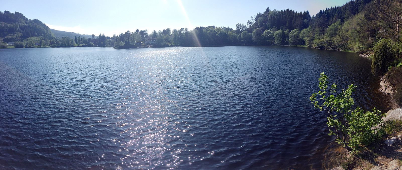
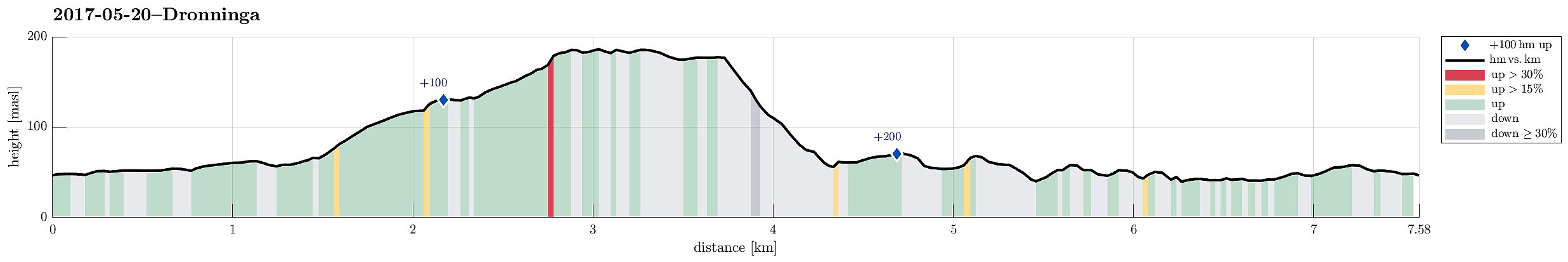
Dronninga on Askøy
- Datum:
- 20.05.2017
- Tourcharakter:
- Bergtour
- Tourlänge:
- 2:00h
- Entfernung:
- 7,6km
 We took the car from Bergen to Askøy and continued northwards on road #562 in the direction of Ravnanger. At Haugland, right after crossing over Loneelvi and then passing under a small bridge, we left the main road to Hauglandsmyra, where we parked at once.
In order to get to Dronninga, we walked first along Hauglandsmyra (the one part of it, which first leads northwards, between houses on the left and some meadow on the right). This brought us to Rispeleitet, which eventually leads in eastern direction (then really towards Dronninga). At the very end of Rispeleitet (at Kolbeinsmyra) the paved road becomes a stone road (maybe not for regular cars), which we followed all to the end (repeatedly one also finds signs, leading the way towards Dronninga). Very close to the "top" of >>>
We took the car from Bergen to Askøy and continued northwards on road #562 in the direction of Ravnanger. At Haugland, right after crossing over Loneelvi and then passing under a small bridge, we left the main road to Hauglandsmyra, where we parked at once.
In order to get to Dronninga, we walked first along Hauglandsmyra (the one part of it, which first leads northwards, between houses on the left and some meadow on the right). This brought us to Rispeleitet, which eventually leads in eastern direction (then really towards Dronninga). At the very end of Rispeleitet (at Kolbeinsmyra) the paved road becomes a stone road (maybe not for regular cars), which we followed all to the end (repeatedly one also finds signs, leading the way towards Dronninga). Very close to the "top" of >>>
Askøy-cycling with Åsebøåsen
- Datum:
- 14.05.2017
- Tourcharakter:
- Fahrradtour gemischt
- Tourlänge:
- 3:30h
- Entfernung:
- 53,4km
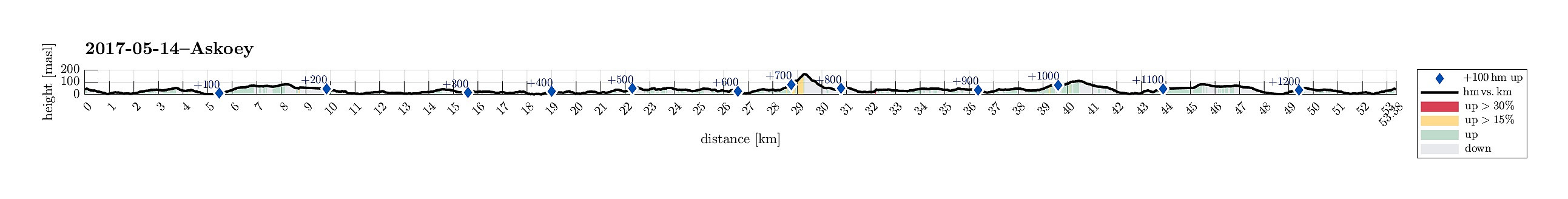 I took my bicycle from Varden in the southwest of Fyllingsdalen and followed first Bjørgeveien towards Loddefjord. Shortly before getting there, I first thought to take the pedestrians' bridge over Lyderhornveien in order to get to Bjørndalsbakken. I was mislead, there, however, since the according signs were crossed out. Thus, I thought that I had no other choice than to use Lyderhornveien in order to get to Loddefjord (not the nicest street to cycle). From Loddefjord, I continued along Lyderhornveien in northern direction (here it's fully OK to cycle), until I got to Kjøkkelvikveien, which I followed further northwards. Via Krabbedalsflaten, I got further to Sundby Hvorups vei, which I cycled upwards and over a minor top in order to connect to the big Askøy-bridge (only possible >>>
Gravdalsfjellet, Olsokfjellet, and Damsgårsfjellet
- Datum:
- 16.04.2017
- Tourcharakter:
- Bergtour
- Tourlänge:
- 2:15h
- Entfernung:
- 6,1km
 We took the car to Laksevåg/Lyngbø and parked right at the beginning of Eliasmarken. From there, we started to walk; first up to Lyngbøveien and so further into Nygårdslien (and upwards this road). At the upper end of Nygårdslien, we connected to the hiking path, which starts/ends there. Quickly, we ascended (moderately steeply) to the height where the path starts to flatten out towards the saddle between Gravdalsfjellet (in the southwest) and Damsgårdsfjellet (in the northeast). At the point, where four paths meet, we turned right (into southwestern direction) and continued our ascent to Gravdalsfjellet. Shortly later, we arrived at the top of Gravdalsfjellet and enjoyed an all-around view from there. From there, we first walked into the direction of Viggohytten, but turned left >>>
