Archiv - Nach Datum
Archiv - Nach Aktivität
-
Andere Tour (1)
- Kayaking (1)
-
Andere Wintertour (4)
- Schneeschuhtour (4)
-
Fahrradtour (137)
- Fahrradtour Straße (9)
- Fahrradtour gemischt (51)
-
Fußtour (740)
- Bergtour (363)
- Jogging (18)
- Spaziergang (89)
- Wanderung (270)
-
Skitour (4)
- Tourenskilauf (4)
Archiv - Nach Geografie
Peakbookfreunde


Gesammelte Listen
-
Bergen ≥ 50m pf. og ≥ 100 m.o.h.
(87/89)
 97%
97% -
Most dominating tops of the Bergen peninsula
(68/75)
90%
-
Utvalgte topper og turmål i Bergen
(316/350)
90%
-
Alle topper i Bergen
(357/398)
89%
-
Opptur Bergen
(100/113)
88%
-
De syv fjell rundt Bergen
(6/7)
85%
-
Sund ≥ 50m pf.
(14/18)
77%
-
Os ≥ 50m pf.
(25/34)
73%
-
Søyler (fastmerker) i Bergen
(68/100)
68%
-
Fjell ≥ 50m pf.
(21/32)
65%

Visiting Kumamoto Castle
- Datum:
- 29.06.2025
- Tourcharakter:
- Bergtour
- Tourlänge:
- 1:30h
- Entfernung:
- 3,2km
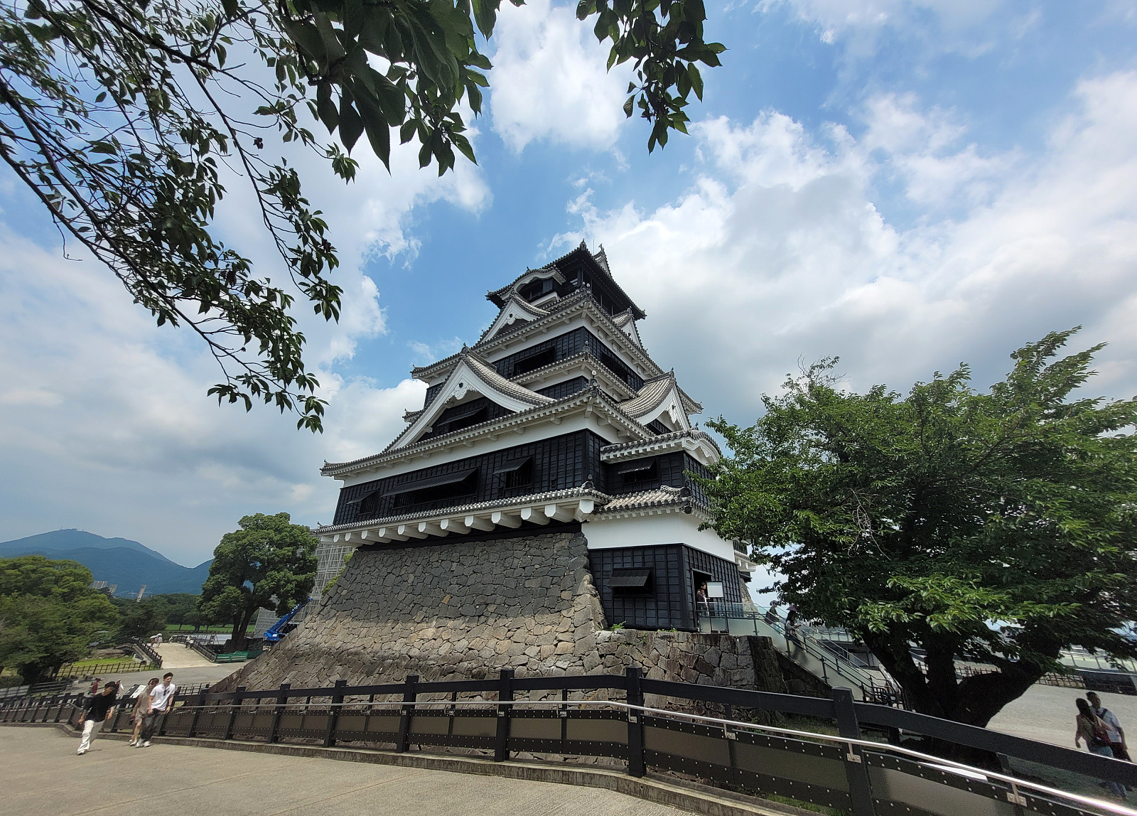 We had chosen to stay over night in Kumamoto to see Kumamoto Castle. After finding the actual entry to the castle area, we then approached it via a big bridge, which is errected to bypass major renovation work that became necessary after an earthquake had caused serious damage to multiple structure at and around the historc castle. It was possible, though, to enter the castle and to make a tour through it (with many, many others!). Eventually, we just made it back in an attempt to limit our time in the substantial heat of the day.
Selected photos are available as Google photo album .
See also the related FB-page Hiking around Bergen, Norway .
We had chosen to stay over night in Kumamoto to see Kumamoto Castle. After finding the actual entry to the castle area, we then approached it via a big bridge, which is errected to bypass major renovation work that became necessary after an earthquake had caused serious damage to multiple structure at and around the historc castle. It was possible, though, to enter the castle and to make a tour through it (with many, many others!). Eventually, we just made it back in an attempt to limit our time in the substantial heat of the day.
Selected photos are available as Google photo album .
See also the related FB-page Hiking around Bergen, Norway .
Nakadake (Kuju mountains) from Makinoto Pass
- Datum:
- 28.06.2025
- Tourcharakter:
- Wanderung
- Tourlänge:
- 5:00h
- Entfernung:
- 12,2km
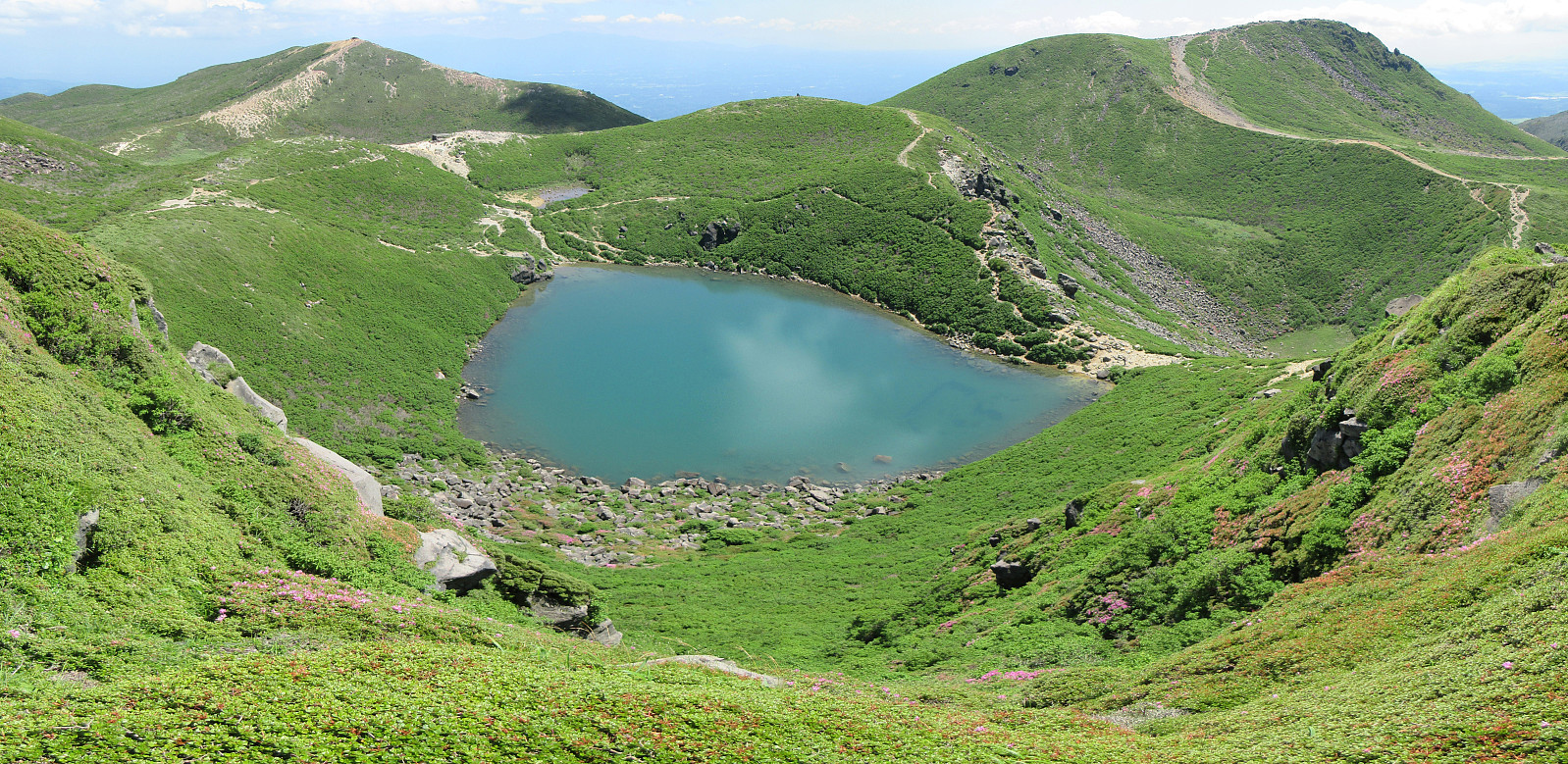 It was one of our goals for our visit to Kyushu to make a nice hike near Mt. Aso and this hike in the Kuju mountains, north of the massive caldera of volcano Aso, seemed very nice from its description. To get started, we drove to the Makinoto Pass in the West of Mt. Nakadake, but found that all parking spots had been taken, already. A bit further down the road, however, we found a place, where we could leave the car. After first walking back to the pass, we then followed the main trail in easterly direction. Gaining height steadily, we came to a place, where it was to Mt. Ogigahana to the right, and to "all other tops" to the left. Just shortly after choosing the latter option, we then followed a side-trail (without any signs) to get up to Mt. Hossho (not choosing the "main >>>
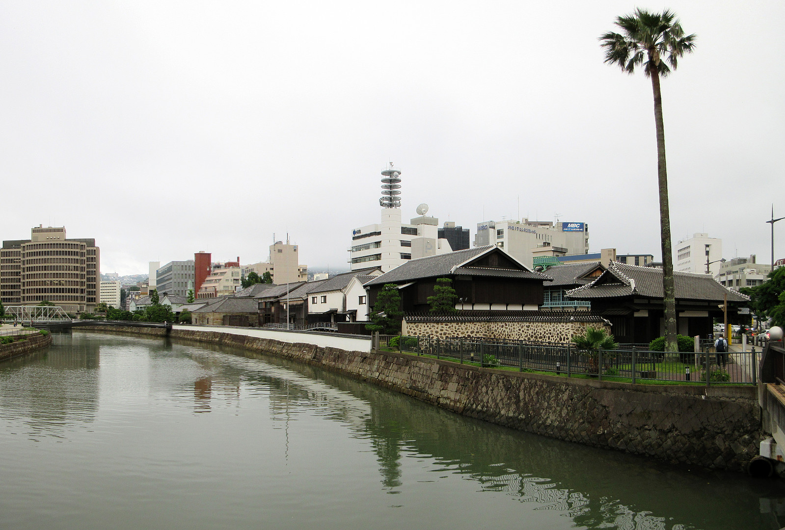
Evening attempt to reach Mt. Inasa
- Datum:
- 26.06.2025
- Tourcharakter:
- Spaziergang
- Tourlänge:
- 1:30h
- Entfernung:
- 4,2km
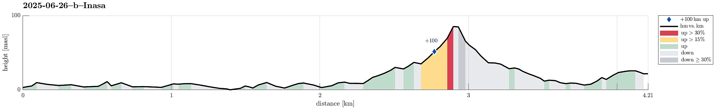 After first visiting the Atom Bomb Museum and Peace Park, earlier the same day, we then thought that it would be nice to take night looks at Nagasaki from Mt. Inasa. We first walked along Uragami River northwards, in order to find a trail that we had spotted on OpenCycleMap and which was supposed to bring us up to Mt. Inasa from the Fuchimachi part of Nagasaki. After walking around the Mitsubishi Industries near the valley station of the Nagasaki Ropeway, we then aimed at the road leading up to Fuchimachi. At this highest-most point of a side-road, however, we had to understand that finding a trail there was too optimistic. Also a local resident made it clear to us that there was no way further up from there! We thus retreated back down and instead connected to a bus stop to get up to >>>
Hypocenter Park, Atomic Bomb Museum, and Peace Park
- Datum:
- 26.06.2025
- Tourcharakter:
- Spaziergang
- Tourlänge:
- 5:30h
- Entfernung:
- 5,0km
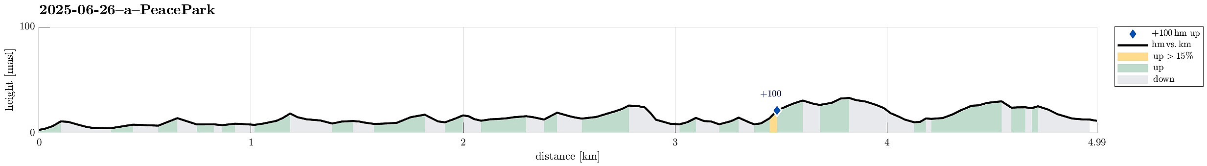 One main goal for the visit of Nagasaki, obviously, was to visit the Atom Bomb Museum, along with the surrounding areas. To get there, we walked northwards from the main railway station, passing by the large and modern Stadium City of Nagasaki. Continuing along Sanno Street, the first strong impression came with the one-legged Torii Gate and a plate, explaining its brutal history. Continuing further northwards, we then first visited the Hypocenter Park, which now marks the place, where -- right above -- the atom bomb exploded. After spending time in this park, we then walked up to the Atom Bomb Museum. Also there, we could take substantial time to carefully visit the museum as well as the peace hall. When were all through it, we then walked over to the Peace Park, after crossing over >>>
Visiting Dejima, the former Dutch Trading Post
- Datum:
- 25.06.2025
- Tourcharakter:
- Spaziergang
- Tourlänge:
- 1:30h
- Entfernung:
- 3,6km
 After a long Shinkansen transfer from Kyoto, we still wished to stretch our legs a little and thus decided to visit the former island of Dejima before going to bed. Waling south from the main railway station in Nagasaki, we quickly approached Dejima from the northwest. Even though we had read about it up front, we still were surprised to experience, how small this exclusive trading post in fact was. Going there in the evening had the advantage that we basically had the site for us and we therefore could take a good chunk of time to walk all around it and experience it closely.
Selected photos are available as Google photo album .
See also the related FB-page Hiking around Bergen, Norway .
After a long Shinkansen transfer from Kyoto, we still wished to stretch our legs a little and thus decided to visit the former island of Dejima before going to bed. Waling south from the main railway station in Nagasaki, we quickly approached Dejima from the northwest. Even though we had read about it up front, we still were surprised to experience, how small this exclusive trading post in fact was. Going there in the evening had the advantage that we basically had the site for us and we therefore could take a good chunk of time to walk all around it and experience it closely.
Selected photos are available as Google photo album .
See also the related FB-page Hiking around Bergen, Norway .
Hiking Mt. Inari with the 1000 Torii gates
- Datum:
- 23.06.2025
- Tourcharakter:
- Bergtour
- Tourlänge:
- 3:00h
- Entfernung:
- 6,8km
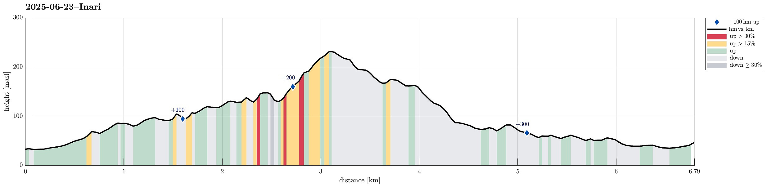 We first took a bus towards the NW of the Fushimi Inari Shrine, then walking up to the shrine (among many, many other tourists!). Further upwards, we first followed the main route, plassing through numerous red torii gates. Slightly north of Omokaru Stone, we then left the main trail, following a side-trail towards the East (Fushimi Kandakara Shrine). There, and following this minor side-trail further eastwards, we entered an amazing bamboo forest, soon later reaching an old cemetary in the woods. By that time, a thunderstorm had developed with some rain, adding to the very special atmosphere in the forest. A bit further along the trail, we then tried to find the Shiragiku waterfall, but turned around in the bamboo forest because to too many fallen bamboo trees, blocking our progress. >>>
Hiking down from Mt. Hiei
- Datum:
- 22.06.2025
- Tourcharakter:
- Wanderung
- Tourlänge:
- 4:00h
- Entfernung:
- 7,5km
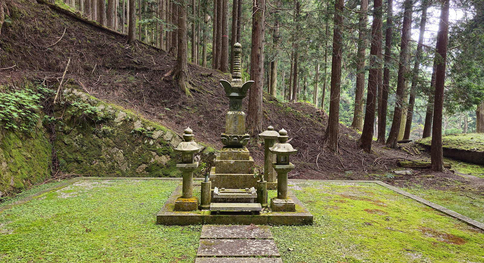 We wished to visit Mt. Hiei in the NE of central Kyoto, but were not ready to hike up to it, given the high summer temperatures. We thus chose to take, first, the Eizan Cable Car and, then, the Eizan Ropeway, up to a place near the top of Mt. Hiei. Walking eastwards from there, we first made it to the actual top of Mt. Hiei, before descending along a hiking trail to the graveyard behind the Enryakuji Temple. Walking through this graveyard in the forest, early in the morning, was a special moment. After visiting the Enryakuji Temple (several of the buildings), we then hiked down the mountain along a hiking trail towards the East (in parallel to the cable car that comes up from Sakamoto). It was impressive to see that quite a few others hiked in the opposite direction, i.e., up the mountain >>>
Visiting Nishiki Market in Kyoto
- Datum:
- 21.06.2025
- Tourcharakter:
- Spaziergang
- Tourlänge:
- 2:30h
- Entfernung:
- 6,3km
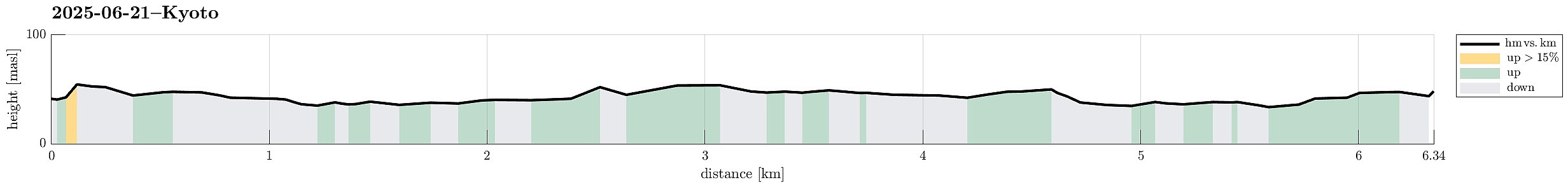 Quite a bit jet-lagged, we still wished to make a nice walk through the narrow streets of Kyoto, picking Nishiki Market, north of the main train station of Kyoto, as our goal. On our way north, we also passed by the Higashi Hongan-ji Temple, but they were already closing their gates for the day. Walking along off-beat, narrow streets gave us some good and apparently authentic impression of Kyoto. Nishiki Market is then really impressive. Buzzling with people, numerous small shops offering food and other goods, even in the evening. Back, we then took a slighly more easterly route, adding to our Kyoto impression. A good start to some nice weeks in Japan! :-)
Selected photos are available as Google photo album .
See also the related FB-page Hiking around Bergen, Norway .
Quite a bit jet-lagged, we still wished to make a nice walk through the narrow streets of Kyoto, picking Nishiki Market, north of the main train station of Kyoto, as our goal. On our way north, we also passed by the Higashi Hongan-ji Temple, but they were already closing their gates for the day. Walking along off-beat, narrow streets gave us some good and apparently authentic impression of Kyoto. Nishiki Market is then really impressive. Buzzling with people, numerous small shops offering food and other goods, even in the evening. Back, we then took a slighly more easterly route, adding to our Kyoto impression. A good start to some nice weeks in Japan! :-)
Selected photos are available as Google photo album .
See also the related FB-page Hiking around Bergen, Norway .
Steinfjellet from Osavatnet (via Vossavardane)
- Datum:
- 09.06.2025
- Tourcharakter:
- Wanderung
- Tourlänge:
- 7:00h
- Entfernung:
- 16,4km
 We decided to make a hike to Steinfjellet in the east of Gulltjørna. After comparing different approach options, we decided to hike Steinfjellet from Osavatnet (via Vossavardane). This gave us also the opportunity to explore the direct ascent to Vossavardane from Songstaddalen via Gasebrekkene. After parking near Osavatnet, we thus first hiked into the direction of Songstaddalen (northwest of Svartavassrinden). From Songstaddalen, we then entered the lower stretches of Gasebrekkene (steep, yes, but well doable -- without a trail, of course). Getting up to the saddle between Hotten in the south and Tjørndalsskaret in the north proved well possible, while steep as expected. The only one point to consider is that it's not all that clear how to avoid a bush war up there (possible, but one >>>
Luxembourg (and back via the Plateau de Kirchberg)
- Datum:
- 03.06.2025
- Tourcharakter:
- Bergtour
- Tourlänge:
- 5:00h
- Entfernung:
- 9,1km
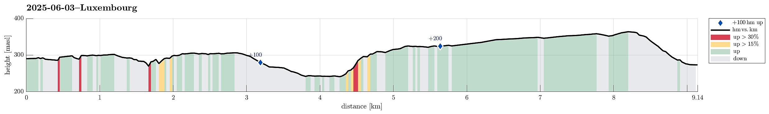 Starting with a nice and interesting guided tour through the historic city of Luxembourg, this walk was ended with a late evening return to the hotel via the Plateau de Kirchberg. Places visited: Pont Adolphe, Place de la Constitution, Chemin de la Corniche, Place Guillaume II, Place d'Armes, Montée de Clausen, Fort Obergrünewald, Fort Thüngen, Philharmonie Luxembourg, and the Plateau de Kirchberg.
Selected photos are available as Google photo album .
See also the related FB-page Hiking around Bergen, Norway .
Starting with a nice and interesting guided tour through the historic city of Luxembourg, this walk was ended with a late evening return to the hotel via the Plateau de Kirchberg. Places visited: Pont Adolphe, Place de la Constitution, Chemin de la Corniche, Place Guillaume II, Place d'Armes, Montée de Clausen, Fort Obergrünewald, Fort Thüngen, Philharmonie Luxembourg, and the Plateau de Kirchberg.
Selected photos are available as Google photo album .
See also the related FB-page Hiking around Bergen, Norway .
