Archiv - Nach Datum
Archiv - Nach Aktivität
-
Andere Tour (1)
- Kayaking (1)
-
Andere Wintertour (4)
- Schneeschuhtour (4)
-
Fahrradtour (137)
- Fahrradtour Straße (9)
- Fahrradtour gemischt (51)
-
Fußtour (740)
- Bergtour (363)
- Jogging (18)
- Spaziergang (89)
- Wanderung (270)
-
Skitour (4)
- Tourenskilauf (4)
Archiv - Nach Geografie
Peakbookfreunde


Gesammelte Listen
-
Bergen ≥ 50m pf. og ≥ 100 m.o.h.
(87/89)
 97%
97% -
Most dominating tops of the Bergen peninsula
(68/75)
90%
-
Utvalgte topper og turmål i Bergen
(316/350)
90%
-
Alle topper i Bergen
(357/398)
89%
-
Opptur Bergen
(100/113)
88%
-
De syv fjell rundt Bergen
(6/7)
85%
-
Sund ≥ 50m pf.
(14/18)
77%
-
Os ≥ 50m pf.
(25/34)
73%
-
Søyler (fastmerker) i Bergen
(68/100)
68%
-
Fjell ≥ 50m pf.
(21/32)
65%

Heihillerhornet, Kjerringafjellet, and Ottanosi
- Datum:
- 26.04.2025
- Tourcharakter:
- Wanderung
- Tourlänge:
- 5:30h
- Entfernung:
- 10,7km
 We expected nice weather and thus planned for a nice hike! :-) We took the ferry from Hatvik near Os in the south of Bergen to Venjaneset in Fusa. From there, we first drove to Eikelandsosen and then to Holdhus, where we left road 48 to get up to the parking place at Heihillervegen (one pays some road fee for driving up there: NOK 75 plus about the same amount "on top" for "lagring og oppslag" as well as for "fakturagebyr"). Our first goal was to hike up to Heihillerhornet and so we "retreated" from the parking place a short stretch along the road to the place, where the trail starts (there's a sign, also). After first finding the trail head, we still managed to get off the trail within only meters from the road! :-) Instead of heading further eastwards, >>>
Brøknipa from Båtaleitet (back via Borgasætra)
- Datum:
- 20.04.2025
- Tourcharakter:
- Wanderung
- Tourlänge:
- 4:00h
- Entfernung:
- 8,8km
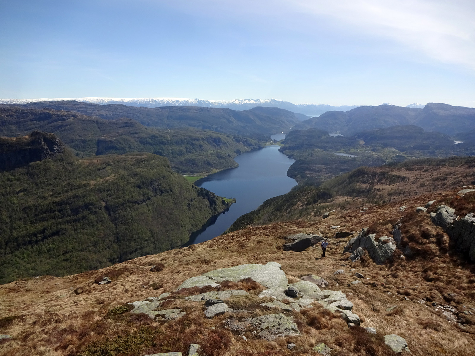
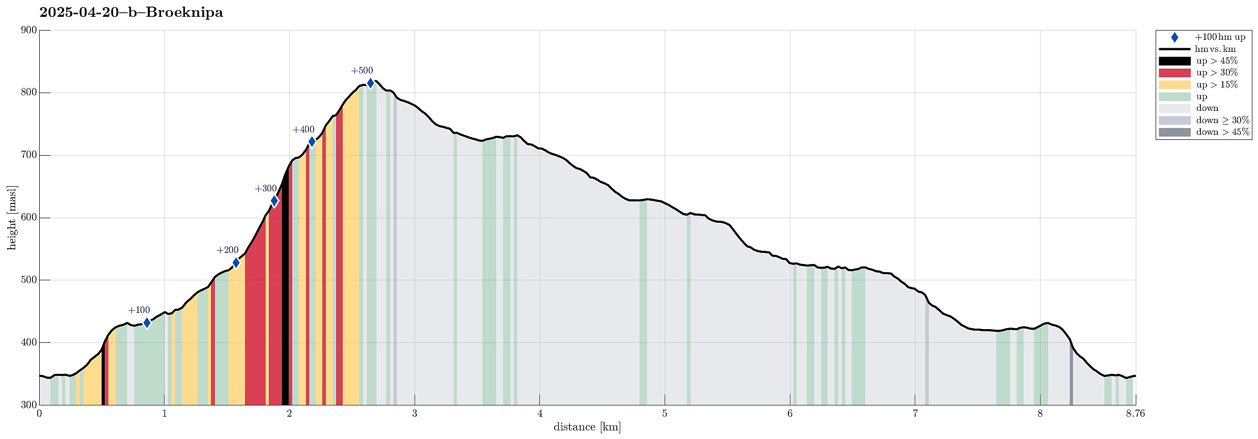 Probably it was about time to explore the new stone steps that had been laid down along the ascent path to Brøknipa (from Båtaleitet). We parked at the (now large) parking place at Båtaleitet (and paid our fee -- also that's new, as it seems). We then followed the main trail towards Brøknipa and the full parking lot had not fooled us: lots of others were on this trail, as well. While the project seems to be still ongoing, at least to some degree, significant parts of the ascent trail are now covered by impressive stone steps. Especially in the steepest section, up to Middagshaugen, this massively upgraded trail is now very impressive for sure! Enjoying the excellent views, already on our way up, we then made the "obligatory" short break on the top of Brøknipa, also taking >>>
Towards Olsnesnipa from Olsneset
- Datum:
- 20.04.2025
- Tourcharakter:
- Bergtour
- Tourlänge:
- 1:30h
- Entfernung:
- 3,2km
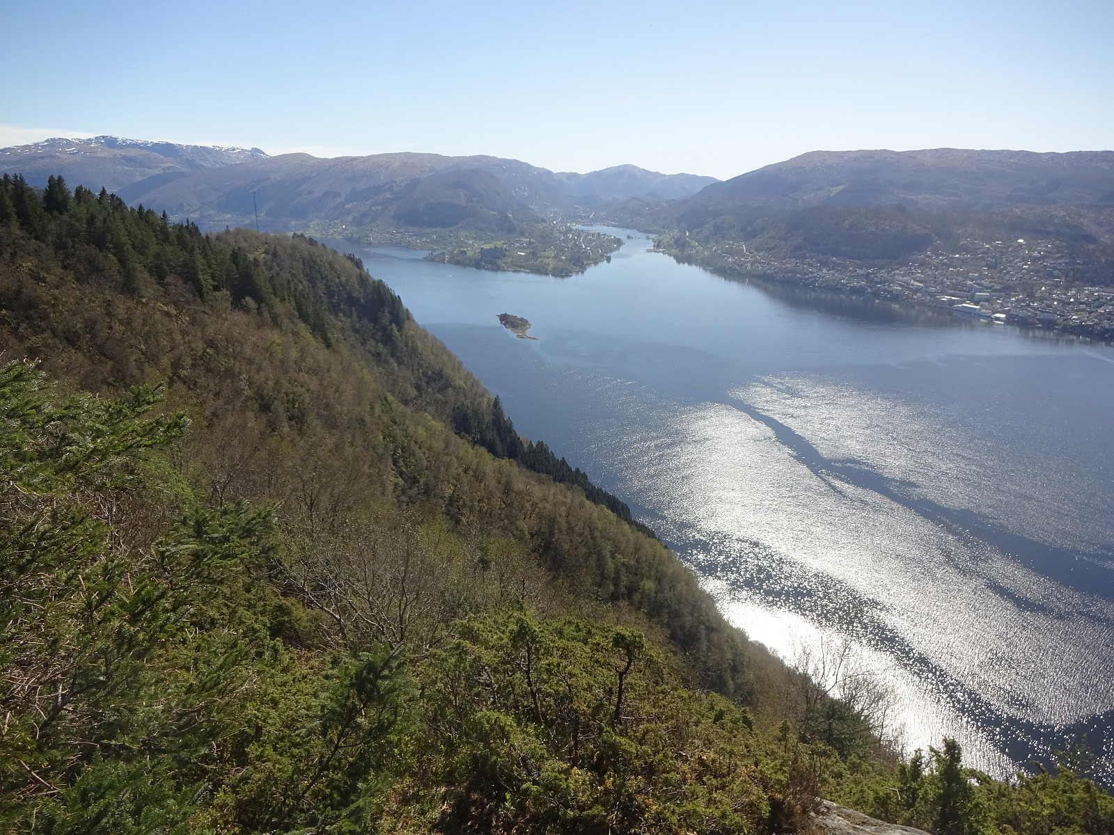
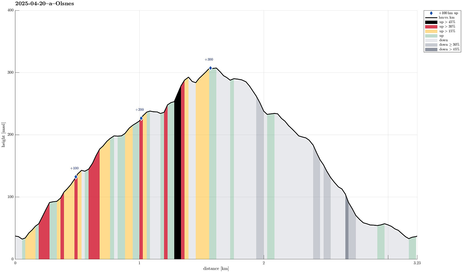 I was in the mood for a quick "before breakfast" stroll and thus headed to explore the heights north of Olsneset on Osterøy. After only a few meters it got confirmed that this would -- at least at large -- be an off-trail excursion. I still gained elevation relatively quickly, searching my way through the vegetation. Several times, I emerged at places with great views (including panoramic views across Sørfjorden -- nice!). Once up to about 240 masl, I got confronted with slightly more challenging terrain -- continuing "whereever" was no longer an option. After having made it down to the foot of an impressive cliff (in my west), I then followed this cliff upwards "right under it". This brought me to a place, where I could easily cross over to the heights, >>>
Hånipa from Reigstad
- Datum:
- 19.04.2025
- Tourcharakter:
- Bergtour
- Tourlänge:
- 2:30h
- Entfernung:
- 5,1km
 After taking the ferry from Breistein to Valestrand on Osterøy, we drove a bit further southwards and parked near Reigstad. We then followed the main trail across the northern ridge of Reigstadfjellet southwards to get up to Hånipa. We then continued along the high ridge, high above Sørfjorden, a bit more southwards, before turning left and descending into Reigstaddalen, following the main trail. Due to some major forest works, which had impacted the forest road through Reigstaddalen significantly, we then decided to follow Geitryggen instead of staying in the valley for getting back. About half way down, however, we still connected back with the forest road through Reigstaddalen. Somehow, without fully sinking into all the mud, we still made it back down and back to the car! :-) All >>>
Utapåeggi from Indre Songstad, down Innapåeggi
- Datum:
- 18.04.2025
- Tourcharakter:
- Wanderung
- Tourlänge:
- 3:30h
- Entfernung:
- 8,1km
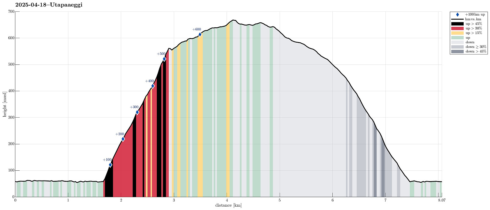 We expected some nice weather and thus thought that we could do a short hike, exploring a new way up to Utapåeggi (via Indre Songstad). We thus headed east from Bergen in order to get to road E16, which would bring us to our starting point near Sørfjorden. Instead of sunshine, however, we drove through some light rain on our way there, questioning our weather information! :-) Near Romslo, we left road E16 and parked right next to Romslo, expecting that we would come down there later. To get to Indre Songstad, where we wanted to start the ascent to Utepåeggi, we first needed to walk a bit along Romslovegen (the old road, parallel to E16). Just before coming to Indre Songstad, however, we thought that we could already start our ascent (quite a bit steep there, however). Our first goal >>>
To Bergen via Løvstakken
- Datum:
- 16.04.2025
- Tourcharakter:
- Wanderung
- Tourlänge:
- 3:00h
- Entfernung:
- 10,1km
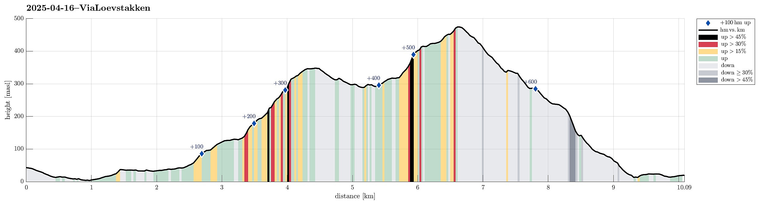 Given a quite nice day, we decided to walk to Bergen (via Løvstakken). We first walked up to Orrtuvatnet, before then continuing (further up) to Lyshovden. Next, we wished to get up to Gullsteinen and we did so via Nils Langhelles vei (using a trail that starts basically where the last house stands at Nils Langhelles vei). From Gullsteinen, we then followed the main trail up to Løvstakken. To continue further to Bergen, we aimed at Juvdalen. The descent to Løvstien is quite steep, though. Altogether a nice option to get to Bergen! :-)
Selected photos are available as Google photo album .
See also the related FB-page Hiking around Bergen, Norway .
Web page WestCoastPeaks.com provides useful information about Løvstakken .
Given a quite nice day, we decided to walk to Bergen (via Løvstakken). We first walked up to Orrtuvatnet, before then continuing (further up) to Lyshovden. Next, we wished to get up to Gullsteinen and we did so via Nils Langhelles vei (using a trail that starts basically where the last house stands at Nils Langhelles vei). From Gullsteinen, we then followed the main trail up to Løvstakken. To continue further to Bergen, we aimed at Juvdalen. The descent to Løvstien is quite steep, though. Altogether a nice option to get to Bergen! :-)
Selected photos are available as Google photo album .
See also the related FB-page Hiking around Bergen, Norway .
Web page WestCoastPeaks.com provides useful information about Løvstakken .
Nubbevatnet (twice) via Nattlandsfjellet
- Datum:
- 12.04.2025
- Tourcharakter:
- Fahrradtour gemischt
- Tourlänge:
- 4:30h
- Entfernung:
- 31,3km
 We had agreed to make a short hike together, from Nattlandsfjellet to Nubbevatnet. To get there, we took our bikes, first along Nordåsvatnet, then via Paradis up to Nattlandsfjellet. From the parking strip south of Sveane, we then hiked up (via Sveane) and over the long ridge into the direction of Orrehaugane, before then crossing over to Nubbevatnet. At Baunehytten, on the north end of Nubbevatnet, we then enjoyed a nice little break. After enjoying the sun a little, we then walked back towards Ramsdalen and Nattlandsfjellet, following the main route (gravel road southwards, also connecting to Helgeseter). Once back at the parking at Nordre Nattlandsfjellet, we learned that the keys to unlock two of our bike locks weren't with us as expected. After a bit of searching, we thought that >>>
Sauafjellet via Heiane from Rolsvåg
- Datum:
- 05.04.2025
- Tourcharakter:
- Wanderung
- Tourlänge:
- 5:45h
- Entfernung:
- 13,2km
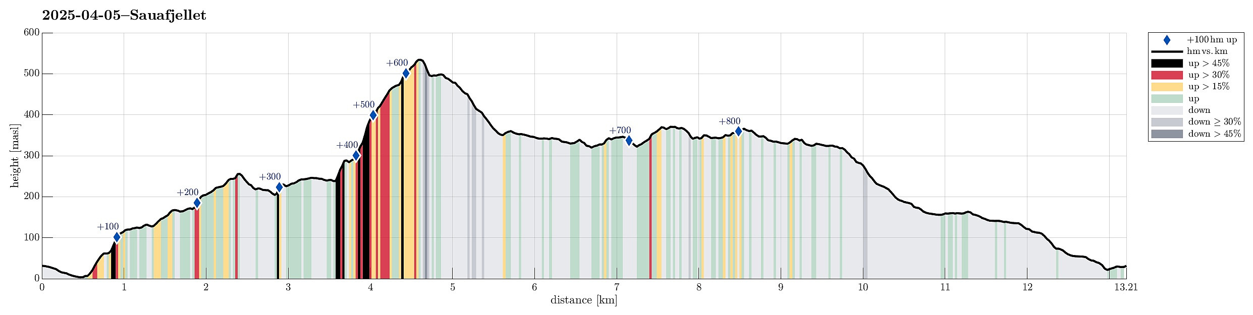 The idea was to visit Sauafjellet (from Rolsvåg). We parked near Vågasanden, right next to Solbjørgsvegen. The plan was to first hike to Heiane, in the southeast of Sauafjellet, before then connecting to the northeastern ridge of Sauafjellet. On the map, it had looked promising to start near Furneset (off trail) and then hike northwards up to Heiane. After getting around house 759 (and a dog that seemed moderately excited), we then made quick and nice progress upwards. Almost straight northwards, we soon found ourselves on Heiane, enjoying views already in all directions. As we had remembered from last time, a bit of careful navigation is recommended north of Heiane (the terrain is a bit rugged and several small lakes are around there, too). We still found a good traverse without >>>
