Archiv - Nach Datum
Archiv - Nach Aktivität
-
Andere Tour (1)
- Kayaking (1)
-
Andere Wintertour (4)
- Schneeschuhtour (4)
-
Fahrradtour (137)
- Fahrradtour Straße (9)
- Fahrradtour gemischt (51)
-
Fußtour (740)
- Bergtour (363)
- Jogging (18)
- Spaziergang (89)
- Wanderung (270)
-
Skitour (4)
- Tourenskilauf (4)
Archiv - Nach Geografie
Peakbookfreunde


Gesammelte Listen
-
Bergen ≥ 50m pf. og ≥ 100 m.o.h.
(87/89)
 97%
97% -
Most dominating tops of the Bergen peninsula
(68/75)
90%
-
Utvalgte topper og turmål i Bergen
(316/350)
90%
-
Alle topper i Bergen
(357/398)
89%
-
Opptur Bergen
(100/113)
88%
-
De syv fjell rundt Bergen
(6/7)
85%
-
Sund ≥ 50m pf.
(14/18)
77%
-
Os ≥ 50m pf.
(25/34)
73%
-
Søyler (fastmerker) i Bergen
(68/100)
68%
-
Fjell ≥ 50m pf.
(21/32)
65%

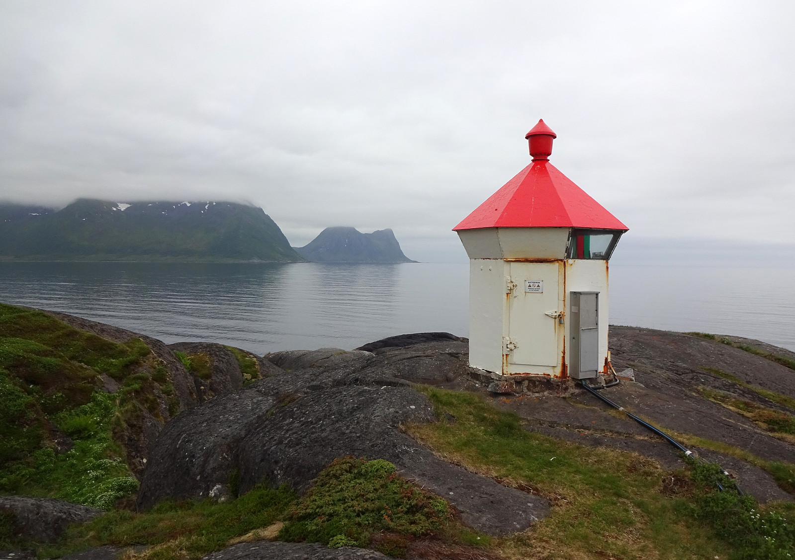
Bekkarhalsen at Skøyteneset
- Datum:
- 25.06.2023
- Tourcharakter:
- Spaziergang
- Tourlänge:
- 4:00h
- Entfernung:
- 7,3km
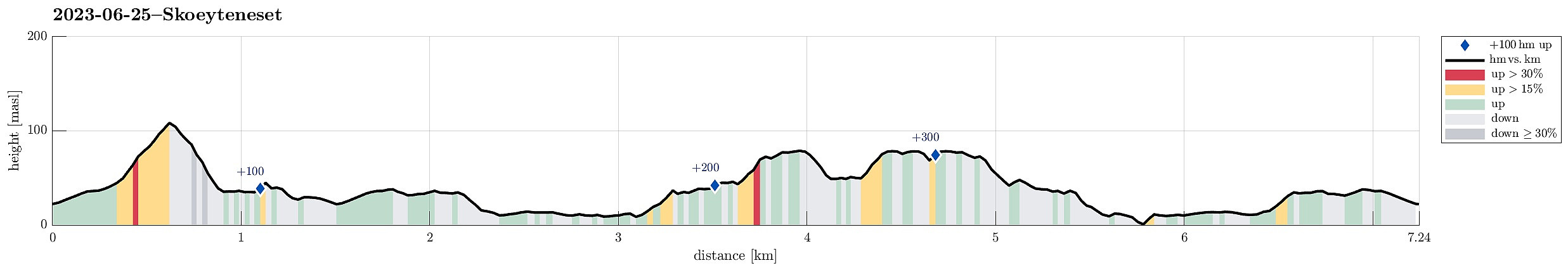 With no major mountain tops to see (due to low hanging clouds), we decided to make another excursion along the shoreline -- this time to Skøyteneset from Medfjordvær. We parked near Knuten in the north of Mefjordvær and walked up to Halsen, first. Then we included Knuten, which offers some nice views (even though it's not really high). We then also stepped down to the small lighthouse in the north of Knuten, before returning to Mefjordvær along the outer route around Knuten on its eastern side (probably the connection for those, who have to work at the lighthouse; or had to, previously). After this short Knuten intermezzo, we then headed out to Skøyteneset along the marked trail in the west of Knutevika, reading first about Russehula and then about Munken. Further out, the trail leads >>>
Lykteneset at Flatneset
- Datum:
- 24.06.2023
- Tourcharakter:
- Spaziergang
- Tourlänge:
- 3:30h
- Entfernung:
- 10,4km
 The clouds were hanging low and we decided to make an excursion along the coastline to Flatneset. We left Hamnveien near the bridge over Straumen, heading (for a few meters only) towards Straumsnes. After turning right (into Morrvika), we just continued a few hundred meters further until we parked at a small parking spot near the beach. To get over to Flatneset, we had to first cross over Lavollskjosen. We followed a simple trail over Skjåneshaugen to get to the southwestern side of Kjosen. Then, we walked along it (in southeastern direction) until we found a place, where we thought that crossing over should be possible (and indeed it was). On the other side, we then changed course into northwestern direction, heading towards Lykteneset on the outermost end of Flatneset. At Lavollen, >>>
Hellandsneset
- Datum:
- 23.06.2023
- Tourcharakter:
- Spaziergang
- Tourlänge:
- 0:30h
- Entfernung:
- 1,4km
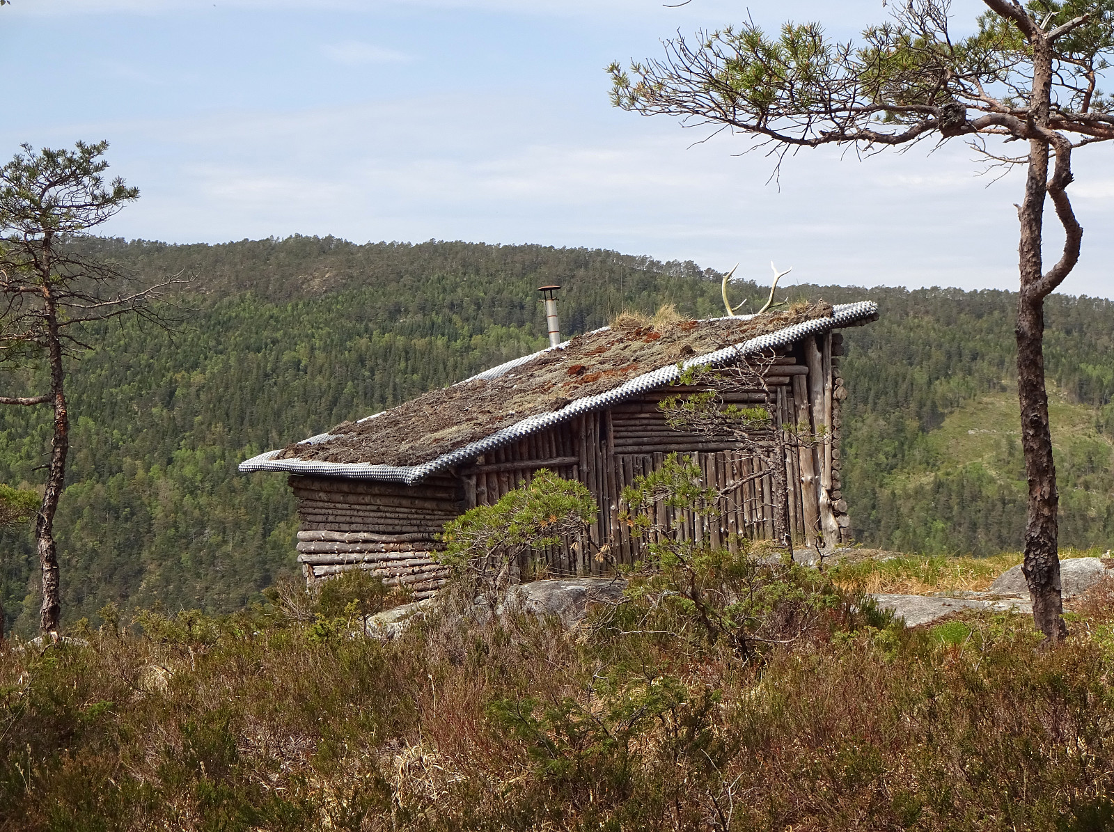
 We stopped for taking a look at the long closed Nickel mine west of Hamn i Senja. Difficult to imagine that hundreds of miners worked here for an extended period to break out nickel ore from this mine, which extends down to about 40 meteres below sea level (now all filled with water). From the mine, we then made a short walk out to the tip of Hellandsneset, enjoying some nice views (both towards Bergsøyan and also out towards the open North Atlantic). All in all a very short walk -- but still nice! :-)
Selected photos are available as Google photo album .
See also the related FB-page Hiking around Bergen, Norway .
Web page UT.no from the Norwegian Trekking Association recommends a similar hike .
We stopped for taking a look at the long closed Nickel mine west of Hamn i Senja. Difficult to imagine that hundreds of miners worked here for an extended period to break out nickel ore from this mine, which extends down to about 40 meteres below sea level (now all filled with water). From the mine, we then made a short walk out to the tip of Hellandsneset, enjoying some nice views (both towards Bergsøyan and also out towards the open North Atlantic). All in all a very short walk -- but still nice! :-)
Selected photos are available as Google photo album .
See also the related FB-page Hiking around Bergen, Norway .
Web page UT.no from the Norwegian Trekking Association recommends a similar hike .
Gjenekletten and Søre Sandknappen on Blomøyna
- Datum:
- 19.06.2023
- Tourcharakter:
- Wanderung
- Tourlänge:
- 3:00h
- Entfernung:
- 7,3km
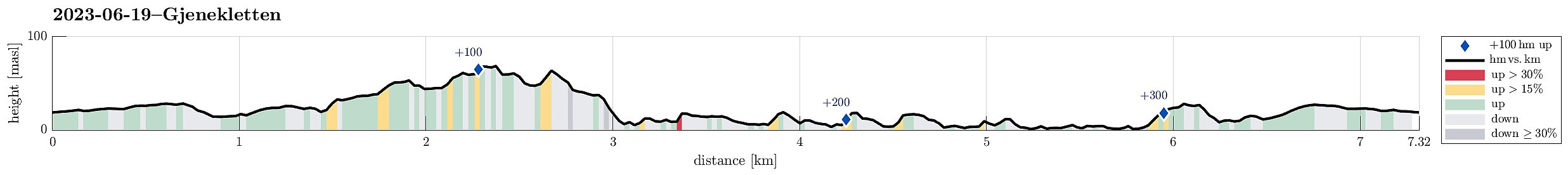 We were up for another trip to Øygarden and chose Blomøyna for a short hike. We left Bergen towards the west and turned right (northwards) on Sotra near Kolltveit. We then followed road #561 until we passed Rong and arrived at Blomøyna via the bridge over Ulvsundet. We then parked right next to road Blomøyvegen (south of Søre Sæle). From there, we first walked along the road (northwards) for a bit (until we had walked around Blomvatnet on our left). There, at Blom, we then left the road towards the right (north) in order to find a connection to Gjenekletten. We first found a proper trail, leading to house #255. Before getting there, we then left this trail and crossed over a little ditch in the northwest of this house. Further north, however, we couldn't see any nice continuation >>>
Gulltjørna from Risnes
- Datum:
- 18.06.2023
- Tourcharakter:
- Wanderung
- Tourlänge:
- 3:00h
- Entfernung:
- 6,6km
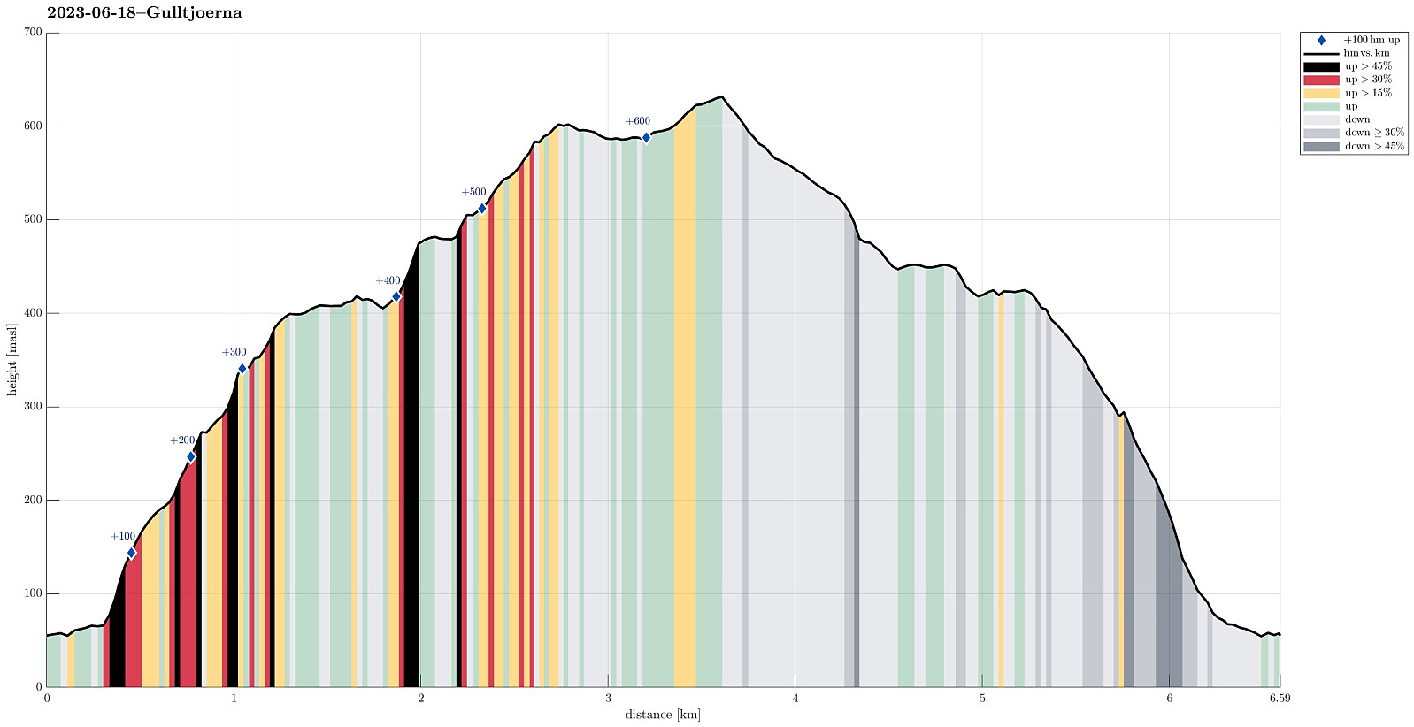 We liked the idea to paying Gulltjørna another visit and we also liked the idea to do it, again, from the north. Following E16 into the east of Bergen, we left the main road near Romslo in order to connect to the old, narrow road that would bring us closer to Risnes. We found a spot where we could park alongside the road just a short stretch before actually getting all the way to Risnes. From there, we walked first for a short stretch along the road in order to get to our starting point of the actual hike. Right next to the bridge over the stream that comes down there through Risnes, we saw that one could use the steps of the water processing building there to get a bit further up (and away from the road). Where the stairs end, however, one needs to revert to actual hiking (there it's >>>
Biking around Hordnesskogen
- Datum:
- 17.06.2023
- Tourcharakter:
- Fahrradtour gemischt
- Tourlänge:
- 2:00h
- Entfernung:
- 31,8km
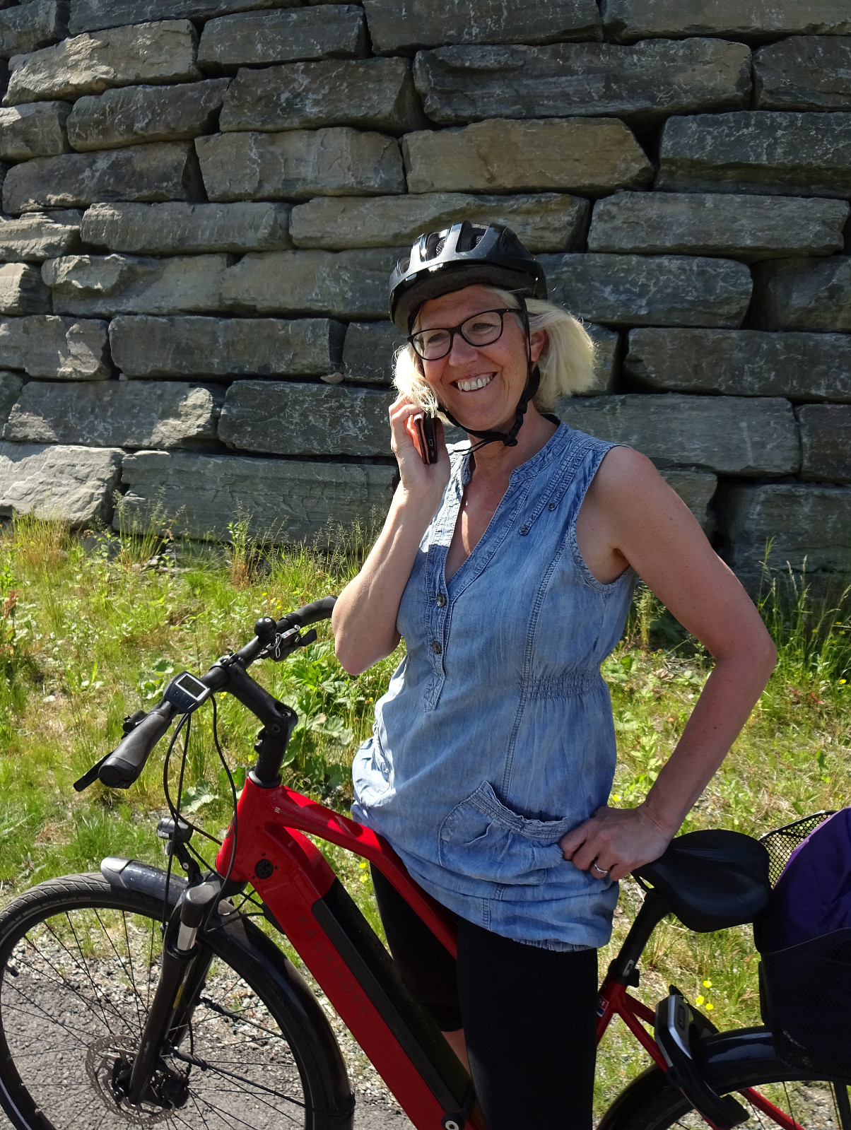 With also the other bike repaired, we headed for a new biking-round around Nordåsvatnet. Again, we started our joint ride near the light rail station at Kristianborg, heading south (into the direction of Nesttun). This time, we surrounded Kristianborgvannet on the other, eastern side, though. Following the main bike route southwards, we eventually ended up in Rådalen. There, we decided that we would bike around Hordnesskogen in its south. Afte first following Rådalen further south (to the north of the school at Stend), we then turned right and onto Hordesvegen. Near house #202 along Hordnesvegen, we then came to a parking opportunity for those, who wish to start into Hordnesskogen from the south there. There, we headed into Hordnesskogen (in northwestern direction) for a few hundred >>>
Round around Ono
- Datum:
- 04.06.2023
- Tourcharakter:
- Wanderung
- Tourlänge:
- 3:00h
- Entfernung:
- 9,3km
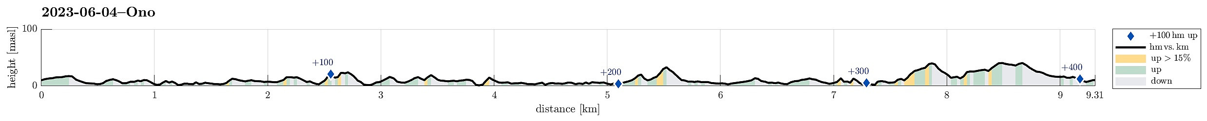 While checking for new places in Øygarden that we had not visited so far, we found Ono and decided to make a hike there. After driving first westwards out of Bergen (towards Sotra), we then turned right (in northern direction) near Kolltveit, following then road #561. At Rong, we then turned left (westwards, again) in order to get over to Ono (passing the school of Rong along Svartevikvegen). After crossing two small bridges, we had arrived at Ono. There, we parked "at once" next to the road Onevegen. The southern part of Ono is well marked for hikers -- especially those, who wish to visit Dethloffhytta in the southwest of Ono. We followed first this main trail (in southwestern direction) until we crossed over the inner end of Stekkane. On the other, southern side, we then >>>
Biking around Nordåsvatnet
- Datum:
- 03.06.2023
- Tourcharakter:
- Fahrradtour gemischt
- Tourlänge:
- 2:00h
- Entfernung:
- 25,0km
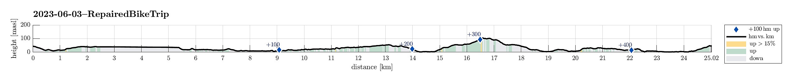 We had a bike to pick up and wished to ride a little round -- not at the least to also see that it was functioning as well as expected. We started the joint ride at the bike shop near the light rail station at Kristianborg, heading first southwards along Kanalveien and then following the track of the no longer existing railway into the direction of Nesttun. At the church of Skjold, we then turned right and cycled down to Skjoldbukta along Harald Skjolds veg. From there, we then cycled up to Nordåsvegen, which we then followed "all around" Nordåsen. On the south, we then descended to Steinsvikvegen. Following Steinsvikvegen around Steinsviken and Søviken, we connected to Søreide and from there further northwards to Sandeidet. All in all, a nice bike ride! :-)
See also the >>>
We had a bike to pick up and wished to ride a little round -- not at the least to also see that it was functioning as well as expected. We started the joint ride at the bike shop near the light rail station at Kristianborg, heading first southwards along Kanalveien and then following the track of the no longer existing railway into the direction of Nesttun. At the church of Skjold, we then turned right and cycled down to Skjoldbukta along Harald Skjolds veg. From there, we then cycled up to Nordåsvegen, which we then followed "all around" Nordåsen. On the south, we then descended to Steinsvikvegen. Following Steinsvikvegen around Steinsviken and Søviken, we connected to Søreide and from there further northwards to Sandeidet. All in all, a nice bike ride! :-)
See also the >>>
Gullsteinen from Varden
- Datum:
- 28.05.2023
- Tourcharakter:
- Wanderung
- Tourlänge:
- 1:30h
- Entfernung:
- 7,8km
 We wished to get some fresh air and thus headed for Gullsteinen (from Varden). We first descended from Varden to Sælevatnet, before then surrounding Bondegården in its north. Via Ture Nermans vei we then connected to Rekdalsveien, which we then followed "all the way up" to the point, where one can step down some stairs to the sports area in Fjellsdalen. We then stepped up Hattedalen to get to Bråtet. From there, we then started our ascent to Gullsteinen. While one of us found a way (more a "way"!) up to Knultrane, the other one continued along the gravel road to Nils Langhellesvei (where we met, again, then). From there, it was then up via the southern ridge to Gullsteinen, mostly following the nice trails along this ridge. From the top of Gullsteinen, however, >>>
Rindafjellet from Gåssand (wow!)
- Datum:
- 21.05.2023
- Tourcharakter:
- Wanderung
- Tourlänge:
- 8:00h
- Entfernung:
- 17,0km
 We expected a nice Sunday and headed out for a special "project": Rindafjellet from Gåssand! This clearly became a bit of an adventure and (quite) a bit of a challenge, also. It may be good to read the following before possibly retracing our hiking track (the hike was very nice, yes, but also a bit long and very steep up to Rindafjellet!).
We drove south from Bergen (along E39 into the direction of Os) and took the small road that leads to Gåssand, after all. Before actually coming to the south end of Ytsta Raudlivatnet, however, we parked at the relatively large parking spot near Hatlelia. From there, we then first walked further along Gåssandvegen, crossing Nordelva north of Gåssand. At the other side of the bridge, we turned left and followed a track across Nauslia that >>>
We expected a nice Sunday and headed out for a special "project": Rindafjellet from Gåssand! This clearly became a bit of an adventure and (quite) a bit of a challenge, also. It may be good to read the following before possibly retracing our hiking track (the hike was very nice, yes, but also a bit long and very steep up to Rindafjellet!).
We drove south from Bergen (along E39 into the direction of Os) and took the small road that leads to Gåssand, after all. Before actually coming to the south end of Ytsta Raudlivatnet, however, we parked at the relatively large parking spot near Hatlelia. From there, we then first walked further along Gåssandvegen, crossing Nordelva north of Gåssand. At the other side of the bridge, we turned left and followed a track across Nauslia that >>>
