Archiv - Nach Datum
Archiv - Nach Aktivität
-
Andere Tour (1)
- Kayaking (1)
-
Andere Wintertour (4)
- Schneeschuhtour (4)
-
Fahrradtour (137)
- Fahrradtour Straße (9)
- Fahrradtour gemischt (51)
-
Fußtour (740)
- Bergtour (363)
- Jogging (18)
- Spaziergang (89)
- Wanderung (270)
-
Skitour (4)
- Tourenskilauf (4)
Archiv - Nach Geografie
Peakbookfreunde


Gesammelte Listen
-
Bergen ≥ 50m pf. og ≥ 100 m.o.h.
(87/89)
 97%
97% -
Most dominating tops of the Bergen peninsula
(68/75)
90%
-
Utvalgte topper og turmål i Bergen
(316/350)
90%
-
Alle topper i Bergen
(357/398)
89%
-
Opptur Bergen
(100/113)
88%
-
De syv fjell rundt Bergen
(6/7)
85%
-
Sund ≥ 50m pf.
(14/18)
77%
-
Os ≥ 50m pf.
(25/34)
73%
-
Søyler (fastmerker) i Bergen
(68/100)
68%
-
Fjell ≥ 50m pf.
(21/32)
65%

Exploring snowy Brandset
- Datum:
- 31.12.2022
- Tourcharakter:
- Schneeschuhtour
- Tourlänge:
- 2:00h
- Entfernung:
- 5,2km
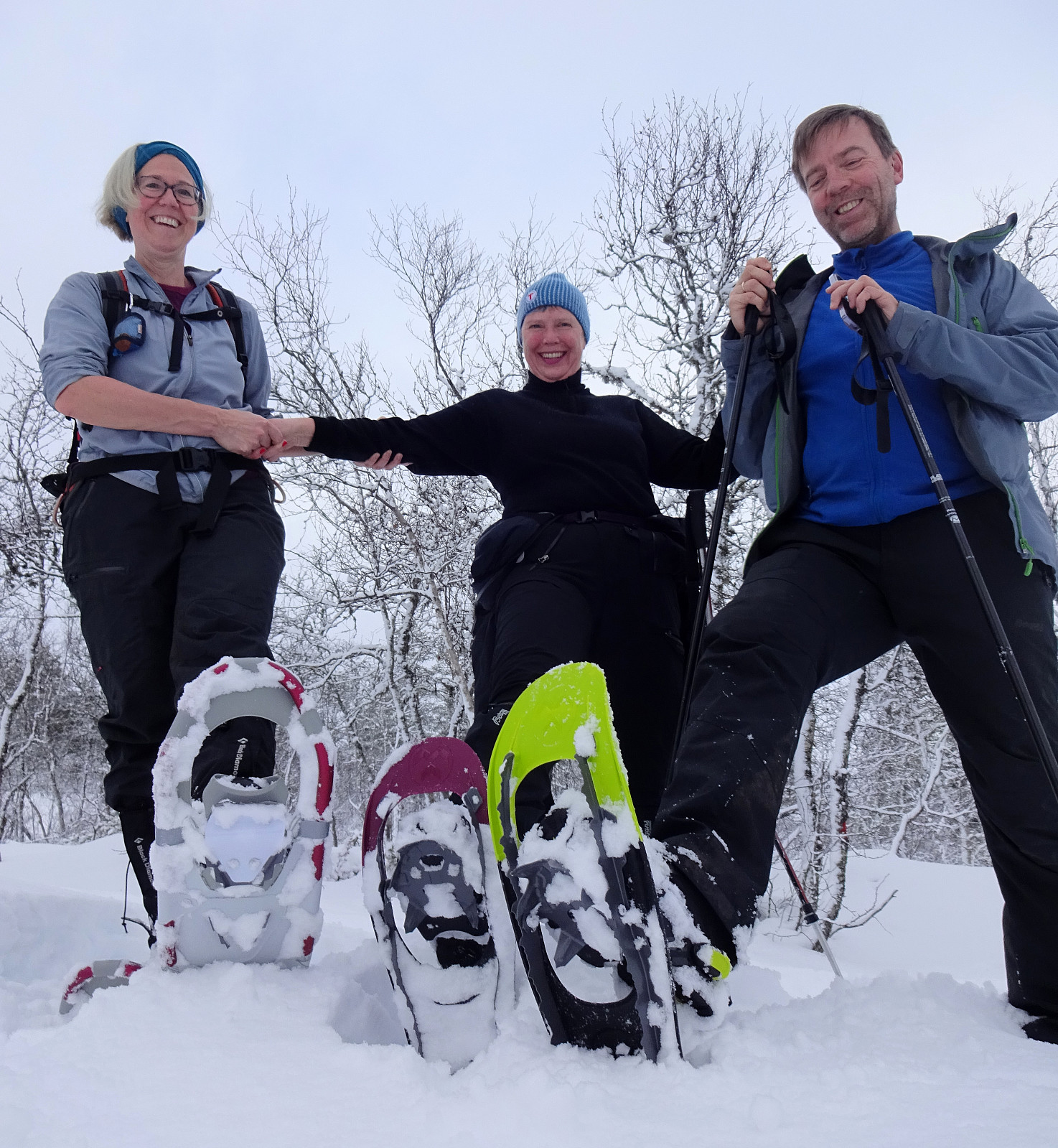 Nice excursion into the snow (with snow shoes) on the last day in the year. While the snow shoes helped a lot, it was still quite an effort through the deep snow -- definitely worth it! :-)
Selected photos are available as Google photo album .
See also the related FB-page Hiking around Bergen, Norway .
Nice excursion into the snow (with snow shoes) on the last day in the year. While the snow shoes helped a lot, it was still quite an effort through the deep snow -- definitely worth it! :-)
Selected photos are available as Google photo album .
See also the related FB-page Hiking around Bergen, Norway .
xMas hike to Fyllingsnipa
- Datum:
- 24.12.2022
- Tourcharakter:
- Wanderung
- Tourlänge:
- 1:30h
- Entfernung:
- 5,2km
 We started from the parking place at the northern end of Spelhaugen, heading for Eikelifjellet, first. Once across Eikelifjellet, we decided that it was the right day for exploring Fyllingsnipa -- a hill that we usually just pass by. To get there, we crossed over the valley in the east of Eikelifjellet a bit northwest of Tøshaugen, then ascending up to Fyllingsnipa from its south (this ascent is well possible, but a bit steep at times). From Fyllingsnipa, we then continued further northwards, passing by Nipetjørna on its western side. This brought us to a side-top of Lyngbønipa, where we had a good overview of Nipedalen and further towards the west. Thereafter, we just returned back to our car, taking a different route back (a bit further to the west).
Selected photos are available as >>>
We started from the parking place at the northern end of Spelhaugen, heading for Eikelifjellet, first. Once across Eikelifjellet, we decided that it was the right day for exploring Fyllingsnipa -- a hill that we usually just pass by. To get there, we crossed over the valley in the east of Eikelifjellet a bit northwest of Tøshaugen, then ascending up to Fyllingsnipa from its south (this ascent is well possible, but a bit steep at times). From Fyllingsnipa, we then continued further northwards, passing by Nipetjørna on its western side. This brought us to a side-top of Lyngbønipa, where we had a good overview of Nipedalen and further towards the west. Thereafter, we just returned back to our car, taking a different route back (a bit further to the west).
Selected photos are available as >>>
Random Walk in Fyllingsdalen
- Datum:
- 18.12.2022
- Tourcharakter:
- Spaziergang
- Tourlänge:
- 2:00h
- Entfernung:
- 8,4km
 Just a "random walk" in Fyllingsdalen -- no more to write! :-)
See also the related FB-page Hiking around Bergen, Norway .
Just a "random walk" in Fyllingsdalen -- no more to write! :-)
See also the related FB-page Hiking around Bergen, Norway .
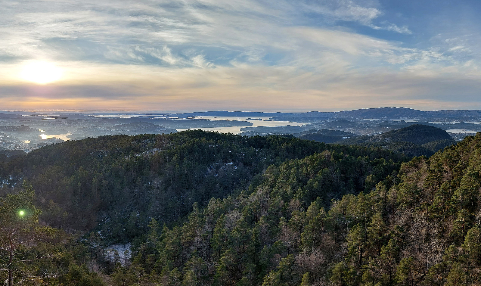
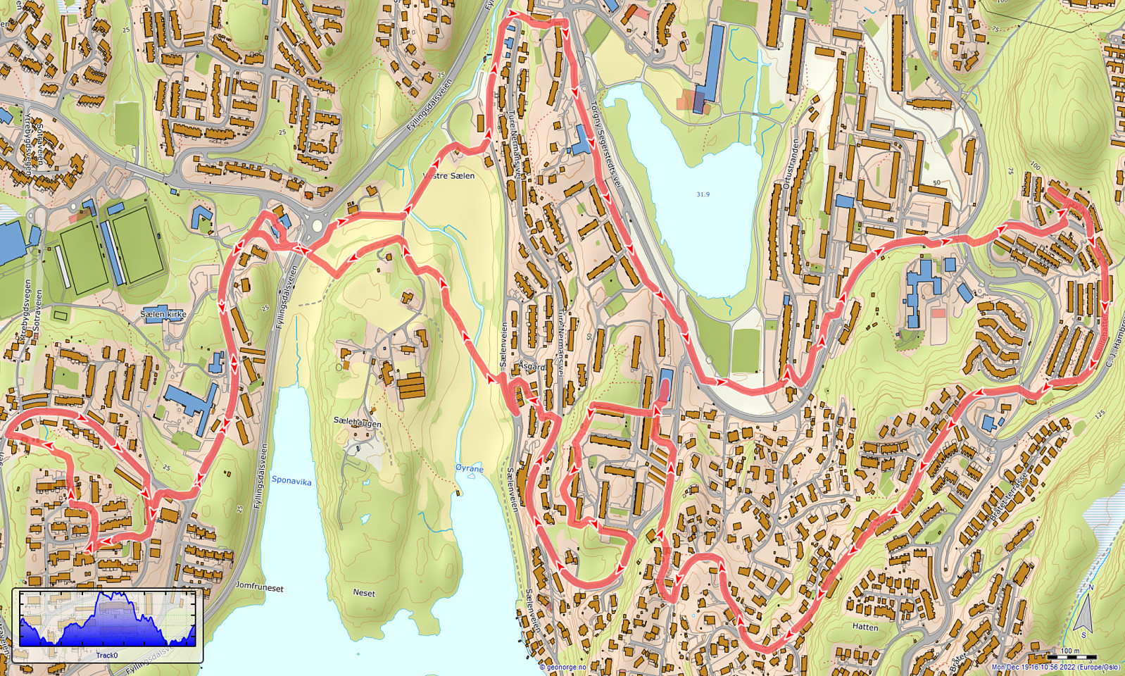
Snowy Kanadaskogen
- Datum:
- 17.12.2022
- Tourcharakter:
- Spaziergang
- Tourlänge:
- 1:30h
- Entfernung:
- 5,8km
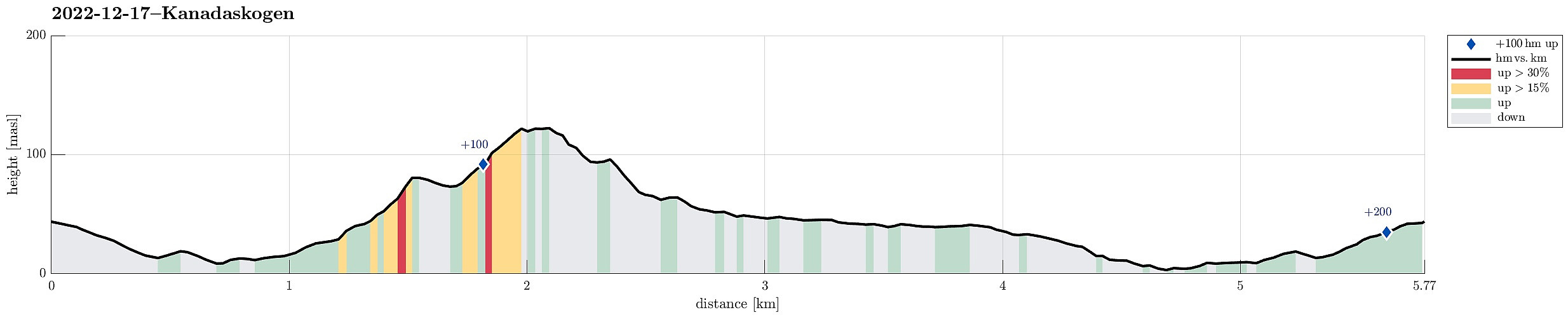 Just a nice walk into snowy Kanadaskogen, visiting Langaheia in the east of Store Krokatjørna.
Selected photos are available as Google photo album .
See also the related FB-page Hiking around Bergen, Norway .
Just a nice walk into snowy Kanadaskogen, visiting Langaheia in the east of Store Krokatjørna.
Selected photos are available as Google photo album .
See also the related FB-page Hiking around Bergen, Norway .
Møsnuken from Hegglandsdalen barneskole
- Datum:
- 03.12.2022
- Tourcharakter:
- Wanderung
- Tourlänge:
- 4:00h
- Entfernung:
- 12,0km
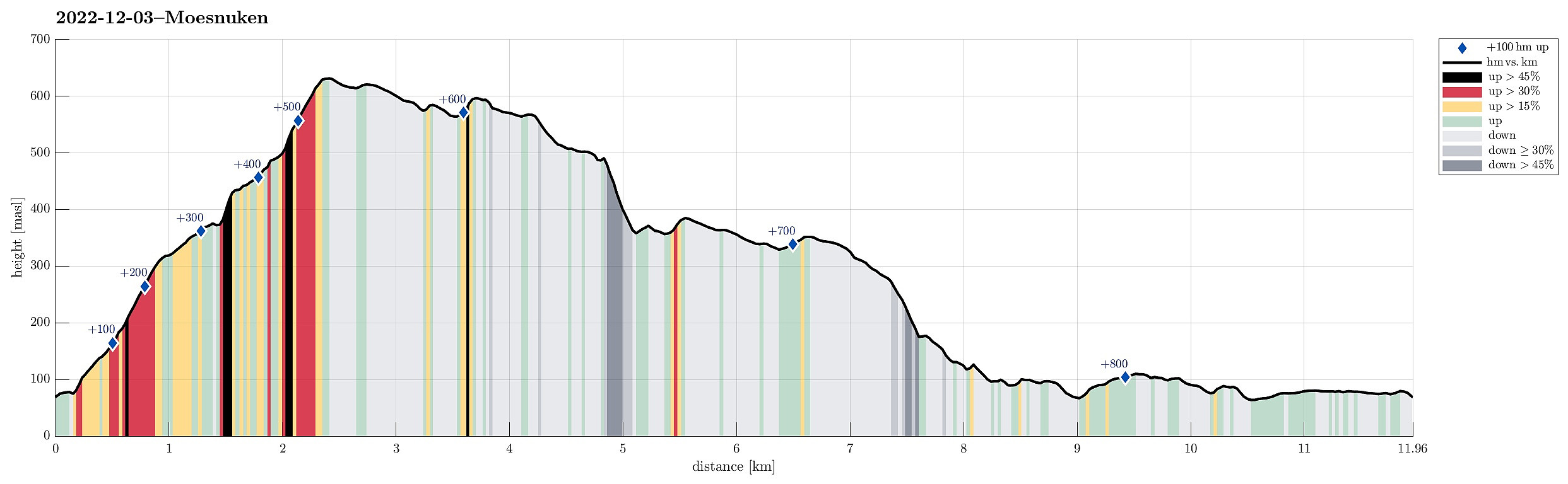 YR predicted a really nice winter day: a perfect invitation to get out! :-) Without too much comparison of all the possible nice hikes, I decided to make another attempt to ascend to Møsnuken from the southeast. I had read here on Peakbook about a trail that leads up to Tveitaberget from Hegglandsdalsvegen where it passes the primary school of Hegglandsdalen (Hegglandsdalen barneskole). And indeed there's a proper trail with a well-marked trail head next to house #528 along Hegglandsdalsvegen, which leads up along a curved ridge to Tveitaberget. According to the terrain, this trail is very steep, but just fine to step up there! :-) Once on Tveitaberget, the trail "flattens out" a little, leading then in northward direction. At about 355masl, the trail turns left to ascend steeply (for just a >>>
