Archiv - Nach Datum
Archiv - Nach Aktivität
-
Andere Tour (1)
- Kayaking (1)
-
Andere Wintertour (4)
- Schneeschuhtour (4)
-
Fahrradtour (137)
- Fahrradtour Straße (9)
- Fahrradtour gemischt (51)
-
Fußtour (740)
- Bergtour (363)
- Jogging (18)
- Spaziergang (89)
- Wanderung (270)
-
Skitour (4)
- Tourenskilauf (4)
Archiv - Nach Geografie
Peakbookfreunde


Gesammelte Listen
-
Bergen ≥ 50m pf. og ≥ 100 m.o.h.
(87/89)
 97%
97% -
Most dominating tops of the Bergen peninsula
(68/75)
90%
-
Utvalgte topper og turmål i Bergen
(316/350)
90%
-
Alle topper i Bergen
(357/398)
89%
-
Opptur Bergen
(100/113)
88%
-
De syv fjell rundt Bergen
(6/7)
85%
-
Sund ≥ 50m pf.
(14/18)
77%
-
Os ≥ 50m pf.
(25/34)
73%
-
Søyler (fastmerker) i Bergen
(68/100)
68%
-
Fjell ≥ 50m pf.
(21/32)
65%

A round west of Arna, including Stikka
- Datum:
- 27.03.2021
- Tourcharakter:
- Bergtour
- Tourlänge:
- 3:00h
- Entfernung:
- 8,5km
 With the perspective of a half-dry, half-wet day ahead of us, we decided for another hike not too far from home. This time, our goal was to explore the hills in the west of Arna and Arnavågen. We thus left Bergen towards the east, aiming for Mjeldheimskleiva, where we parked just above Kleivadalen (in the west, a bit above Arna). We left the road basically where it crosses the little stream that comes down there from the northwest (and where the power line crosses the street, also). After some only 50 meters parallel to the stream, we started our (short) ascent to Vårheia (more or less directly in northern direction). On our way up there, we deviated a little from the trail and ascended across the southern ridge of Vårheia instead (also coming by a little cabin that can be found in >>>
Stortårnet and Nilskyrkja
- Datum:
- 21.03.2021
- Tourcharakter:
- Bergtour
- Tourlänge:
- 2:00h
- Entfernung:
- 7,6km
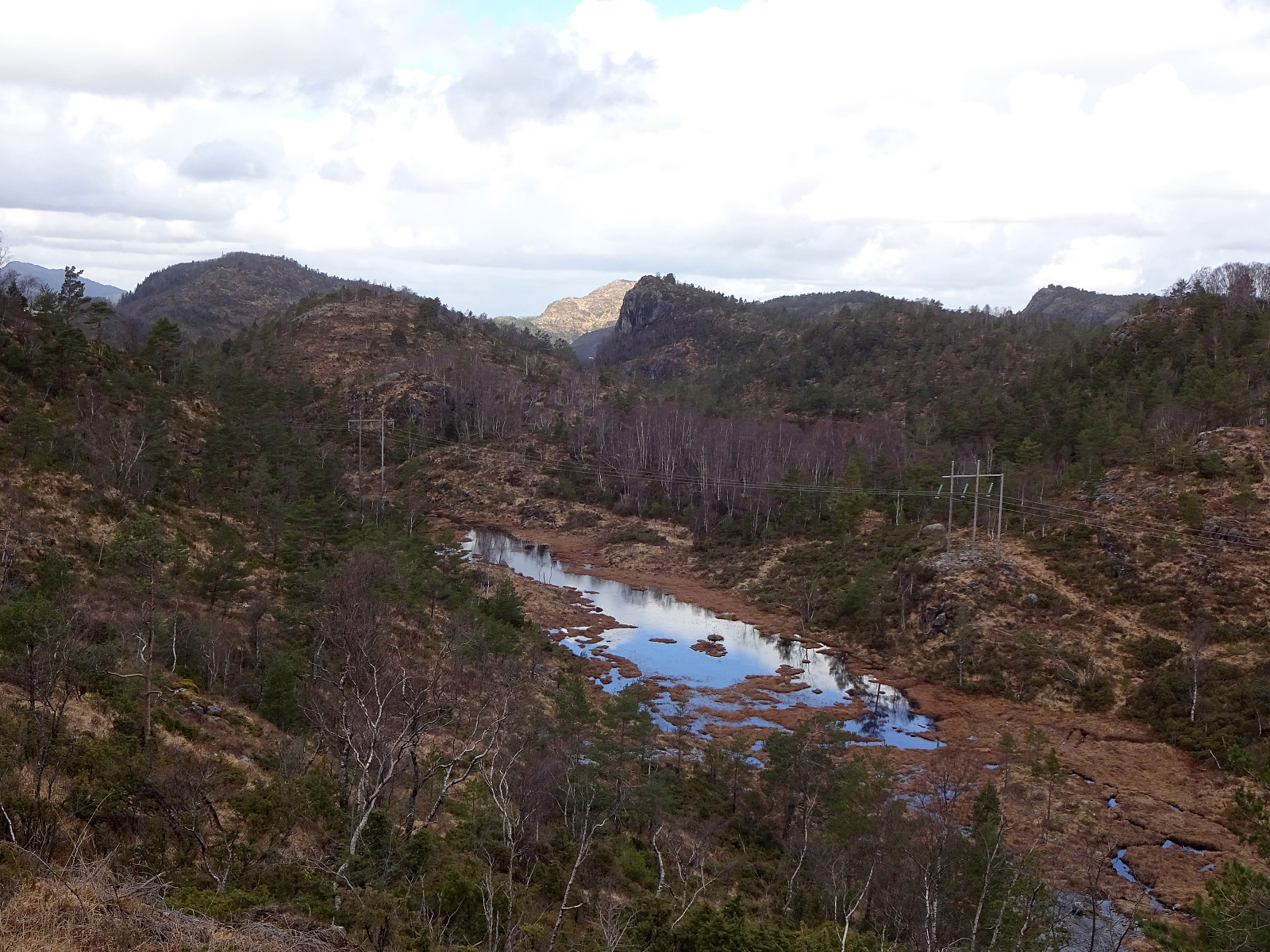
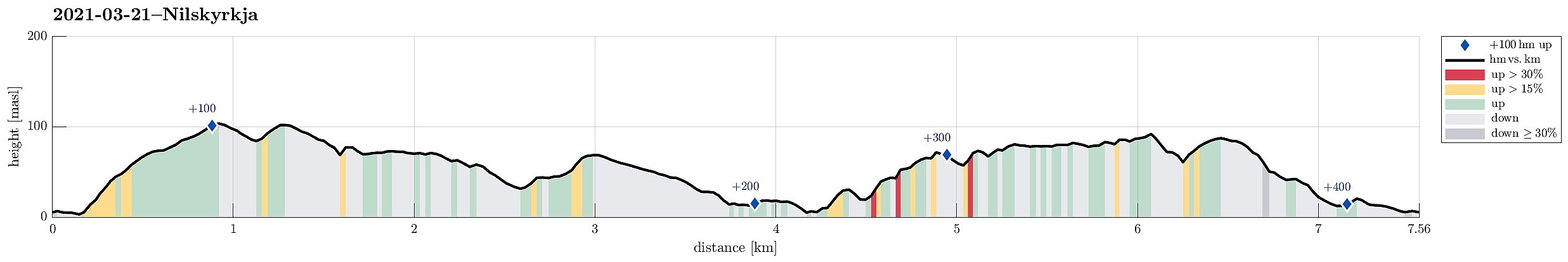 Our idea was to explore the west of Dala, south of Fjell in Øygarden. After driving westwards from Bergen, we turned south once on Sotra. Passing by Fjell, we soon arrived in Dala, where we parked next to the main road. The first (small) hiking goal of the day was Stortårnet in th southwest of Dala. After crossing a playing ground right next to Dalseidet, we started a short ascent (first without any trail). Once above 70mosl, we connected to a simple trail which then lead us to Stortårnet. Before turning back, we first explored the area a little, including the mobile sender mast in the southeast of the top (northwest of Dalatjørna). We then continued northwestwards from Stortårnet, reaching Ærhaugane soon after while walking over the ridge parallel to Trengereidpollen some 75 meters >>>
Vardetangen
- Datum:
- 14.03.2021
- Tourcharakter:
- Spaziergang
- Tourlänge:
- 1:30h
- Entfernung:
- 5,8km
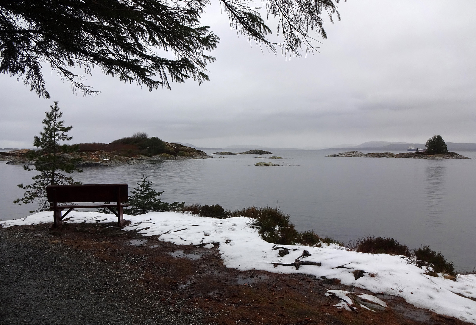 The plan for this all-in-all comparably wet day was to visit Vardetangen, i.e., Norway's western-most point, when disregarding islands. Driving north from Bergen we passed through Knarvik and continued further northwards Lindås and Mongstad. Soon after, we arrived in Austrheim and parked near Torvneset right next to Ervika. From there, it was then a short walk towards Vardetangen, where we recognized that quite a bit had changed since our last visit (the cabin, for ex., is new and also the trail there has been upgraded). After staying at Vardetangen for a short while, we continued towards Årvika along the northern shoreline. There, we used a nice wooden shelter to have a short break with some nice snacks. At last, we completed a little round back to the parking place, coming by Træsvika >>>
