Archiv - Nach Datum
Archiv - Nach Aktivität
-
Andere Tour (1)
- Kayaking (1)
-
Andere Wintertour (4)
- Schneeschuhtour (4)
-
Fahrradtour (137)
- Fahrradtour Straße (9)
- Fahrradtour gemischt (51)
-
Fußtour (740)
- Bergtour (363)
- Jogging (18)
- Spaziergang (89)
- Wanderung (270)
-
Skitour (4)
- Tourenskilauf (4)
Archiv - Nach Geografie
Peakbookfreunde


Gesammelte Listen
-
Bergen ≥ 50m pf. og ≥ 100 m.o.h.
(87/89)
 97%
97% -
Most dominating tops of the Bergen peninsula
(68/75)
90%
-
Utvalgte topper og turmål i Bergen
(316/350)
90%
-
Alle topper i Bergen
(357/398)
89%
-
Opptur Bergen
(100/113)
88%
-
De syv fjell rundt Bergen
(6/7)
85%
-
Sund ≥ 50m pf.
(14/18)
77%
-
Os ≥ 50m pf.
(25/34)
73%
-
Søyler (fastmerker) i Bergen
(68/100)
68%
-
Fjell ≥ 50m pf.
(21/32)
65%

Short excursion to Sælenvatnet
- Datum:
- 23.10.2021
- Tourcharakter:
- Bergtour
- Tourlänge:
- 0:30h
- Entfernung:
- 2,1km
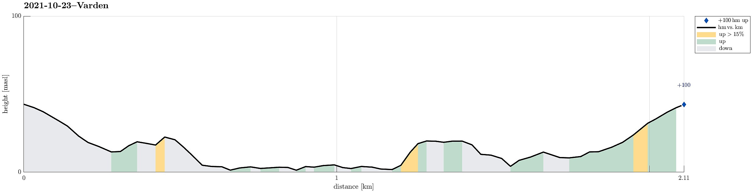 Very shot excursion to the local peninsula in Sælenvatnet to get some fresh air.
See also the related FB-page Hiking around Bergen, Norway .
Very shot excursion to the local peninsula in Sælenvatnet to get some fresh air.
See also the related FB-page Hiking around Bergen, Norway .
Klyvsnolten and Lauvhovden
- Datum:
- 19.10.2021
- Tourcharakter:
- Wanderung
- Tourlänge:
- 3:00h
- Entfernung:
- 7,8km
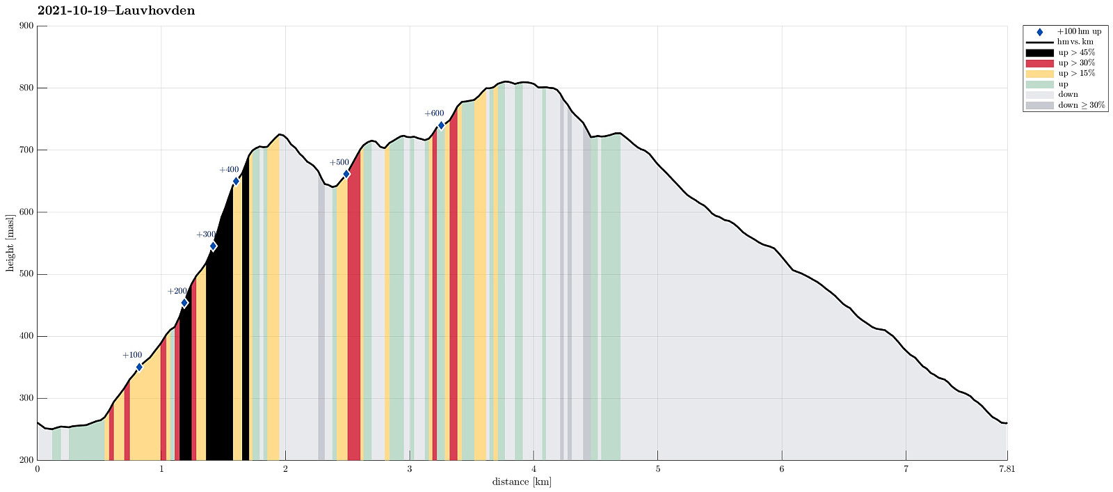 After a two days meeting at Voss, we wished to get some fresh air before darkness would set in. The weather forecast was "challenging" (loads of rain predicted), but shifted at least a little from day to day. We had not given up, but aimed at something non-extreme to account for the circumstances (limited daylight left, non-shiny weather, etc.). My dear hiking friend Harald wished to ascend Lauvhovden (and convinced me then, also). We took the car from Voss along Raundalsvegen to Klyve, where we parked near Svinåni next to a gravel road. To start our hike, we first followed Raundalsvegen a little further, passing between Øvre Klyve and Nedre Klyve, to connect to a forest road that we had seen right next to Rastalii (leading upwards into the direction of Skori and Klyvsnolten). Following >>>
Approaching Ulriken from Fyllingsdalen
- Datum:
- 17.10.2021
- Tourcharakter:
- Fahrradtour
- Tourlänge:
- 2:00h
- Entfernung:
- 29,3km
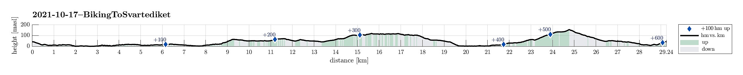 With a nice Sunday ahead of us, we decided to approach our hike by bike (eBike). Starting from Varden in Fyllingsdalen, we first biked around Bønes (along Nordåsvatnet) towards Fjøsanger. From there, we connected to the heights in the south of Storetveit kirke. Following Storetveitvegen, Hagerups vei (around Tveitevannet), and then Birkeveien, we made it to Haukelandsveien, which we followed to the northern side of th hospital. From Årstadveien we then biked along Stemmeveien and Lappen to Tarlebøveien. To focus our hike on higher grounds, we then cycled a little further along Svartediket, before we then left our bikes behind for a nice hike over Vidden . Once back from this hike, we then took the bikes out, again. To get back to Fyllingsdalen, we then chose to take the route via Melkeplassen, biking first along >>>
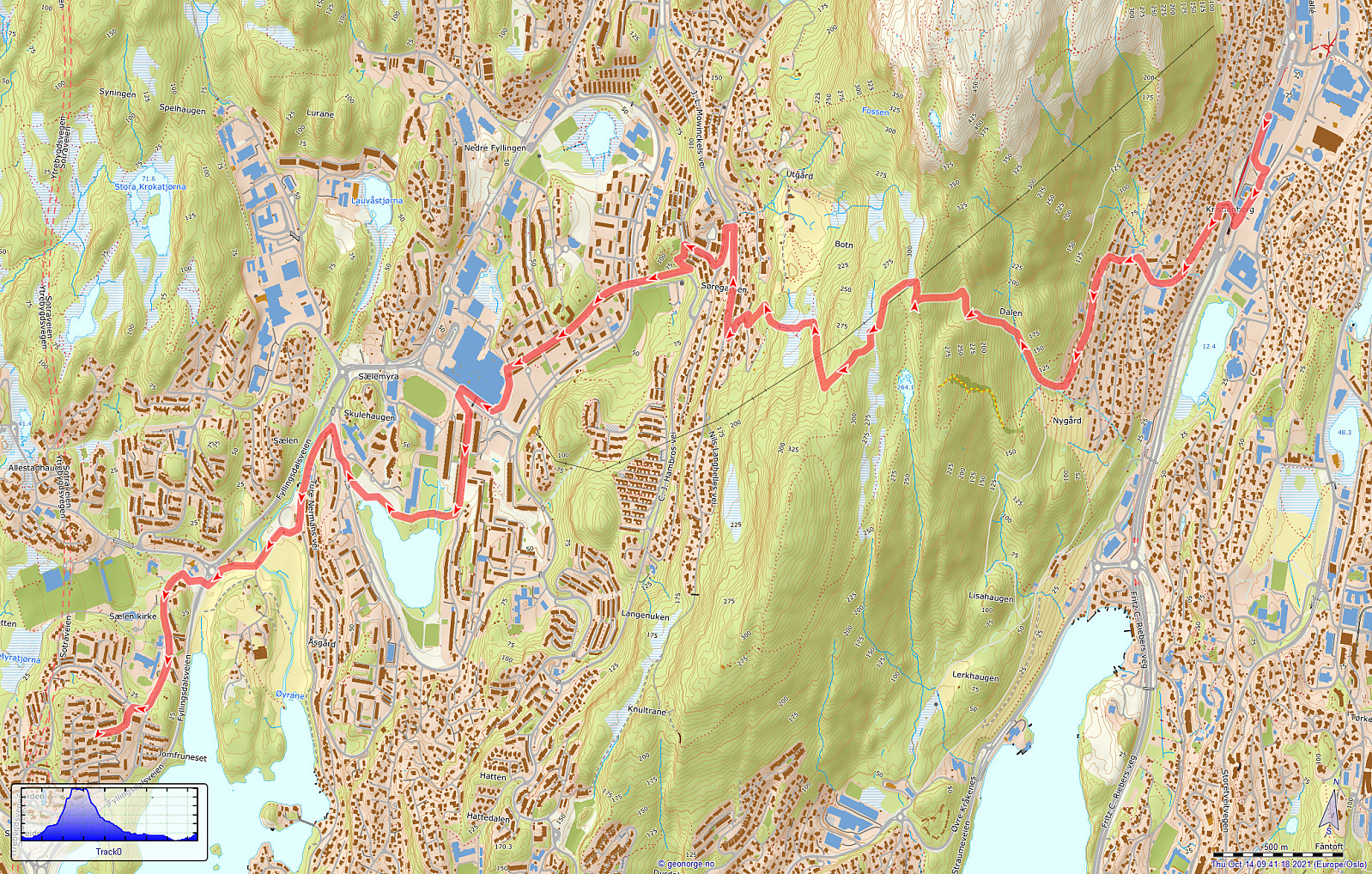
Ulriken via Ulrikseggen
- Datum:
- 17.10.2021
- Tourcharakter:
- Wanderung
- Tourlänge:
- 5:00h
- Entfernung:
- 13,9km
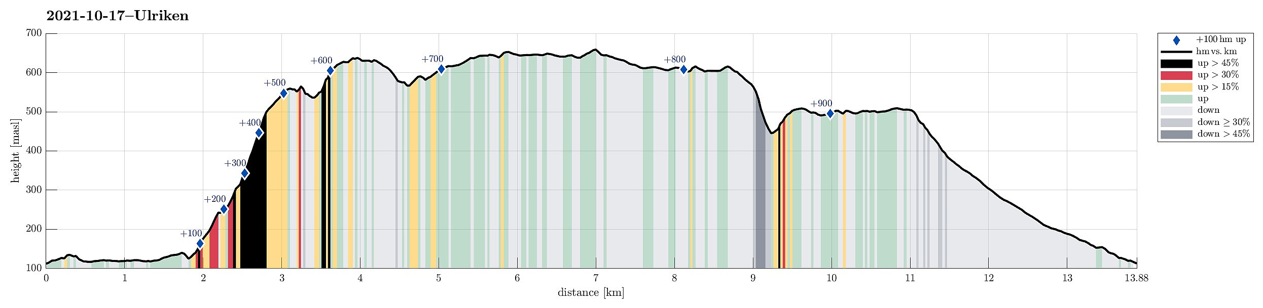 With a remarably nice Sunday ahead of us, we decided to make a round over (parts of) Vidden, starting with an ascent to Ulriken via Ulrikseggen. After first cycling to Svartediket (and a bit along it on its northern side), we started to hike not far from Koftebrotet, following the gravel road, first. This way, we passed by Hardbakkadalen and then also Isdalen, surrounding Svartediket on its eastern and then southern side. After crossing the stream that comes down Isdalen (and not following the Isdalen-trail upwards from there as one also could), we continued a little further along the gravel road until it makes a moderate turn to the right (north), leading down to Karistølen from there. It is in this turn that one can start the actual ascent via Ulrikseggen, following a trail through the forest (upwards in >>>
Crossing Gullsteinen to Fyllingsdalen
- Datum:
- 13.10.2021
- Tourcharakter:
- Bergtour
- Tourlänge:
- 2:00h
- Entfernung:
- 8,5km
 After dropping off my bike for a service I head back to Fyllingsdalen. After crossing Fjøsangerveien near the near tunnel portal (for Bybanen and cyclists), I walked up Grønestølsveien to find a way into the green above the houses. After getting to Grønnestølslien, I could not see an immediate opportunity to continue further up. Accordingly, I first followed Grønnestølslien in southern direction until it ends near a littl stream that is coming down from Løvstakken there. There, I connected to a proper trail that leads upwards; first on the eastern side of the stream. At about 160mosl, I crossed the stream and continued further upwards in western direction. After crossing over an old stone wall, I arrived at a somewhat flat spot at about 250mosl. From there, I continued further >>>
Nice hike around Hisdalsvatnet
- Datum:
- 09.10.2021
- Tourcharakter:
- Wanderung
- Tourlänge:
- 4:45h
- Entfernung:
- 10,2km
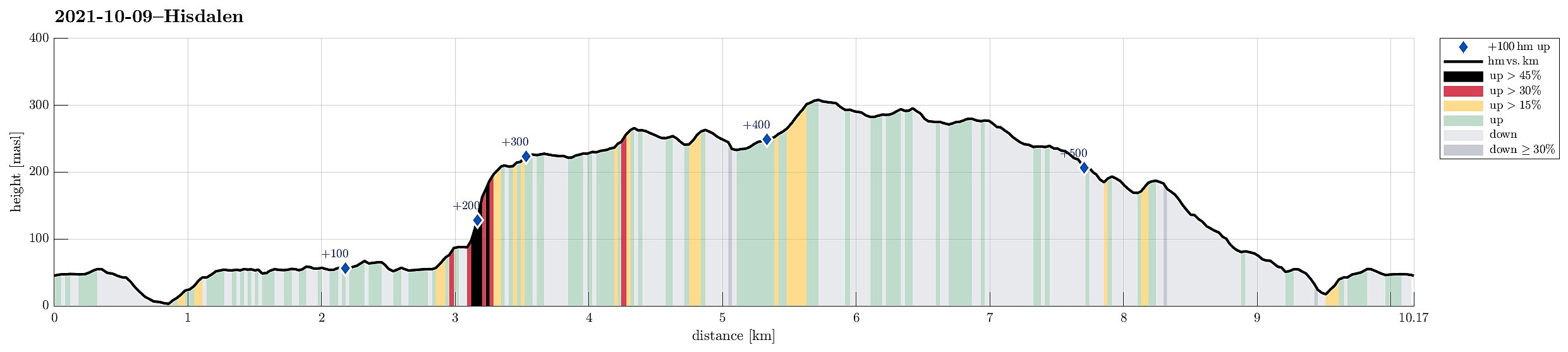 The weather forecast was OK and it looked like there was a good opportunity for a nice hike in the neighborhood. For a longer time already, the Hisdalen nature reserve had (silently) recommended itself and so we decided to pay this somewhat separated part of Bergen ("separated" in the sense that it's kind of "behind the hills of Fanafjellet") a visit. We took the car via Fana to Krokeide, where we parked next to the road (near the saddle before one drives down to the ferry terminal at Krokeide). We then walked (first along a minor road) into the direction of Austrevågen (in eastern direction), before continuing along the forest road towards the southwestern end of Hisdalsvatnet. There, our goal of crossing the stream out of Hisdalsvatnet was challenged by the large >>>
Lyderhorn (between two showers)
- Datum:
- 02.10.2021
- Tourcharakter:
- Wanderung
- Tourlänge:
- 1:30h
- Entfernung:
- 3,1km
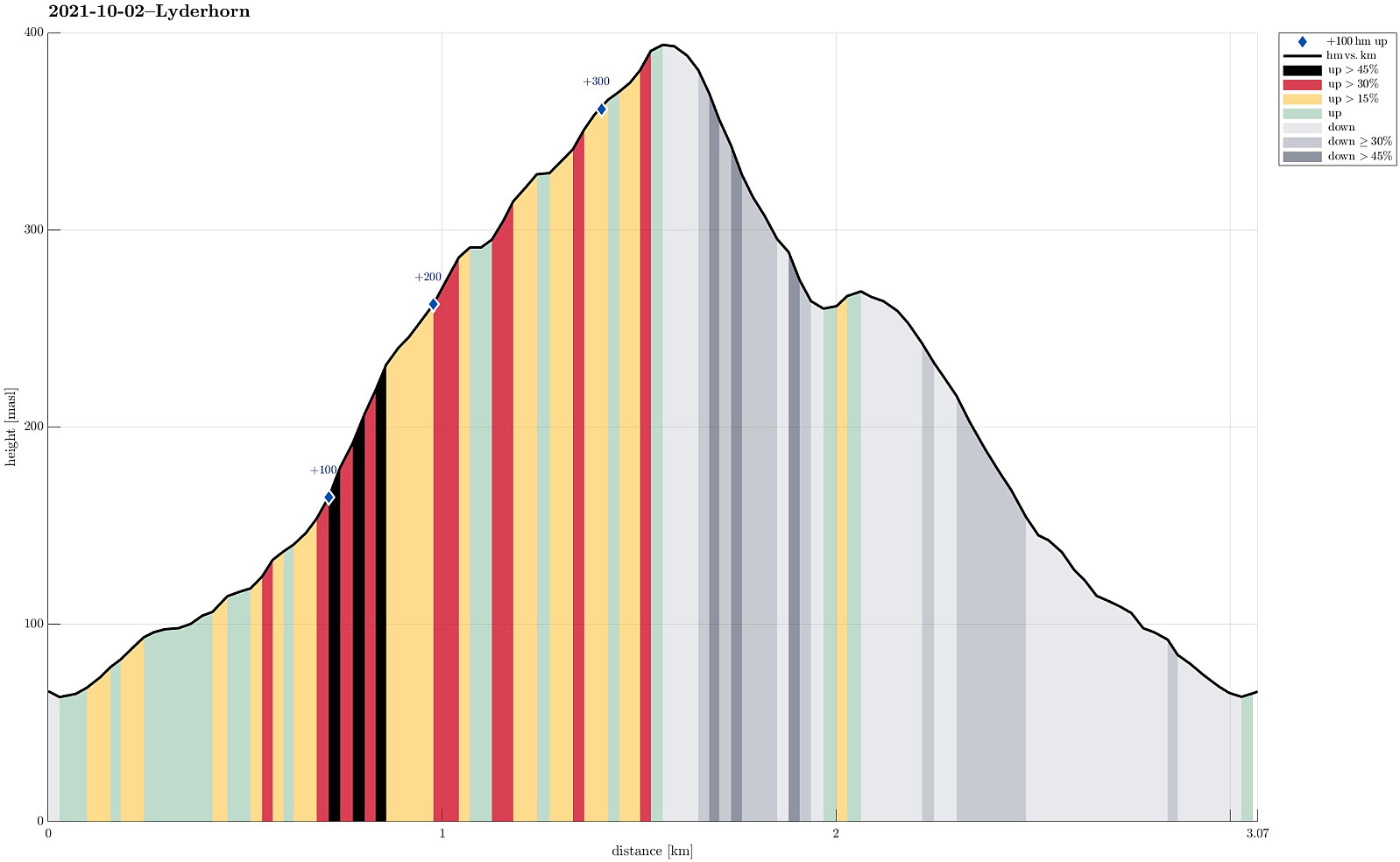 Given a rather wet day with showers coming through one after the other, we grabbed the chance of one rain break and included a short hike up to Lyderhorn (from Kjøkkelvikveien). We started along Lyderhornslien (into the direction of Olderdalen), but then chose to take the somewhat less used route up that has its trail head between Lyderhornslien 120 and 122 (some steps up, first, from between the houses). The trail is by now much better visible and it's easy to follow it upwards into the direction of Lyderhorn (first in southeastern direction, before turning left into north eastern direction). From 250mosl upwards, one can then also enjoy some nice views (mostly in western direction). From Lyderhorn, we then took the more popular route down (first in southern direction until close to Små-Lyderhorn, >>>
Short trip to Lyshovden via Bønes
- Datum:
- 26.09.2021
- Tourcharakter:
- Fahrradtour gemischt
- Tourlänge:
- 3:00h
- Entfernung:
- 14,7km
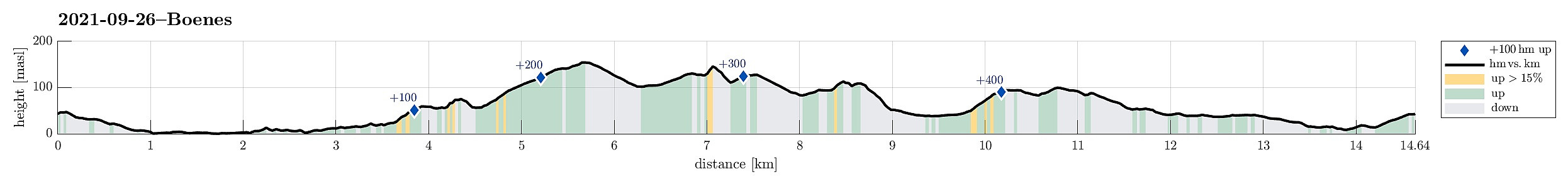 To get a bit of fresh air, I decided to pay Lyshovden a short visit. To do so, I took my eBike and first headed towards the south of Bønes (from Varden via Straume). Near Bønes kirke I took the chance to step up to Storahugen, also. From there, I passed over Bønes via Bønesskogen, connecting to C. J. Hambros vei on the other side. Once at Lyshovden, I first visited the southern hill. After completing a short round, I cycled down to the northern part of Lyshovden. Together with a friend, I then payed Nordre Lyshovden a short visit, before walking around it and getting back up to Lyshovden (then from the north). After that, it was basically to cycle home, again. In surprisingly warm autumn weather, it was nice to get some fresh air! :-)
See also the related FB-page Hiking around Bergen, Norway .
To get a bit of fresh air, I decided to pay Lyshovden a short visit. To do so, I took my eBike and first headed towards the south of Bønes (from Varden via Straume). Near Bønes kirke I took the chance to step up to Storahugen, also. From there, I passed over Bønes via Bønesskogen, connecting to C. J. Hambros vei on the other side. Once at Lyshovden, I first visited the southern hill. After completing a short round, I cycled down to the northern part of Lyshovden. Together with a friend, I then payed Nordre Lyshovden a short visit, before walking around it and getting back up to Lyshovden (then from the north). After that, it was basically to cycle home, again. In surprisingly warm autumn weather, it was nice to get some fresh air! :-)
See also the related FB-page Hiking around Bergen, Norway .
Vassenden and Store Kongshaugen
- Datum:
- 25.09.2021
- Tourcharakter:
- Bergtour
- Tourlänge:
- 3:15h
- Entfernung:
- 8,9km
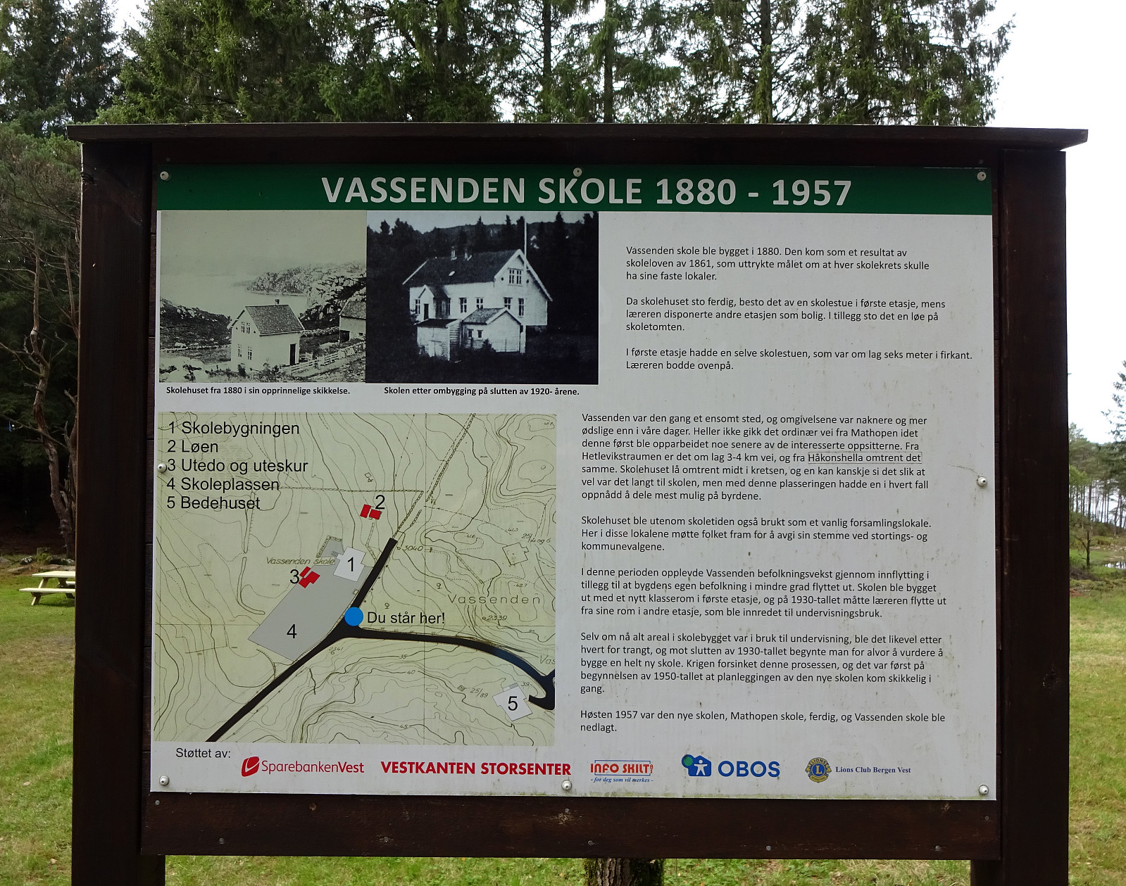 I needed some fresh air and thus decided to make a short hike through the forest in the north of Store Kongshaugen. To get there, I cycled first into the direction of Haakonsvern, before turning to the right and onto Vassendveien (near the entry to the military area at Haakonsvern). Right below Ørnahaugen, I left my bike behind and started my little forest hike. I first walked in northern direction (not directly towards Vassenden though) and found a nice trail which then brought me up to Grønabrekka. Grønabrekka has some steep sides towards the west, making it really nice to traverse it along its south-north top line. After walking over all of it, I found myself not far from Høghaugen (and not far from Storavatnet, neither). I included Høghaugen via a little loop, before heading >>>
Eggene (and back via Raudlifjellet)
- Datum:
- 19.09.2021
- Tourcharakter:
- Wanderung
- Tourlänge:
- 3:00h
- Entfernung:
- 6,9km
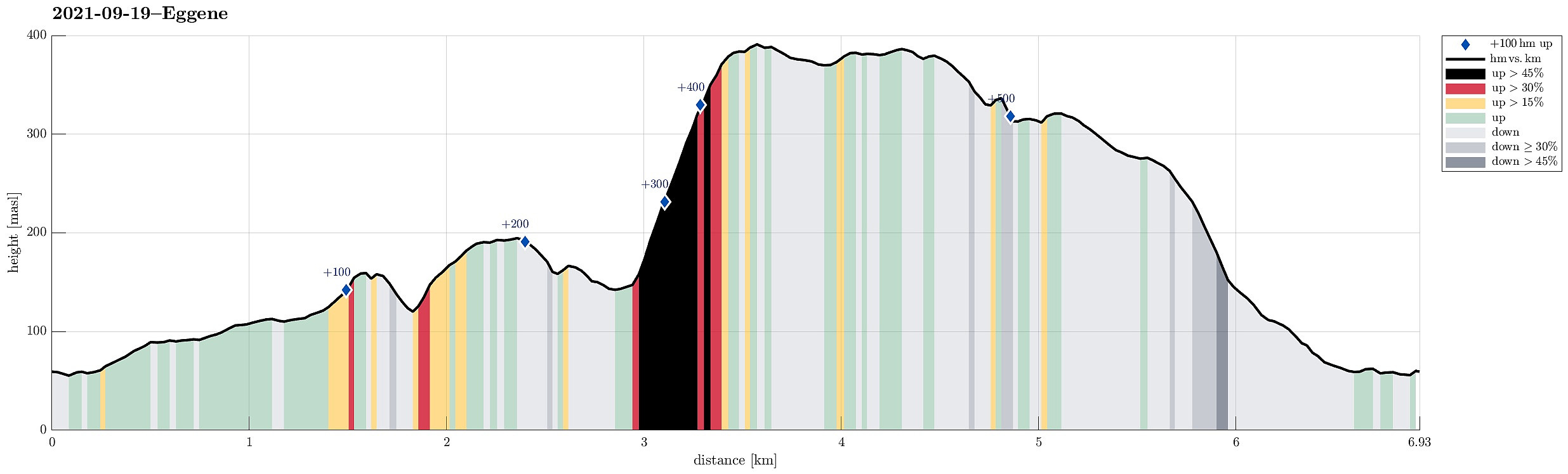 With most of the day overcast, the day's goal was an excursion into the forest in the southeast of Hausdalen. We drove first along E39 into the south of Bergen, parking not far from this road near Bahus. From there, we first walked along the road, crossing Straumen on the road's bridge, before quickly finding a tractor road that would lead us behind the houses (in northeastern direction, towards Storerinden). Once past the houses, we also left the tractor road, ascending to the gentle ridge (Storerinden). Once on the ridge, it was then straight-forward and easy to follow it (in northeastern direction). This way, one gets directly to Høghaugen (in the northwest of Breidalen) with some first nice views into Hausdalen (and down to Hauglandsvatnet). To connect further to Eggene, one needs >>>
