Archiv - Nach Datum
Archiv - Nach Aktivität
-
Andere Tour (1)
- Kayaking (1)
-
Andere Wintertour (4)
- Schneeschuhtour (4)
-
Fahrradtour (137)
- Fahrradtour Straße (9)
- Fahrradtour gemischt (51)
-
Fußtour (740)
- Bergtour (363)
- Jogging (18)
- Spaziergang (89)
- Wanderung (270)
-
Skitour (4)
- Tourenskilauf (4)
Archiv - Nach Geografie
Peakbookfreunde


Gesammelte Listen
-
Bergen ≥ 50m pf. og ≥ 100 m.o.h.
(87/89)
 97%
97% -
Most dominating tops of the Bergen peninsula
(68/75)
90%
-
Utvalgte topper og turmål i Bergen
(316/350)
90%
-
Alle topper i Bergen
(357/398)
89%
-
Opptur Bergen
(100/113)
88%
-
De syv fjell rundt Bergen
(6/7)
85%
-
Sund ≥ 50m pf.
(14/18)
77%
-
Os ≥ 50m pf.
(25/34)
73%
-
Søyler (fastmerker) i Bergen
(68/100)
68%
-
Fjell ≥ 50m pf.
(21/32)
65%

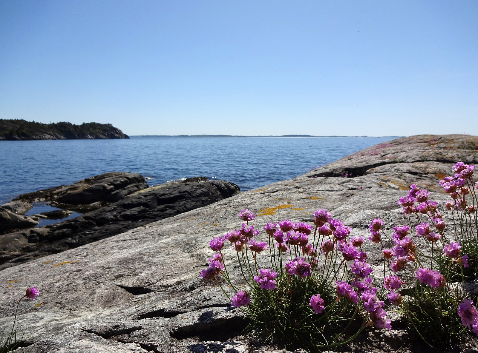
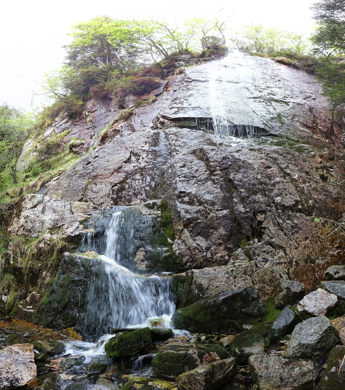
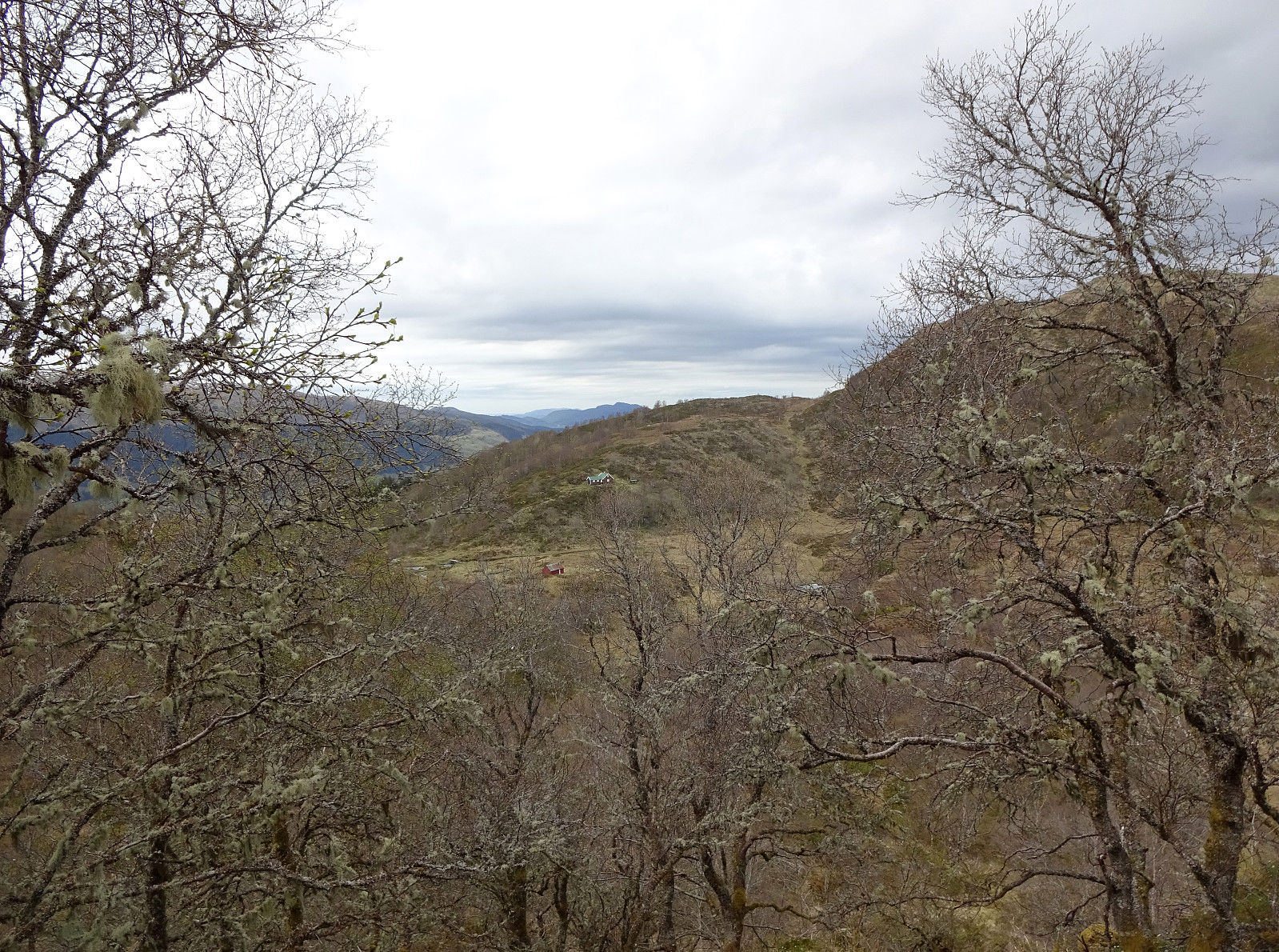
Hovlandsnuten and Etlådnefjellet
- Datum:
- 31.05.2020
- Tourcharakter:
- Wanderung
- Tourlänge:
- 5:15h
- Entfernung:
- 11,8km
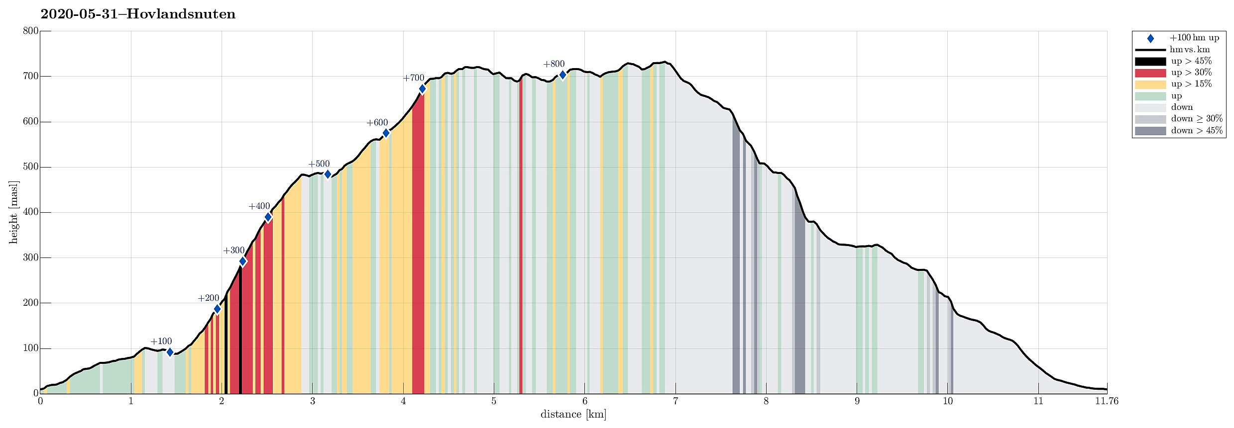 For years, we had talked about "one day" visiting Tysnes and doing some nice hike there. This weekend, with warm and sunny weather, seemed to be perfect to actually do it! :-) We drove from Bergen to Halhjem (southwest of Osøyro) and took the ferry to Vågen from there. Already this crossing of Bjørnafjorden was nice, with nice views towards south and east! Once on Tysnes, we drove first east (towards Lundegrend). There, we turned right (and south) and crossed over to the southeastern side of Tysnes (Hovland & Tveit). Our plan was to go a nice round over Hovlandsnuten, maybe the most spectacular mountain on Tysnes (not the hightest though). We parked near Tveitneset and started to hike along a forest road that extends southwards (parallel to the steep mountain side there, >>>
Nonkletten and Storavika on Korsneset
- Datum:
- 30.05.2020
- Tourcharakter:
- Bergtour
- Tourlänge:
- 2:30h
- Entfernung:
- 7,8km
 With limited time available, and a nice, warm, and sunny day, we decided to make a medium-long hike on Korsneset with nice Storavika as our main trip goal. Driving by Krokeide and continuing further onto Korsneset, we continued all the way to the junction east of Tverrhaugen, where parking is conveniently possible. Before heading towards Storvika, we wished to include Nonkletten, northeast of the parking place. We thus walked for a few meters back the road that we had come. Maybe some 200m into this, we turned left onto a proper trail, leaving in northwards direction. This trail leads nicely upwards to a nice minor hill in the west of Nonkletten. There, on a minor saddle at about 95mosl, we decided to leave the trail and head eastwards into the direction of Nonkletten. Even though one >>>
Evening Løvstakken
- Datum:
- 26.05.2020
- Tourcharakter:
- Bergtour
- Tourlänge:
- 1:30h
- Entfernung:
- 4,6km
 Spontaneously, we decided to do a quick after-work sprint up Løvstakken (the steep way). We parked near the SPAR shop "Sikthaugen" (above Sikthaugen Terrasse) and walked up the pedestrians' connection to Kirsten Flagstads vei. From there, we continued along Rosenlundveien (up to house 43), before taking the trail that ascends steeply underneath the power line in Eastern direction. At about 350mosl, the steepest part of the trail starts (roughly in Northern direction). A bit more the 50 meters higher, one comes out and can enjoy some nice views over Fyllingsdalen. From there, it's then "just" following the trail all to the top of Fyllingsdalen. Definitely a nice alternative of an ascent to Løvstakken! From the top, we then followed the Northern ridge down (into the >>>
Tåkenuten and Kråkenos
- Datum:
- 23.05.2020
- Tourcharakter:
- Wanderung
- Tourlänge:
- 6:15h
- Entfernung:
- 13,4km
 Weighing the weather forecast with our wish to make a nice hike, we ended up with Kråkenos as our hiking goal. While this mountain is also well accessible from its eastern side (from Bru near Strandebarm at Hardangerfjorden), we decided to approach it from its western side, i.e., from Øvre Hålandsdalen. To get there, we drove from Bergen first along E16 into the direction of Voss, then along road 49 into the direction of Kvamskogen, before then continuing along road 48 to Eikelandsosen and from there further towards Holdhus a few kilometers in the east of Eikelandsosen. Near Holdhus one needs to take a sharp turn to the left (north) onto an old and narrow road that leads into Øvre Hålandsdalen (after first passing between Gjønavatnet in the north and Skogseidvatnet in the south). >>>
Tunesfjellet and Skåldalsfjellet
- Datum:
- 21.05.2020
- Tourcharakter:
- Wanderung
- Tourlänge:
- 4:30h
- Entfernung:
- 12,2km
 One could say that this hike is a logical continuation of our small research project Gullfjellet from the north, Sørfjorden . :-) We drove from Bergen to Arna and then through the tunnel under Ådnanipa (E16), before taking the very first exit ("Takvam") and turning back along the old road (Tunesvegen) into the direction of Tunes. At Tunestveit, only a few meters from the E16-exit, we parked along the road. We then crossed under E16 (right where it comes out of the tunnel under Ådnanipa, crossing over Tveitaelva there) and continued on an old forest road into the direction of Åsen. All the terrain is very steep there and most parts will not provide any opportunity to continue all the way up. Our map study, however, had suggested that ascending to Åsen on the very eastern side >>>
Gravdalsfjellet from Betanien
- Datum:
- 18.05.2020
- Tourcharakter:
- Bergtour
- Tourlänge:
- 1:00h
- Entfernung:
- 3,7km
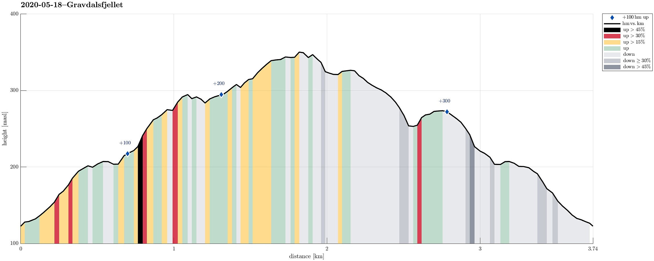 To get some fresh air, we decided to make a short hike up Gravdalsfjellet. We started at Betanien near Vestlund in Fyllingsdalen, Bergen, and head first northwards before then turning left (westwards) into the direction of Gravdalsfjellet. Right after passing by Brattheim, we took the stairs up into the direction of Viggohytten. As soon as we came out on top, however, we made a short detour to visit Kjerringen på Nipen, from where one can enjoy excellent views over Fyllingsdalen. We then headed back to the trail and up to Viggohytten before we continued further upwards to visit near Gravdalsfjellet. From there, we took another trail down (in the west of Gravdalsfjellet. After this short detour, we connected back with the trail that we had taken up near Brattheim. From there, it was >>>
Herlandsfjellet from Herland
- Datum:
- 10.05.2020
- Tourcharakter:
- Wanderung
- Tourlänge:
- 3:45h
- Entfernung:
- 11,0km
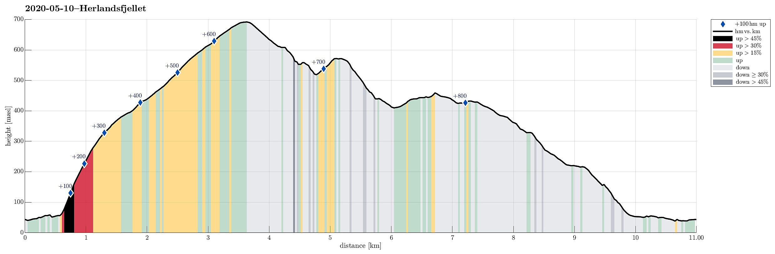 For a longer time already, we had the idea to try Herlandsfjellet from its northern side. When studying the available maps, it's not so obvious, how this should be done (as no trails are to be seen from the north). After some investigation, we were left with two choices that we deemed possible: going up from Ytre Songstad (along a narrow ridge that is very steep on either side) or going up from Herland, where the bridge to Osterøy is anchored (a less pronounced while also steep ridge). Eventually, looking at satellite images suggested that the eastern variant (from Ytre Songstad) would be through a dense looking forest, while the western variant (from Herland) appeared to have less dense standing trees. Since we were unsure how difficult it would be to ascend through a relatively dense >>>
Hamrefjellet
- Datum:
- 09.05.2020
- Tourcharakter:
- Bergtour
- Tourlänge:
- 2:00h
- Entfernung:
- 7,6km
 Between two visits of shops, we wished to get some fresh air. Since we were close already, we decided to go a quick round around Hamrefjellet. Since we wished to start with Tornetfjellet, we drove into the direction of Smørås (just to find out that parking is non-trivial there -- clearly, those who live there do not like hikers to park up there). We thus parked quite a bit longer down along Smøråsvegen and walked back up from there. We then ascended Torneberget from Smøråsvegen (only a few meters up), before continuing along a nice trail that stretches over the heights into southern direction (towards Hamrefjellet). Passing by Myrasmettet, we ascended Vardane (also only a few meters up). We next thought to take a look at Vallastølen. Instead of walking "down" to Militærvegen, >>>
