Archiv - Nach Datum
Archiv - Nach Aktivität
-
Andere Tour (1)
- Kayaking (1)
-
Andere Wintertour (4)
- Schneeschuhtour (4)
-
Fahrradtour (137)
- Fahrradtour Straße (9)
- Fahrradtour gemischt (51)
-
Fußtour (740)
- Bergtour (363)
- Jogging (18)
- Spaziergang (89)
- Wanderung (270)
-
Skitour (4)
- Tourenskilauf (4)
Archiv - Nach Geografie
Peakbookfreunde


Gesammelte Listen
-
Bergen ≥ 50m pf. og ≥ 100 m.o.h.
(87/89)
 97%
97% -
Most dominating tops of the Bergen peninsula
(68/75)
90%
-
Utvalgte topper og turmål i Bergen
(316/350)
90%
-
Alle topper i Bergen
(357/398)
89%
-
Opptur Bergen
(100/113)
88%
-
De syv fjell rundt Bergen
(6/7)
85%
-
Sund ≥ 50m pf.
(14/18)
77%
-
Os ≥ 50m pf.
(25/34)
73%
-
Søyler (fastmerker) i Bergen
(68/100)
68%
-
Fjell ≥ 50m pf.
(21/32)
65%

Gulltjørna via Trengereidhotten from Risnes
- Datum:
- 29.06.2019
- Tourcharakter:
- Bergtour
- Tourlänge:
- 5:45h
- Entfernung:
- 8,3km
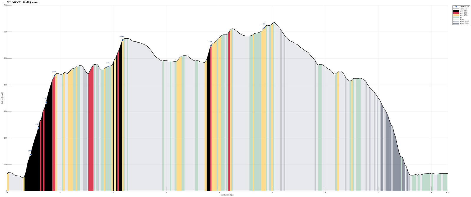 We left Bergen in eastern direction on E16 (into the direction of Voss), leaving the main road just before Romslo, changing to the old road that brings one through Romslo to Risnes. We found a suitable place to park in Risnes and started our hike from there.
Our first goal was Krånuken, to get up onto the heights north of Gullfjellet. For years, already, I had looked at this idea of ascending Trengereidhotten from the north, but hesitated (now I know that this was for good reasons!). This time, we finally decided to give it an attempt. We chose Sverinden, leading up to Krånuken, as the line and started from the street, where it passes under a short tunnel at the northern end of Sverinden. Immediately, our expectations were confirmed: the ascent over the ridge of Sverinden is very steep, >>>
We left Bergen in eastern direction on E16 (into the direction of Voss), leaving the main road just before Romslo, changing to the old road that brings one through Romslo to Risnes. We found a suitable place to park in Risnes and started our hike from there.
Our first goal was Krånuken, to get up onto the heights north of Gullfjellet. For years, already, I had looked at this idea of ascending Trengereidhotten from the north, but hesitated (now I know that this was for good reasons!). This time, we finally decided to give it an attempt. We chose Sverinden, leading up to Krånuken, as the line and started from the street, where it passes under a short tunnel at the northern end of Sverinden. Immediately, our expectations were confirmed: the ascent over the ridge of Sverinden is very steep, >>>
Stendörren
- Datum:
- 18.06.2019
- Tourcharakter:
- Spaziergang
- Tourlänge:
- 2:30h
- Entfernung:
- 7,9km
 After a good workshop day in Nyköping, we had the chance to see Stendörrens naturreservat in the evening. Walking along the very well marked trails, many photo opportunities emerged! :-) The complex intermingling of the forest, several islands (many of which small), and the sea makes this place (as well as others along the Swedish coast!) very attractive.
Selected photos are available as Google photo album .
See also the related FB-page Hiking around Bergen, Norway .
Stendörren is further described at a web page of Länsstyrelsen Södermanland .
After a good workshop day in Nyköping, we had the chance to see Stendörrens naturreservat in the evening. Walking along the very well marked trails, many photo opportunities emerged! :-) The complex intermingling of the forest, several islands (many of which small), and the sea makes this place (as well as others along the Swedish coast!) very attractive.
Selected photos are available as Google photo album .
See also the related FB-page Hiking around Bergen, Norway .
Stendörren is further described at a web page of Länsstyrelsen Södermanland .
Skorseteggi and Kolingseggi
- Datum:
- 15.06.2019
- Tourcharakter:
- Bergtour
- Tourlänge:
- 4:00h
- Entfernung:
- 10,7km
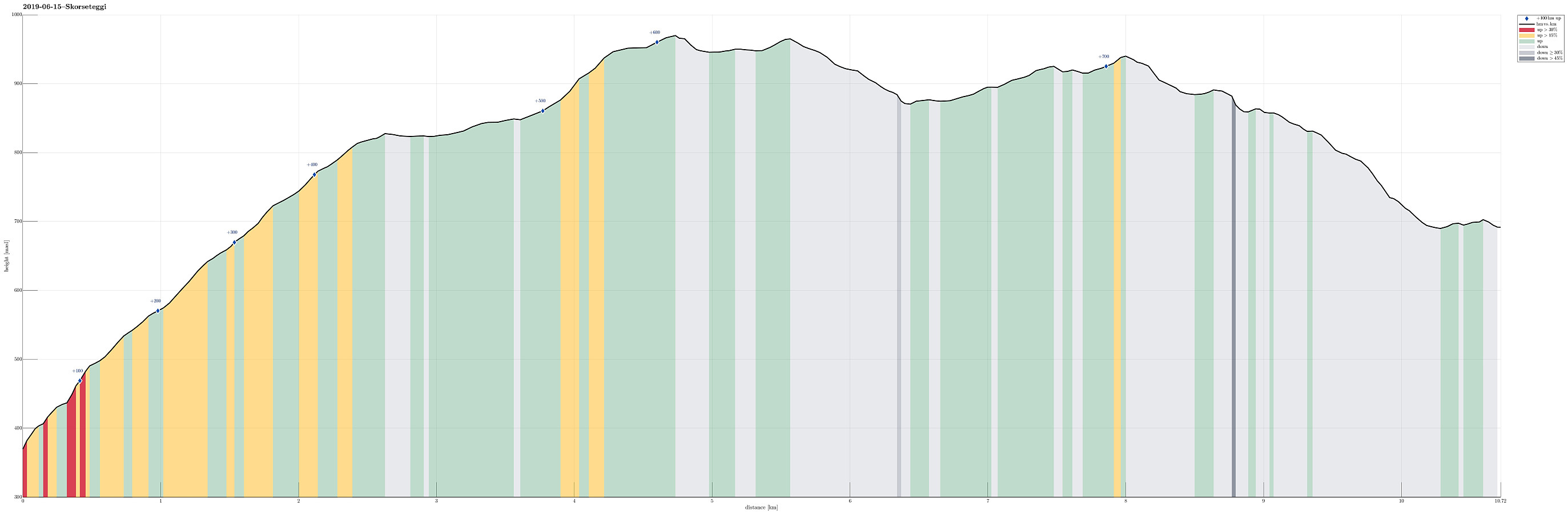 We used the advantage of having two cars this time and parked one of them near Liaset, north of Lemme and east of Lønavatnet (all near Voss). Note that you have to pay a small fee for driving the last stretch up to Liaset (NOK 20, I think), so having some coins ready may help. We then drove back to the northern side of this mountain ridge and parked near Øyjordi (near Oppheimsvatnet), where a nicely marked trail starts (back to Lemme). Following this easy-to-find trail, we ascended swiftly to Øyjordsstølen, first, and from there then further into the direction of Skorseteggi, passing by Øyjordtjørni (and Flatafjellet behind it) on our way up. Enjoying a perfect hiking day with lots of sunshine and pleasant temperatures, we spent some bonus time on the top of Skorseteggi -- simply >>>
