Archiv - Nach Datum
Archiv - Nach Aktivität
-
Andere Tour (1)
- Kayaking (1)
-
Andere Wintertour (4)
- Schneeschuhtour (4)
-
Fahrradtour (137)
- Fahrradtour Straße (9)
- Fahrradtour gemischt (51)
-
Fußtour (740)
- Bergtour (363)
- Jogging (18)
- Spaziergang (89)
- Wanderung (270)
-
Skitour (4)
- Tourenskilauf (4)
Archiv - Nach Geografie
Peakbookfreunde


Gesammelte Listen
-
Bergen ≥ 50m pf. og ≥ 100 m.o.h.
(87/89)
 97%
97% -
Most dominating tops of the Bergen peninsula
(68/75)
90%
-
Utvalgte topper og turmål i Bergen
(316/350)
90%
-
Alle topper i Bergen
(357/398)
89%
-
Opptur Bergen
(100/113)
88%
-
De syv fjell rundt Bergen
(6/7)
85%
-
Sund ≥ 50m pf.
(14/18)
77%
-
Os ≥ 50m pf.
(25/34)
73%
-
Søyler (fastmerker) i Bergen
(68/100)
68%
-
Fjell ≥ 50m pf.
(21/32)
65%

Around Gåssandvatnet
- Datum:
- 28.12.2016
- Tourcharakter:
- Wanderung
- Tourlänge:
- 3:00h
- Entfernung:
- 10,1km
 After first visiting a shop in Søfteland (along E39 from Bergen to Os), we wanted to make a hike around Gåssandvatnet. We parked our car right next to the Søfteland school and started to walk from there. First, we followed a little path, which leads southwards (parallel to E39, but not right at it, fortunately).
Our plan was to cross Storestraumen across a little bridge, which we had seen before on the map. Once we got there, however, we met an unexpected challenge: The bridge belongs to the private place on the other side of Storestraumen and it is locked with a door that is also secured by an alarm. Since we were motivated to not give up at once, we organized the telephone number of the owner of the bridge from a friendly neighbor and then called. Luckily we were then enabled to cross >>>
After first visiting a shop in Søfteland (along E39 from Bergen to Os), we wanted to make a hike around Gåssandvatnet. We parked our car right next to the Søfteland school and started to walk from there. First, we followed a little path, which leads southwards (parallel to E39, but not right at it, fortunately).
Our plan was to cross Storestraumen across a little bridge, which we had seen before on the map. Once we got there, however, we met an unexpected challenge: The bridge belongs to the private place on the other side of Storestraumen and it is locked with a door that is also secured by an alarm. Since we were motivated to not give up at once, we organized the telephone number of the owner of the bridge from a friendly neighbor and then called. Luckily we were then enabled to cross >>>
Ljosvollsvarden
- Datum:
- 27.12.2016
- Tourcharakter:
- Bergtour
- Tourlänge:
- 1:00h
- Entfernung:
- 3,5km
 We left home in slight rain and no indication that the weather should clear up any time soon, driving via Midtun to the street, which leads up to Totland (road #183). We passed by Myrdalsvatnet and continued further upwards. Before we came to Fjellbirkeland, we parked right next to the road (at about 5.401°E/60.305°N).
From there, we took a forest road, which leads steadily upwards (in southwestern direction). Soon the light rain turned into light snowfall (a bit nicer, after all). Once we came up and the terrain became comparably flat, we left the forest road and entered the forest in order to find a connection to the "top" of Ljosvollsvarden.
We started (in the thick forest!) in southwestern direction, before we reached the end of the forest. There, we turned right (now in >>>
We left home in slight rain and no indication that the weather should clear up any time soon, driving via Midtun to the street, which leads up to Totland (road #183). We passed by Myrdalsvatnet and continued further upwards. Before we came to Fjellbirkeland, we parked right next to the road (at about 5.401°E/60.305°N).
From there, we took a forest road, which leads steadily upwards (in southwestern direction). Soon the light rain turned into light snowfall (a bit nicer, after all). Once we came up and the terrain became comparably flat, we left the forest road and entered the forest in order to find a connection to the "top" of Ljosvollsvarden.
We started (in the thick forest!) in southwestern direction, before we reached the end of the forest. There, we turned right (now in >>>
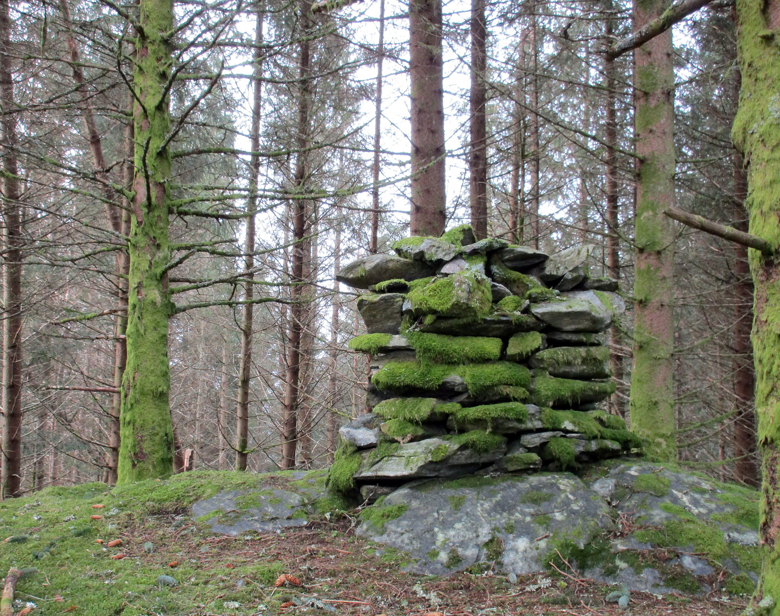
Storm-beaten Lyderhorn interruptus
- Datum:
- 26.12.2016
- Tourcharakter:
- Bergtour
- Tourlänge:
- 1:00h
- Entfernung:
- 2,3km
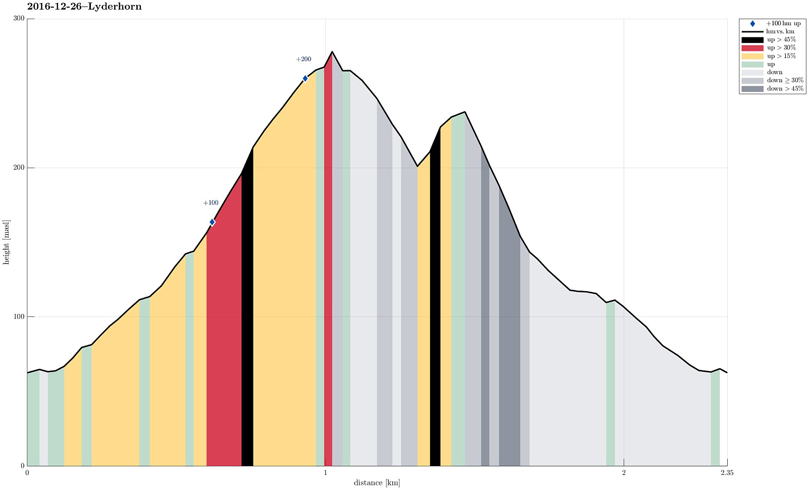 We parked near Kjøkkelvik school on the western side of Lyderhorn and started to go from there (along Lyderhornslien). Once in Olderdalen, we started to ascend along the well-used path (upwards in southeastern direction).
Near Små-Lyderhorn, at about 275mosl, we started to feel the strong winds, which also were announced all along the southwestern coast of Norway. Only minutes later, we concluded that the winds were too strong for continuing further up along the outer (southern) side of Lyderhorn. Instead, we decided to turn around, descend into Olderdalen (instead of taking the same path back, which we had taken up), and make an attempt to connect to this other path between Lyderhornslien and Lyderhorn (a bit further north).
In principle, everything went as intended, but it must be noted >>>
We parked near Kjøkkelvik school on the western side of Lyderhorn and started to go from there (along Lyderhornslien). Once in Olderdalen, we started to ascend along the well-used path (upwards in southeastern direction).
Near Små-Lyderhorn, at about 275mosl, we started to feel the strong winds, which also were announced all along the southwestern coast of Norway. Only minutes later, we concluded that the winds were too strong for continuing further up along the outer (southern) side of Lyderhorn. Instead, we decided to turn around, descend into Olderdalen (instead of taking the same path back, which we had taken up), and make an attempt to connect to this other path between Lyderhornslien and Lyderhorn (a bit further north).
In principle, everything went as intended, but it must be noted >>>
Løvstakken
- Datum:
- 23.12.2016
- Tourcharakter:
- Bergtour
- Tourlänge:
- 1:15h
- Entfernung:
- 3,5km
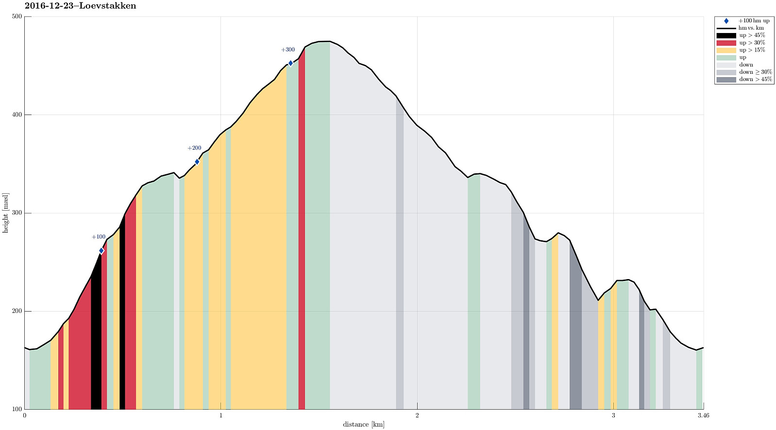 We parked at the small parking place right above Litlavanet (along road Krohnegården). We then stepped upwards in northeastern direction (towards Ravnefjellet) and came to the small saddle between Ravnefjellet and Løvstakken soon. From there, we turned "back" towards Løvstakken (mostly in southern direction, then). Soon later, we came to the top of Løvstakken. We returned basically along the same route. Almost all the way back, a little excursion (to the upper parts of the little waterfall down there "in the western corner of Løvstakken") was added---mostly to get an idea, whether one could ascend to Løvstakken also from there "diritissima" (it seems so---to be explored!).
See also the related FB-page Hiking around Bergen, Norway .
Web page WestCoastPeaks.com provides useful information about Løvstakken .
We parked at the small parking place right above Litlavanet (along road Krohnegården). We then stepped upwards in northeastern direction (towards Ravnefjellet) and came to the small saddle between Ravnefjellet and Løvstakken soon. From there, we turned "back" towards Løvstakken (mostly in southern direction, then). Soon later, we came to the top of Løvstakken. We returned basically along the same route. Almost all the way back, a little excursion (to the upper parts of the little waterfall down there "in the western corner of Løvstakken") was added---mostly to get an idea, whether one could ascend to Løvstakken also from there "diritissima" (it seems so---to be explored!).
See also the related FB-page Hiking around Bergen, Norway .
Web page WestCoastPeaks.com provides useful information about Løvstakken .
Signalen
- Datum:
- 18.12.2016
- Tourcharakter:
- Bergtour
- Tourlänge:
- 0:45h
- Entfernung:
- 2,7km
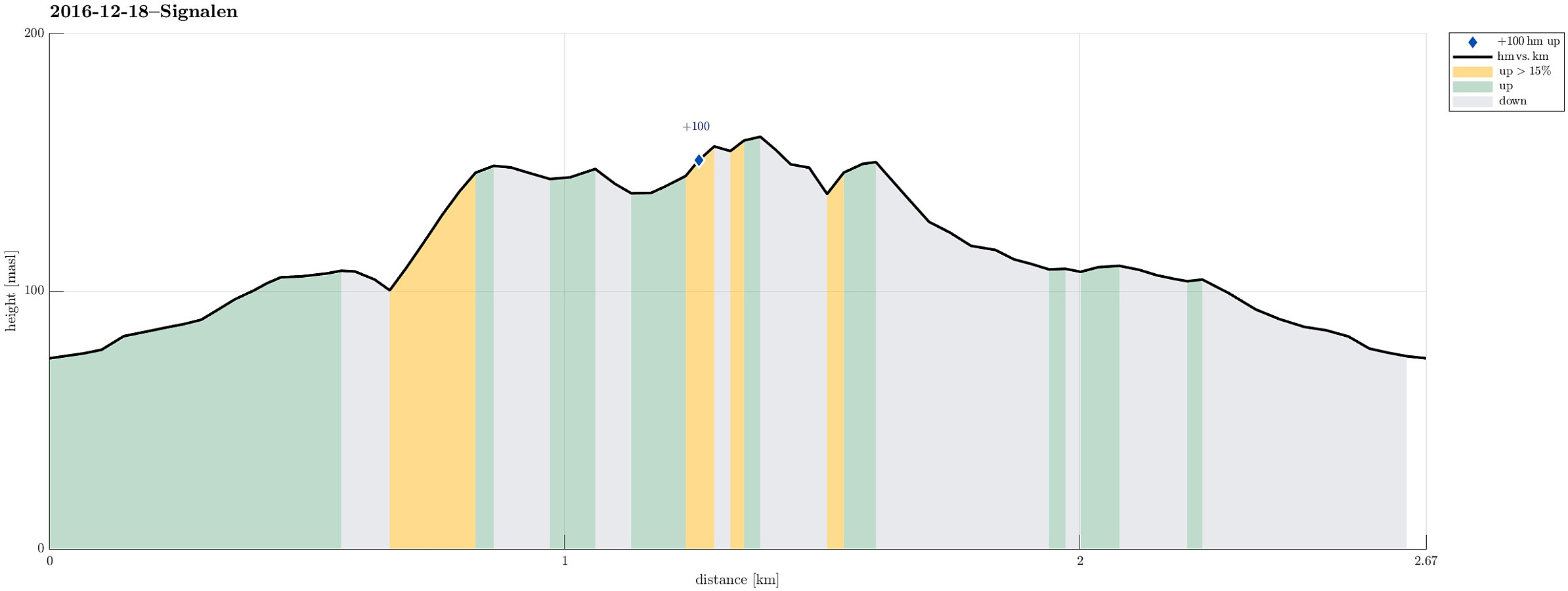 We drove west from Bergen to Sotra and then further to Fjell, where we took the road 559 into the direction of Møvik. At the upper (eastern) end of Møvik, we parked near a supermarket on the northern side of the road (where a small road called Signalvegen leaves towards the right (north).
From there, all this short hike is pretty straight-forward: First, we followed Signalvegen upwards until we came to Signalvatnet (not quite as full as it seemingly seems to be at other times!). We followed the gravel road further until we came to the dam at the western end of Signalvatnet.
There we crossed over, using some wooden stairs that invite to step up to the hillside conveniently. Then, it's just a few steps until one reaches the upper parts of the western end of the Signal-hill. At the "top", >>>
We drove west from Bergen to Sotra and then further to Fjell, where we took the road 559 into the direction of Møvik. At the upper (eastern) end of Møvik, we parked near a supermarket on the northern side of the road (where a small road called Signalvegen leaves towards the right (north).
From there, all this short hike is pretty straight-forward: First, we followed Signalvegen upwards until we came to Signalvatnet (not quite as full as it seemingly seems to be at other times!). We followed the gravel road further until we came to the dam at the western end of Signalvatnet.
There we crossed over, using some wooden stairs that invite to step up to the hillside conveniently. Then, it's just a few steps until one reaches the upper parts of the western end of the Signal-hill. At the "top", >>>
Knappen in December
- Datum:
- 11.12.2016
- Tourcharakter:
- Bergtour
- Tourlänge:
- 1:00h
- Entfernung:
- 4,6km
 We started at Varden, walking down Marineveien and further on Bjørgeveien, where we turned left into Sandeidbrotet shortly after, leading steeply upwards (towards Knappatjørna). At "the top", where the street makes a sharp turn to the left, a hiking path leaves to the right (only a few meters above another side-road, which only connects to a private place instead). Following the hiking path (into northwestern direction) brings one nearby Røstafjellet, i.e., another residential area (north of Knappen and slightly elevated above Bjørgeveien). Before actually entering this area, another hiking path leaves to the left and upwards, first in western direction, but then, following the ridge, turning more and more into southern direction. Once on the ridge, the path follows the heights >>>
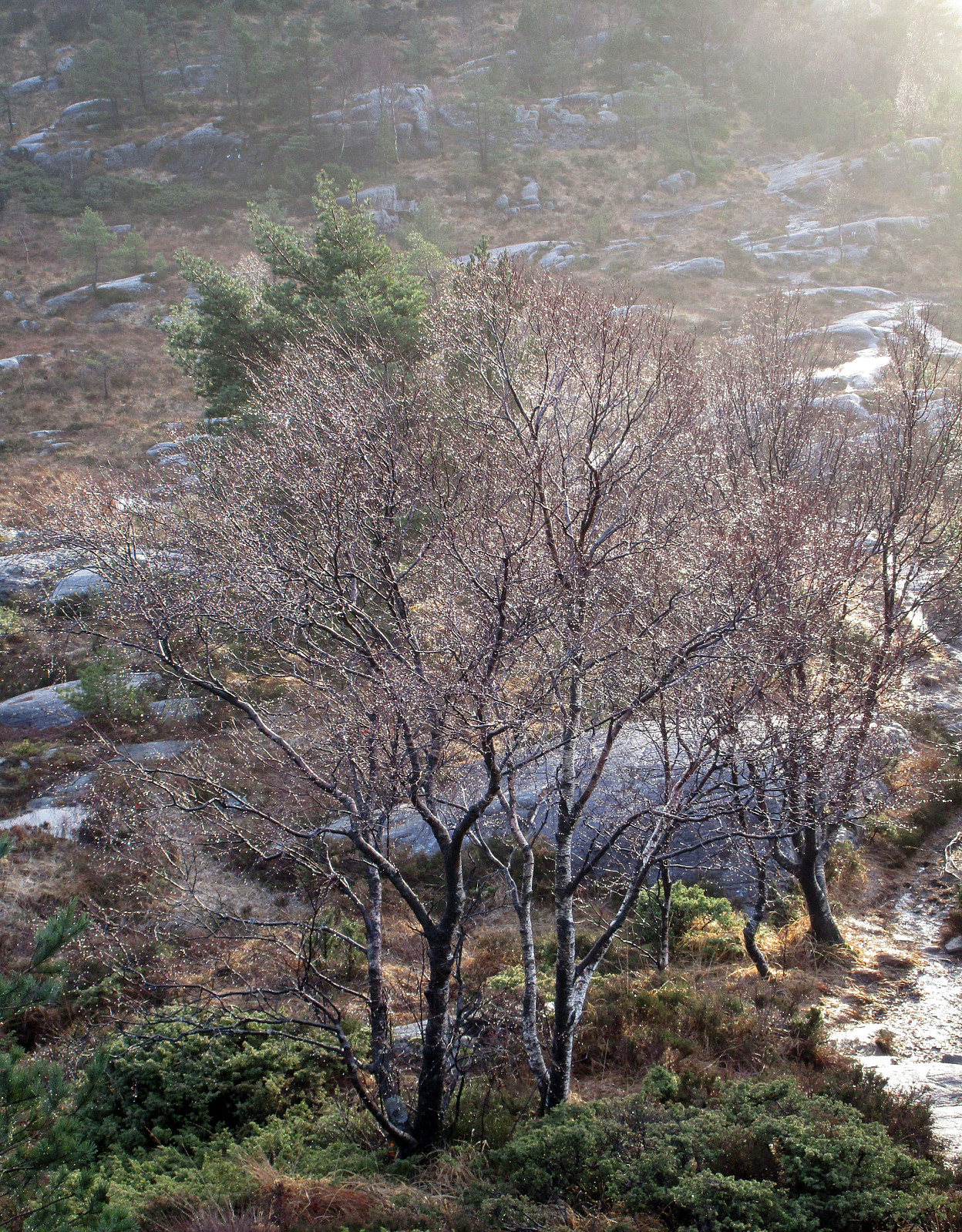
Bjørnaåsen
- Datum:
- 04.12.2016
- Tourcharakter:
- Bergtour
- Tourlänge:
- 0:30h
- Entfernung:
- 1,5km
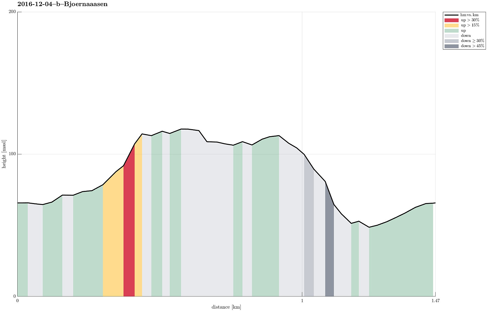 I followed E39 southwards, passing by Os, and heading into the direction of Halhjem, where the ferry leaves towards Vågen on Stord. Right before the ferry port, I turned left (in eastern direction), following Bjørnavegen. I then turned right (in southern direction), continuing on Halhjemsmarka, passing by a little soccer field near Halhjem school. I followed the road until point N60.1402, E5.4393, where I parked. I went a few meters in eastern direction to step out of the houses and into the forrest, which covers all of Sørneset. There, it was basically just following a gradient-search path towards the (small) top of Bjørnaåsen. I crossed over the top until I got at least a limited view towards the south and out onto the sea (through the trees, though), before I returned. I stepped >>>
Skogafjellet
- Datum:
- 04.12.2016
- Tourcharakter:
- Bergtour
- Tourlänge:
- 1:30h
- Entfernung:
- 3,4km
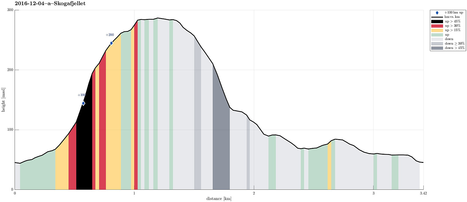 I took E39 southwards from Bergen, driving towards Os. Before coming to Ulven, near Os, I passed by Skogavika (a part of Hetleflotvatnet), lying right next to the road on the eastside. At about N60.2144, E5.4432, I left E39, turning to the right (westwards). Only few meters up this small road, I parked and started walking. I first followed a small, paved road in southern direction (in parallel to E39), which soon turned upwards and westwards (away from E39). Turning left, again, I ended up on a simple gravel road that didn't really seem to lead very far. Instead, I left this road, crossed a few meters of grass and some water, finding an old and overgrown forrest road, leading upwards (steeply) and, first, in southwestern direction (towards Skogafjellet), before soon chaning into a southern >>>
Crossing Høgafjellet from south to north
- Datum:
- 27.11.2016
- Tourcharakter:
- Bergtour
- Tourlänge:
- 2:30h
- Entfernung:
- 5,6km
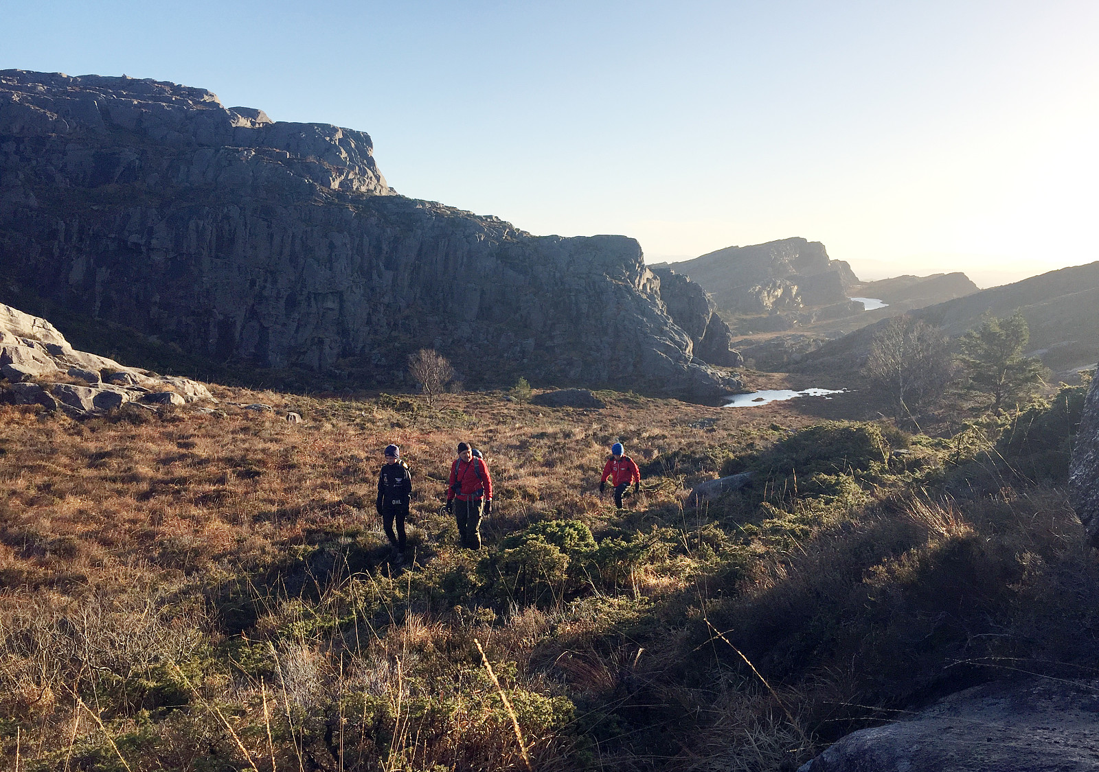 Since we were two families with one car each, this day, we decided to traverse Høgafjellet (from the south to the north), instead of going a round. We took road 555 from Bergen to the west (across the large Sotra-bridge) and then continued further southwards, passing through Fjell. At about N60.312, E5.082, we left one car at the parking place, from which one can access the ruins of previous fortifications (fjellfestningen). Driving further southwards, we connected then to road 204, which leads to Haganes. Instead of driving all the way to Haganes, however, we stopped at about N60.286, E5.103 and started our hike from there. We first crossed over Storhaugmyra (mostly in eastern direction), getting into a small valley, which leads upwards to Kattatjørna. There, we basically changed direction >>>
Ulriken from Montana
- Datum:
- 26.11.2016
- Tourcharakter:
- Bergtour
- Tourlänge:
- 1:15h
- Entfernung:
- 3,4km
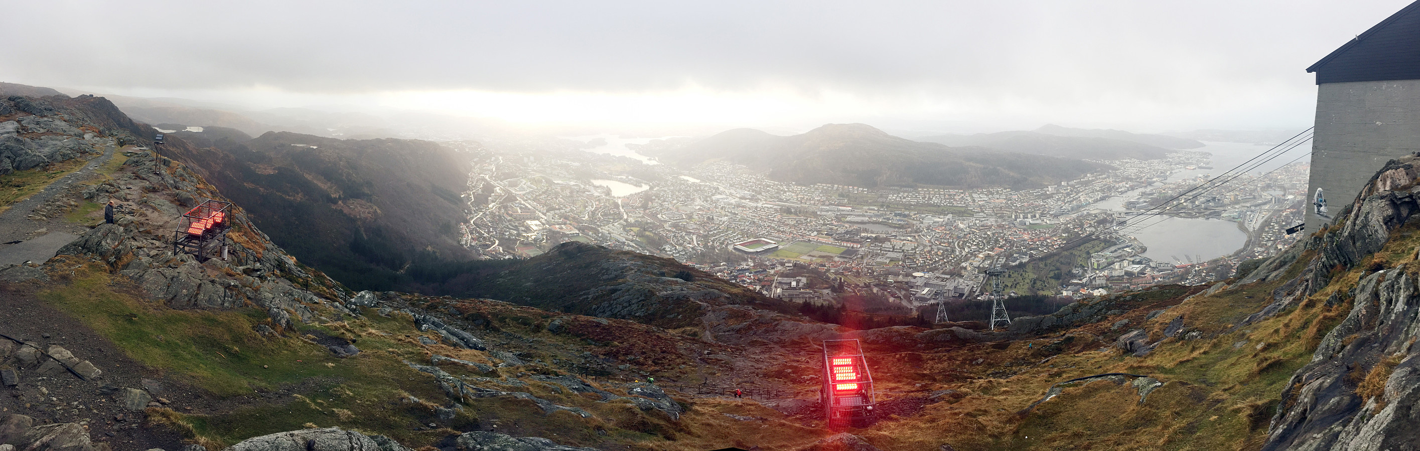 We drove up to Montana and started to hike along Johan Blytts vei, crossing over a little stream and heading further upwards in southeastern direction until we met another forrest road that comes up from the south. We followed then this forrest road for a few steps (mostly in northeastern direction) until the next turn of this road (back into southern direction). At this turn, a whole section of new stone stairs have been built recently, leading upwards in northern direction and towards Ulriken. It was these new stone stairs, which we were eager to see for the first time, of course! :-) We stepped up and reached the top of Ulriken not long after (a little over half an hour, alltogether, from the parking place). Instead of taking the same route down, again, we instead followed the higher >>>
