Archiv - Nach Datum
Archiv - Nach Aktivität
-
Andere Tour (1)
- Kayaking (1)
-
Andere Wintertour (4)
- Schneeschuhtour (4)
-
Fahrradtour (137)
- Fahrradtour Straße (9)
- Fahrradtour gemischt (51)
-
Fußtour (740)
- Bergtour (363)
- Jogging (18)
- Spaziergang (89)
- Wanderung (270)
-
Skitour (4)
- Tourenskilauf (4)
Archiv - Nach Geografie
Peakbookfreunde


Gesammelte Listen
-
Bergen ≥ 50m pf. og ≥ 100 m.o.h.
(87/89)
 97%
97% -
Most dominating tops of the Bergen peninsula
(68/75)
90%
-
Utvalgte topper og turmål i Bergen
(316/350)
90%
-
Alle topper i Bergen
(357/398)
89%
-
Opptur Bergen
(100/113)
88%
-
De syv fjell rundt Bergen
(6/7)
85%
-
Sund ≥ 50m pf.
(14/18)
77%
-
Os ≥ 50m pf.
(25/34)
73%
-
Søyler (fastmerker) i Bergen
(68/100)
68%
-
Fjell ≥ 50m pf.
(21/32)
65%

Hvar cycling, day 2
- Datum:
- 15.07.2005
- Tourcharakter:
- Fahrradtour
- Tourlänge:
- 4:00h
- Entfernung:
- 28,4km
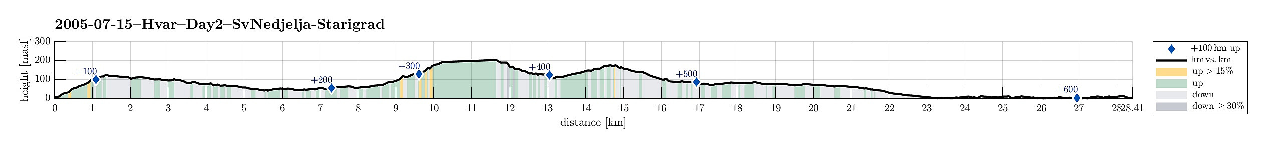 After one (very nice!) day of in and around Sveta Nedjelja, including a visit to the impressive caves, high about the village, we got back onto our bikes. The plan had been made already in Split, when we informed ourselves about cycling on Hvar, and received a map, which very clearly described a round, continuing from Sveta Nedjelja along the southern shore of island Hvar further towards the west, all the way to the settlement of Hvar. After some short investigation, also asking some locals, it quickly became clear that there was absolutely no way to continue cycling into the given direction (there simply was no road at all, not even a gravel road). Thus, we had no other choice than to go back the way which he had taken to Sveta Nedjelja two days ago, including the tunnel! We quickly got >>>
Hvar cycling, day 1
- Datum:
- 13.07.2005
- Tourcharakter:
- Fahrradtour
- Tourlänge:
- 6:00h
- Entfernung:
- 28,9km
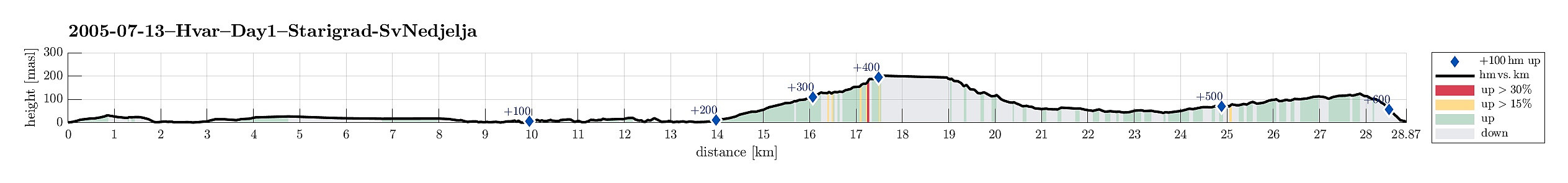 We had taken the ferry from Split to Starigrad on Hvar (just taking our bikes with us) and the first thing we did on Hvar was to actually visit Starigrad, not far from where the ferry stops. Starigrad has a nice harbor and and old town which is clearly worth a visit! In Split, we had informed ourselves about biking opportunities on Hvar and we were motivated by a map that outlined a nice biking path around the island. Accordingly, it was our plan to follow this route and thus we started from Starigrad, heading eastwards. The map told that there should be a nice connection to the east a bit north of the main road. Finding this connection, we had to understand that it was not, as assumed, a paved road, but a "gravel" road with all-too-large rocks all over the path, making it almost >>>
From Schafberg down to St. Wolfgang
- Datum:
- 06.07.2005
- Tourcharakter:
- Wanderung
- Tourlänge:
- 6:00h
- Entfernung:
- 10,5km
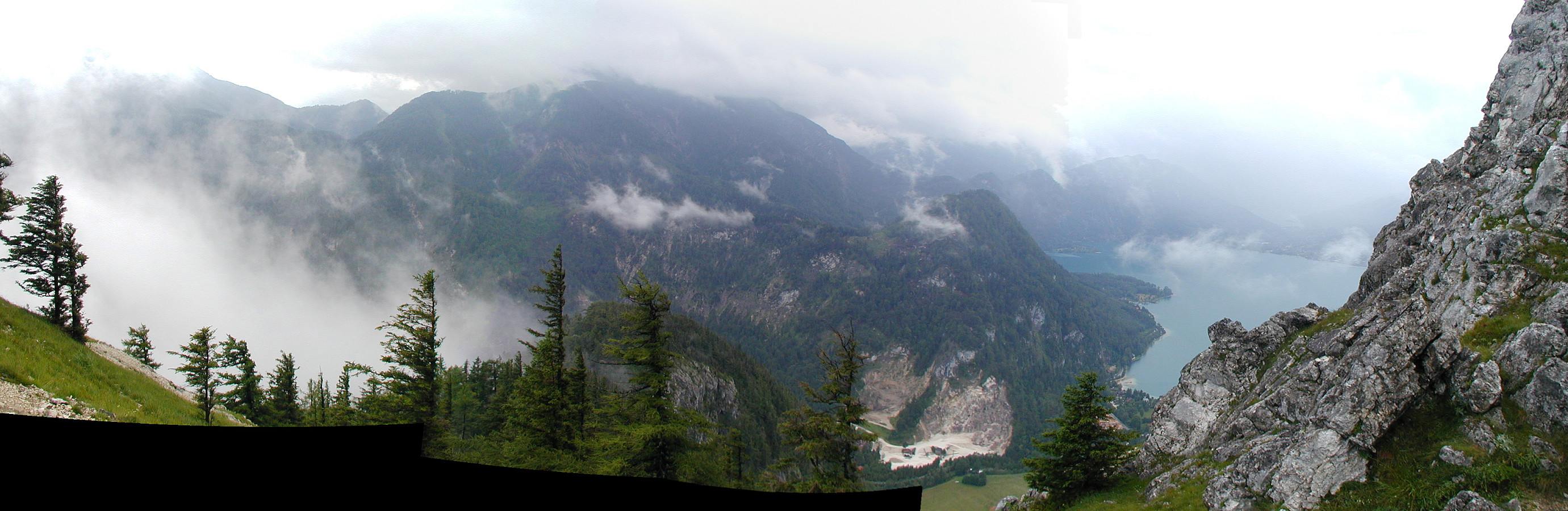
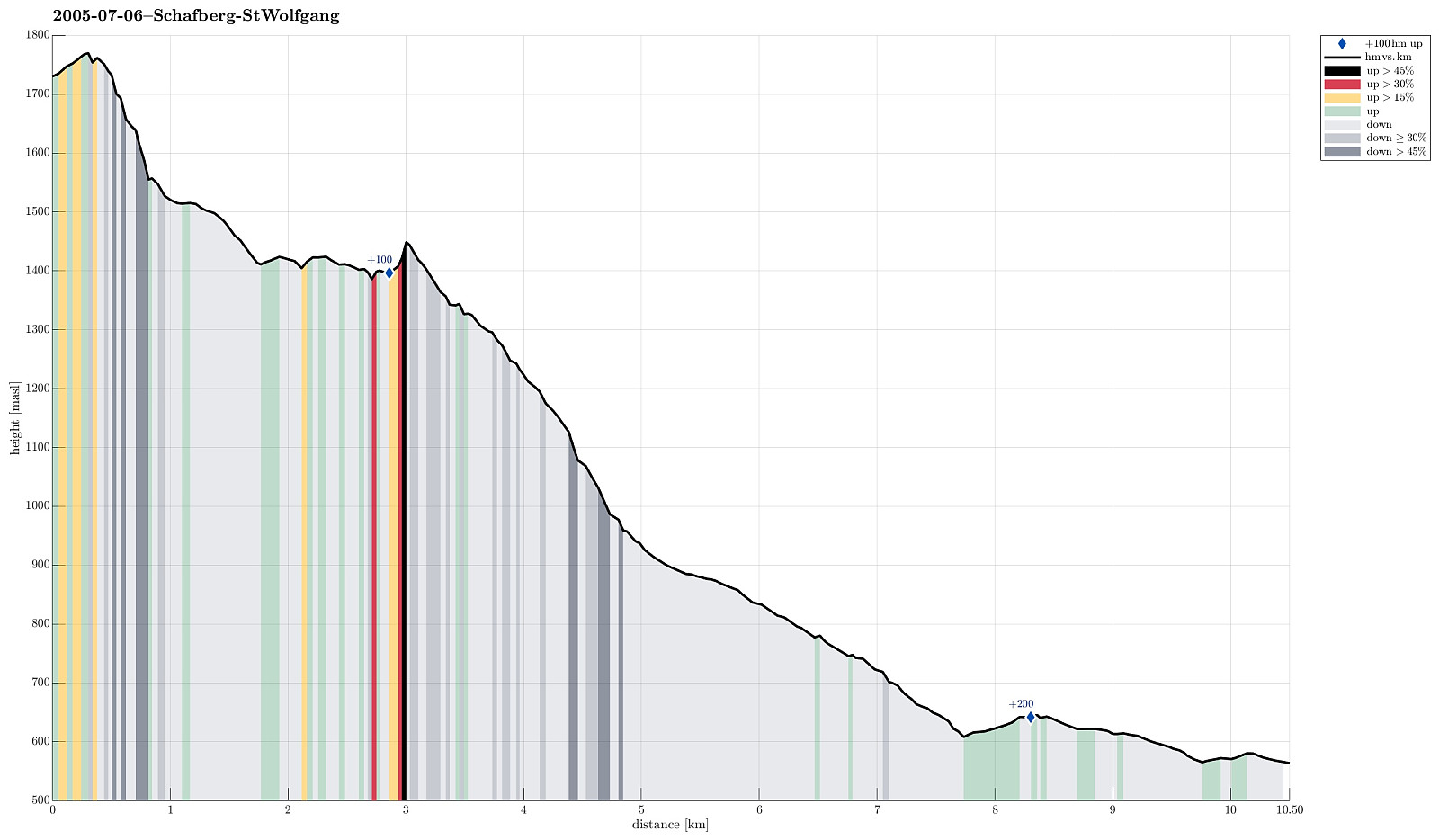 We first took the mountain rail up to the top of Schafberg with the plan to walk down from there to St. Wolfgang. From the top, we then descended first towards the nearby Himmelspforte (in northwestern direction). There, we then started the real descent, which indeed is quite steep on the northern side of Schafberg, at least in the beginning. We followed the Himmelspfortenweg downwards, passing by Suissensee, and rounding another ridge to get to Mittersee, a nice little lake underneath the majestic Schafberg. From there, we continued further along this path, getting very close to Mönichsee, before we eventually got (back) to the southwestern side of Schafberg, heading down towards St. Wolfgang. We quickly arrived at the Auerriesenweg, which we then followed down until we basically were >>>
From Weissenbach to the Haleswiessee and back
- Datum:
- 04.07.2005
- Tourcharakter:
- Wanderung
- Tourlänge:
- 4:00h
- Entfernung:
- 6,2km
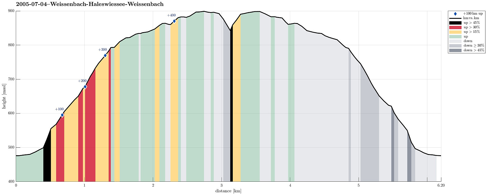 We started from the Waldsiedlung in Weissenbach am Attersee and ascended on the southern side of the valley until we came to an intermediate height, almost meeting Loidlbach, which nearby takes a turn to the left and towards the Burgaubach further down (west of Weissenbach). Instead of continuing further up to one of the nearby mountains, we instead crossed a saddle to get further towards Haleswiessee, a nice little lake, surrounded by the mountains around it. We enjoyed some time up there, before we returned, basically along the same path that we had taken up first.
See also the related FB-page Hiking around Bergen, Norway .
We started from the Waldsiedlung in Weissenbach am Attersee and ascended on the southern side of the valley until we came to an intermediate height, almost meeting Loidlbach, which nearby takes a turn to the left and towards the Burgaubach further down (west of Weissenbach). Instead of continuing further up to one of the nearby mountains, we instead crossed a saddle to get further towards Haleswiessee, a nice little lake, surrounded by the mountains around it. We enjoyed some time up there, before we returned, basically along the same path that we had taken up first.
See also the related FB-page Hiking around Bergen, Norway .
Kleiner Schoberstein from Weissenbach
- Datum:
- 02.07.2005
- Tourcharakter:
- Bergtour
- Tourlänge:
- 3:00h
- Entfernung:
- 4,4km
 We started from Weissenbach am Attersee and ascended via the western ridge of the Höllengebirge up to Schober (Kleiner Schoberstein). Clearly, this is a nice (and not so long) hill-walk for those, who are enjoying some good time at lake Attersee!
See also the related FB-page Hiking around Bergen, Norway .
We started from Weissenbach am Attersee and ascended via the western ridge of the Höllengebirge up to Schober (Kleiner Schoberstein). Clearly, this is a nice (and not so long) hill-walk for those, who are enjoying some good time at lake Attersee!
See also the related FB-page Hiking around Bergen, Norway .
