Almelandsfjellet etc. (10.08.2025)

| Startpunkt | Osvegen (60m) |
|---|---|
| Endpunkt | Osvegen (60m) |
| Tourcharakter | Bergtour |
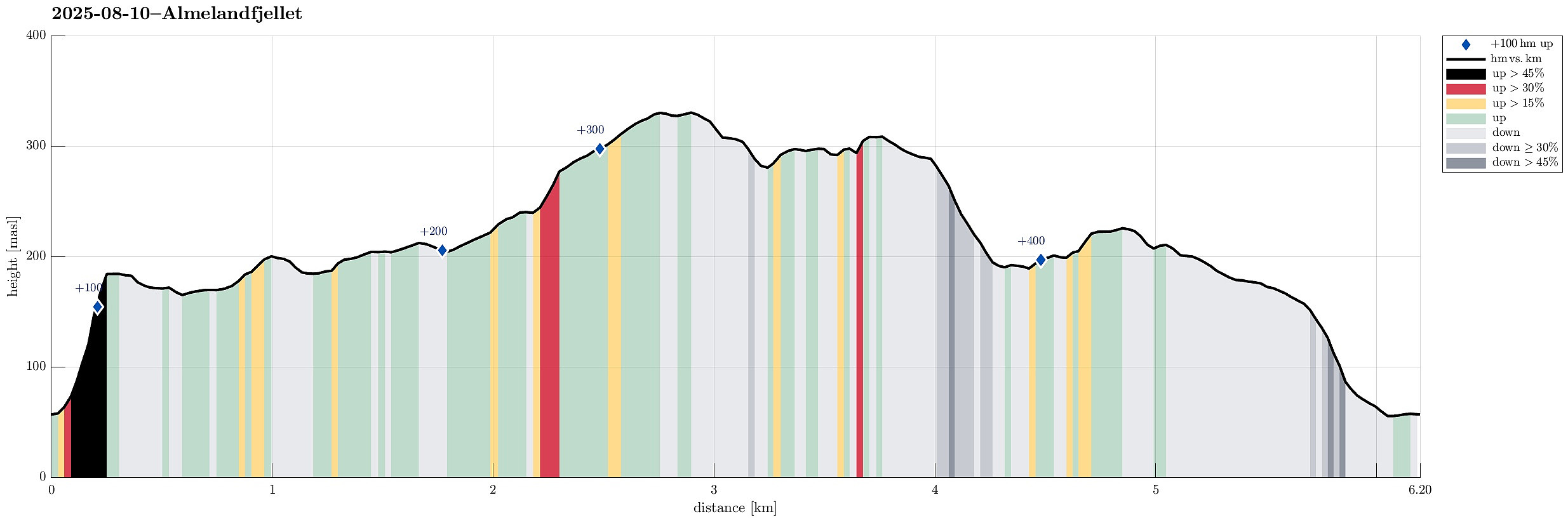
| Tourlänge | 3h 00min |
| Entfernung | 6,2km |
| Höhenmeter | 447m |
| GPS |
|
| Besteigungen | Blåurskampen (187m) | 10.08.2025 |
|---|---|---|
| Hattråsen (312m) | 10.08.2025 | |
| Kampen (230m) | 10.08.2025 | |
| Smørkisfjellet (334m) | 10.08.2025 | |
| Besuche anderer PBE | Almelandsfjellet (290m) | 10.08.2025 |
Avoid the shown route up to Blåurskampen: too steep, too wild, not safe!
Trip Summary
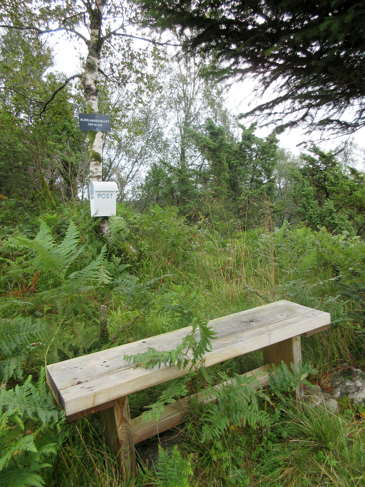
On this partially wet Sunday, the plan was to make something not too long and not too far away. Since I had not visited Smørkisfjellet before, I "cooked up" a round, starting from Osvegen near Kalandseidet. I somehow thought that I could try an ascent to Blåurskampen from the west (even though I had seen during my map study at home that this side of this hill is very steep with quite some cliffs, actually). I started from right underneath Blåurskampen and already down at Osvegen I wondered whether this really was such a good idea (it was not). I still entered the terrain and quickly found out: (a) it was wet from all the rain, (b) there was a lot of vegetation, and (c) it is truly steep -- at times way too steep there. I still continued (why?), making height meters relatively quickly. Soon, however, I ended up underneath vertical cliffs, requiring some side-stepping (in northern direction). Eventually, it became climbing in way too steep terrain (and given that everything was wet, this really was not smart). Luckily, I still made it across the steepest part, emerging at the (on the top actually quite gentle) heights of Blåurskampen. I then traversed Blåurskampen in southern direction, crossing a number of small drainage canals before connecting with a gravel road that's leading further northwards from the east of Blåurskampen. I did not, however, follow this gravel road for long, but instead chose a continuation across Styrshaugen and towards the small stream that runs down in the south of Grøndalen. While stepping northwards on the westside of this stream, I then connected to a marked trail, which I then followed towards the northeast of Grøndalen. From there, this trail lead me further upwards (in northeastern direction) until I came to the ascent across Stongelia. Since all this was well on the nicely marked trail, progress was fast and easy. As soon as I came close to Smørkisfjellet, I then left the trail to explore the top of it. After a round over the top heights of Smørkisfjellet, I then started my traverse over to Hattråsen in the west of Smørkisfjellet. I first descended from Smørkisfjellet in eastern direction until I ended up in a small valley north of Kjerringaskaret. There, I connected with a marked trail, again, which brought me down to the gravel road that extends further into Hattråsdalen. Since I wished to visit Hattråsen, also, I did not follow this road for any longer stretch, but instead searched my way in western direction (first). Interestingly, I somehow managed to include a circle on one of the hills in the west of the gravel road, before stabilizing my direction, again, and getting up to Hattråsen. Near the "top" of Hattråsen, I actually started to see some plastic markers (not really any trail, though). From Hattråsen, I then continued along the ridge in southwestern direction (above Hattråsdalen, quite a bit further down towards the southeast). After a while, I again saw some plastic markers, hanging from some trees. Following them further down the ridge resulted in the biggest surprise of the day: Almelandsfjellet! At about 290 masl, I suddenly found myself at a place with a bench, a sign "Almelandsfjellet, 290masl", and a "post box", which contained a little booklet (first entry 2021, if I remember correctly). The place is in fact nice, offering a good view down to Almeland in the west. Since I anyway had planned to explore the southern ridge from there, I considered myself quite lucky to still find plastic markers, even south of Almelandsfjellet. It did not take me long to descend this rather steep ridge (and the markers reassured my confidence). My next goal was then Kampen, further "down and across" in southwestern direction. After crossing a road, I made it quickly up the next ridge (and up to Kampen). This "top" is not really anything special, just by itself, but Edne, a bit further south, then turns out to be quite nice. Once I had made it to Edne, I then continued further in southwestern direction, following the ridge. Once down to about 175 masl, this ridge opens up, turning into a rather broad meadow. I knew that there was no way down in western direction (too steep, cliffs), but I thought that chances were OK to find a descent route in southern direction. And yes, while steep, this turned out to be true: in fact, I even got the impression of something like a weak trail down there. Within not too long, I made it back down successfully. All in all, it's fair to report that this route is not "all good" and especially the initial ascent to Blåurskampen is not something that is recommended in the presented form -- instead, one should appraoch this "top" from the south or northeast, maybe (or not at all). Finding Almelandsfjellet, however, was an amusing surprise! :-)
Photos
Selected photos are available as Google photo album.
Useful Resources
See also the related FB-page Hiking around Bergen, Norway.

Benutzerkommentare
Almelandsfjellet
Geschrieben von river 12.08.2025 16:14I'm glad to hear you enjoyed Almelandsfjellet. I cut down many trees there and put up a bench, sign, and mailbox a few years ago! Since I no longer live in Almeland, I don't hike there as often as I used to, so it may have become a bit overgrown.
https://paturnorge.no/turtips/premium/almelandsfjellet-290-gimmeland
Re: Almelandsfjellet
Geschrieben von HHauser 12.08.2025 18:06Many thanks for writing! Indeed, Almelandsfjellet was an unexpected surprise! And clearly, I could see the massive effort that someone (you!) put into marking the route there, clearing the spot, etc. The little booklet had a couple of pages with entries (many with surname Almeland, in fact! :-)), but it wasn't clear whether this wasn't mostly a few years back, altogether. The bench is still in good shape, though! :-)