Melderskin from Grønestølen (via Store Laurdalen) (17.05.2025)

| Startpunkt | Grønestølen (165m) |
|---|---|
| Endpunkt | Grønestølen (165m) |
| Tourcharakter | Wanderung |
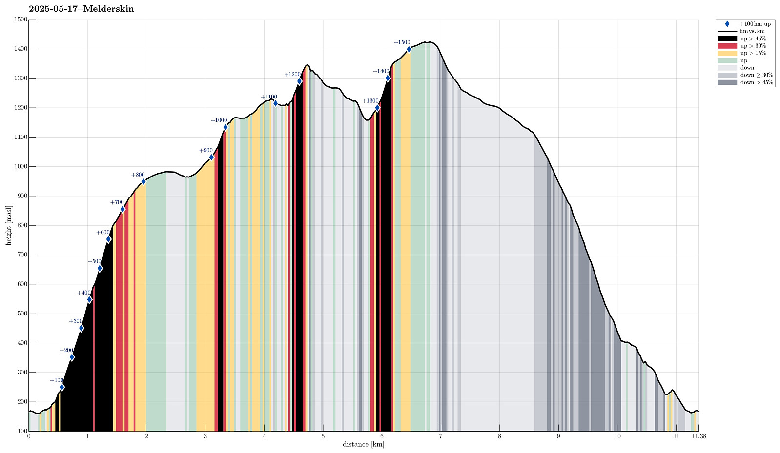
| Tourlänge | 12h 00min |
| Entfernung | 11,4km |
| Höhenmeter | 1.581m |
| GPS |
|
| Besteigungen | Melderskin (1.425m) | 17.05.2025 |
|---|---|---|
| Omnetinden (1.378m) | 17.05.2025 | |
| Besuche anderer PBE | Skardshaugen (880m) | 17.05.2025 |
Trip Summary
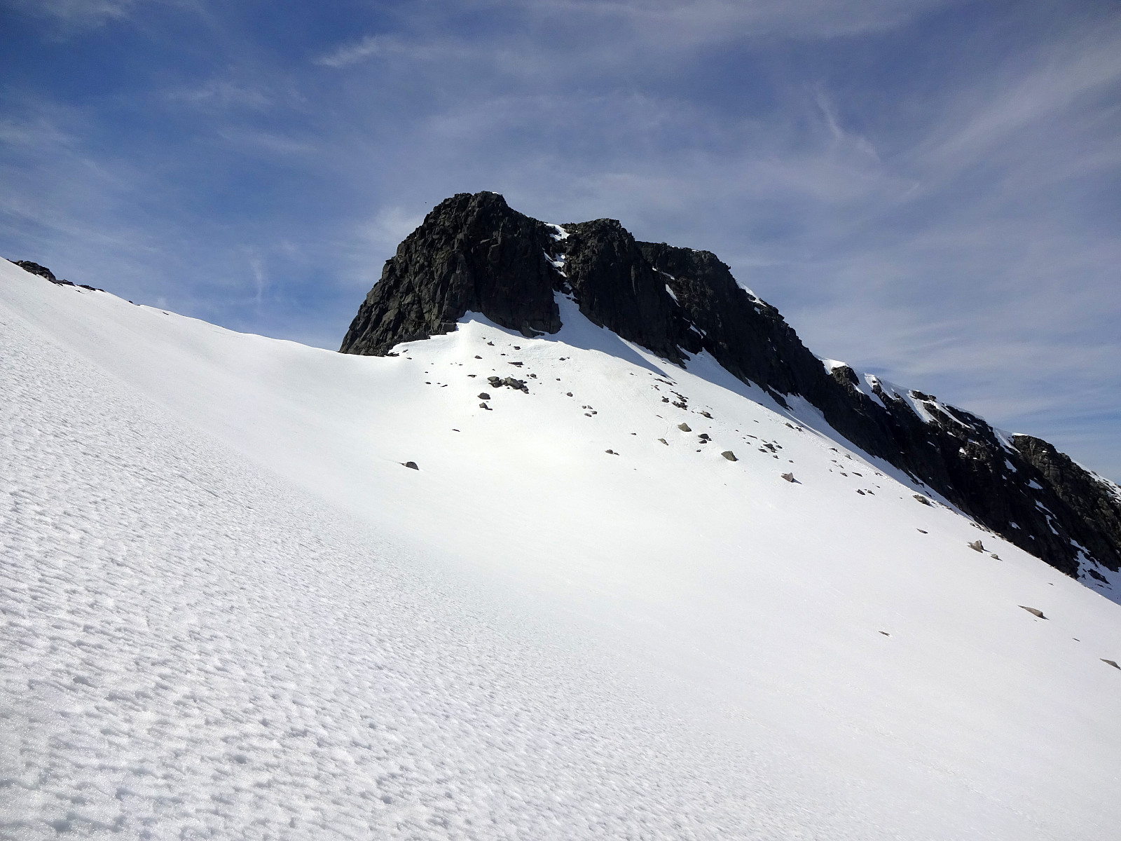
For quite a while we had talked about hiking Melderskin one day. Would we have guessed that our window of opportunity to do so would open up exactly on May 17? With an excellent weather forecast in our hands, we decided on rather short notice that we would leave Bergen after work on May 16, taking the fast ferry to Rosendal. We then stayed at Grønestølen over night -- what a nice place?! From there, we then started our hike to Melderskin in the morning of May 17. Our plan was (first) to try getting up to Store Laurdalen in the northwest of Laurdalselva (without a trail). We had studied the map in quite some detail to support our assessment that this should be possible (even though the terrain is certainly very steep there in places). From there, we had (first) in mind to continue the ascent "diagonally" in northwestern direction to get up to a height (about 1100masl) in the east of Skardshaugen. From there, we had (first) intended to continue further upwards, along the southeast facing cliff, to eventually reach Melderskin. The first small challenge was to find a good connection to the actual "entry spot" to the steep "ramp" between Tryglabekken in the northwest and Laurdalselva in the southeast. Fortunately, it did not take us too long to find our way through the forest. The first roughly 300 height meters were then really nice (but definitely very steep) and we found a very doable route that did not require the use of our hands often. Once above 500masl, or so, we needed to "get around" a cliff-like part between Tryglabekken and Laurdalselva (this had been clear already from our map study). Partially, the terrain got still even steeper, and we had to use our hands a bit more often to make 300 additional height meters. At about 800masl, we started to "enter" Store Laurdalen, enjoying (a) the sun, just risen above Laurdalstinden in the east, and (b) the lovely landscape of Store Laurdalen, "flattening out" above 800masl towards the northeast. It was then roughly at this point, where we discussed the idea of changing our plans and "hiking Melderskin from the backside", instead. We had seen a couple of other hiking tracks, which documented how others had hiked around Omnetinden, for example, and up to Melderskin from the north, which gave us confidence that this alternative ascent route should be possible. Also, we had been curious to see the small lake at the upper end of Store Laurdalen. After a short consideration of our options, we decided to give the alternative route a chance and continued further up and into Store Laurdalen. Soon, we got to see the little lake right in the north of Laurdalstinden. Getting there, however, turned out to be more tricky than originally thought: an entire field of large bolders and rock forms the "outer rim" of the lake and getting close anywhere means to find one's way trough (and above) this maze of bolders and rocks. We still made it and enjoyed a nice, short break at the lake (about 960masl). After again crossing the bolder maze after the break, we next aimed at the saddle between Omnetinden in the north and Inste Laursdalstinden in the south. From down in Store Laurdalen, we had identified two variants to get there: either up the southern slopes of Melderskin, first, and then over to the saddle, or first further into Store Laurdalen, and then up to the saddle. Not sure about any of the two, we decided to try the former. Getting up to about 1150masl was then nice and easy (steep, yes, but nicely on grass, mostly), while getting across to the saddle was a bit less nice, crossing rather steep terrain with some lose rocks, followed by a snow field. Making it up to the saddle at about 1220masl, however, was still no really big challenge. Once on the saddle, we first enjoyed the new views (towards the east, including some nice views into the direction of Bjørndalstindane). Next, it became clear that our next challenge would be to cross a steep snow field in northwards direction to "get around" Omnetinden in its east. After first checking the snow condition a bit, we then found it well doable -- especially with the help of our hiking poles. Still, very careful stepping was 100% required to avoid any stupid fall down towards the east (with highly likely dramatic consequences). Once "on the other side" (on the northeastern ridge of Omnetinden), we then turned around (and towards Melderkin). Stepping up this northeastern ridge of Omnetinden was actually straight forward and nice (yes, steep). Once past Omnetinden, while approaching Melderskin from the east, we carefully studied the eastern cliff side of Melderskin from below, checking for a possibility to ascend Melderskin "directly". Given the amount of snow, some of which had clearly started to tumble down, already, we rather quickly decided that also Melderskin required a "walk-around" on this day. We thus cut across the snow fields in the east of Melderskin (mostly in northwards direction) to connect with the northern ridge of Melderskin (up from Omnen). Given the somewhat less optimal snow condition on this stretch, we actually found it releaving to quickly complete this traverse without any difficulties. Once on the ridge up from Omnen, we first ascended via a snow field (very steep, but OK to step up on it), before then continuing over a rocky stretch of this ridge (to get up there, we clearly needed to use our hands basically all the time and finding an OK enough route to get further upwards was not always 100% clear in all places). When approaching roughly 1350masl, however, the terrain flattened out very nicely and completing our ascent to Melderskin then was nice and enjoyable! :-) After a short break on the top, also enjoying outstanding views in all directions, we then started our descend, following the main trail, including also the impressive stone steps during the ascent from Skardshaugen. The final "challenge" of the day was then to bridge back to Grønestølen without a trail, again. Our map study had suggested that we could follow the main trail down to about 400masl, before then heading southwards to get back to Grønestølen. This did indeed work, after all, but it included a few sections, where vegetation challenge our progress. Eventually, we returned to Grønestølen after about 12 hours, clearly satisfied with the hike (and with being back and relaxing our legs a little)! :-)
Photos
Selected photos are available as Google photo album.
Useful Resources
See also the related FB-page Hiking around Bergen, Norway.
Petter Bjørstad has a useful page about Melderskin and also web page WestCoastPeaks.com provides useful information about Melderskin, Omntinden, Laurdalstind, and Inste Laurdalstind.
Web page UT.no from the Norwegian Trekking Association recommends the standard hike up and down Melderskin.

User comments