Herlandsfjellet from Herland (09.11.2024)

| Startpunkt | Herland (45m) |
|---|---|
| Endpunkt | Herland (45m) |
| Tourcharakter | Wanderung |
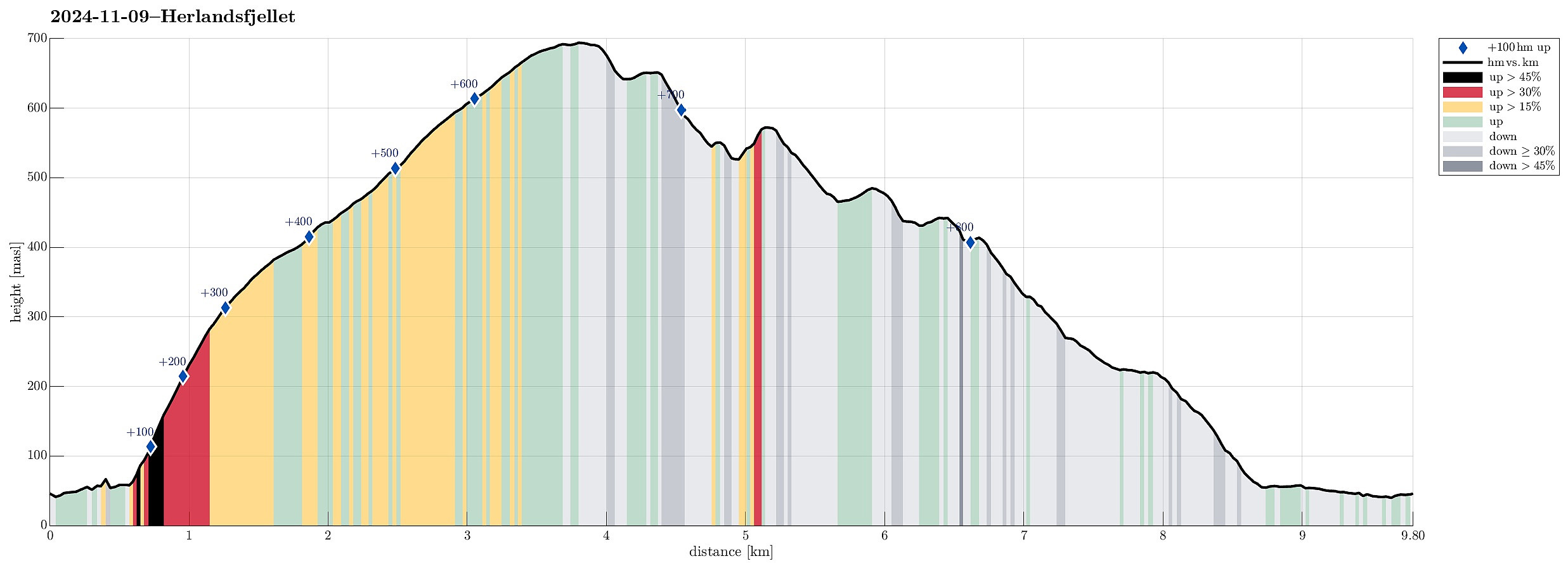
| Tourlänge | 4h 30min |
| Entfernung | 9,8km |
| Höhenmeter | 838m |
| GPS |
|
| Besteigungen | Herlandsfjellet (695m) | 09.11.2024 |
|---|---|---|
| Nordnuken (574m) | 09.11.2024 | |
| Onuken (485m) | 09.11.2024 |
Trip Summary
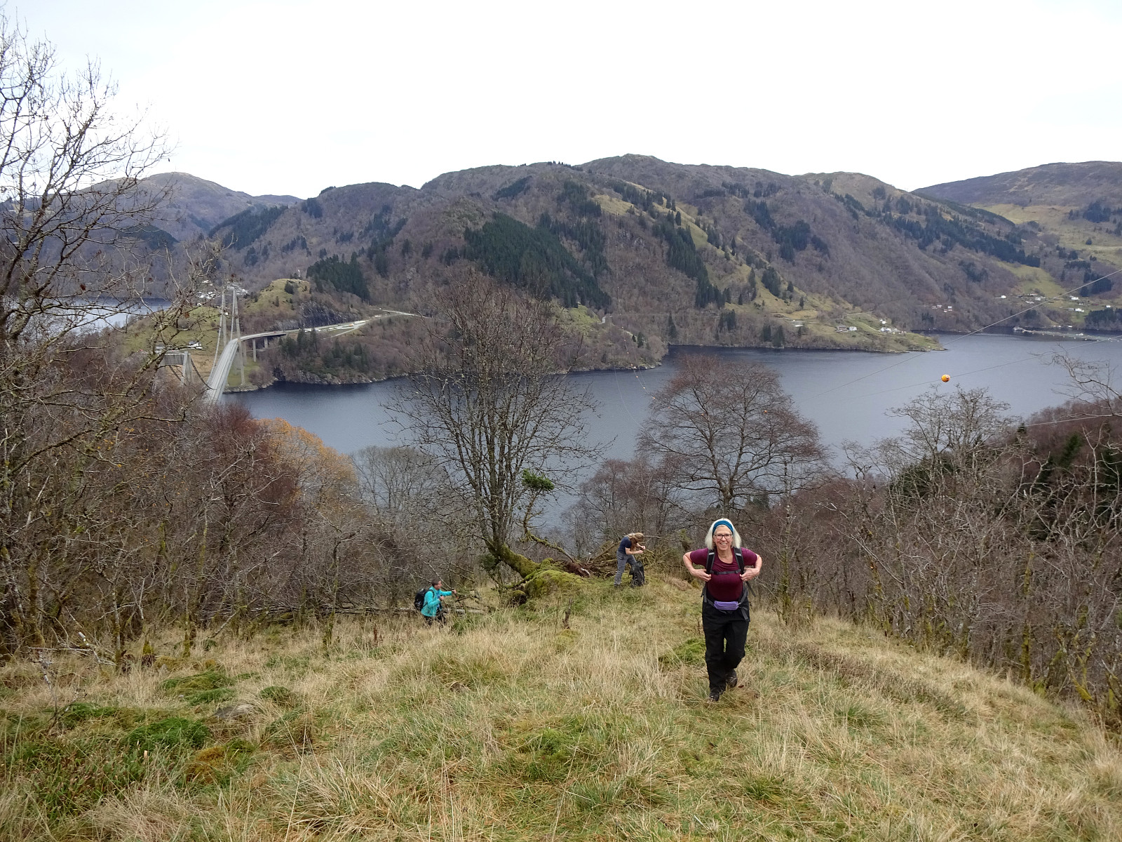
We had this one day and wished to do a nice hike with approximately 800 height meters. We took inspiration from an earlier approach to Herlandsfjellet and aimed at repeating the same ascent from Herland. Again, we parked near the bridge to Osterøy. We then "went around" to get to the southern side of E16, following Romslovegen for a short stretch (and over E16). On the other side, we followed a short side road that would bring us to the actual starting point of the ascent right next to Kjerringaelva. As last time, we followed the ridge between Holebekken in the west and Kjerringaelva in the east to find our way up to Saurinden. This is a steep ascent, but the terrain is easy to traverse. Once above 150masl, it's no longer "very steep", and then above 300masl it's basically a gentle slope upwards. The next 200 height meters are then through a very nice, half-open forest, before one steps out of the forest at about 500masl. From there, one can then enjoy the first panoramic view towards the north (with Sørfjorden, Osterøy, and more). Following Saurinden further upwards brings one then to Herlandfjellet without any difficulties. At Herlandsfjellet, we compared our options of how to get back (through Songstaddalen). Eventually, we agreed on trying a creative option that would connect Nordnuken and Tunga "in the middle of Songstaddalen", instead of following the trail that extends north-south on the eastern side of Songstaddalen, passing over the somewhat wet Sethaugane). Thus, our first goal was to descend from Herlandsfjellet via its eastern (relatively steep) side and to get over to Nordnuken. In our previous hike, we also connected Herlandsfjellet and Nordnuken, but did so a bit further south. Traversing Høystakkliane was a bit steep, back then, and so we tried a slightly more northern route this time. This included the nice option to visit the slightly lower ridge right in the east of Herlandsfjellet, which further north extends to Ytre Songstad, becoming a prominent ridge further down there. Even though this descent also was steep, we still did not find it very difficult to get down to Nordnukskaret and then up to Nordnuken on the other side. Since Nordnuken gets quite a bit steep on its northern side (with some cliffs, also), we decided to first get down from Nordnuken in northwestern direction (almost towards Nordnukskaret, again), before heading further north and into Songstaddalen (into the direction of Litle Songstaddalen). With some careful stepping, we all made it well down so that we could target the next intermediate goal: Onuken. Getting there was not difficult, but stepping up to Onuken included a very short "bush war" through some einerkratt (juniper). Descending from Onuken on its northern side required a bit of a "walk-around" to void a cliff at the northern end of Onuken. We then continued further northwards, towards Songstadsetra and Tunga. North of Songstadsetra, we then connected with the trail through Songstaddalen, which we then followed out to Nystølen and then down to Romslovegen at Indre Songstad. From there, we just walked a short stretch along Romslovegen back to the car. Altogether, a very nice hike! :-)
Photos
Selected photos are available as Google photo album.
Useful Resources
See also the related FB-page Hiking around Bergen, Norway.
Web page WestCoastPeaks.com provides useful information about Skåldalsfjellet, Herlandsfjellet, Repparåsen, and Arnanipa.
Web page UT.no from the Norwegian Trekking Association recommends a "more standard" hike to Herlandsfjellet (from Osavatnet).

Benutzerkommentare