Burlifjellet and Skorafjellet (19.05.2024)

| Startpunkt | Kjøpmannavadet (250m) |
|---|---|
| Endpunkt | Kjøpmannavadet (250m) |
| Tourcharakter | Wanderung |
| Tourlänge | 5h 00min |
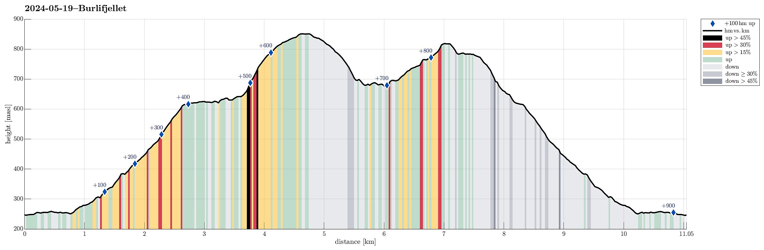
| Entfernung | 11,1km |
| Höhenmeter | 899m |
| GPS |
|
| Besteigungen | Burlifjellet (854m) | 19.05.2024 |
|---|---|---|
| Skorafjellet (821m) | 19.05.2024 | |
| Besuche anderer PBE | Kjøpmannavadet Parkering (250m) | 19.05.2024 |
Trip Summary
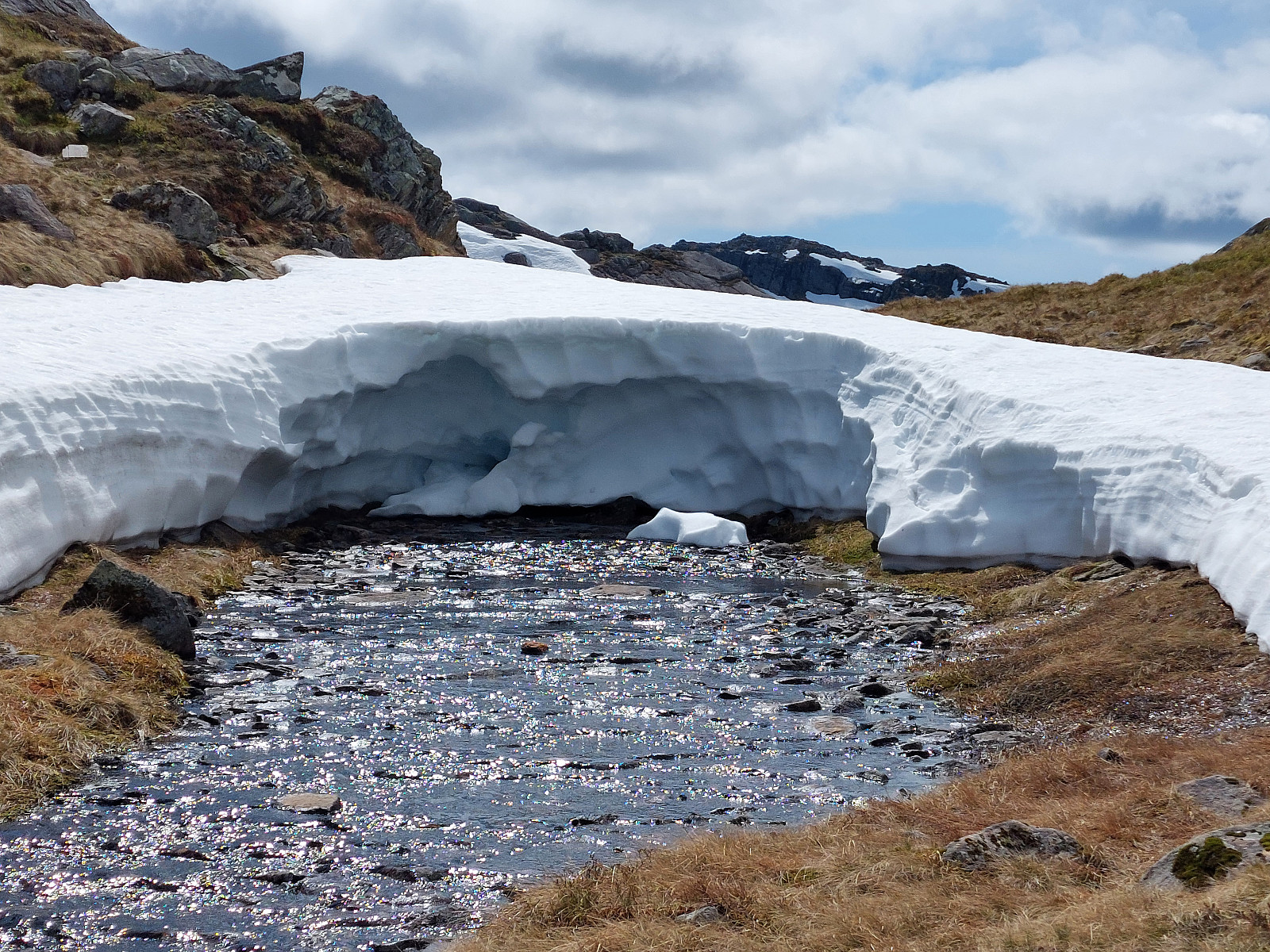
Driving north from Fusa, into the direction of Samnanger, we passed through Eikelandsosen, first, continuing further northwards along road 48. At Sævell, right after passing by Sævellavatnet, we turned right onto Sævellvegen. Near Høgehaugen, we paid a bit of road-toll in order to continue along Sævellvegen. Driving carefully (Sævellvegen is not paved further inwards), we arrived at Kjøpmannavadet shortly after. There, right next to the bridge, we parked at the side of the road. Crossing over the bridge southwards, we started our hike along a forest road that leads to Breivatnet just a little down the road. There, one crosses over Breielva right next to a small cabin right at Breivatnet. A marked trail then leads up to Helane and from there further towards the lower end of Lisetredalen. Following the trail, it's easy to find the "entry" into Lisetredalen; walking this valley then upwards is quite nice (Lisetredalen extends kind of "diagonally" below Røyrlia; still, it is relatively narrow and kind of cut into the mountain side). At about 380 masl, one steps out of Lisetredalen at its upper end; there, the trail turns right and up into the direction of Lisetreåsen. At about 620 masl, the trail then turns left, leading around some steeper sections. Walking "around" up there, one does not make much additional elevation, while enjoying some really nice views towards the west. Next, one approaches Markskilatjørna "around the corner" with some almost dramatic views! :-) The trail then passes by Markskilatjørna in its north, leading into the valley that comes down from Svartatjørni a bit further up. Crossing over the stream there, one gets into another valley that also leads up to Svartatjørni (but a bit further north). Continuing further upwards through this valley (now mostly in eastern direction) is nice an easy and soon one comes to the point, where the ascent to Burlifjellet "forks off" to the left (northwards). Hiking up to Burlifjellet is then just to follow this marked trail. Eventually, Burlifjellet welcomes the hiker with a nice cairn and some nice views in all directions! :-) After enjoying some lunch on Burlifjellet, we continued our hike (with the goal to also include Skorafjellet a bit further south). We descended from Burlifjellet southwards along the same marked trail that we had first taken up. Instead of heading all the way down to Markskilatjørna, however, we crossed over to Svartatjørni, passing by this rather large lake in its west. There, we did not really find any trail, but making progress towards Skorafjellet was easy and "straight-forward" anyway. We used a valley in the southwest of Svartatjørni to get closer (and up) to Skorafjellet. This valley leads up to another lake at about 740 masl. There, we started our final ascent to Skorafjellet. While Skorafjellet is partly steep on its southeastern side, we still found our way up without any difficulties. On Skorafjellet, we enjoyed some more nice views before starting our descent. The idea was now to descend along the northern ridge of Skorafjellet (into the direction of Markskilatjørna). To get down from the top of Skorafjellet on its northwestern side, we had to find a spot where it was not too steep. While this worked very well, it seems recommended to do this in the southwest of Skorafjellet (and not along "the direct route" towards the northwest). Once on the other, northern side of the small "cut" in the northwest of Skorafjellet the continuation further northwards and down Skorafjellet's northern ridge was then easy-going and without problems. Still, also there at times one comes close to some cliffs and walking aroud them helps to avoid unnecessary difficulties. Instead of descending "all the way" to Markskilatjørna, we found a convenient spot to "turn left" and to "short-cut" down to the ledge, where we had done our "walk around" before first approaching Markskilatjørna while coming up en route to Burlifjellet. Once back on the marked trail, it then was "just" to descend back down along the same trail that we had taken up, earlier. All in all, this hike up to Burlifjellet and Skorafjellet was really very nice.
Photos
Selected photos are available as Google photo album.
Useful Resources
See also the related FB-page Hiking around Bergen, Norway.
Petter Bjørstad has a useful page about Burlifjellet and also web page WestCoastPeaks.com provides useful information about Tindafjellet, Trælafjellet, Solafjellet, and Burlifjellet.
Web page UT.no from the Norwegian Trekking Association recommends a similar hike up to Burlifjellet.

Benutzerkommentare