Nordra Såta, Tyssdalsfjellet, and Borgafjellet (26.03.2023)

| Startpunkt | Tyssdalen (45m) |
|---|---|
| Endpunkt | Tyssdalen (45m) |
| Tourcharakter | Wanderung |
| Tourlänge | 4h 00min |
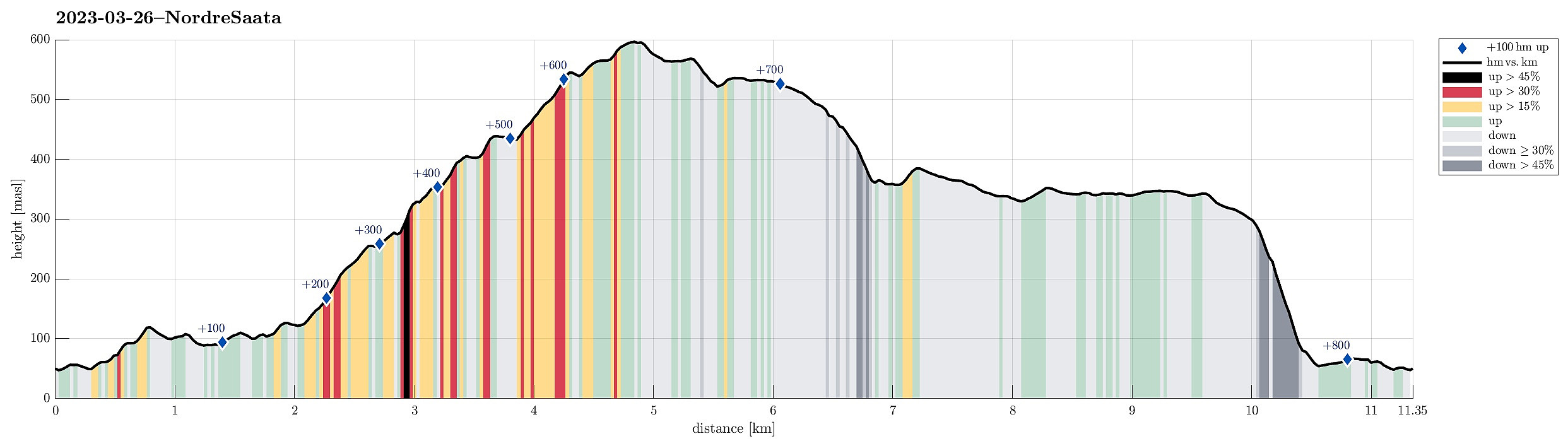
| Entfernung | 11,4km |
| Höhenmeter | 818m |
| GPS |
|
| Besteigungen | Borgafjellet (353m) | 26.03.2023 |
|---|---|---|
| Søre Såta (578m) | 26.03.2023 | |
| Tyssdalsfjellet (605m) | 26.03.2023 | |
| Besuche anderer PBE | Borgly (354m) | 26.03.2023 |
| Borgabuo (349m) | 26.03.2023 | |
| Nordra Såta (415m) | 26.03.2023 | |
| Tøsdalen parkering (60m) | 26.03.2023 |
Trip Summary
For a longer time, we had considered to visit Nordra Såta in the west of Tyssdalsfjellet (and Møsnuken). To do that, we drove to the parking spot at the lower end of Tyssdalen east of Tyssdalsvatnet (northeast of Ulven). Instead of following the main trail (up through Tyssdalen), we headed north (or even northwest) after crossing Tyssdalselva. We first followed the road (Tøsdalsvegen) for a short stretch until we crossed another minor stream there. There, in the south of Lyhaugen, we left the road and ascended first to a small hill south of Lyhaugen (with a post of a power line up there). It was a bit steep to get up there and one may wonder what it's worth this effort (or any, actually). :-) We then continued to Lyhaugen (also a bit steep, but also without actual problems). From Lyhaugen, we then headed towards the forest road that extends northwards from Tøsdalen, somewhat in parallel to Hetleflotvatnet and mostly on about the same height of about 100masl. After then following this forest road for about one kilometer towards the north, we came close to the point, where we thought to enter Almedalen in northeastern direction. To get into Almedalen, one could simply continue along the forest road (a bit "down and around"). Instead, we deviated from the road at the saddle point and found a very reasonable "direct" connection to Almedalen (in northeastern direction). Some 250 meters further up, we entered Almedalen, also finding a (newly marked?) trail up through Almedalen. The trail through Almedalen is not really visible as a trail, but every now and then, one can find some (new?) markers (sticks with some red color on top) and finding the way up through Almedalen is really easy (and nice!). One may wish to note that this trail extends for quite a stretch in the "parallel valley" (one to the northwest), before rejoining Almedalen at about 225masl. A bit further up, we then started to enjoy some nice views (over to Syfteland etc.). At about 275masl, where Almedalen "flattens out" a tiny little bit, one should pay attention that the trail makes a sharp turn (towards the south). It's then straight-forward to continue further upwards along the trail (it's steep, yes, but no real challenges). At about 335masl, we then enjoyed nice views, again! :-) From there, it wasn't 100% clear how the trail continued, but also without the trail, it was easy and straight-forward to continue further upwards to the small lake the is in the northwest of Nordra Såta. From this little lake, we then continued further upwards to Nordra Såta also without the trail (approaching Nordra Såta from the west). For good reasons, the trail takes a different route (first towards the northeast from the little lake, then around Nordra Såta in its northeast, and up to Nordra Såta then from the northeast) -- we managed to ascend to Nordra Såta as we did (even without any mentionable difficulties), but one could say that a tiny bit of climbing (using our hands in addition) was necessary to do so. Nordra Såta is maybe not visited so often -- clearly, it's a really nice spot on the northwestern side of Tyssdalsfjellet (and Møsnuken) with very nice views (not only towards the west, but also towards Hausdalen in the northeast! From Nordra Såta, we then headed towards Tyssdalsfjellet (without a trail). Since the terrain gets less steep the further one gets up there, this continuation was no problem whatsoever (as expected). Interesting, however, was the change of weather, developing into an interesting alternation of nice weather and showers of snow coming through. From Tyssdalsfjellet, we then decided to continue towards Søra Såta, first. After descending from Søra Såta (down the southwestern ridge), we then reconnected with the main trail towards Linken. Before actually getting all the way to Linken, however, we "turned around" and used the relatively steep trail that leads "directly" down into Tyssdalen via Grytelia. There, we then continued towards Gryteskaret in order to get to the heights south of Tyssdalsfjellet that lead towards Borgafjellet in the southwest. At Borgafjellet, we then explored the new cabin, also enjoying a nice break there. Originally, we had thought that we would descend from Borgafjellet following the main trail (via Gletten in the south of Borgafjellet). Just a short stretch before arriving at the cabin on Borgafjellet, however, we saw a sign that indicated that one also could use a trail down via (steep!) Allia. After considering this option for a moment (we clearly were cautious due to the very steep terrain there), we still decided to give this connection a try! In fact, this trail down Allia is quite OK (maybe not so when the weather is too wet, or the like) and we made it down to Bjørnadalen without actual difficulties. Then, instead of walking down to the main "road", that runs "in parallel" to Oselva on its eastern side, we first walked up Bjørnadalen before then connecting back to Tyssdalen through the forest. All in all, we can really connect a visit to Nordra Såta, especially now with this (apparently) newly marked trail from Tyssdalen! :-)
Photos
Selected photos are available as Google photo album.
Useful Resources
See also the related FB-page Hiking around Bergen, Norway.
Petter Bjørstad has a useful page about Møsnuken and also web page WestCoastPeaks.com provides useful information about Møsnuken and Tyssdalsfjellet.
Web page UT.no from the Norwegian Trekking Association recommends a similar hike.

Benutzerkommentare