Trollefjellet (29.07.2022)

| Startpunkt | Indrehus (200m) |
|---|---|
| Endpunkt | Indrehus (200m) |
| Tourcharakter | Wanderung |
| Tourlänge | 6h 00min |
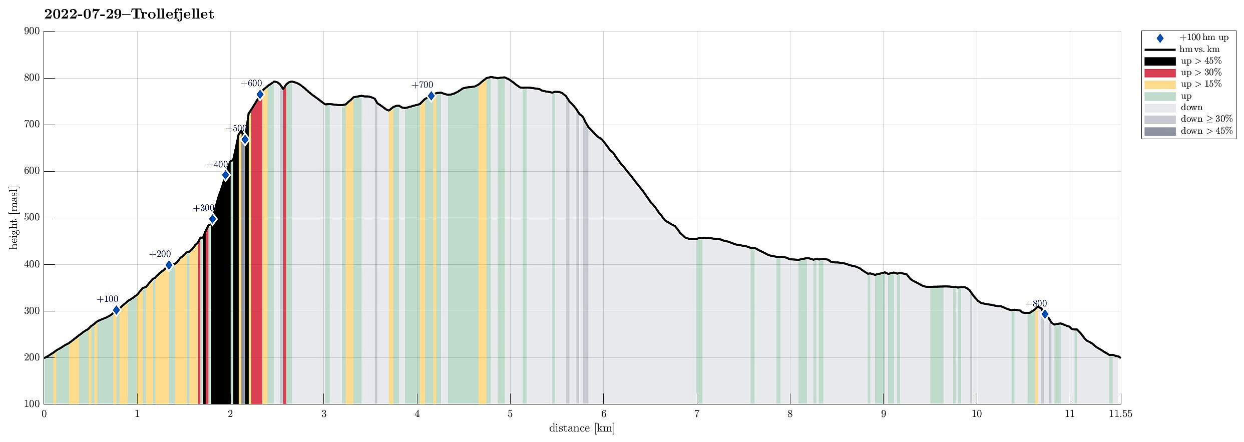
| Entfernung | 11,6km |
| Höhenmeter | 806m |
| GPS |
|
| Besteigungen | Trollefjellet (793m) | 29.07.2022 |
|---|---|---|
| Besuche anderer PBE | Utsikt Klenevatnet (803m) | 29.07.2022 |
Trip Summary
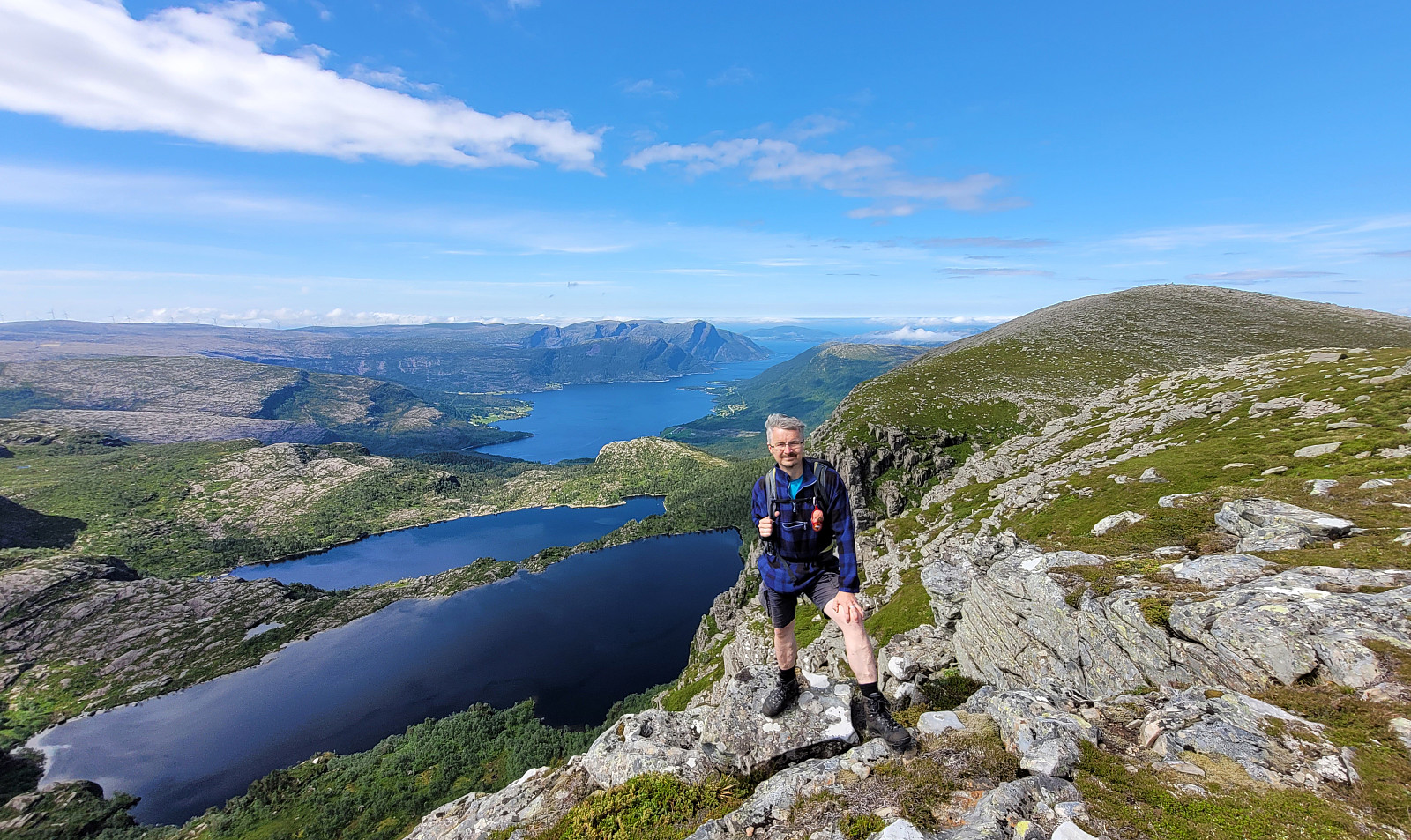
With all the many and wonderful mountains all around, we decided to not drive all too much and rather make a hike close to where we were staying. The impressive cliff of Trollefjellet immediately came to mind and after a short look at the map, it appeared possible to ascend to Trollefjellet via its western (steep!) ridge. After briefly consulting with one from Indrehus, we not only learned that he had made this ascent already before, but also got permission to drive up a little along the forest road in the south of Storeelva. This brought us up to about 200mosl (and quite a bit nearer to the cliff!) and we parked where the forrest road turns right, away from Storeelva and up Nevredalen. From there, we then followed the forrest road further up. This brought us almost perfectly to the saddle in the west of Trollefjellet (at about 400mosl). The remaining 400 height meters (from the saddle and up to the top of Trollefjellet) then turned out to be a nice little challenge. The ridge is substantially steep and in many places it seems as if there is only one way to make progress. At times, one can find small stones that clearly have been erected to indicate those spots, at other times, one needs to trust one's own reading of the terrain. Almost at every step, one can enjoy great views, both towards Midtgulen, but also in the other direction (southwards). All in all, this ascent is challenging, but at the same time a great experience! The last 100 height meters, then, become easy, again, and one can "walk out" to the top, enjoying the emerging new views (towards Rikeloftet, for example). Even though it had not taken us very long to get up to Trollefjellet, we still enjoyed a nice break on its top before continuing. The remainder of this hike was then first in southern direction (towards Indrehusbøra via the ridge south of Trollefjellet). Walking (very easily!) along this long ridge offers wonderful views over Fossedalen (and also towards the impressive Rikeloftet in the east)! Before then turning left (eastwards) and into Fagredalen, we first hiked a bit further southwards, catching a view to Svartevatnet before turning around. Getting down into Fagredalen was then a special experience, also, as we walked down over a very regular slope of rock, almost like a tilted, but otherwise perfect stone floor! Down in Fagredalen, we then wished to cross over Storeelva to find a trail on the other side (with the one from Indrehus we had discussed whether walking out Fagredalen on the southwestern side of Storeelva also would be good, getting the recommendation to not attempt it due to the many, large stones that are spread out there, after falling down from Trollefjellet). Since we did not immediately find a spot, where crossing over the stream would have been possible (without stepping into the water), we crossed Storeelva simply without shoes. On the other side, we then followed the trail out Fagredalen (in northward direction). This trail leads into the direction of Svelgen, so it became relevant for us to find a good spot for deviating from this main trail and head further westwards (and further down). While there seems to be a trail (or, maybe, a "trail"), we did not find it (or where not sure enough to have seen it) and so crossed over the area north of Storeelva without a trail (very easy, but also quite wet!). After passing over the wettest part, however, we found the trail. This brought us to a little side valley with a small cabin, also. In our discussion of this hike, earlier on, we had been told about a simple bridge over Storeevla somewhere between Ingebrekthola (on the north) and Storura (on the south). We thus deviated from the trail, again, and headed down the small valley to Storeelva. There, we then followed the stream downwards (in western direction) to find the bridge. And indeed, just a few hundred meters further down the stream, we found the bridge. Even though this bridge turned out to be (a) narrow and (b) hanging slanted to the side, just with a thin rope to hold on to, we still were glad to have it for crossing the stream (so much further down, Storeelva is already very dynamic, between large rocks, with lots of water!). On the other side, however, we found out that there was (almost) no continuation (the bridge ends on top of a large rock -- that's it!). To somehow continue nonetheless, however, we started to slowly cross over numerous large rocks, trying to avoid dangerous falls into the deep cracks between them. Eventually, we somehow managed to make a bit of progress towards the west. Then, after a short "bush war", through a rather dense section of the forest, we happily found the trail that we had been aiming at. This then made walking out Høgebakkane easy, again, and soon after we were back to our car. All in all, this hike over Trollefjellet really was a nice adventure! :-)
Photos
Selected photos are available as Google photo album.
Useful Resources
See also the related FB-page Hiking around Bergen, Norway.

Benutzerkommentare