A round west of Arna, including Stikka (27.03.2021)

| Startpunkt | Mjeldheimskleiva (115m) |
|---|---|
| Endpunkt | Mjeldheimskleiva (115m) |
| Tourcharakter | Bergtour |
| Tourlänge | 3h 00min |
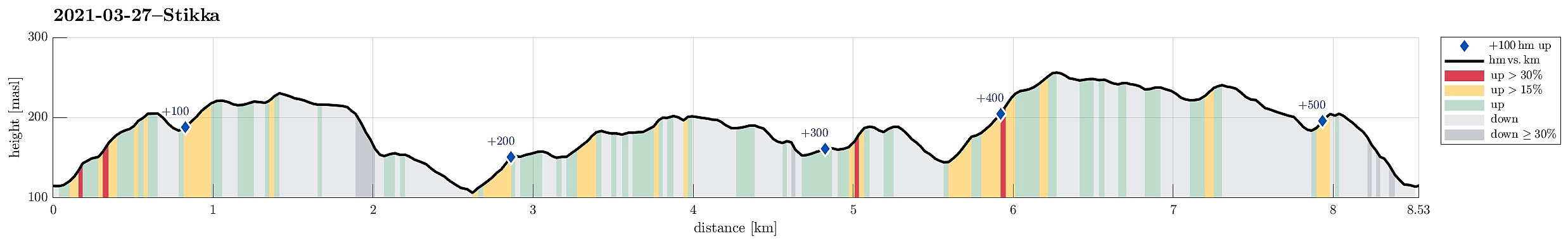
| Entfernung | 8,5km |
| Höhenmeter | 514m |
| GPS |
|
| Besteigungen | Fabiansvarden (186m) | 27.03.2021 |
|---|---|---|
| Merkeshaugen (232m) | 27.03.2021 | |
| Mjeldheimssåta (244m) | 27.03.2021 | |
| Stikka (258m) | 27.03.2021 | |
| Storsåta (206m) | 27.03.2021 | |
| Ullberget (192m) | 27.03.2021 | |
| Vårheia (211m) | 27.03.2021 |
Trip Summary
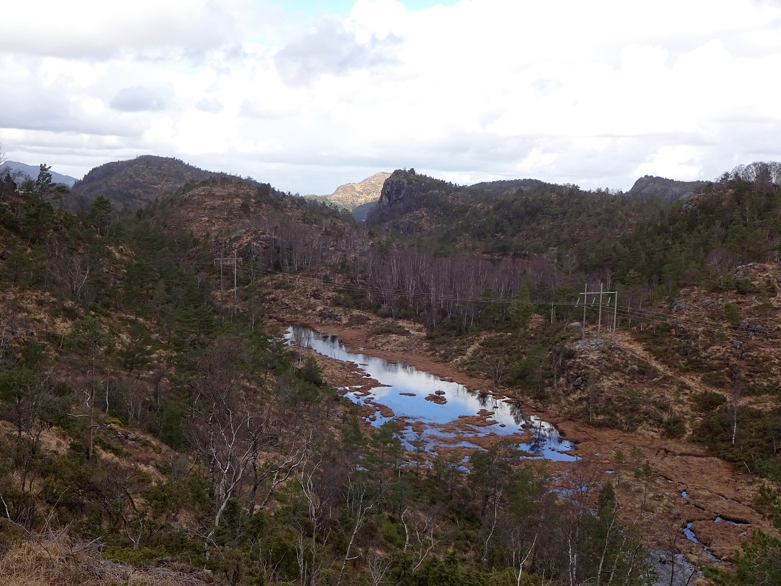
With the perspective of a half-dry, half-wet day ahead of us, we decided for another hike not too far from home. This time, our goal was to explore the hills in the west of Arna and Arnavågen. We thus left Bergen towards the east, aiming for Mjeldheimskleiva, where we parked just above Kleivadalen (in the west, a bit above Arna). We left the road basically where it crosses the little stream that comes down there from the northwest (and where the power line crosses the street, also). After some only 50 meters parallel to the stream, we started our (short) ascent to Vårheia (more or less directly in northern direction). On our way up there, we deviated a little from the trail and ascended across the southern ridge of Vårheia instead (also coming by a little cabin that can be found in the southeast of the "top" of Vårheia). Once over Vårheia, from which one has nice views down to Arna, we crossed Såteskaret to connect to Merkeshaugen in the north of Vårheia (staying on the eastern side of the power line). Continuing further north (into the direction of Grunnavatnet), we started our descent into a valley that leads down in southeastern direction. We then walked a little down this valley in order to connect to the trail that leads up to Gråberget from there. Via Gråberget we then connected to Fabiansvarden and from there further to Storsåta. There, we then started our way back, first southwards (in the east of Ullbergvatnet) to Vårheia (another Vårheia!). From Vårheia, we descended again into the direction of Grunnavatnet, but now from the north. About half way down, we turned right (into westwards direction). After a short while, we found ourselves on the not really planned ascent to Ullberget (now in the west of Ullbergvatnet). Since neither Ullberget is very high, we simply included it also into our little hike. :-) In fact, we then enjoyed a little break with some tasty snack on the northern side of Ullberget, before then getting "back on track" (south of Ullberget). After having crossed the stream that further down flows through Grunnavatnet we first ascneded to Eikeskaret and from there then further to Stikka (in southeastern direction). Crossing this minor top, we continued via Husheia along the ridge towards Mjeldheimssåta, which offers some nice views, also to Arna. Since the southern flank of Mjeldheimssåta is relatively steep (and the terrain was wet), we decided to walk around its northern side to get down and back to the car. After first walking a bit back towards the nearest saddle in the north of Mjeldheimssåta, we then turn right (in eastern direction) to get down into the little valley between Mjeldheimssåta and Såteskaret. Once there, we just crossed Vårheia (once again) to get back to Mjeldheimskleiva and to our car. All in all, and even though this area does not really offer high tops, we found this hike nice and refreshing.
Photos
Selected photos are available as Google photo album.
Useful Resources
See also the related FB-page Hiking around Bergen, Norway.

Benutzerkommentare