Nygårdsnipa and Gravdalsfjellet from Laksevåg (05.12.2020)

| Startpunkt | Eliasmarken (15m) |
|---|---|
| Endpunkt | Eliasmarken (15m) |
| Tourcharakter | Wanderung |
| Tourlänge | 2h 00min |
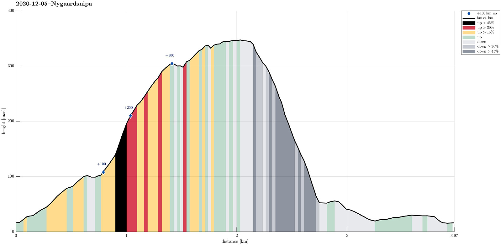
| Entfernung | 4,0km |
| Höhenmeter | 380m |
| GPS |
|
| Besteigungen | Gravdalsfjellet (353m) | 05.12.2020 |
|---|
Trip Summary
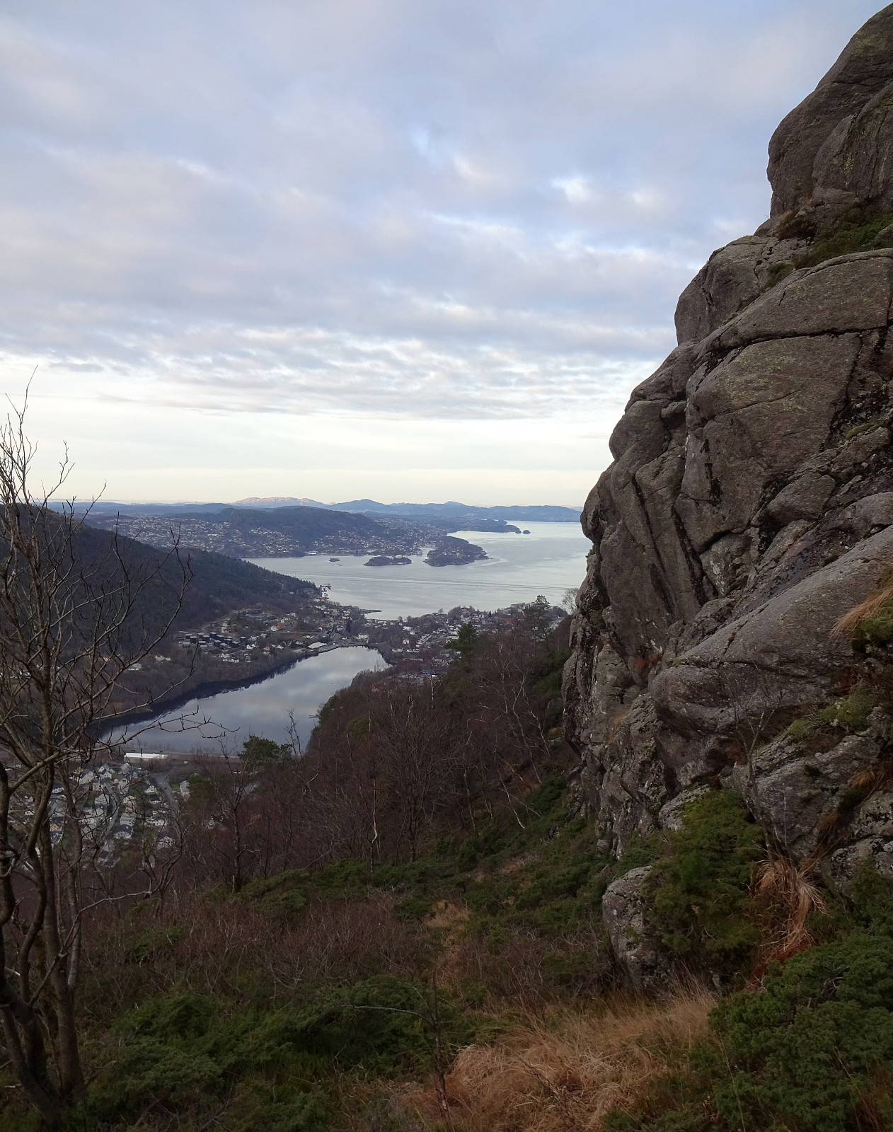
It was time for some new exploration in the city mountains of Bergen! :-) So we chose to ascend to Nygårdsnipa (and Gravdalsfjellet) from Laksevåg. We thus drove around and parked very near to where Damsgårdstunnelen ends on the western side (at Eliasmarken). Within a few steps, we started walking up (the quite steep) Nygårdslien. At the very upper end of Nygårdslien, one can conventiently enter the forest by stepping a little bit to the left at about 70mosl. But instead of following the trail, that extends from there up to the saddle between Holefjellet and Gravdalsfjellet, we crossed over (in southwestern direction) right above the highest houses at Nygårdslien. This first brought us to a little ridge (high above Lyngbøveien). From there, we first followed this ridge upwards (to about 125mosl), before connecting to another ridge (stepping up to it in southeastern direction to about 175mosl). Right east of this other ridge, a narrow but convenient valley is extending southwards (and steeply upwards), which brought us quite a bit closer to Nygårdsnipa quickly. From about 225mosl, we then crossed over and up to the ridge, leading directly up to Nygårdsnipa. After briefly enjoying the views from Nygårdsnipa, we continued towards Gravdalsfjellet, further in the south. Instead of following the trail that comes by Nygårdsnipa from Holefjellet, we stepped up to Gravdalsfjellet a little further to the west, with some great views from the top of the cliffs there! From Gravdalsfjellet, we had decided to try an even steeper descent than what we had stepped up, just a little further to the west of Nygårdsnipa! This side of Gravdalsfjellet is very steep indeed, with quite a number of cliffs, as well. When studying the map ahead of time, though, we saw a "diagonal" (pretty much extending "straight" northwards, right underneath a set of cliffs in the west of Gravdalsfjellet) that looked quite doable. To get there, we first followed a simple trail in northwestern direction from the top of Gravdalsfjellet, but instead of following it further, where it bends "left" (in western direction), we entered a little valley that sneaks around a big cliff in the northwest of Gravdalsfjellet. Right underneath the cliff, at about 325mosl in the west of it, we got the opportunity to step down (towards the west) and "enter" the diagonal that we had aimed for. Once on this "diagonal", we followed it further down (very steeply!), heading basically straight north. After carefully descending, we stepped out of the forest to road Nipedalen at about 50mosl. From there, we then just walked back to the car along roads Nipedalen and Lyngbøveien.
Photos
Selected photos are available as Google photo album.
Useful Resources
See also the related FB-page Hiking around Bergen, Norway.
Petter Bjørstad has a useful page about Gravdalsfjellet and also web page WestCoastPeaks.com provides useful information about Olsokfjellet, Gravdalsfjellet, and Damsgårdsfjellet.

Benutzerkommentare