Møsnuken from Gåssand (05.10.2019)

| Startpunkt | Gåssand (60m) |
|---|---|
| Endpunkt | Gåssand (60m) |
| Tourcharakter | Wanderung |
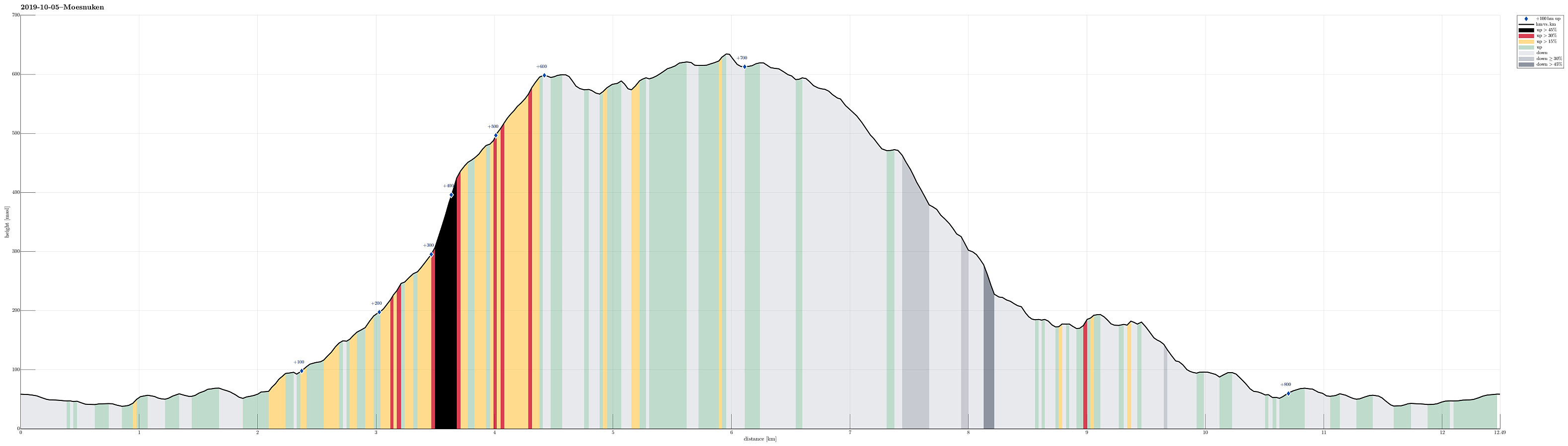
| Tourlänge | 5h 00min |
| Entfernung | 12,5km |
| Höhenmeter | 845m |
| GPS |
|
| Besteigungen | Møsnuken (639m) | 05.10.2019 |
|---|---|---|
| Storafjellet (592m) | 05.10.2019 | |
| Tyssdalsfjellet (605m) | 05.10.2019 |
Make sure that you are oriented well, appreciate hiking without any trail, and like stepping up/down in comparably steep terrain.
Trip Summary
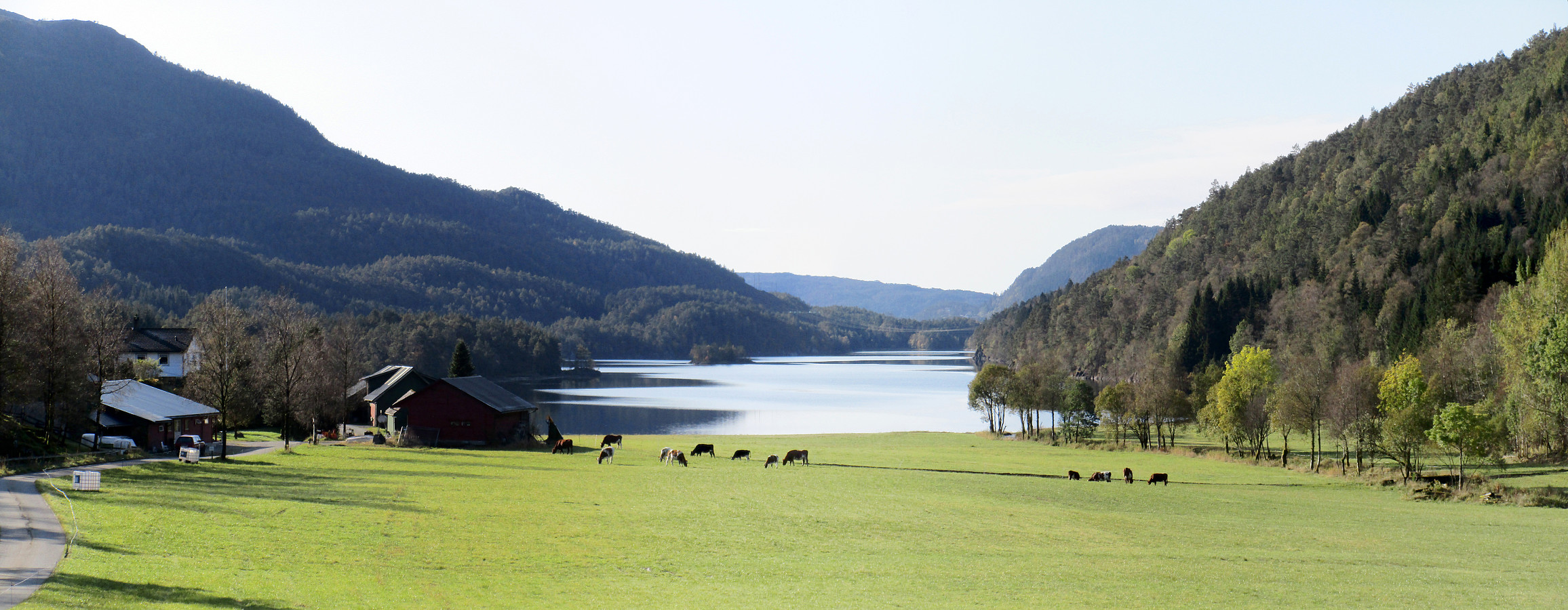
Møsnuken is very much worth a visit, not only for those who live in or around Osøyro. Usually, one would approach Møsnuken from the west (via Tyssdalen), or via Borgafjellet from Os. Less common is the approach from the north, i.e., from Gåssand. Some longer time back, we already tried this once, but failed (we had ended up at the northern side of Krokavatnet and did not see any reasonable way to get over it). So we decided to give this adventure another try! :-) Taking E39 southwards from Bergen, we turned left in Søfteland (where there's a sign towards Gåssand). As soon as one crosses Oselva one continues on the relatively narrow road Gåssandvegen in northeastern direction. After passing through a small valley (Lona) between Raudlifjellet (on the left) and Åsen (on the right), one turns right (and into southern direction), when getting close to Ytsta Raudlivatnet, crossing Nordelva there, also. We parked right next to the road about half way towards Gåssandvatnet (the road changes into a private road near this lake) and started our hike from there. First, we followed the road to Gåssandvatnet, coming by a bigger farm there. Once very near to the lake, it was important to turn right and cross Sagelva more or less where it flows into the lake. Further south, we followed a forest road that extends parallel to the lake (on its eastern side) until it comes close to Stokkedalselva. There, one has several options for continuing. We crossed Stokkedalselva and entered Stokkedalen (there then mostly in eastern direction, turning away from Gåssandvatnet). Not far into Stokkedalen, one again has several options (with one leaving to the left and into Øvreeidsdalen). We stayed on the southern side of the valley, continuing mostly into the direction of Langedalen. At about 160mosl, however, we followed the forest road away from Langedalen (then again more into eastern direction, into the direction of Lyhaugen). From about 200mosl and onwards, the situation becomes much more unclear (if one looks carefully, one can find and follow a trail there; but it's not really obvious). At about 300mosl, we deviated from the trail, since we got the impression that we could ascend nicely along the steep mountain side towards Tyssdalsfjellet. The next 150 height meters were then steeply upwards, in southern direction, stepping up a gress-covered slope. From up there, just above the tree line at about 450mosl, the continuation to Tyssdalsfjellet became easier, again, and fairly straight-forward. Soon later, we arrived at Tyssdalsfjellet and enjoyed excellent views from up there. In order to proceed to Møsnuken, we first needed to descend from Tyssdalsfjellet in southern direction, connecting to one of the main trails that come up there from the west (from Linken). From there, it was then straight-forward to Møsnuken (mostly in eastern direction). After a short rest at Møsnuken, enjoying also the wonderful view down to Fusafjorden, we started our descend (back towards Gåssand). Our plan was to hike a round and thus we continued from Møsnuken in northern direction (towards Gjelhaugen first). Leaving Møsnuken, we also left the trail (for a longer time). Since we had seen that this northern ridge of Møsnuken is quite steep on its western and eastern side, we aimed at hiking over the ridge (in northern direction) as long as possible. After having descended to about 475mosl, we had hiked a little too much to the left (northwest). Continuing into this direction would not have been a good idea (too steep terrain). Therefore, we crossed over to our right (in eastern direction) to reconnect with the ridge that extends further towards north (Lægdene). At about 325mosl, after having passed the tree line again, we then decided to turn left and follow a small valley further down (our next goal was Svartatjørna). Following this valley down was steep, but reasonably possible. At about 200mosl, the terrain got much flatter (and wetter) and proceeding got easier and faster. We followed the course of the water, more or less, and arrived at the southeastern end of Svartatjørna soon. From there, our plan was to cross over to Øvreeidsdalen and to find a trail there, which would bring us back to Stokkedalen (in southwestern direction). Rounding Svartatjørna in its east/northeast was a little more tricky than expected (but well possibe). North of Svartatjørna, we then ascended to a small saddle at about 185mosl. There, we got the impression that we could identify something like a trail (up to interpretation, though!). Whether trail or deer track, following this "something" in southwestern direction (along the southern side of Øvreeidsdalen) was relatively straight-forward and soon we arrived near the place where the stream from Svartatjørna meets the stream from Øvreeidstjørna. From there, it was then easy and straight-forward to the forest road in Stokkedalen. Once reconnected to the forest road, which we had used already before the ascent to Tyssdalsfjellet, we simply hiked back to the car the same route which we had followed (in the opposite direction) in the beginning. All in all, this was an interesting adventure: Finding a good ascent to Tyssdalsfjellet is probably crucial (was steep but very OK for us). Descending along the northern ridge of Møsnuken could easily become difficult, if one gets into too steep terrain (but avoiding too steep terrain is possible, especially when staying on the ridge). Finally, crossing the large forest in the south of Gåssand (in order to get back to Stokkedalen) was without any major trail and thus partially wild and also quite a bit wet, of course. Altogether, doing Møsnuken from the north is probably only recommended to those, who are ready to explore this region without a trail (at least for larger sections) and who are ready to do some hiking in relatively steep terrain.
Photos
Selected photos are available as Google photo album.
Useful Resources
See also the related FB-page Hiking around Bergen, Norway.
Petter Bjørstad has a useful page about Møsnuken and also web page WestCoastPeaks.com provides useful information about Møsnuken and Tyssdalsfjellet.
Web page UT.no from the Norwegian Trekking Association recommends a hike from Tyssdalen (via Linken).

Benutzerkommentare