Nonkletten, Sørkletten, and Klubben (05.10.2018)

| Startpunkt | Parking Kleppsvatnet (30m) |
|---|---|
| Endpunkt | Parking Kleppsvatnet (30m) |
| Tourcharakter | Bergtour |
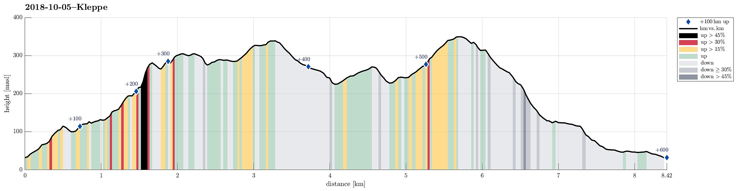
| Tourlänge | 3h 00min |
| Entfernung | 8,4km |
| Höhenmeter | 600m |
| GPS |
|
| Besteigungen | Klubben (352m) | 05.10.2018 |
|---|---|---|
| Nonkletten (313m) | 05.10.2018 | |
| Sørkletten (341m) | 05.10.2018 | |
| Besuche anderer PBE | Foss over Kleppsvatnet (110m) | 05.10.2018 |
| Parkering Kleppsvatnet (35m) | 05.10.2018 |
Note that this hike was mostly without any trail and the area is partly challenging (some cliffs, steep slopes, etc.).
Trip Summary
After a nice meeting in Fotlandsvåg, I wanted to use the afternoon to do a little hike nearby. Looking at the map, I got interested in a round near Kleppsvatnet, including Nonkletten, Sørkletten, and Klubben. I drove across Kleppsskaret and down to Kleppsvatnet (its southern end) and parked right next to the southernmost end of the lake.
Nonkletten
From there, I headed into the direction of Nonkletten, parallel to the lake. The first (short) stretch was still a forest road, leading up to a small saddle. On the other, northern side, the road turned more and more into water until it got completely exchanged for a little stream, coming down from the northeast (and heading towards Kleppsvatnet). I first followed the stream upwards through the forest, before I decided to aim at a higher route towards Nonkletten. Stepping through the moderately steep and pretty wild forest was OK, but of course slow. Not far from Nonkletten, almost exactly south of the top, I came by a high and steep cliff (to my right). I continued further upwards and ended up in the trough between Nonkletten and Sørkletten. Even though I checked carefully, while stepping further up, it appeared clear to me that the southern side of Nonkletten is simply to steep (at least near the saddle) for attempting any direct ascent. Thus, I continued further up through the trough and towards the saddle. Also the saddle is deeply cut in between both hills, not allowing any ascent to Nonkletten, neither! With some patience, I continued further (down on the other side) until I found some plastic marks that were attached to a few trees -- this clearly was a sign for a connection to the top and indeed, following these plastic pieces, I could get up to Nonkletten without any troubles. :-)
Sørkletten
After having tried to see something from Nonkletten (not easy, since this hill is completely overgrown with trees!), I decided to instead head for Sørkletten right away. I went back (following the plastic pieces) and crossed over to the over side, starting my ascent to Sørkletten. The northwestern side of Sørkletten is actually very nice, with fewer trees and some very nice views towards the north! Also hiking is much easier, once one is up there on the ridge and walking up to Sørkletten was quite enjoyable! :-)
Klubben
Since the overall condition was very wet, once I arrived on Sørkletten (both from above and from below), I decided to continue immediately into the direction of Klubben (in a way going "back", in parallel, to my ascent to Nonkletten). Walking down from Sørkletten, in southern direction, I tried to follow the ridge (more or less), holding the right direction towards Klubben. While the area was extensively covered by deer tracks (to the degree that I got the impression that it really hurts the forest up there!), no path was to be seen anyway between Sørkletten and Klubben. Instead, this passage was extremely wet, and it was good finally get back onto some slopes (up Klubben) with the occasional spot that was not covered with water.
Back via Budalen
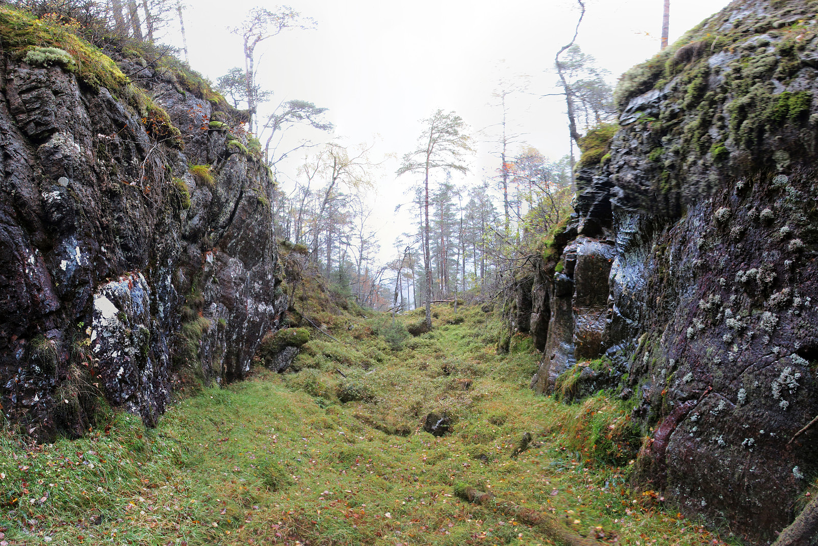
Klubben is not really a very remarkable top, but it is possible to see in different directions and I enjoyed some good views! Once on Klubben, my plan was to try an descent into Budalen on the southeastern side of Klubben. I was prepared to end up in some steeper terrain, but eventually, it was reasonably doable to descend through the forest into the valley. Budalen is then impressive, since its southwestern side is a long and tall cliff, towering over the valley. Once in the valley, I immediately found the path there and followed it towards Kleppe. Shortly before reaching the street, I left the path and descended to Ækretjønna directly. From there, I simply walked back the road and got to my car shortly after.
Conclusion
All in all, this was (a) a relatively wild hike (mostly without any path, occasionally in steep terrain, etc.), (b) a VERY wet hike (in addition to multiple rain showers during the hike, there was still a tremendous amount of water in the nature from previous precipitation, and (c) a good way to get a bit refreshed after one week of office work! :-)
Photos
Selected photos are available as Google photo album.
Useful Resources
See also the related FB-page Hiking around Bergen, Norway.
Petter Bjørstad has a useful page about Klubben and another one about Sørkletten, and also web page WestCoastPeaks.com provides useful information about Klubben and about Sørkletten.

Benutzerkommentare