Arkiv - dato
Arkiv - aktivitet
-
Annen vintertur (3)
- Trugetur (3)
- Fottur (137)
-
Kjøretur (1)
- Biltur (1)
-
Klatring (23)
- Alpin klatring (9)
- Sportsklatring (11)
- Via ferrata (2)
-
Skitur (62)
- Fjellskitur (3)
- Langrennstur (1)
- Randonnée/Telemark (58)


Lister jeg samler etter
-
Norges 1000 største fjell målt i primærfaktor
(45/1000)
 4%
4%

Favoritturer
Favorittopper


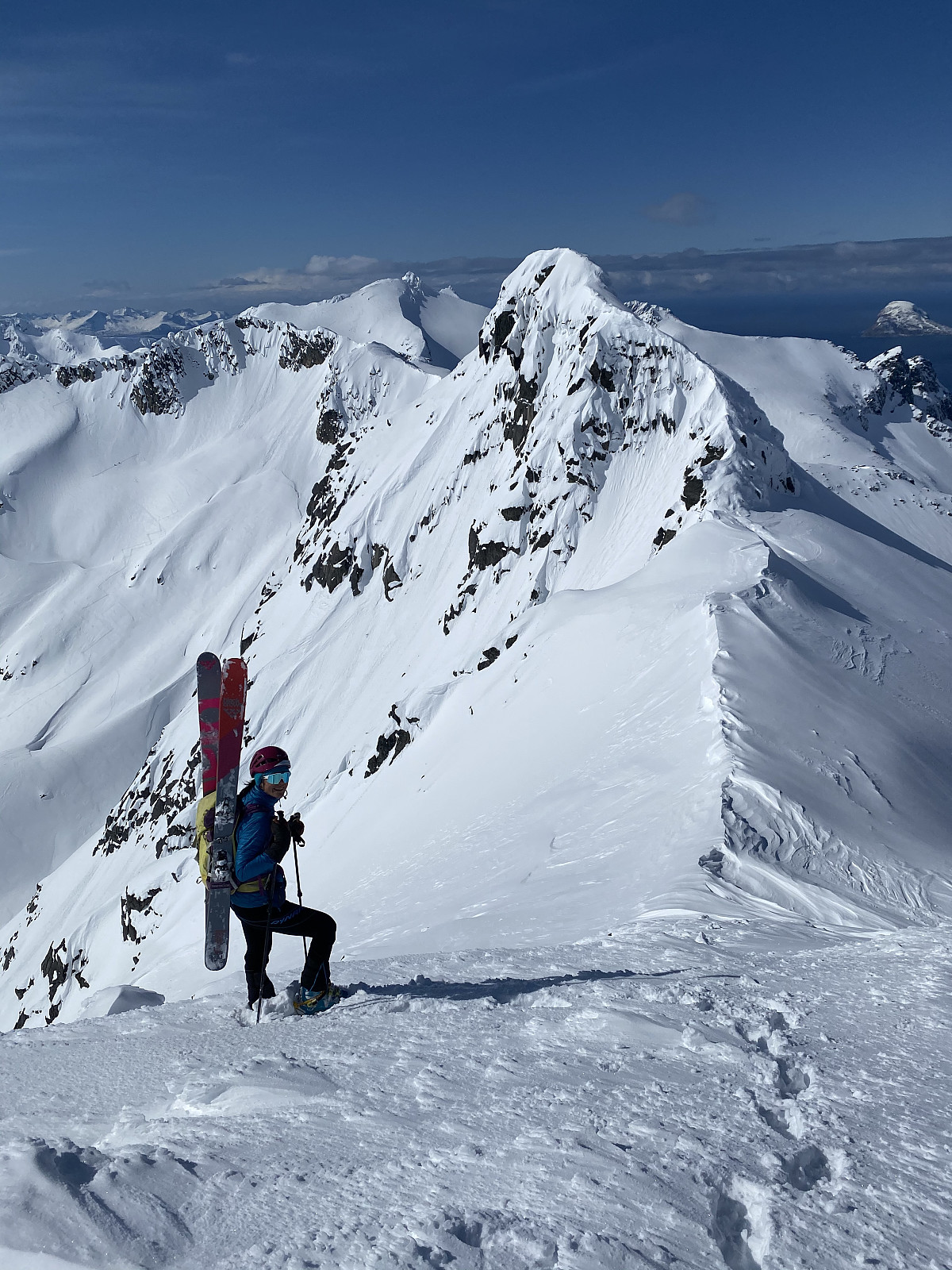
Styrmannstinden
- Dato:
- 13.05.2020
- Turtype:
- Randonnée/Telemark
- Turlengde:
- 4:00t
- Distanse:
- 7,7km
Lots of new snow on Monday & Tuesday meant I was looking forward to heading out when the clouds cleared on Wednesday afternoon. We parked just before the bend in the road at Vågbotn and headed up towards Styrmmanstinden. Fresh snow and no other tracks made for hard trail breaking work, and there was a lot more wind than forecasted. We gained elevation effectively, but it was tough on the legs making kick turn tracks through the steeper section. From the skare we got great views towards Hollendaren/Zapfetoppen and headed up the final section before the top. Parked the skiis around 50m from the top and walked the rest. Great views as always, but still freezing cold. Is summer coming soon?! Excellent skiing all the way down to the car, loose powder in the top few hundred meters and deep, >>>
Storsteinnestinden S-N Traverse
- Dato:
- 10.05.2020
- Turtype:
- Randonnée/Telemark
- Turlengde:
- 4:42t
- Distanse:
- 11,8km
 We parked one car at Ersfjordbotn and then drove to Kattfjordeidet, where we parked at the regular parking and headed up the normal route. Quite a few people already out, despite it being 9.30 on a Sunday. The trip up went quickly with good snow conditions, but the east facing slope up from the lake had quite a bit of wind transported snow on it. The last 50m or so elevation were quite icy, so here we put on the ski crampons to get to the top. Once we were at the top, Hannah headed down the north side to check out the conditions. It was looking a bit wind blown but we decided to give it a go. It was too icy and wind-packed that we could ski straight down from the top, so the skis went on the backpack while we headed down onto the flank. My crampon skills definitely need some work! From here >>>
Åborsdalstinden
- Dato:
- 02.05.2020
- Turtype:
- Randonnée/Telemark
- Turlengde:
- 4:17t
- Distanse:
- 9,8km
 We had originally planned to ascend Bjørnskarstinden via the north facing gully, but due to large cornices hanging over the route, we headed up Åborsdalstinden instead.
We parked at Nordre Åbordsneset and made tracks up on the right hand side of the river. After coming up on the ridge, we headed west in the valley and towards Soltindan. Once we got to the skare between Bjørnskarstinden and Åborsdalstinden, we could see huge cornices hanging over the east side of Soltindan and over the gully we were planning to ascend. With the first warm day in...forever? and sun, we decided today was not the day to be under so many cornices. We had around 400m of elevation to reach the summit of Åborsdalstinden, directly on our right, so we headed up there. Terrain between 30-40 degrees made for some >>>
We had originally planned to ascend Bjørnskarstinden via the north facing gully, but due to large cornices hanging over the route, we headed up Åborsdalstinden instead.
We parked at Nordre Åbordsneset and made tracks up on the right hand side of the river. After coming up on the ridge, we headed west in the valley and towards Soltindan. Once we got to the skare between Bjørnskarstinden and Åborsdalstinden, we could see huge cornices hanging over the east side of Soltindan and over the gully we were planning to ascend. With the first warm day in...forever? and sun, we decided today was not the day to be under so many cornices. We had around 400m of elevation to reach the summit of Åborsdalstinden, directly on our right, so we headed up there. Terrain between 30-40 degrees made for some >>>
Store Kjostinden
- Dato:
- 30.04.2020
- Turtype:
- Randonnée/Telemark
- Turlengde:
- 5:34t
- Distanse:
- 14,5km
Daltinden
- Dato:
- 29.04.2020
- Turtype:
- Randonnée/Telemark
- Turlengde:
- 7:00t
- Distanse:
- 20,7km
 We awoke to blue skies and sore feet! After such great powder on the north face of Tafeltinden yesterday, we decided Daltinden and its north aspect would be a good choice.
The 5km approach in the valley was tedious and painful, with hard and uneven conditions really hurting the blistered and bruised feet. We started gaining elevation after around 1.5 hours, and got our first glance at the bowl, and it looked like great snow. The views kept getting better and better, with more and more of the Jiehkkevarri massif creeping into sight. There was only a few sets of tracks heading down, and great flat tracks heading up, though the weather was a lot colder than we thought. We had quite a few stops to put on extra layers. The powder was incredible, easily some of the lightest and fluffiest I've ever >>>
We awoke to blue skies and sore feet! After such great powder on the north face of Tafeltinden yesterday, we decided Daltinden and its north aspect would be a good choice.
The 5km approach in the valley was tedious and painful, with hard and uneven conditions really hurting the blistered and bruised feet. We started gaining elevation after around 1.5 hours, and got our first glance at the bowl, and it looked like great snow. The views kept getting better and better, with more and more of the Jiehkkevarri massif creeping into sight. There was only a few sets of tracks heading down, and great flat tracks heading up, though the weather was a lot colder than we thought. We had quite a few stops to put on extra layers. The powder was incredible, easily some of the lightest and fluffiest I've ever >>>
Tafeltinden
- Dato:
- 28.04.2020
- Turtype:
- Randonnée/Telemark
- Turlengde:
- 5:47t
- Distanse:
- 17,7km
 hmsv1 (Hannah Vickers) and I had 3 days in Lyngen, and thought Tafeltinden would be a good first trip so we could check out the conditions on multiple aspects. We parked at the end of the road in Koppangen (now 100kr..) and followed the valley in towards Koppangsbreen. Cold air temperatures and some cloud cover meant the south sides of the valley and run out zones were not a big worry for us.
Once we came up onto the glacier we headed more or less directly west. Soon the Lenangstindane came into view which were absolutely breathtaking, combined with Stupetindane to the right and Jægervasstindane peeping through the clouds to the left. There was more cloud cover than was forecast, but the only other people we could see on the whole glacier was two men about half an hour in front of us, which was perfect because then >>>
hmsv1 (Hannah Vickers) and I had 3 days in Lyngen, and thought Tafeltinden would be a good first trip so we could check out the conditions on multiple aspects. We parked at the end of the road in Koppangen (now 100kr..) and followed the valley in towards Koppangsbreen. Cold air temperatures and some cloud cover meant the south sides of the valley and run out zones were not a big worry for us.
Once we came up onto the glacier we headed more or less directly west. Soon the Lenangstindane came into view which were absolutely breathtaking, combined with Stupetindane to the right and Jægervasstindane peeping through the clouds to the left. There was more cloud cover than was forecast, but the only other people we could see on the whole glacier was two men about half an hour in front of us, which was perfect because then >>>
Blåtinden
- Dato:
- 21.04.2020
- Turtype:
- Randonnée/Telemark
- Turlengde:
- 4:44t
- Distanse:
- 60,3km
Mellom hmsv1 (Hannah Vickers) og jeg, har vi prøvd oss på Blåtinden 7 ganger så langt i år, til å nå toppen kun 1 gang grunnet været. Heldigvis denne gangen var været upåklagelig. Fin tur til tops med hardt skaregjern føre fra ca. 650moh og oppover. Fin tørrsnø ned til bollen, men solen hadde fått tak tidligere i dagen og alt som lo i skygger ble ganske hardt. Det var fin vårsnø der det ikke var spor, men med mye trafikk tidligere i dagen, mye var oppkjørt og hardt. Artig når man glemmer å slå av klokke...Takk for en findag Hannah!

