Archive - Date
Archive - Activity
-
Bike trip (137)
- Bike trip - mixed (51)
- Bike trip - road (9)
-
Other trip (1)
- Kayaking (1)
-
Other winter trip (4)
- Snowshoe trip (4)
- Ski trip (4)
- Trip by foot (740)
Archive - Geography
Peakbook-Friends


Collected lists
-
Bergen ≥ 50m pf. og ≥ 100 m.o.h.
(87/89)
 97%
97% -
Most dominating tops of the Bergen peninsula
(68/75)
90%
-
Utvalgte topper og turmål i Bergen
(316/350)
90%
-
Alle topper i Bergen
(357/398)
89%
-
Opptur Bergen
(100/113)
88%
-
De syv fjell rundt Bergen
(6/7)
85%
-
Sund ≥ 50m pf.
(14/18)
77%
-
Os ≥ 50m pf.
(25/34)
73%
-
Søyler (fastmerker) i Bergen
(68/100)
68%
-
Fjell ≥ 50m pf.
(21/32)
65%

Hochstaff & Reisalpe from Ebenwaldhöhe
- Date:
- 27.09.2025
- Characteristic:
- Hike
- Duration:
- 4:00h
- Distance:
- 9.7km
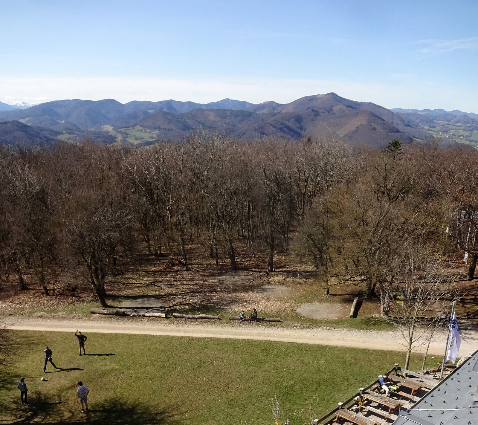
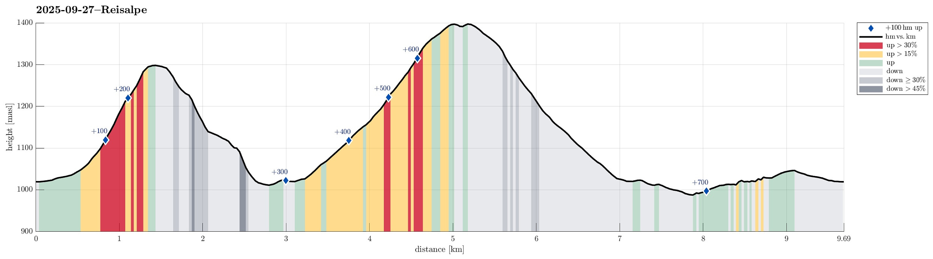 Expecting some nice weather on this Saturday, we aimed at a nice hike not too far from Vienna. After comparing a few opportunities, we ended up with driving to Ebenwaldhöhe in the west of Kleinzell and hiking from there to Reisalpe, also including an ascent to Hochstaff "on the way". For some 400 meters, we first followed a simple road, mostly in southern direction, across Ebenwaldhöhe, before then deviating from the main track (which leads around Hochstaff on its northwestern side) to include an ascent to Hochstaff, also. This route is not exactly well marked and one better knows where to go; despite of this detail, however, it's still all on proper trails to get up to Hochstaff from Ebenwaldhöhe (the ascent to Hochstaff is quite steep, but still nicely within "regular >>>
Ötscher via Rauher Kamm from Lackenhof
- Date:
- 21.09.2025
- Characteristic:
- Hike
- Duration:
- 6:00h
- Distance:
- 15.9km
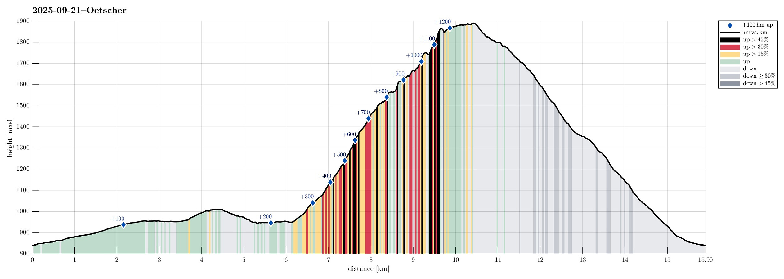 After spending the night involuntarily at an airport hotel in Amsterdam, we got to Vienna early on this Sunday, expecting a nice day. We thus rushed to get into the mountains, driving to Lackenhof in the southwest of Vienna. Our plan was to make a nice hiking round up and down Ötscher, using its northeastern ridge (Rauher Kamm) as the ascent route, while then descending via the Ötscherschutzhaus in the southwest of the mountain. Once in Lackenhof, we aimed at the large parking lot in Weitental to leave the car behind -- just to find that it was completely full with cars (while the combination of Sunday with nice weather and our relatively late arrival could have let us anticipate this situation, we had not). Luckily, one parking place got freed up only minutes after our arrival, letting >>>
Satzberg etc.
- Date:
- 16.03.2025
- Characteristic:
- Hillwalk
- Duration:
- 2:00h
- Distance:
- 9.0km
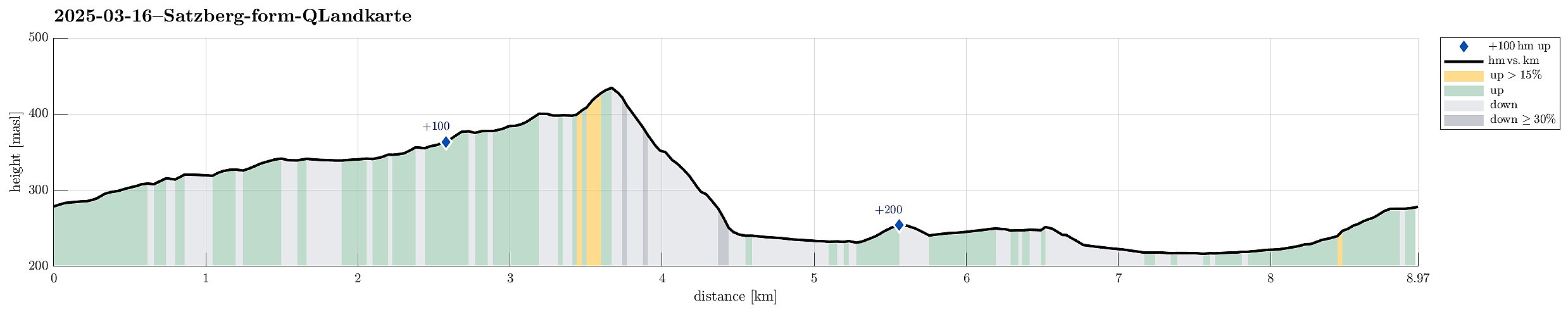 I wished to get some fresh air around my head and thus started a walk without a particular goal in the beginning. At first, I thought that it would be nice to pass by the Otto Wagner church "Am Steinhof" . From there, I continued northwards. But instead of following "the usual tracks" up to Jubiläumswarte , I eventually headed in a more westward direction with the goal to get up to Satzberg. From there, I found a new track (at least for me) down to Hüttelbergstraße. After taking a quick look at the Otto Wagner Villa of Ernst Fuchs -- just from the outside --, I then connected to the cemetary of Hütteldorf, before starting my return leg. Besides the generally nice walk, it also was nice to see the signs of spring (some nice flowers in the forest for example).
Selected photos are available as Google photo album .
See also the related FB-page Hiking around Bergen, Norway .
I wished to get some fresh air around my head and thus started a walk without a particular goal in the beginning. At first, I thought that it would be nice to pass by the Otto Wagner church "Am Steinhof" . From there, I continued northwards. But instead of following "the usual tracks" up to Jubiläumswarte , I eventually headed in a more westward direction with the goal to get up to Satzberg. From there, I found a new track (at least for me) down to Hüttelbergstraße. After taking a quick look at the Otto Wagner Villa of Ernst Fuchs -- just from the outside --, I then connected to the cemetary of Hütteldorf, before starting my return leg. Besides the generally nice walk, it also was nice to see the signs of spring (some nice flowers in the forest for example).
Selected photos are available as Google photo album .
See also the related FB-page Hiking around Bergen, Norway .
Lattermaißberg from Wiener Hütte
- Date:
- 16.07.2024
- Characteristic:
- Walk
- Duration:
- 1:30h
- Distance:
- 5.1km
 We wished to do a short, relaxed walk. Given the very warm weather, a walk in the forest seemed just right! :-)
See also the related FB-page Hiking around Bergen, Norway .
We wished to do a short, relaxed walk. Given the very warm weather, a walk in the forest seemed just right! :-)
See also the related FB-page Hiking around Bergen, Norway .
Rax from Preiner Gscheid
- Date:
- 15.07.2024
- Characteristic:
- Hike
- Duration:
- 6:30h
- Distance:
- 13.9km
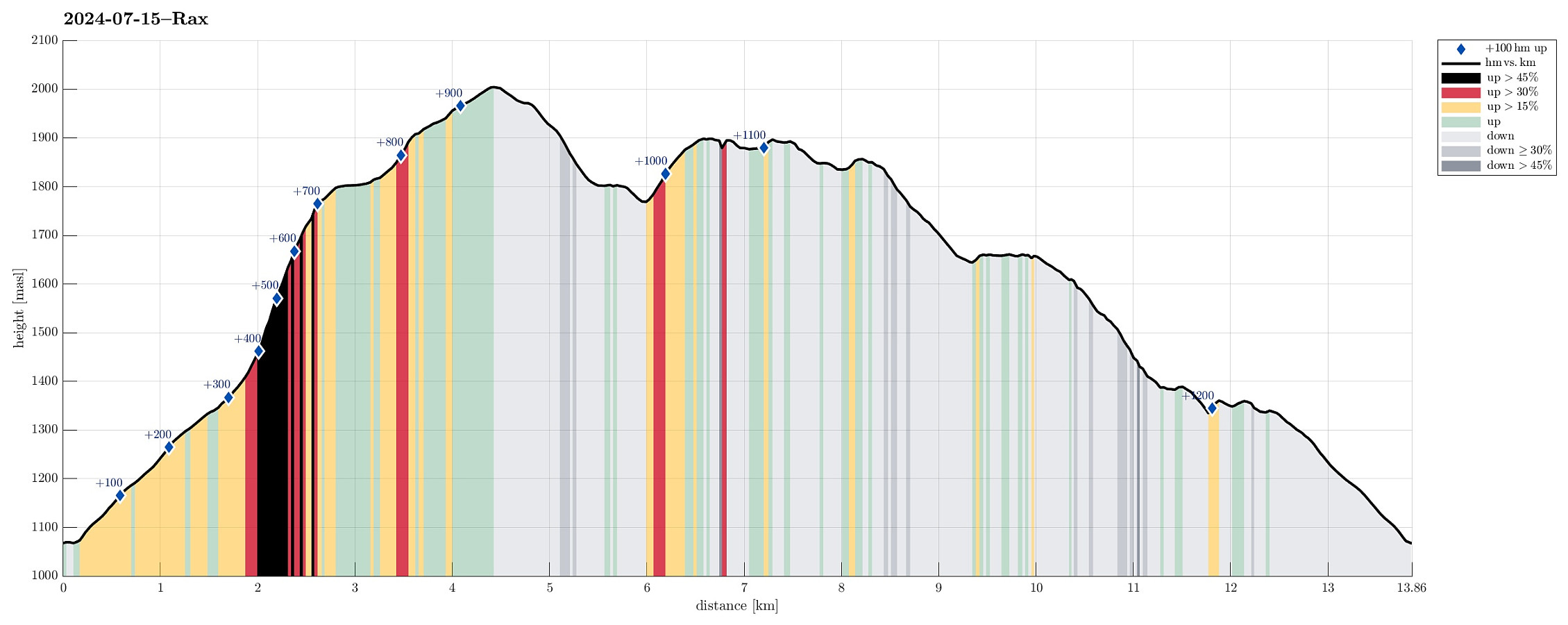 The weather looked promising (fine enough) to attempt the Rax, south of Wien. Starting early, we arrived at Preiner Gscheid (about 1070 masl) at about 8h30 in the morning. To make height meters quickly, we ascended (mostly northwards) along the skiing track that comes down in parallel to Rettenbach (in the northeast). At about 1340 masl (just a short distance from Waxrieglhaus in the east), we then entered Karlgraben in order to ascend (steeply) to Karl-Ludwig-Haus. We arrived at the Rax-heights at Thörl, before then walking over to Karl-Ludwig-Haus. From there, it's an easy stroll to Raxkircherl at Wetterkogel. Further upwards, we continued to Heukuppe via Schneegrubensattel. From there, we then returned to Karl-Ludwig-Haus, where we enjoyed a nice break with something to eat and drink. >>>
Nice family meeting at Peilstein
- Date:
- 03.03.2024
- Characteristic:
- Walk
- Duration:
- 4:00h
- Distance:
- 3.0km
 To celebrate a nice, round birthday, we gathered for a larger family meeting at Peilstein. After driving all the way up to Holzschlag, the walk up to Peilstein was short and easy (but still very nice!).
Selected photos are available as Google photo album .
See also the related FB-page Hiking around Bergen, Norway .
To celebrate a nice, round birthday, we gathered for a larger family meeting at Peilstein. After driving all the way up to Holzschlag, the walk up to Peilstein was short and easy (but still very nice!).
Selected photos are available as Google photo album .
See also the related FB-page Hiking around Bergen, Norway .
Longer walk to Rohrhaus and back
- Date:
- 27.12.2023
- Characteristic:
- Hike
- Duration:
- 4:00h
- Distance:
- 15.0km
 On this day, we thought that it was a nice idea to make an excursion to the Lainzer Tiergarten on the other side of the Wien-valley. We first headed towards Dehnepark, then down to Linzer Straße. After walking down Bergmillergasse for a short stretch, we used Brauhausbrücke to get over the Wien stream towards the other side. There, it was then only a few meters to get to Nikolaitor (and through it into Lainzer Tiergarten). Once in the park, we first passed by Nikolaikapelle, reading a bit about its very long history! Then, we started walking uphill along the Hackenbergweg (into the direction of Hagenberg). After visiting Hagenberg, just briefly, we continued, heading for a nice pace called Wiener Blick (for its nice view across Wien, of course). We then continued to Rohrhaus, before >>>
Excursion to Heuberg
- Date:
- 25.12.2023
- Characteristic:
- Hike
- Duration:
- 3:00h
- Distance:
- 10.4km
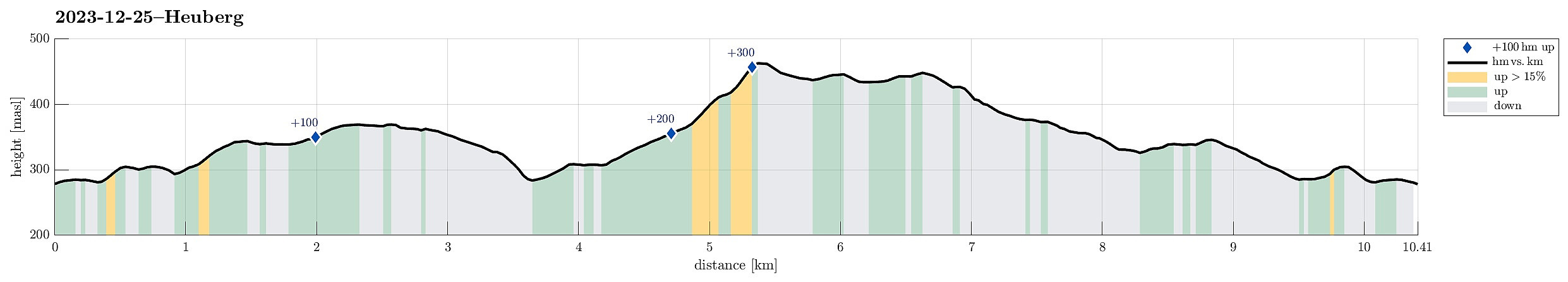 I wished to get some fresh air and so headed out for a walk. First, I headed towards Steinhof, walking across the green area towards the old fire station in the north of Steinhof. I then continued "in parallel" to Savoyenstraße, passing by the Schloss at Wilheminenberg soon after. Turning left, a bit further down, again, I stepped down Eselstiege (into the direction of Heuberg). On the other side, I followed two streets to get up to Röntgengasse. Walking up Röntgengasse, I got back into the forest (in the southeast of Heuberg). Following some minor trails, I quickly made it up "to the top" of Heuberg. From Heuberg, I then walked along the heights to Jubiläumswarte. From there, I "improvised" through Gemeindewald to get back. Crossing Loiblstraße in >>>
Round via Satzberg and Jubiläumswarte
- Date:
- 22.12.2023
- Characteristic:
- Hike
- Duration:
- 2:00h
- Distance:
- 6.3km
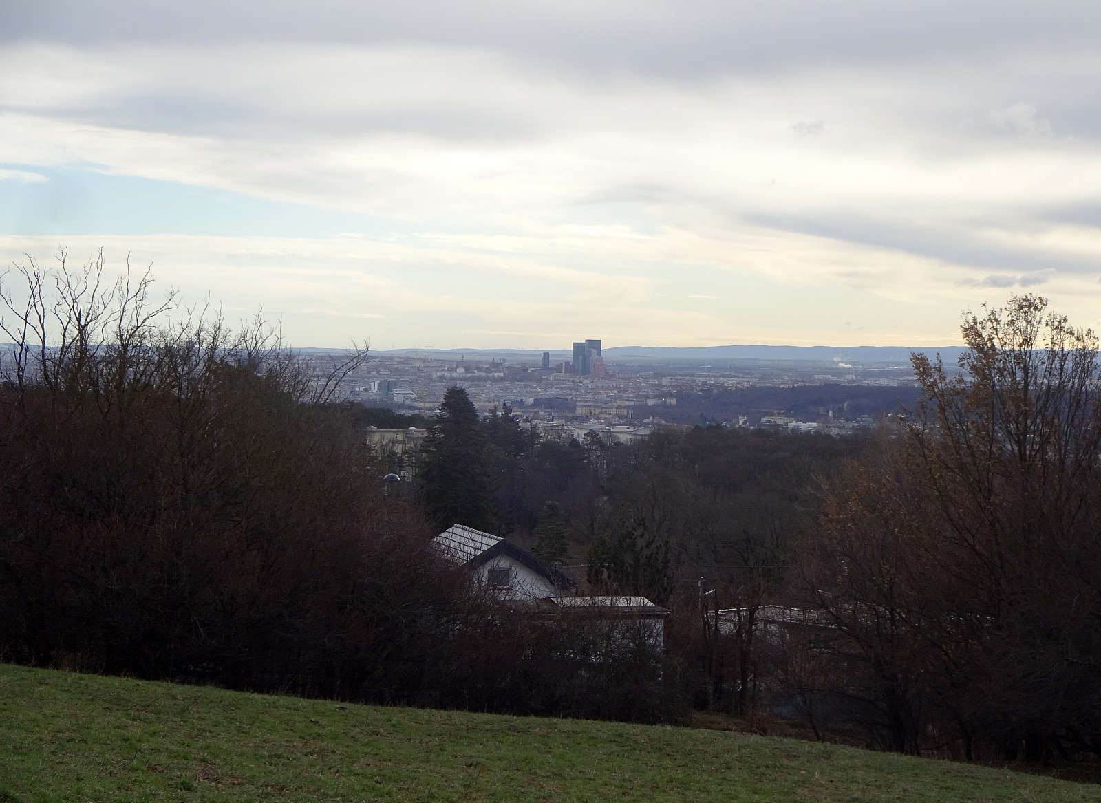 We wanted to get some fresh air and thus headed towards Dehnepark, first. After briefly walking upwards "in the bottom" of Dehnepark, passing by the little lake (on its western side), we crossed over Rosentalgasse to start an ascent towards Satzberg. A bit further up, we also crossed Steinböckengasse. From there, it was then basically further northwards to get all the way up to Satzberg. While one can enjoy some nice views across Wien from the ascent, the actual top of Satzberg is not exciting (and also without views, due to all the trees). From Satzberg, we then transitioned over to Jubiläumswarte (in the north, northeast of Satzberg). Then, it was mostly to walk back, first towards Steinhof.
Selected photos are available as Google photo album .
See also the related FB-page Hiking around Bergen, Norway .
We wanted to get some fresh air and thus headed towards Dehnepark, first. After briefly walking upwards "in the bottom" of Dehnepark, passing by the little lake (on its western side), we crossed over Rosentalgasse to start an ascent towards Satzberg. A bit further up, we also crossed Steinböckengasse. From there, it was then basically further northwards to get all the way up to Satzberg. While one can enjoy some nice views across Wien from the ascent, the actual top of Satzberg is not exciting (and also without views, due to all the trees). From Satzberg, we then transitioned over to Jubiläumswarte (in the north, northeast of Satzberg). Then, it was mostly to walk back, first towards Steinhof.
Selected photos are available as Google photo album .
See also the related FB-page Hiking around Bergen, Norway .
Großglockner from Ködnitztal
- Date:
- 17.07.2016
- Characteristic:
- Hillwalk
- Duration:
- 12:00h
- Distance:
- 15.7km
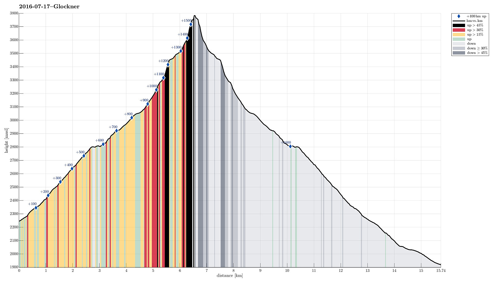 We started from Lucknerhaus, where a nice guy drove us up to Lucknerhuette (in order to give us an easy start into this hike)! From Lucknerhuette, we did a relaxed walk up to the Fanatscharte (and Stuedlhuette, there). On Stuedlhuette, we met our guide (from the Kalser Bergfuehrer) and discussed the weather (it really did not look promising, both in terms of rain/snow and also wind). After some thinking, we decided to still make an attempt, at least up to Adlersruhe (and Erzherzog-Johann-Huette, there). We started (into the freezing rain) and followed the "Normalweg", which leads around Schere, first, before then ascending on the upper-left side of Koednitzkees, before crossing over (to the east), leaving the glacier there, and continuing as a moderately easy climibing stretch >>>
