Archive - Date
Archive - Activity
-
Bike trip (137)
- Bike trip - mixed (51)
- Bike trip - road (9)
-
Other trip (1)
- Kayaking (1)
-
Other winter trip (4)
- Snowshoe trip (4)
- Ski trip (4)
- Trip by foot (740)
Archive - Geography
Peakbook-Friends


Collected lists
-
Bergen ≥ 50m pf. og ≥ 100 m.o.h.
(87/89)
 97%
97% -
Most dominating tops of the Bergen peninsula
(68/75)
90%
-
Utvalgte topper og turmål i Bergen
(316/352)
89%
-
Alle topper i Bergen
(357/400)
89%
-
Opptur Bergen
(100/113)
88%
-
De syv fjell rundt Bergen
(6/7)
85%
-
Sund ≥ 50m pf.
(14/18)
77%
-
Os ≥ 50m pf.
(25/34)
73%
-
Søyler (fastmerker) i Bergen
(68/100)
68%
-
Fjell ≥ 50m pf.
(21/32)
65%

Short round around Varden
- Date:
- 18.04.2026
- Characteristic:
- Walk
- Duration:
- 0:45h
- Distance:
- 2.1km
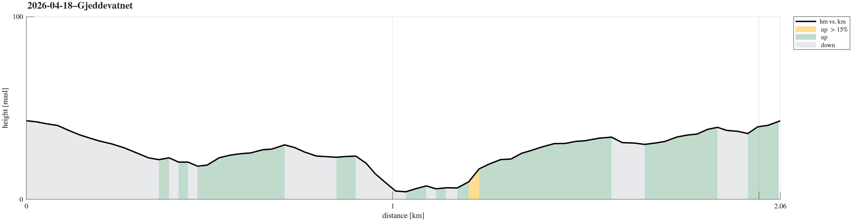 Just an evening walk around Varden, including a short visit to Gjeddevatnet.
See also the related FB-page Hiking around Bergen, Norway .
Just an evening walk around Varden, including a short visit to Gjeddevatnet.
See also the related FB-page Hiking around Bergen, Norway .
Nice round around Småvatnet near Alvøen
- Date:
- 21.02.2026
- Characteristic:
- Walk
- Duration:
- 2:00h
- Distance:
- 6.6km
 There was an idea of spring in the air and so we decided to make a round around Småvatnet near Alvøen. We parked in the north, right next to Alvøveien, not far from the soccer fields there. To get south towards Småvatnet, we first crossed over Ospehaugen. Further south, we then started our round around the lake by exploring the small peninsular in the west of Slettebakksvika. Next was then to walk around Slettebakksvika and heading further south on the east-side of Småvatnet. This stretch is a bit interesting, since one has to find a way to get through (with quite some cliffs connecting more or less directly to Småvatnet). Since we had done this before, we knew that it could be done, and so it was without difficulties that we made it to Gullaksdalen. From there, we then followed >>>
Oasen from/to Varden
- Date:
- 30.01.2026
- Characteristic:
- Walk
- Duration:
- 1:00h
- Distance:
- 4.7km
 I had something to do at "central Fyllingsdalen" (Oasen), so I decided to just walk there (and back).
See also the related FB-page Hiking around Bergen, Norway .
I had something to do at "central Fyllingsdalen" (Oasen), so I decided to just walk there (and back).
See also the related FB-page Hiking around Bergen, Norway .
Gjeddevatnet and back
- Date:
- 13.12.2025
- Characteristic:
- Walk
- Duration:
- 0:30h
- Distance:
- 1.9km
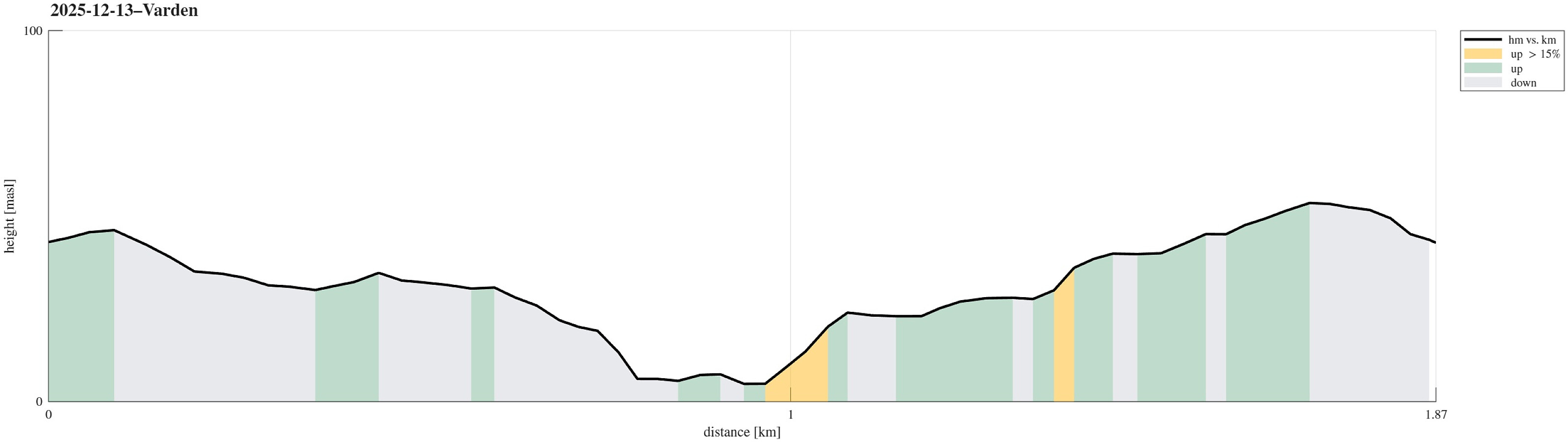 It was just to stretch our legs a little: quickly to Gjeddevatnet and back! :-)
See also the related FB-page Hiking around Bergen, Norway .
It was just to stretch our legs a little: quickly to Gjeddevatnet and back! :-)
See also the related FB-page Hiking around Bergen, Norway .
Exploring Amsterdam by foot
- Date:
- 11.11.2025
- Characteristic:
- Walk
- Duration:
- 2:30h
- Distance:
- 9.2km
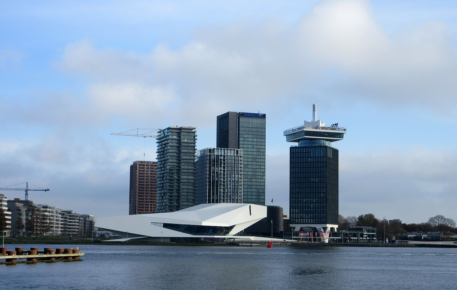 Our plan was first to visit the Van Gogh museum of Amsterdam. Enjoying a nice autumn day, we walked there from the hotel. The musuem, however, was sold out -- yes -- and thus we made a new plan: exploring some additional corners of Amsterdam by foot.
Selected photos are available as Google photo album .
See also the related FB-page Hiking around Bergen, Norway .
Our plan was first to visit the Van Gogh museum of Amsterdam. Enjoying a nice autumn day, we walked there from the hotel. The musuem, however, was sold out -- yes -- and thus we made a new plan: exploring some additional corners of Amsterdam by foot.
Selected photos are available as Google photo album .
See also the related FB-page Hiking around Bergen, Norway .
City walk through Delft
- Date:
- 03.10.2025
- Characteristic:
- Walk
- Duration:
- 2:30h
- Distance:
- 9.2km
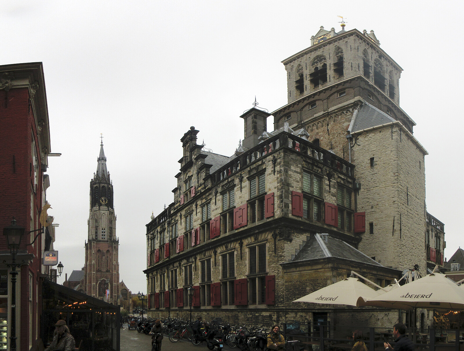 Having a bit of extra time on my hand, I decided to explore Delft a little (despite the clearly rainy weather). This brought me both to the campus of TU Delft, as well as into the center of Deft (twice), including Oude Delft, Markt, Beestenmarkt, etc. :-)
Selected photos are available as Google photo album .
See also the related FB-page Hiking around Bergen, Norway .
Having a bit of extra time on my hand, I decided to explore Delft a little (despite the clearly rainy weather). This brought me both to the campus of TU Delft, as well as into the center of Deft (twice), including Oude Delft, Markt, Beestenmarkt, etc. :-)
Selected photos are available as Google photo album .
See also the related FB-page Hiking around Bergen, Norway .
Golta in mixed weather
- Date:
- 31.08.2025
- Characteristic:
- Walk
- Duration:
- 2:00h
- Distance:
- 5.0km
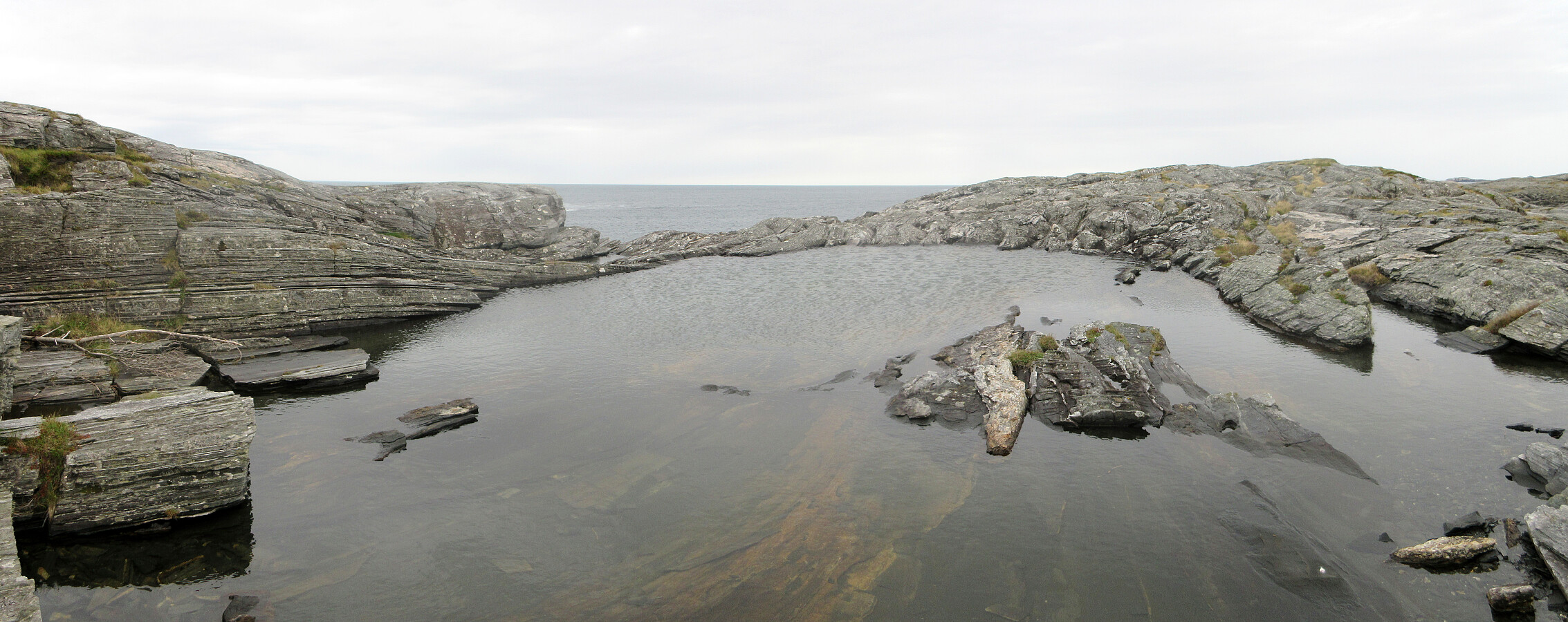 With a rather mixed weather forecast, we wished to make a brief excursion to the Atlantic and chose Golta as our goal. After driving there from Bergen and parking at Goltavegen, right between Vogga in the west and Goltosen in the east, we walked towards the coast from there, first following the marked trail. To get around Lutavika, we then followed the coast in norther direction, crossing over to the northwestern part of Golta at the southern end of Jonsvikadalen. On the other side, we then first visited a nice vista point south of Luten, before walking further to Sandvika. There, we basically turned around, then following the marked trail all the way back to the parking place. Given that the day was overall rainy, we actually had quite OK weather and enjoyed this short walk very much! >>>
Turku Saturday morning walk
- Date:
- 30.08.2025
- Characteristic:
- Walk
- Duration:
- 4:00h
- Distance:
- 15.9km
 I had a few morning hours on this Saturday before heading back to Bergen, which I wished to use for a walk to see a bit of Turku. I started by crossing the Aura river at Kirjastosilta, heading to the Samppalinnanvuori vantage point for a first view across the city. From there, my next goal was the hill-top Luolavuori, hoping for some additional views from up there. While stepping up there, I also looked at the enormous water tower not far from the hill-top. On my way down from Luolavuori, I then passed by an impressive boulder, right north of the water tower, that apparently a glacier left there a long time ago. My next goal was then to cross the Aura river using the small ferry Föri, but when I got there, I learned that it was not operated, unfortunately. I thus decided to walk around >>>
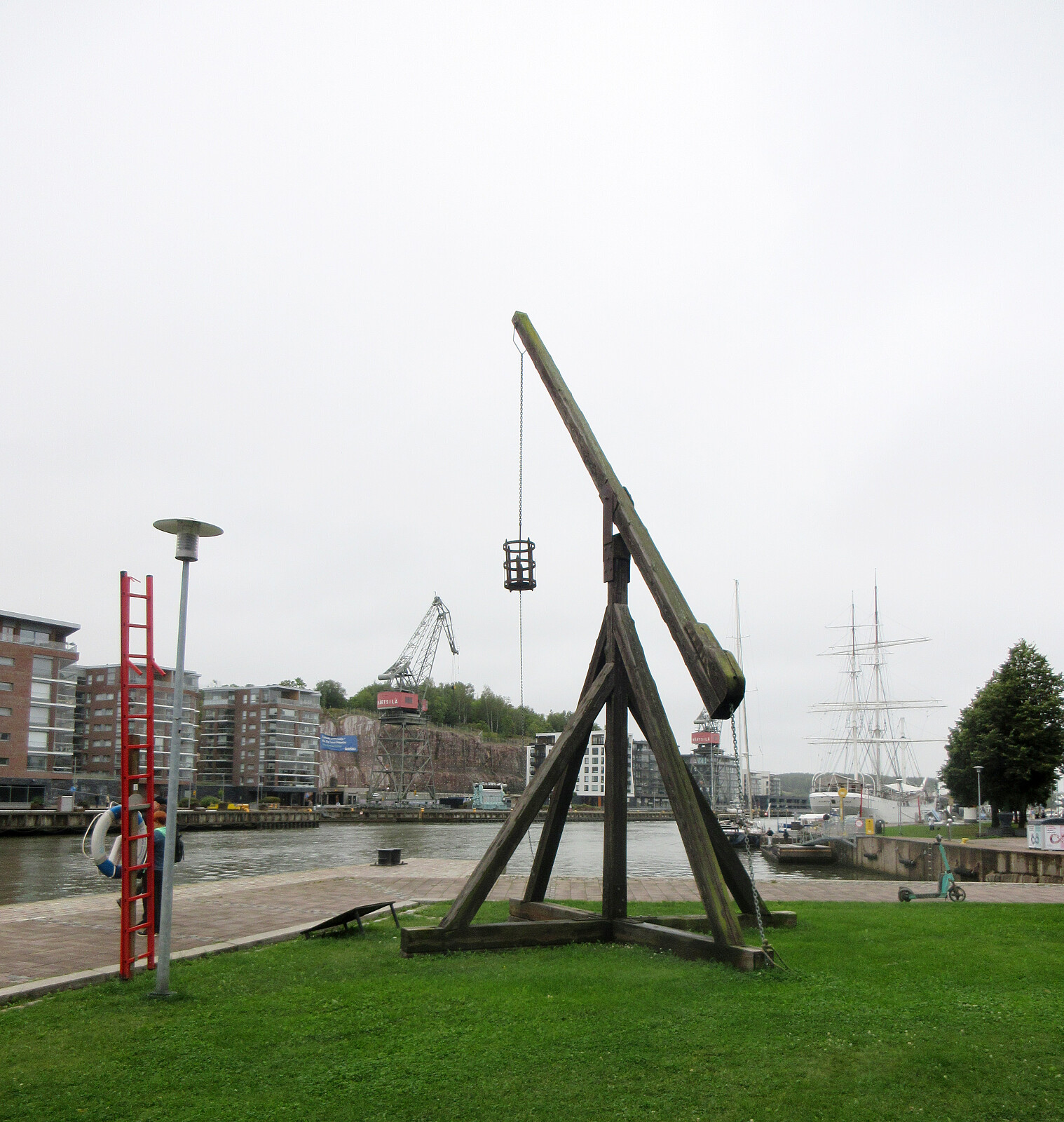
Exploring Suomenlinna south of Helsinki
- Date:
- 12.07.2025
- Characteristic:
- Walk
- Duration:
- 2:30h
- Distance:
- 5.8km
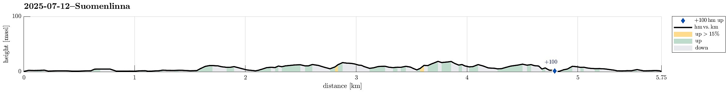 Our travel itinerary included about 24 hours in Helsinki before the follow-up flight further west. Exploiting our massive time confusion -- 6 am in Helsinki was like noon-time in Tokyo, after all -- we headed straight for the city center of Helsinki and from their, using the public ferry, to Suomenlinna, i.e., an island a bit south of the center of Helsinki, which previously was fortified massively. Today, quite a few visit this island, apparently, to see these fortifications. Before mostly following the "main-trail" across the island, we included a short detour to Pikku-Musta and Länsi-Musta, also. At the southern-most part of Suomenlinna, we then made a round around the fortifications before head back to the ferry quay where we had arrived earlier.
Selected photos are available >>>
Our travel itinerary included about 24 hours in Helsinki before the follow-up flight further west. Exploiting our massive time confusion -- 6 am in Helsinki was like noon-time in Tokyo, after all -- we headed straight for the city center of Helsinki and from their, using the public ferry, to Suomenlinna, i.e., an island a bit south of the center of Helsinki, which previously was fortified massively. Today, quite a few visit this island, apparently, to see these fortifications. Before mostly following the "main-trail" across the island, we included a short detour to Pikku-Musta and Länsi-Musta, also. At the southern-most part of Suomenlinna, we then made a round around the fortifications before head back to the ferry quay where we had arrived earlier.
Selected photos are available >>>
Round around the Imperial Palace (and Kanda)
- Date:
- 11.07.2025
- Characteristic:
- Walk
- Duration:
- 7:00h
- Distance:
- 13.1km
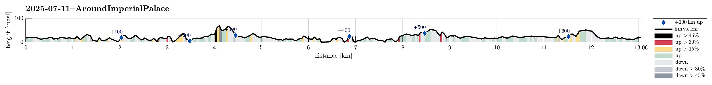 We had still some time before our flights back to Europe and thus made an attempt to see the Imperial Palace in Tokyo. Apparently, however, we seemingly had looked up the wrong information ahead of time -- just to find out that the very Palace was closed. We thus decided to walk around the Palace area, which also turned out as an interesting walk. With even more time left, we then added a short extra-loop to get an impression of Kanda, just north of the main railway station of Tokyo. Clearly, Tokyo has a lot variety to offer! :-)
Selected photos are available as Google photo album .
See also the related FB-page Hiking around Bergen, Norway .
We had still some time before our flights back to Europe and thus made an attempt to see the Imperial Palace in Tokyo. Apparently, however, we seemingly had looked up the wrong information ahead of time -- just to find out that the very Palace was closed. We thus decided to walk around the Palace area, which also turned out as an interesting walk. With even more time left, we then added a short extra-loop to get an impression of Kanda, just north of the main railway station of Tokyo. Clearly, Tokyo has a lot variety to offer! :-)
Selected photos are available as Google photo album .
See also the related FB-page Hiking around Bergen, Norway .
