Arkiv - dato
Arkiv - aktivitet
-
Annen tur (1)
- Kajakkpadling (1)
-
Annen vintertur (3)
- Trugetur (3)
- Fottur (615)
-
Skitur (3)
- Fjellskitur (3)
-
Sykkeltur (94)
- Blandet sykling (22)
- Gatesykling (2)
Arkiv - Etter geografi
"Peakbookvenner"


Lister jeg samler etter
-
Bergen ≥ 50m pf. og ≥ 100 m.o.h.
(81/89)
 91%
91% -
Opptur Bergen
(98/113)
86%
-
De syv fjell rundt Bergen
(6/7)
85%
-
Most dominating tops of the Bergen peninsula
(63/75)
84%
-
Utvalgte topper og turmål i Bergen
(244/306)
79%
-
Sund ≥ 50m pf.
(14/18)
77%
-
Alle topper i Bergen
(272/350)
77%
-
Os ≥ 50m pf.
(23/34)
67%
-
Hytter og objekter i Byfjellene
(66/101)
65%
-
Midthordland PF>= 100m
(73/115)
63%

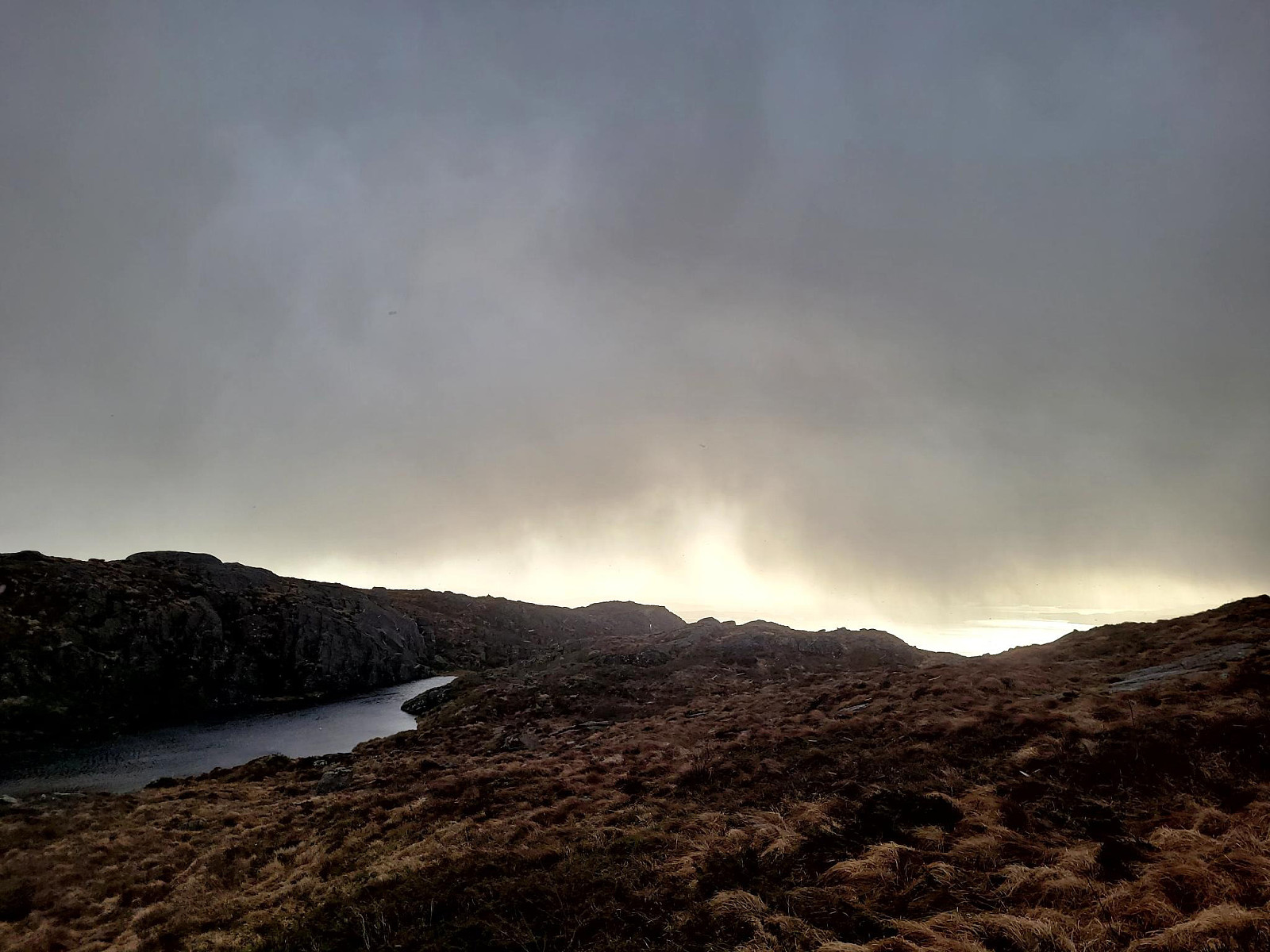
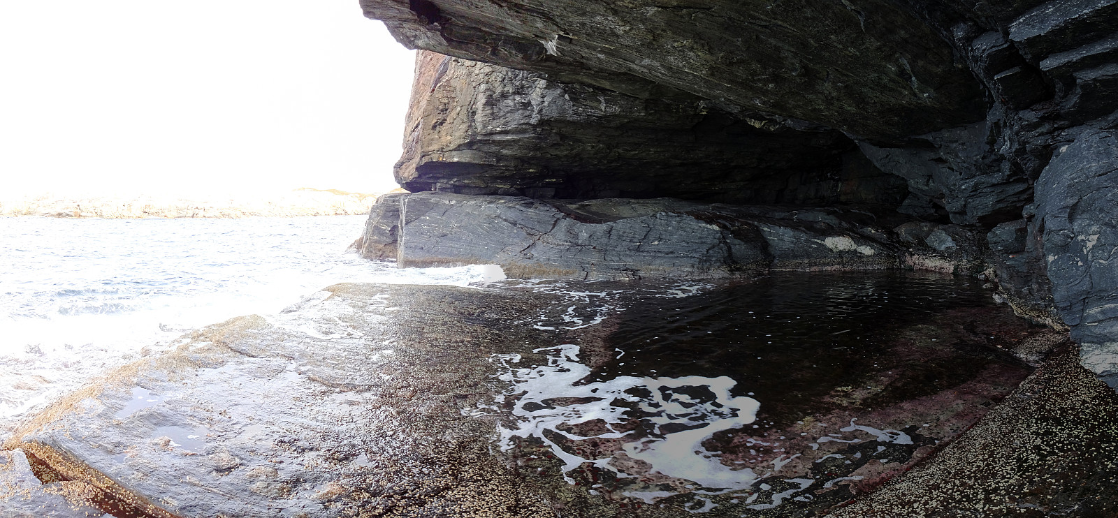
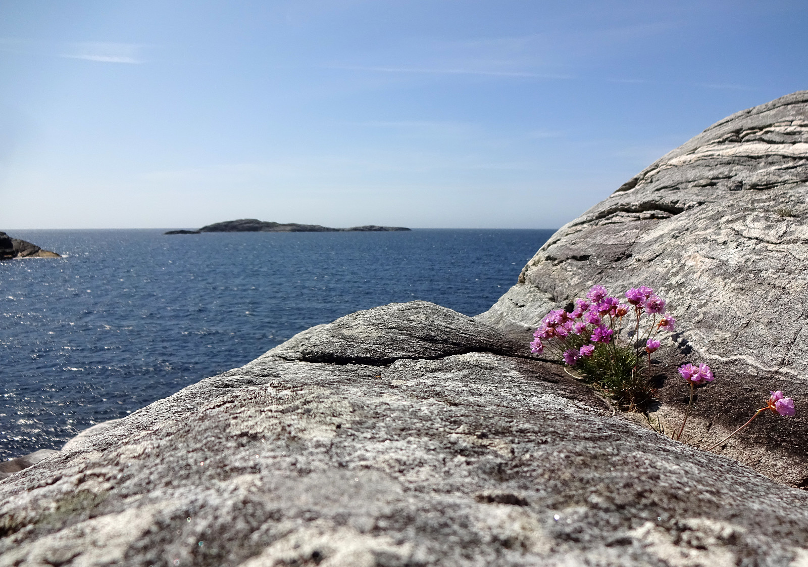
Bekhilderen at low tide
- Dato:
- 20.04.2024
- Turtype:
- Fjelltur
- Turlengde:
- 3:00t
- Distanse:
- 6,8km
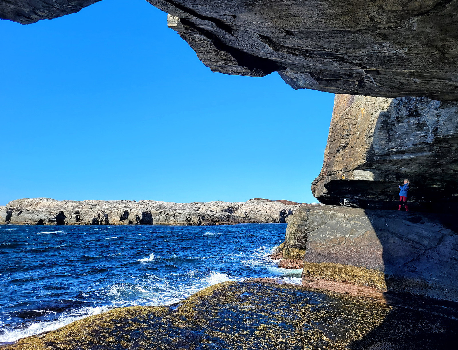 Planning our timing just right, we decided to visit Bekhilderen at low tide. We parked along Telavågvegen and followed first the road Håvarden. This brought us to the old mill at Selståvågen. From there, we followed the trail first to Grunnevågen and then further, on the other, southern side, to Bekhilderen. After having some good time there, we returned, basically following the same route "backwards". :-)
Selected photos are available as Google photo album .
See also the related FB-page Hiking around Bergen, Norway .
Web page UT.no from the Norwegian Trekking Association recommends a similar hike .
Planning our timing just right, we decided to visit Bekhilderen at low tide. We parked along Telavågvegen and followed first the road Håvarden. This brought us to the old mill at Selståvågen. From there, we followed the trail first to Grunnevågen and then further, on the other, southern side, to Bekhilderen. After having some good time there, we returned, basically following the same route "backwards". :-)
Selected photos are available as Google photo album .
See also the related FB-page Hiking around Bergen, Norway .
Web page UT.no from the Norwegian Trekking Association recommends a similar hike .
Sauafjellet and Spjeldsfjellet
- Dato:
- 25.03.2024
- Turtype:
- Fottur
- Turlengde:
- 3:30t
- Distanse:
- 9,9km
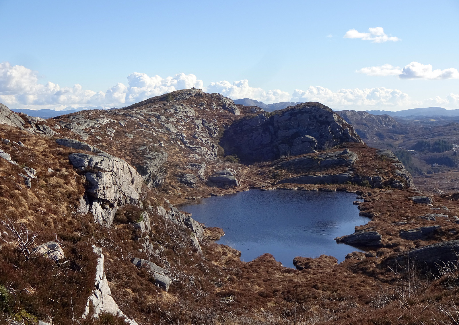 We started at Fjæreide and first went up Sauafjellet. From there, we then reconnected with the trail to Kårtveit north of Sauafjellet (descending Sauafjellet northwards without a trail was just fine; only the last few meters were a bit so that one had to find a way of where to go). We then followed the trail into the direction of Kårtveit, passing by Vardavatnet along the way. At Kårtveit, we wished to continue on another trail (to Spjeldsfjellet, a bit further north). We did not see a more straight-forward way then to first step out and onto road 5242, then follow this road northwards for some 200-300 meters, before then turning right and onto the planned trail, again. To pass by Urafjellet in its north (as planned), we needed to find the right "turn left" where also the >>>
Haganesfjellet from Liaskjeret via Lundaneset
- Dato:
- 16.03.2024
- Turtype:
- Fottur
- Turlengde:
- 2:30t
- Distanse:
- 7,4km
 We took the car to Liaskjeret in the east of Liatårnet on Sotra and started our hike at Jonsokhaugen. From there, we first followed the road southwards until its end at Gulenakken. There, we stepped down towards the coast and passed by Nordra Skagavika to cross over to Skaget and Skaghaugen. From Skaghaugen, we enjoyed some nice views across Røssevikvatnet, before continuing further southwards to Lundaneset. This stretch is without trail, but easy to traverse. From Lundaneset, we then started our ascent to Haganesfjellet, first aiming at Kjempa. Near Kjerringastigen, we then started our ascent to Alteret. At about 150 mosl, there's a slightly steeper section, where hands help out with the ascent. From Alteret, we crossed over Adneviksbakkane, making another slightly steeper ascent >>>
Ørnafjellet and Austre Høghaugen
- Dato:
- 17.02.2024
- Turtype:
- Fottur
- Turlengde:
- 3:30t
- Distanse:
- 7,9km
 We expected some nice sun and decided to enjoy the day with an exploration of a part of Sotra that we had not visited before. We drove the car to Sotra and there to Fjell. South of Fjell, along Søre Fjellavegen and right next to Gardstjørna, we parked next to the road and started our hike, walking down a simple road towards Fjellspollen. Still on this road, we conveniently crossed over the waters, that spring down from Bosvatnet to Litlepollen, using the road-bridge. Studying the map at home had suggested that starting our ascent up to Ørnafjellet would be possible right from the road in the north of Litlepollen. Once there, however, we saw that the hill-side appeared a bit steeper than originally expected. Still, we could make it up to the heights in the north of Litlepollen without >>>
Pyttane in windy weather
- Dato:
- 03.02.2024
- Turtype:
- Fjelltur
- Turlengde:
- 1:30t
- Distanse:
- 6,7km
 With quite a bit of weather outside, we decided to "just" go up and down Pyttane on Sotra. We took the car to Ekrhovdvegen in the very east of Sotra and parked near Nordre Stølen, where the service road up to Pyttane starts. We then walked up to the radar stations, experiencing significant weather on the top (strong winds, some precipitation). While it was nice to get out into the fresh air, we still did not feel like staying up there "in the elements" for any prolonged time, thus walking back down more or less immediately, again. All in all, this walk up to Pyttane is always nice (and easy), lending itself well to getting some fresh air without an all-too-long trip.
Selected photos are available as Google photo album .
See also the related FB-page Hiking around Bergen, Norway .
Web page WestCoastPeaks.com provides useful information about Liatårnet
and also Petter Bjørstad has a >>>
With quite a bit of weather outside, we decided to "just" go up and down Pyttane on Sotra. We took the car to Ekrhovdvegen in the very east of Sotra and parked near Nordre Stølen, where the service road up to Pyttane starts. We then walked up to the radar stations, experiencing significant weather on the top (strong winds, some precipitation). While it was nice to get out into the fresh air, we still did not feel like staying up there "in the elements" for any prolonged time, thus walking back down more or less immediately, again. All in all, this walk up to Pyttane is always nice (and easy), lending itself well to getting some fresh air without an all-too-long trip.
Selected photos are available as Google photo album .
See also the related FB-page Hiking around Bergen, Norway .
Web page WestCoastPeaks.com provides useful information about Liatårnet
and also Petter Bjørstad has a >>>
Bekhilderen south of Telavåg
- Dato:
- 24.09.2023
- Turtype:
- Fottur
- Turlengde:
- 3:00t
- Distanse:
- 9,0km
 Between the rain, and also taking the tide schedule into account, late Sunday morning offered a promising opportunity to visit Bekhilderen in the south of Telavåg. While approaching Telavåg with the car, we found a convenient spot at the side of Telavågvegen to park the car (just some 200 meters south of the sports arena of Telavåg. From there, we walked first along Selstøsjøen and then Håvarden. If you watch out for them, you can actually see small blue markers (Nordsjøløypa), leading the way. Before reaching house #33 at Håvarden, one then follows the gravel road towards the southeast. At the end of this (short) gravel road, one comes down to the inner parts of Selstøvågen and only a few meters towards the east, one then finds Selstøkverna, an old, renovated mill. After >>>
Liatårnet from Liaskjeret
- Dato:
- 11.08.2023
- Turtype:
- Fottur
- Turlengde:
- 4:30t
- Distanse:
- 9,1km
 We took the car from Bergen towards the west, crossing over Sotrabrua. In the west of Bildøya, we turned south (onto Døsjevegen), driving to Liaskjeret in the east of Liatårnet. From Liaskjærshallen, we then started our hike with our first goal being the trail that leads up to Liatårnet from Hølo. To get there, we had the choice between walking along Liaskjervegen for a good stretch and the alternative of following a simple trail above (in the west) of the houses. Choosing the latter, we first walked up Elvabakkvegen to get to the nearest trail head near house #11. A few hundred meters further west (and up a little), we then turned right (northwards), aiming for Skoradalen via a simple trail. West of Skogsbrekko, however, we did not really find a good way to continue further to >>>
Gjenekletten and Søre Sandknappen on Blomøyna
- Dato:
- 19.06.2023
- Turtype:
- Fottur
- Turlengde:
- 3:00t
- Distanse:
- 7,3km
 We were up for another trip to Øygarden and chose Blomøyna for a short hike. We left Bergen towards the west and turned right (northwards) on Sotra near Kolltveit. We then followed road #561 until we passed Rong and arrived at Blomøyna via the bridge over Ulvsundet. We then parked right next to road Blomøyvegen (south of Søre Sæle). From there, we first walked along the road (northwards) for a bit (until we had walked around Blomvatnet on our left). There, at Blom, we then left the road towards the right (north) in order to find a connection to Gjenekletten. We first found a proper trail, leading to house #255. Before getting there, we then left this trail and crossed over a little ditch in the northwest of this house. Further north, however, we couldn't see any nice continuation >>>
Round around Ono
- Dato:
- 04.06.2023
- Turtype:
- Fottur
- Turlengde:
- 3:00t
- Distanse:
- 9,3km
 While checking for new places in Øygarden that we had not visited so far, we found Ono and decided to make a hike there. After driving first westwards out of Bergen (towards Sotra), we then turned right (in northern direction) near Kolltveit, following then road #561. At Rong, we then turned left (westwards, again) in order to get over to Ono (passing the school of Rong along Svartevikvegen). After crossing two small bridges, we had arrived at Ono. There, we parked "at once" next to the road Onevegen. The southern part of Ono is well marked for hikers -- especially those, who wish to visit Dethloffhytta in the southwest of Ono. We followed first this main trail (in southwestern direction) until we crossed over the inner end of Stekkane. On the other, southern side, we then >>>
Førdesveten from Vorland
- Dato:
- 18.03.2023
- Turtype:
- Fottur
- Turlengde:
- 4:00t
- Distanse:
- 11,0km
 We decided to hike Førdesveten in the south of Sotra and planned for an approach from the northwest (from Vorland). After driving south from Fjell, we parked along Sundvegen, where one also finds the head of a trail that leads through Grøndalen into the direction of Vorlandsvatnet. Using this trail, we approached Vorlandsvatnet at Vassvika from the northwest, following a trail that passes by Vorlandsvatnet in its northeast. This is a nice and convenient trail that leads all the way to the southern-most point of Vorlandsvatnet. There, one could "back out", again, following a gravel road towards the west. Instead, we entered the little valley that comes down there from the south (mostly). After only about 100m into this valley, we ascended (kind of steeply) to the southeast, >>>
